19 Apr 2023 Market Close & Major Financial Headlines: Small Caps Nosedive, While The Dow Remained Above The Unchanged Line During The Entire Session, Marking The Sixth Down Session For The S&P 500

Summary Of the Markets Today:

  • The Dow closed up 211 points or 0.56%,
  • Nasdaq closed down 2.05%,
  • S&P 500 closed down 0.88%,
  • Gold $2,403 up $4.80,
  • WTI crude oil settled at $83 up $0.48,
  • 10-year U.S. Treasury 4.621% down 0.024 points,
  • EUR/USD index $1.065 up $0.001,
  • Bitcoin $64,299 up $921 (1.45%), – Historic high 73,798.25
  • Baker Hughes Rig Count: U.S. +2 to 619 Canada -14 to 127

*Stock data, cryptocurrency, and commodity prices at the market closing.


Click here to read our current Economic Forecast – April 2024 Economic Forecast: Economy Marginally Improving But Growth Will Be Weak


Today’s Economic Releases Compiled by Steven Hansen, Publisher:

No releases today

Here is a summary of headlines we are reading today:

Click on the “Read More” below to access these, other headlines, and the associated news summaries moving the markets today.

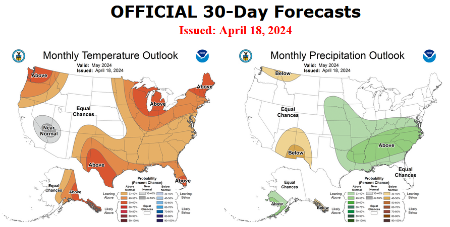
NOAA Updates its Seasonal Outlook on April 18, 2024 – La Nina is Coming: Published April 19, 2024

On the third Thursday of the month right on schedule NOAA issued their updated Seasonal Outlook which I describe as their Four-Season Outlook because it extends a bit more than one year into the future. The information released also included the Mid-Month Outlook for the following month plus the weather and drought outlook for the next three months.  I present the information issued by NOAA and try to add context to it. It is quite a challenge for NOAA to address the subsequent month, the subsequent three-month period as well as the twelve successive three-month periods for a year or a bit more.

With respect to the long-term part of the Outlook which I call the Four-Season Outlook, there is a rapid transition from El Nino to ENSO Neutral to LaNina. So getting the timing right is challenging. La Nina is now the likely scenario for this summer almost to the end of the forecast period. The Outlook beyond May has not been significantly changed from what was issued last month. This suggests increasing confidence in the outlook.  I may write another article on the implications of this forecast for agriculture and perhaps energy usage.

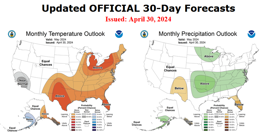
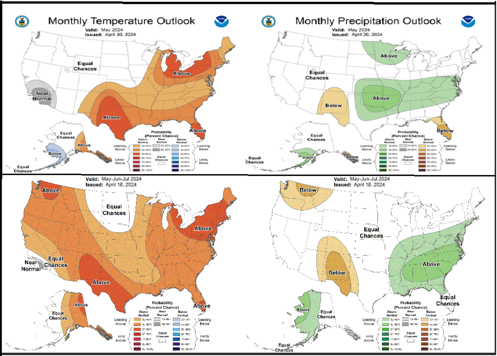
First, Let’s Take a Look at the (mid-month) Outlook for May

It will be updated on the last day of April.

The top row is what is now called the Mid-Month Outlook for next month which will be updated at the end of this month. There is a temperature map and a precipitation map. The second row is a three-month outlook that includes next month.  I think the outlook maps are self-explanatory. What is important to remember is that they show deviations from the current definition of normal which is the period 1991 through 2020.  So this is not a forecast of the absolute value of temperature or precipitation but the change from what is defined as normal or to use the technical term “climatology”.

Notice that the Outlook for next month and the three-month Outlook are somewhat different, especially with regard to temperature.  This tells us that June and July will be different than May to some extent.

The full NOAA Seasonal Outlook extends through May/June/July of 2025 (yes that is more than a year out). All of these maps are in the body of the article. Large maps are provided for May and the three-month period May/June/July.  Small maps are provided beyond that through May/June/July of 2025 with a link to get larger versions of these maps.

NOAA provides an excellent discussion to support the maps. It is included in the body of this article. In some cases, one will need to click on “read more” to read the full article.  For those on my email list where I have sent the url of the article, that will not be necessary.

Today Through the Fourth Friday (22 to 28 days) Weather Outlook for the U.S. and a Six-Day Forecast for the World: posted April 19, 2024

It is difficult to find a more comprehensive Weather Outlook anywhere else with the ability to get a local 10-day Forecast also.

This article focuses on what we are paying attention to in the next 48 to 72 hours. The article also includes weather maps for longer-term U.S. outlooks and a six-day World weather outlook which can be very useful for travelers.

First the NWS Short Range Forecast. The afternoon NWS text update can be found here but it is unlikely to have changed very much. The images in this article automatically update.

Short Range Forecast Discussion
NWS Weather Prediction Center College Park MD
Fri Apr 19 2024
Valid 12Z Fri Apr 19 2024 – 12Z Sun Apr 21 2024

…Scattered showers and thunderstorms push into the central/southern
Appalachians and Southeast today…

…Wet snow and wintry mix over the central High Plains on Saturday as
heavy rain threat develops over parts of Texas and the lower Mississippi
Valley…

…Unseasonably warm across much of the South and Southwest as below
average temperatures expand throughout the Great Plains and Midwest…

The main weather feature and focus for showers and thunderstorms through
this weekend will be a cold front progressing across the East and stalling
between the Southeast and southern Texas. Unsettled weather will start the
short range forecasting period located across the central/southern
Appalachians and Southeast. These locations will have the greatest chances
for isolated thunderstorms to become strong enough to produce locally
damaging wind gusts and hail. Elsewhere, light showers are expected to
extend into the Northeast through tonight.

Precipitation is also expected to become more widespread and increase in
intensity throughout the central High Plains and Colorado Front Range by
tonight. A mix of rain and snow is likely, with heavy snow (greater than 4
inches) most likely along the Front Range and lesser amounts into the
foothills on eastward into the High Plains. Snow chances should gradually
subside by Saturday evening, but chilly temperatures will remain across
much of the Great Plains on Sunday.

Meanwhile, instances of heavy rain and scattered flash flooding are
possible on Saturday across parts of the southern Plains and lower
Mississippi Valley as numerous showers and embedded thunderstorms develop
to the north of a stationary front. Repeating rounds of intense rainfall
and areas with wet antecedent ground conditions have prompted a Slight
Risk (level 2/4) of Excessive Rainfall between central Texas and the
ArkLaMiss region. Fortunately, this system is forecast to quickly exit to
the east on Sunday and shift shower and thunderstorm chances to the
Southeast, limiting the flooding threat somewhat.

A quick-moving system will also swing light precipiation into the
Northwest this weekend, which will continue to promote above average
temperatures over the Southwest. Spring warmth will also be found
throughout much of the South today and Saturday for places avoiding
afternoon rain. For a majority of the Nation; however, well below average
temperatures will remain locked in place this weekend underneath high
pressure streaming in from Canada. Highs are anticipated to range from the
40s in the northern Plains and Upper Midwest to the 60s from the
Mid-Atlantic to the Tennessee Valley. Lows into the 30s could produce
frost and/or freeze conditions in the Midwest as well.

To get your local forecast plus active alerts and warnings click HERE and enter your city, state or zip code.

Learn about wave patterns HERE.

Then, looking at the world and of course, the U.S. shows here also. Today we are looking at precipitation.

Please click on “Read More” below to access the full Daily Report issued today.

18 Apr 2023 Market Close & Major Financial Headlines: The S&P 500 Suffered Its Fifth Day In The Red Closing Down With The Nasdaq Down And The Dow Fractionally Higher In The Green

Summary Of the Markets Today:

  • The Dow closed up 22 points or 0.06%,
  • Nasdaq closed down 0.52%,
  • S&P 500 closed down 0.22%,
  • Gold $2,396 up $7.00,
  • WTI crude oil settled at $83 up $0.05,
  • 10-year U.S. Treasury 4.625% up 0.052 points,
  • USD index $106.16 up $0.210,
  • Bitcoin $63,554 up $2,462 (3.93%)

*Stock data, cryptocurrency, and commodity prices at the market closing.


Click here to read our current Economic Forecast – April 2024 Economic Forecast: Economy Marginally Improving But Growth Will Be Weak


Today’s Economic Releases Compiled by Steven Hansen, Publisher:

The Philly Fed Manufacturing survey shows activity in the region continued to expand this month with the diffusion index for current general activity rose 12 points to 15.5 in April, its third consecutive positive reading and highest reading since April 2022. The survey’s indicators for general activity, new orders, and shipments all rose. However, the employment index remained negative. Both price indexes continue to suggest overall price increases. Most future activity indicators declined but continue to suggest that firms expect growth over the next six months. Historically, the Philly Fed Manufacturing survey has been the most positive of all the regional fed manufacturing surveys, and it likely that manufacturing has been contracting for so long that year-over-year comparisons will shortly be positive.

Existing-home sales fell 3.7% year-over-year as affordability continues to take its toll on existing homes. The median existing-home sales price rose 4.8% from March 2023. The inventory of unsold existing homes is 3.2 months’ supply at the current monthly sales pace. NAR Chief Economist Lawrence Yun stated:

Though rebounding from cyclical lows, home sales are stuck because interest rates have not made any major moves. There are nearly six million more jobs now compared to pre-COVID highs, which suggests more aspiring home buyers exist in the market.

In the week ending April 13, the advance figure for seasonally adjusted initial unemployment claims 4-week
moving average was 214,500, unchanged from the previous week’s revised average. The previous week’s average was
revised up by 250 from 214,250 to 214,500.

The Conference Board Leading Economic Index® (LEI) for the U.S. decreased by 0.3 percent in March 2024 to 102.4 (2016=100), after increasing by 0.2 percent in February. Over the six-month period between September 2023 and March 2024, the LEI contracted by 2.2 percent—a smaller decrease than the 3.4 percent decline over the previous six months. Justyna Zabinska-La Monica, Senior Manager, Business Cycle Indicators, at The Conference Board added:

February’s uptick in the U.S. LEI proved to be ephemeral as the Index posted a decline in March. Negative contributions from the yield spread, new building permits, consumers’ outlook on business conditions, new orders, and initial unemployment insurance claims drove March’s decline. The LEI’s six-month and annual growth rates remain negative, but the pace of contraction has slowed. Overall, the Index points to a fragile—even if not recessionary—outlook for the U.S. economy. Indeed, rising consumer debt, elevated interest rates, and persistent inflation pressures continue to pose risks to economic activity in 2024. The Conference Board forecasts GDP growth to cool after the rapid expansion in the second half of 2023. As consumer spending slows, US GDP growth is expected to moderate over Q2 and Q3 of this year.

Here is a summary of headlines we are reading today:

Click on the “Read More” below to access these, other headlines, and the associated news summaries moving the markets today.

Today Through the Fourth Friday (22 to 28 days) Weather Outlook for the U.S. and a Six-Day Forecast for the World: posted April 18, 2024

It is difficult to find a more comprehensive Weather Outlook anywhere else with the ability to get a local 10-day Forecast also.

This article focuses on what we are paying attention to in the next 48 to 72 hours. The article also includes weather maps for longer-term U.S. outlooks and a six-day World weather outlook which can be very useful for travelers.

First the NWS Short Range Forecast. The afternoon NWS text update can be found here but it is unlikely to have changed very much. The images in this article automatically update.

Short Range Forecast Discussion

Short Range Forecast Discussion
NWS Weather Prediction Center College Park MD
Thu Apr 18 2024
Valid 12Z Thu Apr 18 2024 – 12Z Sat Apr 20 2024

…Severe weather and isolated flash flooding for the Middle
Mississippi/Lower Ohio Valleys and Southern Plains Thursday…

…Showers, thunderstorms, and cooler weather for much of the Southern
Plains Friday; wintry mix into the central High Plains…

…Unseasonably warm conditions for much of the southern U.S.; chillier
weather expands across the northern Rockies/Plains and Upper Midwest…

A weakening system over the Northeast will bring some shower chances to
the northern Mid-Atlantic into New England Thursday. To the west, a much
broader area of showers and thunderstorms is expected ahead of a cold
front from the Middle Mississippi/Lower Ohio Valleys southwestward through
the Southern Plains. Sufficient shear and instability will be in place in
the Middle Mississippi/Lower Ohio Valleys for some organized
thunderstorms/line segments, with the Storm Prediction Center noting an
Enhanced Risk (level 3/5) for severe weather. Very large hail, damaging
winds, and a few tornadoes will all be possible. A Slight Risk (level 2/5)
extends southwestward along the front into Texas, with a more isolated
threat for some large hail and damaging winds. The prospect of widespread
storm coverage, especially for areas further north through the Middle
Mississippi Valley, and the potential for heavy downpours may lead to some
isolated flash flooding as well.

Shower and thunderstorm chances will progress eastward with the advancing
cold front into the Appalachians by Friday morning and eventually the East
Coast by Friday evening, though coverage and intensity looks to trend
downward during the day as the front approaches the coast. A few isolated
severe thunderstorms may occur over the Southeast. Areas of moderate to
rainfall will linger over portions of the Southern Plains along and north
of the cold front over Texas as it begins to slow and stall over the
region. Some isolated flooding will be possible. Post-frontal upslope flow
will also bring precipiation chances to the central High Plains and Front
Range of the Rockies, with a mix of rain and snow showers for lower
elevations and snow into the mountains. Any accumulations at the lower
elevations should remain minimal.

Forecast high temperatures remain rather warm to even hot across southern
portions of the country Thursday, with highs in the mid-80s to near 90
from Texas eastward through the Southeast, and even as far north as
portions of the Middle Mississippi and Lower Ohio Valleys. Areas of west
Texas and along the Rio Grande Valley will see mid- to upper 90s.
Conditions will be similarly hot in the Desert Southwest. The southerly
progression of the cold front will bring much cooler temperatures Friday
across northern Texas and into the Mid-South and Tennessee Valley as highs
drop into the 60s and 70s. Conditions will remain hot south of the frontal
boundary. Further north, highs will range in the 50s and 60s across the
central Plains northeastward into the Great Lakes region, with 60s and 70s
from the Ohio Valley into the southern Mid-Atlantic. The northern
Mid-Atlantic into New England will be a bit chilly Thursday with highs in
the 40s and 50s, with temperatures expected to recover a bit Friday. Cold
temperatures will also expand in coverage across the northern
Rockies/Plains and Upper Midwest as high pressure settles in over the
region, with highs in the 30s and 40s. In the West, highs will range from
the 60s and 70s from the Pacific Northwest southward through coastal
California and inland across the Great Basin, with 80s for the central
California valleys.

To get your local forecast plus active alerts and warnings click HERE and enter your city, state or zip code.

Learn about wave patterns HERE.

Then, looking at the world and of course, the U.S. shows here also. Today we are looking at precipitation.

Please click on “Read More” below to access the full Daily Report issued today.

17 Apr 2023 Market Close & Major Financial Headlines: Feds Expected Rate-Cuts Push Markets Down Into The Red, Closing Near Session Lows

Summary Of the Markets Today:

  • The Dow closed down 46 points or 0.12%,
  • Nasdaq closed down 1.15%,
  • S&P 500 closed down 0.58%,
  • Gold $2,388 down $19.40,
  • WTI crude oil settled at $83 down $2.60,
  • 10-year U.S. Treasury 4.659% down 0.031 points,
  • USD index $105.83 down $0.374,
  • Bitcoin $61,116 down $1,696 (2.68%)

*Stock data, cryptocurrency, and commodity prices at the market closing.


Click here to read our current Economic Forecast – April 2024 Economic Forecast: Economy Marginally Improving But Growth Will Be Weak


Today’s Economic Releases Compiled by Steven Hansen, Publisher:

The Ports of Los Angeles and Long Beach – which handle 40% of all container imports into the U.S. – show imports increased 14% year-over-year whilst exports increased 8% year-over-year. The import growth shows that the economy is gaining steam, but consider that imports remain below the pre-pandemic peaks.

According to the April 2024 Beige Book:

Overall economic activity expanded slightly, on balance, since late February. Ten out of twelve Districts experienced either slight or modest economic growth—up from eight in the previous report, while the other two reported no changes in activity. Consumer spending barely increased overall, but reports were quite mixed across Districts and spending categories. Several reports mentioned weakness in discretionary spending, as consumers’ price sensitivity remained elevated. Auto spending was buoyed notably in some Districts by improved inventories and dealer incentives, but sales remained sluggish in other Districts. Tourism activity increased modestly, on average, but reports varied widely. Manufacturing activity declined slightly, as only three Districts reported growth in that sector. Contacts reported slight increases in nonfinancial services activity, on average, and bank lending was roughly flat overall. Residential construction increased a little, on average, and home sales strengthened in most Districts. In contrast, nonresidential construction was flat, and commercial real estate leasing fell slightly. The economic outlook among contacts was cautiously optimistic, on balance.

Note that the Beige Book is an anecdotal report published by the United States Federal Reserve Board that summarizes economic conditions across the 12 Federal Reserve Districts. It’s also known as the Summary of Commentary on Current Economic Conditions by Federal Reserve District. The report is published eight times a year, before the Federal Open Market Committee meets.

Here is a summary of headlines we are reading today:

Click on the “Read More” below to access these, other headlines, and the associated news summaries moving the markets today.

Today Through the Fourth Friday (22 to 28 days) Weather Outlook for the U.S. and a Six-Day Forecast for the World: posted April 17, 2024

It is difficult to find a more comprehensive Weather Outlook anywhere else with the ability to get a local 10-day Forecast also.

This article focuses on what we are paying attention to in the next 48 to 72 hours. The article also includes weather maps for longer-term U.S. outlooks and a six-day World weather outlook which can be very useful for travelers.

First the NWS Short Range Forecast. The afternoon NWS text update can be found here but it is unlikely to have changed very much. The images in this article automatically update.Short Range Forecast Discussion

NWS Weather Prediction Center College Park MD
220 PM EDT Wed Apr 17 2024
Valid 00Z Thu Apr 18 2024 – 00Z Sat Apr 20 2024

…Severe weather and isolated flash flooding for the Great Lakes/Ohio
Valley this evening; threat shifts to the Ohio and middle Mississippi
valleys and Southern Plains Thursday…

…Warm to hot temperatures across the southern U.S.; chillier weather
spreading southeast from the northern Rockies/Plains…

Showers and thunderstorms will continue to develop into the evening along
and ahead of a cold front now advancing eastward across Lower Michigan and
the Ohio Valley. Some of these storms may become strong to severe,
producing damaging winds, large hail, and a few tornadoes. In addition to
severe weather, locally heavy rainfall and isolated flash flooding are
concerns as well.

Later this evening, storms are forecast to develop from the central Plains
into the lower Missouri Valley. These storms too may become strong to
severe, with damaging hail expected to be the primary threat.

As the system in Plains moves further east, storms are likely to redevelop
from the Ohio Valley into the southern Plains on Thursday. Severe weather
will once again become a concern, especially across portions of the mid
Mississippi into the lower Ohio valleys. The Storm Prediction Center has
issued an Enhanced Risk (level 3/5) for portions of the region, noting
that strong to severe storms capable of damaging winds, and possibly a few
tornadoes, are likely tomorrow. While widespread heavy rains are not
expected, locally heavy accumulations resulting in isolated flash flooding
are possible.

Temperatures across the southern U.S. will remain warm through the period,
with highs in the upper 80s and 90s common from the Southwest to the
Southeast over the next couple of days. Much cooler temperatures now
centered over the northern Rockies and Plains will spread southeastward,
lowering temperatures across much of the Midwest and Ohio Valley by Friday.

To get your local forecast plus active alerts and warnings click HERE and enter your city, state or zip code.

Learn about wave patterns HERE.

Then, looking at the world and of course, the U.S. shows here also. Today we are looking at precipitation.

Please click on “Read More” below to access the full Daily Report issued today.

16 Apr 2023 Market Close & Major Financial Headlines: Wall Street Markets Opened Mixed, Traded Mostly Sideways In The Red, Finally Closing Mixed In Last Minute Trading

Summary Of the Markets Today:

  • The Dow closed up 64 points or 0.17%,
  • Nasdaq closed down 0.12%,
  • S&P 500 closed down 0.21%,
  • Gold $2,407 up $23.60,
  • WTI crude oil settled at $85 down $0.04,
  • 10-year U.S. Treasury 4.659% up 0.031 points,
  • USD index $106.36 up $0.150,
  • Bitcoin $62,802 down $519 (0.82%)

*Stock data, cryptocurrency, and commodity prices at the market closing.


Click here to read our current Economic Forecast – April 2024 Economic Forecast: Economy Marginally Improving But Growth Will Be Weak


Today’s Economic Releases Compiled by Steven Hansen, Publisher:

Privately‐owned housing units authorized by building permits in March 2024 were 1.5 above March 2023. Privately‐owned housing starts were 4.3% below March 2023. Privately‐owned housing completions were 3.9% below March 2023. The bright spot in the economy (residential housing) appears to be currently slowing.

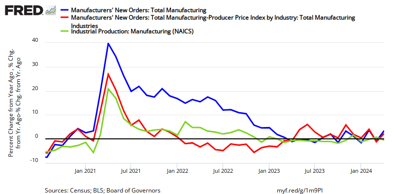
Industrial production slightly improved but remains down 0.001% year-over-year with components manufacturing up 1.0% year-over-year), mining down 2.0% year-over-year, and utilities down 3.1% year-over-year. This is the first month this year that manufacturing showed a positive year-over-year growth.

U.S. single-family rents rose by 3.4% year over year in February 2024, the strongest growth recorded in 10 months. Molly Boesel, principal economist for CoreLogic added:

Single-family rent growth regained strength in February, posting the highest annual appreciation since April 2023. Monthly rent growth also picked up in February and was higher than what is typically recorded in winter months. Lower-priced properties had the smallest annual rent growth in February, which should be welcome news to renters. However, properties in this price range have seen gains of more than 30% over the past four years, a slightly larger increase than those in the higher-priced range.

Here is a summary of headlines we are reading today:

Click on the “Read More” below to access these, other headlines, and the associated news summaries moving the markets today.

Today Through the Fourth Friday (22 to 28 days) Weather Outlook for the U.S. and a Six-Day Forecast for the World: posted April 16, 2024

[Note that at the time of publication some NOAA websites seemed to not be working. The NWS text forecast is working. One can find the U.S. forecast in the international forecasts since the U.S. is part of the world.]

It is difficult to find a more comprehensive Weather Outlook anywhere else with the ability to get a local 10-day Forecast also.

This article focuses on what we are paying attention to in the next 48 to 72 hours. The article also includes weather maps for longer-term U.S. outlooks and a six-day World weather outlook which can be very useful for travelers.

First the NWS Short Range Forecast. The afternoon NWS text update can be found here but it is unlikely to have changed very much. The images in this article automatically update.

Short Range Forecast Discussion
NWS Weather Prediction Center College Park MD
Tue Apr 16 2024
Valid 12Z Tue Apr 16 2024 – 12Z Thu Apr 18 2024

…Storm system to bring the threat of severe weather and isolated flash
flooding to the Mississippi Valley Tuesday and the Lower Great Lakes/Ohio
Valley on Wednesday…

…Moderate to locally heavy snowfall expected over the next couple of
days for the northern Rockies…

…Warm temperatures continue across the South and Desert Southwest,
chillier weather expected for the Upper Great Lakes and northern Rockies…

A seasonably strong low pressure/frontal system over the central U.S. will
move from the Plains into the Mississippi Valley during the day Tuesday. A
sustained arc of showers and thunderstorms wrapping around the low over
the Northern Plains into the Upper Midwest this morning will continue to
progress to the northeast, with more scattered storms extending southward
through the central/southern Plains along an eastward advancing cold
front. A renewed round of storms is expected along and ahead of the cold
front Tuesday afternoon. Strong deep-layer and low-level shear along with
more than sufficient buoyancy will be available in the warm sector for
robust supercell development. The Storm Prediction Center has issued an
Enhanced Risk of Severe Weather (level 3/5) for portions of southern Iowa,
northeastern Missouri, and far western Illinois where these storms will
pose a threat for very large hail, damaging winds, and tornadoes,
including the risk for a strong tornado. A broader Slight Risk (level 2/5)
extends southward through Missouri into northern Arkansas where a more
isolated threat for storms will exist, but will still pose the threat for
all hazards. In addition to severe weather, rounds of heavy rainfall from
the more widespread storms over the Upper Midwest along with potentially
more scattered but heavier downpours with storms to the south through the
Middle Mississippi Valley will pose a threat for some isolated flash
flooding.

The system will continue eastward on Wednesday into the Great Lakes region
and Ohio Valley. Similar to Tuesday, storms will likely be ongoing
overnight Tuesday into early Wednesday, especially to the north from the
Upper Midwest into the Great Lakes. Some scattered storms may also
continue along the cold front as it pushes into the Ohio Valley. A renewed
round of storm development is expected ahead of the front by Wednesday
afternoon, with a Slight Risk of severe weather in place from eastern
Indiana into southern Michigan and western Ohio for the threat of large
hail, damaging winds, and a few tornadoes. The storms are forecast to
continue overnight Wednesday into the Mid-Atlantic. Again, similar to
Tuesday, more widespread rainfall over the Great Lakes and the potential
for some more potent downpours with storms further south will pose a
threat for some isolated flash flooding.

To the West, another upper-level trough/associated surface frontal system
pushing southeastward through the northern Rockies will bring the chance
for some moderate to locally heavy snow for higher elevations in the
mountains of Montana Tuesday and into Wyoming by Wednesday morning. Winter
weather-related advisories and warnings are in place for snow
accumulations generally between 6-12″, with higher amounts more likely in
Wyoming. Some lighter snow showers will also be possible along the
trailing end of the frontal system over the northern Cascades Tuesday.
Otherwise, the remainder of the country will be mostly dry. Temperatures
will tend to generally be at or above average along the southern tier of
the country with cooler temperatures along the northern tier. Forecast
highs in the 80s are expected from the Southern Plains east through the
Southeast, with 70s and 80s for California and the Central Plains east
through the Ohio Valley, and 70s in the Mid-Atlantic. The warmest
temperatures will be over the Desert Southwest as highs climb into the
90s. To the north, 50s and 60s are expected for the Pacific Northwest,
Northern Plains, and New England. Areas of the Upper Great Lakes and
northern Rockies will see the coolest temperatures, with highs mainly in
the 40s by Wednesday.

To get your local forecast plus active alerts and warnings click HERE and enter your city, state or zip code.

Above is a 72 hour animation of the forecast. Learn about wave patterns HERE.

Then, looking at the world and of course, the U.S. shows here also. Today we are looking at precipitation.

Please click on “Read More” below to access the full Daily Report issued today.