
Irene Wong: Dancing for fun and business
Irene never anticipated that her late-teen dream of ballroom dancing would not only come true but also blossom into a midlife passion and business in ballroom dancing.
Irene never anticipated that her late-teen dream of ballroom dancing would not only come true but also blossom into a midlife passion and business in ballroom dancing.

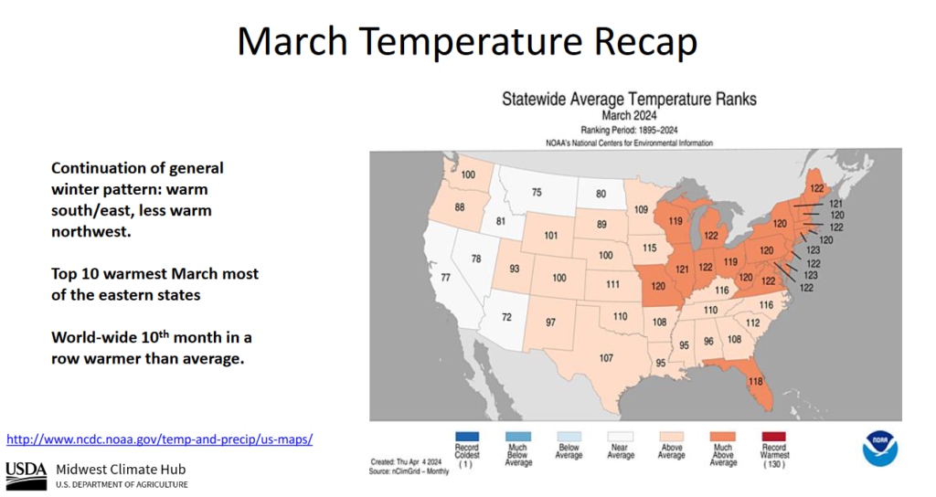
| You can see the large number of much above-average temperature states. Many of these were in the North Central area. |
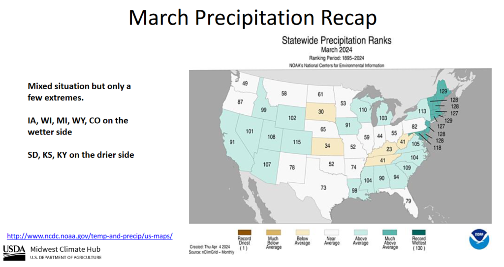
| The North Central had average to slightly above normal precipitation. It was very wet in the Northeast. |
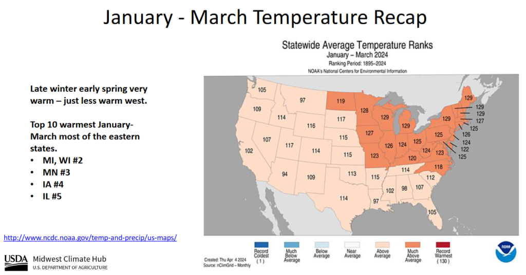
| Jan to March shows a similar situation but more states were above average or much above average. |
–
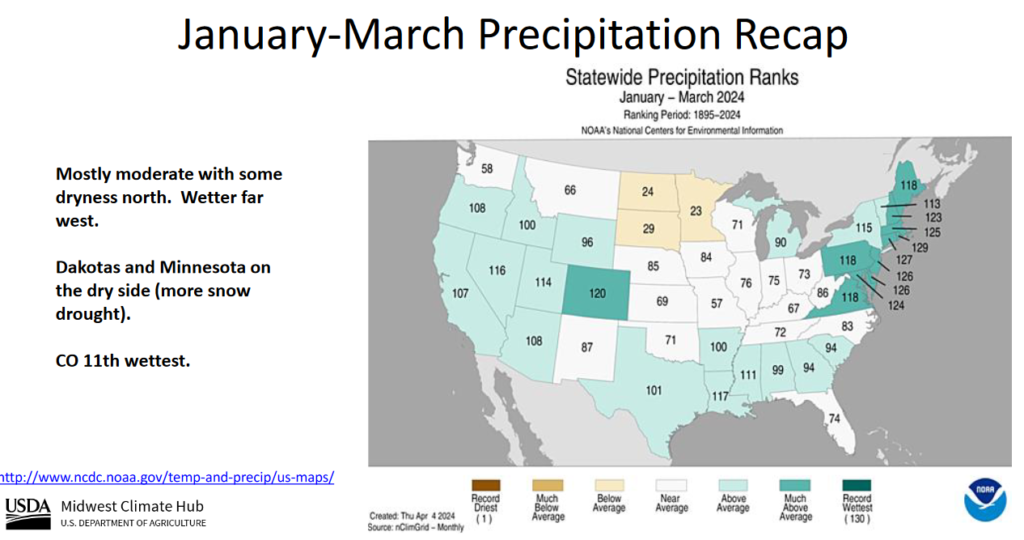
| This shows the El Nino pattern but not dramatically wet except in the Northeast. |
Short Range Forecast Discussion
NWS Weather Prediction Center College Park MD
348 AM EDT Wed Apr 24 2024Valid 12Z Wed Apr 24 2024 – 12Z Fri Apr 26 2024
…Unsettled weather and severe thunderstorm chances gradually expand
across much of the central United States over the next several days……Active fire weather pattern to become situated over the southern High
Plains……Above average temperatures shift from the Great Basin to the Plains,
while the West and East remain cool through the end of the week…The benign weather pattern experienced throughout much of the Nation over
the last few days is expected to conclude as developing upper troughing
over the western U.S. helps create a ripe spring severe weather setup over
parts of the central and southern Plains. This trough is expected to enter
the Southwest by early Thursday and swing into the central Plains by
Friday. At the surface, returning moisture from the Gulf of Mexico will
begin to lift northward today and pool along a gradually lifting warm
front draped across the southern Plains. Combined with a southern High
Plains dryline, a few developing thunderstorms could turn severe today
from West Texas to central Oklahoma, as well as the chances for isolated
flash flooding. A greater severe weather threat exists beginning on
Thursday as a surface cyclone rapidly deepens over the central High Plains
in response to the approaching upper level trough. The aforementioned warm
front is expected to continue lifting northward while the High Plains
dryline pushes east. This environment is anticipated to produce numerous
thunderstorms across the central and southern Plains, with scattered
storms turning severe. The Storm Prediction Center has issued an Enhanced
Risk (level 3/5) for severe weather across parts of
southwest/south-central Kansas and western Oklahoma into the eastern Texas
Panhandle. Very large hail, severe wind gusts, and a couple strong
tornadoes will all be possible. Multiple rounds of heavy rain could also
lead to scattered flash flooding, which has prompted a Slight Risk (level
2/4) of Excessive Rainfall across parts of northeast Oklahoma, eastern
Kansas, western Missouri, and northwest Arkansas. By Friday, the
aforementioned low pressure system is forecast to deepen and slide east
into the central Plains while shower and thunderstorm chances also push
eastward into the Upper Midwest, Middle/Lower Mississippi Valley, and
southern Plains.Behind the dryline across the southern High Plains, the combination of
very low relative humidity and gusty winds are expected to create Critical
Fire Weather on Thursday and Friday. Any fires that develop will likely
spread rapidly. Outdoor burning is not recommended. Additionally, gusty
winds up to 55 mph could lead to areas of blowing dust.Precipitation chances will also exist elsewhere across the Nation. A cold
front crossing the Northeast today will spread showers over the region,
with snow showers possible across northern New England. Unsettled weather
is expected to develop over the West, Great Basin, and Rockies as well
over the next few days underneath the deepening upper trough. Most
precipiation is expected to remain mostly light, with embedded downpours
and high elevation heavy snow by Friday across the Rockies. This active
weather will also lead to a cooling trend throughout the West compared to
the spring warmth felt over the last few days. Chilly weather is also
forecast across the Northeast through the end of the week as high pressure
builds southward from Canada. Low temperatures could dip below freezing on
Thursday morning and have prompted Freeze Watches to be issued from the
Lower Great Lakes to southern New England. Most of the above average
warmth will be found throughout the Plains, besides of any areas
experiencing prolonged periods of rainfall, with highs into the 80s
remaining across the Southern Tier States until Friday.
*Stock data, cryptocurrency, and commodity prices at the market closing.
Today’s Economic Releases Compiled by Steven Hansen, Publisher:
Sales of new single‐family houses in March 2024 is 8.3% above March 2023. The median sales price of new houses sold in March 2024 was $430,700. The average sales price was $524,800.
The seasonally‐adjusted estimate of new houses for sale at the end of March was 477,000. This represents a supply of 8.3 months at the current sales rate. New home sales have been a bright spot in the economy.

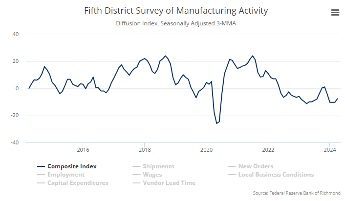
Richmond Fed Manufacturing activity remained slow in April 2024. The composite manufacturing index increased from −11 in March to −7 in April. Of its three component indexes, shipments increased from −14 to −10, new orders increased from −17 to −9, and employment fell from 0 to −2. Manufacturing is far from a bright spot in the current economy.
Here is a summary of headlines we are reading today:
Click on the “Read More” below to access these, other headlines, and the associated news summaries moving the markets today.

Short Range Forecast Discussion
NWS Weather Prediction Center College Park MD
Tue Apr 23 2024
Valid 12Z Tue Apr 23 2024 – 12Z Thu Apr 25 2024…Unsettled weather and severe thunderstorm chances ramp up across parts
of the central and southern Plains this week……Above average temperatures throughout the western and central United
States, with cooler weather in the Great Lakes and much of the East…The mostly quiet weather pattern experienced the last few days over the
Lower 48 is expected to gradually retreat as an upper trough develops over
the western U.S. midweek and sparks increasing thunderstorm chances
throughout the Great Plains and parts of the Midwest. First, a pair of
cold fronts crossing the Great Lakes and Ohio Valley today will spread
showers and isolated thunderstorms over the region before reaching the
Northeast on Wednesday. Temperatures may drop rapidly enough for
precipitation to end as snow across northern New England. Meanwhile, a
trailing cold front entering the southern Plains will be the focus for
thunderstorms over the next few days from northern and West Texas to
central Oklahoma. A few storms could be capable of producing large hail
and damaging wind gusts across northwest Texas today, which has prompted
the Storm Prediction Center to issue a Slight Risk (level 2/5) of severe
weather. A few isolated severe thunderstorms may also develop off a
southern High Plains dryline on Wednesday ahead of the approaching western
upper trough. This upper level system will aid in more widespread shower
and thunderstorm activity throughout the central and southern Plains on
Thursday. Scattered severe thunderstorms are possible as low pressure
develops over the central High Plains and a strengthening dryline pushes
eastward, with most of the severe potential located between south-central
Nebraska and northern Texas. Along with the severe thunderstorm threat,
heavy rain could lead to isolated instances of flash flooding.Elsewhere, unsettled weather is also in the forecast throughout parts of
the Great Basin and eventually the Pacific Northwest by Thursday as
initial upper ridging and well above average temperatures gradually erode.
Much of the rainfall is expected to be mostly beneficial outside of any
lightning potential with thunderstorms over the central Great Basin. Highs
throughout the southwest are anticipated to reach the 80s and 90s through
Wednesday, with 60s and 70s for much of the Intermountain West.Cooler weather is in store for the Great Lakes and much of the eastern
U.S. beginning with the potential for frost this morning from the southern
Appalachians to southern New England. Lows dipping into the 30s here may
damage sensitive plants and vegetation if left unprotected. Temperatures
are forecast to rebound this afternoon as highs reach into the 60s and 70s
ahead of the next spring cold front entering from the Great Lakes tonight.
This will allow for midweek temperatures to drop to around 10 to 20
degrees below average for the Great Lakes and Northeast, equating to high
temperatures ranging from the 40s in northern locations to 60s along the
northern Mid-Atlantic coastline.
*Stock data, cryptocurrency, and commodity prices at the market closing.
Today’s Economic Releases Compiled by Steven Hansen, Publisher:
The Chicago Fed National Activity Index three-month moving average, CFNAI-MA3, increased to –0.19 in March 2024 from –0.28 in February. The CFNAI-MA3 is used for economic forecasting – and is my favorite coincident index. A zero value for the CFNAI has been associated with the national economy expanding at its historical trend (average) rate of growth which the current values indicate soft growth. In March, Fifty indicators improved from February to March, while 35 indicators deteriorated.

Here is a summary of headlines we are reading today:
Click on the “Read More” below to access these, other headlines, and the associated news summaries moving the markets today.
Short Range Forecast Discussion
NWS Weather Prediction Center College Park MD
Mon Apr 22 2024
Valid 12Z Mon Apr 22 2024 – 12Z Wed Apr 24 2024…Shower and thunderstorm chances stretch from the Upper Midwest and
Great Lakes to the Southern Plains over the next few days……Chilly and frosty start to Earth Day throughout the Ohio Valley and
Mid-Atlantic, while well above average temperatures remain in place across
much of the Southwest/Great Basin…Precipitation chances are expected to remain mostly scattered and light
throughout much of the Nation into midweek as atmospheric moisture content
remains sparse following the passage of a strong cold front into the Gulf
of Mexico and western Atlantic. A few thunderstorms are possible across
the central and southern Florida Peninsula today as the aforementioned
cold front makes it’s final exit. A few storms could turn severe and
produce damaging wind gusts and hail. Thus, the Storm Prediction Center
has issued a Marginal Risk (level 1/5) for severe weather across southeast
Florida. Otherwise, rain chances are forecast to progress eastward from
the northern Plains to the Upper Midwest today along a swiftly moving
Pacific cold front. By Tuesday, rain chances are anticipated to stretch
from the Great Lakes and Ohio Valley to the Southern Plains. The heaviest
rain associated with this system is possible across parts of
central/eastern Oklahoma and western Arkansas on Wednesday, but this
aspect of the forecast remains somewhat uncertain.Temperatures are expected to start off in the 30s throughout much of the
Midwest, Ohio and Tennessee valleys, Mid-Atlantic, and Northeast as strong
high pressure leads to clear skies and cold temperatures at ground-level.
Lows into the low 30s are likely to lead to frost/freeze conditions and
has prompted Frost Advisories and Freeze Warnings for much of the region
where the growing season has already begun. Warmer weather is forecast to
begin spreading eastward on Tuesday, but will be short-lived as the next
shot of cold air enters the Great Lakes Tuesday night. Warmer weather is
anticipated to remain throughout the Southwest, Great Basin, and parts of
the Southern Plains through midweek. Highs can be expected to reach into
the 70s and 80s, with 90s and low 100s in the typical warm spots
throughout the Desert Southwest.
The full data sets for the 56 years from 1966 to 2022 show no discernable association patterns (correlations) for federal deficit spending (FDS) and inflation changes.1 Thus, we started an analysis by looking specifically at the various regimes of inflation change during the 56-year timeline. The most recent post2 analyzed the seven time periods over 56 years with positive inflation surges. This article analyzes the association between CPI changes and FDS changes during the four periods from 1966 to 2022 with negative inflation (disinflation/deflation) surges.

Image by Nicolae Baltatescu from Pixabay.
Short Range Forecast Discussion
NWS Weather Prediction Center College Park MD
Sun Apr 21 2024
Valid 12Z Sun Apr 21 2024 – 12Z Tue Apr 23 2024…Lingering showers and storms expected across the Southeast today and
Florida through Monday……Above average temperatures forecast throughout the Southwest, with
below average readings for most locations east of the Rockies…Strong high pressure over the central U.S. today is set to slide eastward
by early this week and will allow for mostly tranquil weather conditions
across the Nation. A lingering frontal boundary along the Southeast will
produce additional scattered showers and thunderstorms through tonight
across the Carolinas, Georgia, and northern Florida. Rainfall amounts are
expected to remain mostly light as the activity quickly races to the east,
with rainfall chances on Monday confined to the Florida Peninsula. As the
aforementioned frontal boundary crosses central Florida to start the new
workweek, a few storms could strengthen enough to contain damaging wind
gusts and hail. The Storm Prediction Center has issued a Marginal Risk
(level 1/5) for severe weather across parts of the central and southern
Florida Peninsula in order to highlight this potential.Outside of a few rain and snow showers across New England associated with
an approaching cold front on Sunday night, the only other areas with
notable precipitation will be linked to a low pressure system and attached
cold front stretching from the Upper Great Lakes to the central Plains
Monday night. Rainfall amounts are expected to remain meager and mostly
under a half inch through Tuesday as the system swings into Midwest and
Ohio Valley.Temperatures across the country will remain split today, with warmth in
the Southwest and cooler than average highs across the central and eastern
United States. As high pressure weakens and slides east, a gradual warm up
can be expected east of the Rockies. The greatest turnaround is
anticipated over the southern Plains, where highs in the 60s today could
be replaced by 80s on Tuesday. Meanwhile, lows into the 20s and 30s this
morning are likely to lead to frost/freeze concerns throughout the Midwest
and parts of the Ohio Valley. Chilly morning temperatures are also
expected to linger on Monday, before cool weather erodes to the Northeast
on Tuesday with portions the Appalachians, Mid-Atlantic, and Northeast
waking up to frosty temperatures in the 30s.

| I watch or receive a large number of webinars each month. They are all great. I was just blown away by Gary’s graphics so I could not resist publishing them. Katie’s presentation is also great since it deals with a very important subject. I will probably write an article on her work also but there are only so many hours in the day and the number of interesting weather and climate topics is quite large. What follows in this article are many of Gary’s slides and one additional NOAA graphic that I added. My comments are in boxes like this. I provide a link to both presentations and if you watch that recording you will hear Gary’s comments on his slides. If I recall correctly, his presentation runs for about twenty-five minutes. |