04 Mar 2023 Market Close & Major Financial Headlines: S&P 500, Gold Set New Records, Bitcoin Nears All-time High, Markets Close In The Red

Summary Of the Markets Today:

  • The Dow closed down 98 points or 0.25%,
  • Nasdaq closed down 0.41%,
  • S&P 500 closed down 0.12%,
  • Gold $2,126 up $29.80,
  • WTI crude oil settled at $79 down $1.21,
  • 10-year U.S. Treasury 4.217% up 0.035 points,
  • USD index $103.83 down $0.030,
  • Bitcoin $67,648 up $4,835 (7.70%), All time high 68,990.90

*Stock data, cryptocurrency, and commodity prices at the market closing.


Click here to read our current Economic Forecast – March 2024 Economic Forecast: A Modest Improvement In Our Index Predicting Little Change In Main Street Growth


Today’s Economic Releases Compiled by Steven Hansen, Publisher:

No releases today

Here is a summary of headlines we are reading today:

  • WTI Sheds Over 1.6% As Demand Trumps Everything Else
  • Exxon, Petronas Set to Extend Exploration Offshore Suriname
  • Low Refining Capacity and Sanctions Responsible for Russia’s Oil Output Cuts
  • India Expects $5 Billion Investment in Natural Gas Pipelines in North
  • Analysts Forecast “Lower for Longer” Prices in LNG Market
  • U.S. Northeast Gasoline Reserve Could Be Sold Off
  • Bitcoin tops $67,000 as it nears 2021 all-time high
  • Stock rally stalls as week begins, Nasdaq falls from record despite Nvidia gain: Live updates
  • Supreme Court rules states can’t remove Trump from presidential election ballot
  • Ford sales jump 10.5% in February, led by gains in hybrids and EVs
  • Bitcoin inches closer to all-time high as cryptocurrency tests $67,000: CNBC Crypto World
  • Powell To Face Pressure On Rates From Democrats, Bank Rules From Republicans
  • Dow Jones ends lower as investors await Powell testimony

Click on the “Read More” below to access these, other headlines, and the associated news summaries moving the markets today.

Today Through the Fourth Friday (22 to 28 days) Weather Outlook for the U.S. and a Six-Day Forecast for the World: posted March 4, 2024

It is difficult to find a more comprehensive Weather Outlook anywhere else with the ability to get a local 10-day Forecast also.

This article focuses on what we are paying attention to in the next 48 to 72 hours. The article also includes weather maps for longer-term U.S. outlooks and a six-day World weather outlook which can be very useful for travelers.

First the NWS Short Range Forecast. The afternoon NWS text update can be found here but it is unlikely to have changed very much. The images in this article automatically update.

Short Range Forecast Discussion
NWS Weather Prediction Center College Park MD
312 AM EST Mon Mar 04 2024
Valid 12Z Mon Mar 04 2024 – 12Z Wed Mar 06 2024

…Increasing shower and thunderstorm chances ahead of a slow moving cold
front through the Midwest, Mississippi Valley, and Southern Plains Monday,
and the Ohio Valley and Southeast Tuesday…

…Another coastal storm is forecast to bring a new round of rain to the
Mid-Atlantic Monday and New England Tuesday…

…Weather remains unsettled for northern portions of the West with
additional very heavy snowfall expected for higher mountain elevations…

…Much above average, Spring-like temperatures for much of the
central/eastern U.S.; wildfire threat remains elevated Monday for the
southern High Plains…

An almost quasi-stationary cold front extending southwestward from the
Great Lakes into the central/southern Plains will make slow progress
through the day Monday as ridging remains in place to the East. The
stagnant pattern will allow for additional moist return flow from the Gulf
today that will bring increasing shower and thunderstorm chances across
portions of the Midwest, Mississippi Valley, and Southern Plains compared
to Sunday, especially by Monday night. Some moderate to locally heavy
rainfall is possible along with an isolated threat for some severe
thunderstorms. Greater moisture closer to the central/western Gulf Coast
may lead to some more intense downpours from eastern Texas into the Lower
Mississippi Valley, with an isolated threat for flash flooding. A
relatively greater threat for a few more scattered instances of flash
flooding will exist over southeastern Louisiana where the combination of
repeated, back-building thunderstorms producing heavy downpours exists,
and a Slight Risk of Excessive Rainfall (level 2/5) has been introduced
for the area. The front will begin to make faster eastward progress by
Tuesday, bringing shower and thunderstorm chances into the Ohio/Tennessee
Valleys and Southeast. The chances for heavier rainfall will follow a
similar pattern for Monday, with more moderate rainfall for northern
locations and a greater chance for locally heavier rainfall and an
isolated instance or two of flash flooding from the Lower Mississippi
Valley into the Southeast. A Slight Risk of Excessive Rainfall will also
remain in effect for southeastern Louisiana as storms linger. To the east,
another coastal low pressure system is expected to deepen/better organize
along the Carolina coast Monday, bringing increasing shower chances
spreading northward into the Mid-Atlantic Monday and New England Tuesday.
Some moderate to locally heavy rainfall will be possible, particularly for
coastal locations of the Carolinas and Mid-Atlantic Monday.

An energetic upper-level jet stream and another low pressure/frontal
system approaching the West Coast will keep unsettled weather in place
over northern portions of the West the next couple of days. Additional
heavy higher elevation, mountain snowfall is expected over the southern
Cascades into the northern Sierra through Monday. Moisture spreading
inland will help enhance snowfall over portions of the northern Great
Basin Monday and into the northern Rockies Tuesday as well, particularly
for southern Idaho into western Wyoming. Snowfall will also linger into
the northern Cascades and central Rockies through Monday with generally
lighter amounts expected away from the influx of greater moisture. While
most of the accumulating snowfall should be limited to higher elevations,
portions of southern Oregon in particular will likely see at least a few
inches for inland lower elevation/valley locations as colder air pushes
southward and snow levels lower. Some moderate to locally heavy rainfall
is expected for coastal locations of the Pacific Northwest/northern
California, particularly near the California/Oregon border.

Widespread much above average, Spring-like high temperatures will persist
across the central/eastern U.S. to start the upcoming work week. The
greatest anomalies of 25-35 degrees will focus on the middle Mississippi
Valley northeastward into the Great Lakes and Ohio Valley Monday. Numerous
daily record-tying/breaking highs are possible as temperatures reach into
the 70s for most locations. The cold front pushing through the Midwest
will bring temperatures down into the 50s and 60s for the middle
Mississippi Valley into the upper Great Lakes Tuesday, though still above
average. Forecast highs range in the 70s and 80s for the southern Plains
Monday and Tuesday. Persistently dry conditions accompanied by lee
troughing and gusty winds will keep the threat for wildfires elevated
along portions of the southern High Plains according to the Storm
Prediction Center at least through Monday. Along the East Coast, highs are
forecast to range between the 40s and 50s for New England, 50s and 60s for
the Mid-Atlantic, and 70s to low 80s for the Southeast/Florida. In the
West, highs will remain cooler and below average, ranging from the 30s and
40s in the Pacific Northwest and much of the Interior West, 50s in
northern/central California, 60s in southern California, and 60s and 70s
into the Desert Southwest. The coldest spot in the country will be in the
northern Rockies/adjacent High Plains, where highs will be in the teens
and 20s.

To get your local forecast plus active alerts and warnings click HERE and enter your city, state or zip code.

Above is a 72 hour animation of the forecast. Learn about wave patterns HERE.

Then, looking at the world and of course, the U.S. shows here also. Today we are looking at precipitation.

Please click on “Read More” below to access the full Daily Report issued today.

Nonfinancial Corporate Credit and Inflation: Part 4

This article concludes the analysis of the correlation patterns between Nonfinancial Corporate Credit (NFC) and Consumer Inflation (CPI).  The last of the three types of inflation patterns (time periods with no significant inflation trends) is the subject of analysis here.  The other two types of patterns (inflation surges1 and disinflation/deflation surges2) were analyzed previously.  The conclusion discusses the correlation patterns for all time periods, looks for any common threads, and identifies important differences across time periods and types of correlation patterns.


From a photo by Josue Isai Ramos Figueroa on Unsplash.

Today Through the Fourth Friday (22 to 28 days) Weather Outlook for the U.S. and a Six-Day Forecast for the World: posted March 3, 2024

It is difficult to find a more comprehensive Weather Outlook anywhere else with the ability to get a local 10-day Forecast also.

This article focuses on what we are paying attention to in the next 48 to 72 hours. The article also includes weather maps for longer-term U.S. outlooks and a six-day World weather outlook which can be very useful for travelers.

First the NWS Short Range Forecast. The afternoon NWS text update can be found here but it is unlikely to have changed very much. The images in this article automatically update.

Short Range Forecast Discussion
NWS Weather Prediction Center College Park MD
315 AM EST Sun Mar 03 2024

Valid 12Z Sun Mar 03 2024 – 12Z Tue Mar 05 2024

…Winter storm in the West producing powerful blizzard in the Sierra
Nevada begins to wane through the day Sunday; more snow expected to begin
Monday…

…Accumulating snowfall near the Canadian border across Montana and North
Dakota with a wintry mix from North Dakota to northern Minnesota…

…Another coastal storm is forecast to bring additional rain along the
Mid-Atlantic coast later on Monday...

…Much above average, Spring-like temperatures shifting from the
Plains/Midwest into the Northeast as Critical Fire Weather threat persists
in the central/southern High Plains…

Conditions in the West which has been impacted by widespread heavy
mountain snows, gusty winds, and a powerful blizzard in the Sierra should
begin to improve by Sunday morning as a moisture plume form the Pacific
weakens and the track of upper-level energies shifts northward. Winds will
wane in intensity, though some additional heavy snowfall is expected
through the day, particularly for the southern Cascades/Sierra, Wasatch,
and central Rockies. However, additional upper-level energies approaching
the West Coast Monday look to quickly bring back increasing precipitation
chances, including heavy snowfall, to the southern Cascades/northern
Sierra, and potentially inland across the northern Great Basin. Timing and
the location of the heaviest amounts remains a bit uncertain at this time,
but another influx of moisture from the Pacific is expected. Rain showers
and thunderstorms will persist along the coast of the Pacific Northwest
and northern California as a surface trough lingers along the coast. Some
locally heavy rainfall may occur Monday as the next system moves in,
particularly along southern Oregon into northern California.

Upper-level energy shifting eastward away from the West is helping to
organize/deepen a low pressure/frontal system over the Northern Plains
this morning, which is forecast to track eastward towards the
Midwest/Great Lakes Monday. Moderate to locally heavy snowfall is expected
to the northwest of the surface low track as colder air spreads in from
the north, most likely along the Canadian border from eastern Montana into
western North Dakota. A wintry mix is expected to the east from eastern
North Dakota into northern Minnesota. The deepening low will also bring
some gusty winds, with the potential for blowing snow where snowfall does
occur. To the south and east across the Mississippi Valley/Midwest,
initially limited moisture will keep precipitation chances very low
through Monday morning despite the approaching frontal system. However,
southerly return flow from the Gulf will eventually begin to lead to
increasing shower and thunderstorm chances through the day Monday and
particularly Monday night. Deeper moisture over portions of the central
Gulf Coast into the Lower Mississippi Valley may result in some locally
heavy rainfall and an isolated instance or two of flash flooding. Some
severe thunderstorms producing large hail and damaging winds may also be
possible.

Showers will end Sunday morning in New England as a coastal storm departs
the region east into the Atlantic. A quasi-stationary frontal boundary
lingering southwestward along the coast of the Southeast and into Florida
will keep storm chances up there through the day Sunday. Then, on Monday,
another coastal low is expected to organize along the Carolinas and begin
to move northward, bringing additional shower chances into the
Mid-Atlantic through Tuesday morning, especially for coastal areas.

Widespread much above average, Spring-like high temperatures will persist
across the central/eastern U.S. Sunday and Monday. The greatest anomalies
of 25-35 degrees will stretch from the Lower/Middle Missouri Valley
northeastward into the Upper Great Lakes Sunday, shifting into the Ohio
Valley, Lower Great Lakes, and interior Northeast on Monday. Numerous
daily record-tying/breaking highs are possible as temperatures reach into
the 70s for most locations. Conditions will also be rather warm across the
central and southern Plains Sunday, with temperatures well into the 70s
and even low to mid-80s. Unfortunately, persistent lee troughing leading
to gusty winds and dry conditions will continue the threat for wildfires
along the central and southern High Plains, with a Critical Risk of Fire
Weather (level 2/3) outlined by the Storm Prediction Center. Along the
East Coast, highs are forecast to range between the 40s and 50s for New
England, 50s and 60s for the Mid-Atlantic, and 70s to low 80s for the
Southeast/Florida. In the West, highs will remain cooler and below
average, ranging from the 30s and 40s in the Pacific Northwest and much of
the Interior West, 50s in northern/central California, 60s in southern
California, and 60s and 70s into the Desert Southwest. The coldest spot in
the country will be in the Northern Rockies/adjacent High Plains, where
highs will be in the teens and 20s following a couple cold front passages.

To get your local forecast plus active alerts and warnings click HERE and enter your city, state or zip code.

Above is a 72 hour animation of the forecast. Learn about wave patterns HERE.

Then, looking at the world and of course, the U.S. shows here also. Today we are looking at precipitation.

Please click on “Read More” below to access the full Daily Report issued today.

Today Through the Fourth Friday (22 to 28 days) Weather Outlook for the U.S. and a Six-Day Forecast for the World: posted March 2, 2024

It is difficult to find a more comprehensive Weather Outlook anywhere else with the ability to get a local 10-day Forecast also.

This article focuses on what we are paying attention to in the next 48 to 72 hours. The article also includes weather maps for longer-term U.S. outlooks and a six-day World weather outlook which can be very useful for travelers.

First the NWS Short Range Forecast. The afternoon NWS text update can be found here but it is unlikely to have changed very much. The images in this article automatically update.

Short Range Forecast Discussion
NWS Weather Prediction Center College Park MD
300 AM EST Sat Mar 02 2024

Valid 12Z Sat Mar 02 2024 – 12Z Mon Mar 04 2024

…Winter storm continues this weekend in the West with heavy mountain
snow, widespread damaging winds, and powerful blizzard conditions in the
Sierra Nevada…

…Wintry mix for portions of the Northern Plains with some moderate to
locally heavy snow possible…

…A coastal storm will bring widespread rain up the East Coast through
Saturday…

…Much above average, Spring-like temperatures expanding from the
Plains/Midwest into the Northeast this weekend with Critical Fire Weather
threat for the central/southern High Plains…

A significant winter storm continues to impact much of the West, including
dangerous, blizzard conditions for the Sierra Nevada as an amplifying
upper-level trough forces its way into the western U.S. A multi-day influx
of moisture from the Pacific interacting with colder air pushing southward
from Canada is bringing heavy higher elevation, mountain snows across most
of the ranges of the Pacific Northwest, northern/central California, the
Great Basin, and the northern/central Rockies. There is at least a
moderate chance (40-60% probability) of an additional 12″+ of snowfall
through the end of the weekend. In addition, widespread wind-related
advisories and warnings remain in effect across much of the greater
western U.S. as wind gusts reach upwards of 55 mph, with gusts as high as
75 mph for higher elevations, leading to the risk of downed trees and
power lines. The combination of snow and high winds is most intense in the
Sierra Nevada, where heavy snow rates exceeding 3″ per hour and winds
gusting over 100 mph are causing significant blowing, drifting snow and
whiteout conditions, making travel impossible through the area. The most
intense snow and wind should begin to wind down through the day Sunday.
High temperatures will be below average this weekend with the colder
airmass moving in, with highs in the teens and 20s for the Northern
Rockies; 30s and 40s for the Pacific Northwest, northern California, the
Great Basin, and central Rockies; 50s for central California; and 60s for
southern California. Temperatures will be warmer into the Southwest with
highs in the 70s.

Falling heights as the amplifying trough begins to shift eastward over the
northern High Plains will help to deepen/organize a low pressure/frontal
system during the day Saturday. This system is forecast to track east into
the Upper Midwest/Great Lakes Sunday. Limited moisture ahead of the system
will keep precipitation chances rather low. However, in the colder air to
the north/northwest of the system, enough moisture will be in place for a
wintry mix of freezing rain and snow across portions of the Northern
Plains. Some moderate to locally heavy snowfall will be possible along the
Canadian border. Winds will likely also be rather breezy, with the
potential for some blowing snow. To the east, a low pressure/frontal
system lifting up the East Coast will continue to spread showers through
the Mid-Atlantic and into New England Saturday bringing moderate to
locally heavy rainfall, particularly for coastal locations. Some showers
and thunderstorms will remain possible along the frontal boundary
lingering southwestward along the coastal Southeast, Florida, and the
central Gulf Coast. Rain chances will come down overnight Saturday and
into early Sunday as the system pushes eastward away from the coast.

Widespread well above average, Spring-like temperatures are forecast to
continue for much of the Plains and Midwest this weekend. The greatest
anomalies will be centered over portions of the central/northern Plains
and Upper Midwest Saturday, spreading into the Great Lakes and Middle
Mississippi/Ohio Valleys on Sunday, where forecast highs reaching well
into the 60s and 70s are upwards of 25-35 degrees above average. Some
highs may tie/break local daily records. Further south, highs will be into
the 70s and 80s for the Southern Plains. Unfortunately, the combination of
these warm temperatures along with gusty winds and dry conditions have
resulted in another Critical Risk of Fire Weather (level 2/3) from the
Storm Prediction Center for portions of the central and southern High
Plains. The warming trend will spread into the Northeast on Sunday
following the departure of the coastal low, with highs warming into the
40s and 50s in New England and the 50s and 60s in the Mid-Atlantic. While
not quite as anomalous, highs across the Southeast into the 60s and 70s
are still running above early March averages.

To get your local forecast plus active alerts and warnings click HERE and enter your city, state or zip code.

Above is a 72 hour animation of the forecast. Learn about wave patterns HERE.

Then, looking at the world and of course, the U.S. shows here also. Today we are looking at precipitation.

In case you missed it, this is the updated forecast for March and how it impacts the three-month Outlook.

Combination of the Updated Outlook for March and the Three-Month Outlook

The top row is the Updated Outlook for the new month. There is a temperature map and a precipitation map. The second row is a three-month outlook that includes the new month. I think the outlook maps are self-explanatory. What is important to remember is that they show deviations from the current definition of normal which is the period 1991 through 2020.  So this is not a forecast of the absolute value of temperature or precipitation but the change from what is defined as normal or to use the technical term climatology.

Please click on “Read More” below to access the full Daily Report issued today.

Northern Great Plains Response to Global Warming: Posted March 2, 2024

This is about the U.S. National Climate Assessment Program and in particular the Fifth U.S. National Climate Assessment which you can access HERE.

It is a long report and one part of the report is chapters on different regions of the U.S.   Last week I participated in a video Zoom session related to Chapter 25: the Northern Great Plains. So in this article, I will talk first about the National Climate Assessment (NCA) Program and then what I learned at the video session with the working group for the Northern Great Plains. After the discussion of the overall program, I will be using the slides presented at that session which are mostly from the National Climate Assessment report. I am using their slides because they presumable presented the slides that were of most interest to them and of course, there was only one hour for the session so that limits what can be presented.  If you do not like looking at slides without audio, you can access the Zoom session that was held HERE.

Introduction


This is important. Each Regional Chapter is organized around five topics and you will see them in this presentation.

Please click on “Read More” to access the discussion concerning the Northern Great Plains Region. It is presented in the form of responses to five key messages from the NCA5 Report.

01 Mar 2023 Market Close & Major Financial Headlines: Nasdaq And The S&P 500 Jump To New Historic Highs, Closing Near Session Highs, While The Dow Closed Up Fractionally

Summary Of the Markets Today:

  • The Dow closed up 91 points or 0.23%,
  • Nasdaq closed up 1.14%,
  • S&P 500 closed up 0.80%,
  • Gold $2,093 up $38.80,
  • WTI crude oil settled at $80 up $1.52,
  • 10-year U.S. Treasury 4.184% down 0.068 points,
  • USD index $103.89 down $0.26,
  • Bitcoin $63,053 up $885 (1.43%),
  • Baker Hughes Rig Count: U.S. +3 to 629 Canada unchanged at 231

*Stock data, cryptocurrency, and commodity prices at the market closing.


Click here to read our current Economic Forecast – March 2024 Economic Forecast: A Modest Improvement In Our Index Predicting Little Change In Main Street Growth


Today’s Economic Releases Compiled by Steven Hansen, Publisher:

Construction spending during January 2024 was 11.7% above January 2023. The private sector construction sector is up 9.5% year-over-year whilst public sector construction is up 20.1% year-over-year. Construction spending remains one of the bright spots in the economy.

The Manufacturing PMI registered 47.8 percent in February 2024, down 1.3 percentage points from the 49.1 percent recorded in January. A Manufacturing PMI® above 42.5 percent, over a period of time, generally indicates an expansion of the overall economy. The New Orders Index moved back into contraction territory at 49.2 percent, 3.3 percentage points lower than the 52.5 percent recorded in January. Manufacturing is in a recession in the U.S.

Here is a summary of headlines we are reading today:

  • PEC Lifts Production in February
  • U.S. Oil Drilling Gets Another Bump As WTI Soars To $80
  • Cheap Spot Prices Boost China’s LNG Imports to Record High for February
  • Red Sea Disruptions Push OECD Crude Inventories Lower
  • Energy-Related Emissions Hit a Record High Last Year Despite Renewables Surge
  • Nasdaq surges more than 1% to take out 2021 record, S&P 500 closes above 5100 for the first time: Live updates
  • Wall Street is worried about NYCB’s loan losses and deposit levels as stock sinks below $4
  • Boeing is in talks to buy back fuselage maker Spirit AeroSystems after spate of quality defects
  • Elon Musk sues OpenAI and CEO Sam Altman over contract breach
  • Bitcoin dips to start March after climbing 45% in February: CNBC Crypto World
  • Health Officials Concerned Over Possible RSV Vaccine Link To Rare Neurological Condition
  • Treasury yields end at roughly three-week lows after manufacturing, consumer-sentiment data

Click on the “Read More” below to access these, other headlines, and the associated news summaries moving the markets today.

NOAA Updates its March 2024 Weather Outlook – Not Much Different from the Mid-Month Outlook – March 1, 2024

At the end of every month, NOAA updates its Outlook for the following month which in this case is March of 2024. We are reporting on that tonight.

There have been some significant changes in the Outlook for March and these are addressed in the NOAA Discussion so it is well worth reading.  We provided the prior Mid-Month Outlook for March for comparison. It is easy to see the changes by comparing the Mid-Month and Updated Maps.

The article includes the Drought Outlook for March. NOAA also adjusted the previously issued Seasonal (MAM) Drought Outlook to reflect the changes in the March Drought Outlook. We have included a map showing the amount of water in the snowpack waiting to be released in the Spring. We also provide the Week 2/3 Tropical Outlook for the World.  We also include a very interesting CLIMAS Discussion.

The best way to understand the updated outlook for March is to view the maps and read the NOAA discussion. I have highlighted the key statements in the NOAA Discussion.

I am going to start with graphics that show the updated Outlook for March and the Mid-Month Outlook for March. This is followed by a graphic that shows both the Updated Outlook for March and the three-month outlook for MAM 2024. So you get the full picture in three graphics.

Here is the updated Outlook for March 2024.

For Comparison Purposes, Here is the earlier Mid-Month Outlook for March.

There have been some significant changes especially related to temperature. Remember, it is the top set of maps that are the current outlook for March.

Combination of the Updated Outlook for March and the Three-Month Outlook

The top row is the Updated Outlook for the new month. There is a temperature map and a precipitation map. The second row is a three-month outlook that includes the new month. I think the outlook maps are self-explanatory. What is important to remember is that they show deviations from the current definition of normal which is the period 1991 through 2020.  So this is not a forecast of the absolute value of temperature or precipitation but the change from what is defined as normal or to use the technical term climatology.
The three-month map was issued on February 15, 2024.  One expects some changes  14 days later. But the change to the precipitation map is not very dramatic.  This then gives us no reason to question the three-month MAM precipitation Outlook.
Some readers may need to click “Read More” to read the rest of the article.  Some will feel that they have enough information. But there is a lot more information in the rest of this article.

Today Through the Fourth Friday (22 to 28 days) Weather Outlook for the U.S. and a Six-Day Forecast for the World: posted March 1, 2024

It is difficult to find a more comprehensive Weather Outlook anywhere else with the ability to get a local 10-day Forecast also.

This article focuses on what we are paying attention to in the next 48 to 72 hours. The article also includes weather maps for longer-term U.S. outlooks and a six-day World weather outlook which can be very useful for travelers.

First the NWS Short Range Forecast. The afternoon NWS text update can be found here but it is unlikely to have changed very much. The images in this article automatically update.

Short Range Forecast Discussion
NWS Weather Prediction Center College Park MD
334 AM EST Fri Mar 01 2024

Valid 12Z Fri Mar 01 2024 – 12Z Sun Mar 03 2024

…Winter storm brings heavy higher elevation mountain snow, widespread
damaging winds, and cold temperatures to much of the West…

…Powerful blizzard in the Sierra Nevada through this weekend…

…Widespread showers and thunderstorms across portions of the Southeast
and Mid-Atlantic Friday…

…Much above average, Spring-like temperatures for the Plains and Midwest
once again heading into the weekend; Critical Fire Weather threat for the
central/southern High Plains Saturday...

A significant winter storm will impact much of the West heading into the
weekend, including dangerous, blizzard conditions for the Sierra Nevada.
An upper-level trough over the northeastern Pacific digging slowly
southward and inland over the West Coast will allow for a multi-day influx
of moisture from the Pacific/Atmospheric River as colder air spreads
southward. This will bring heavy snowfall to many of the higher elevation
mountain ranges across the Pacific Northwest, northern/central California,
the northern/central Rockies, and Great Basin, following a general
southward trend each day Friday and Saturday. Snow totals locally as much
as 12″+ are forecast through Sunday morning. In addition, widespread
damaging wind gusts of 55+ mph are forecast across much of the region,
with even stronger gusts of 75+ mph for higher elevations, leading to the
risk of downed trees and power lines. The most intense combination of snow
and wind will come together over the Sierra Nevada, where a powerful
blizzard is expected. Extreme snowfall totals of 5-12 feet (locally even
higher) are forecast through the weekend, with high snow rates and winds
leading to blowing/drifting snow and whiteout conditions, making travel
impossible. For lower elevations, the system will bring moderate to heavy
rainfall to coastal locations, with a mix of light to moderate rain/snow
for interior locations, though any accumulations should remain limited.
Some light snow may spread into portions of the northern High Plains
Saturday as the system continues east. The weather system will also usher
in cooler, below average temperatures, with highs generally in the 30s and
40s for the Pacific Northwest, northern California, northern Rockies, and
Great Basin, with 50s in central California and 60s into southern
California.

To the East, lift ahead of a shortwave moving eastward from the
Mississippi Valley towards the East Coast as well as Gulf moisture flowing
northward over a quasi-stationary boundary draped along the Gulf Coast
will bring widespread showers and thunderstorms across much of the
Southeast Friday. Some locally heavy downpours are possible, especially in
vicinity of the boundary along the central Gulf Coast and along the
Carolina coast. The boundary is forecast to lift northward along the East
Coast as the upper-level shortwave approaches, spreading rain chances into
the Mid-Atlantic overnight Friday and New England during the day Saturday,
with some locally heavy showers most likely once again for coastal
locations in vicinity of the boundary. Showers and storms will also linger
across portions of the coastal Southeast into north Florida and the
Florida Panhandle.

Much above average, Spring-like high temperatures are once again expected
across much of the Plains and Midwest heading into the Weekend. The
greatest anomalies are forecast for the northern Plains Friday and the
central Plains into the Upper Mississippi Valley Saturday where highs will
be upwards of 25-35 degrees above normal, reaching into the 60s and 70s.
Elsewhere, highs will be in the 40s and 50s in the Great Lakes. Highs
Saturday will warm into the 60s and 70s for the Middle/Lower Mississippi
Valley, with 80s returning to Texas. The warm temperatures as well as dry
conditions and some gustier winds along the central/southern High Plains
will bring the risk for wildfires this weekend, with the Storm Prediction
Center introducing a Critical Fire Weather outlook (level 2/3) for
Saturday. After a chilly day Friday in the Southeast, with highs generally
in the 40s and 50s, temperatures will quickly warm back up to average to
slightly above average levels Saturday, with highs in the 60s and low 70s.
Temperatures will also rebound for much of New England, warming from the
20s and 30s Friday into the 40s Saturday. Conditions will remain near to
above average in the Mid-Atlantic, with 40s and 50s expected.

To get your local forecast plus active alerts and warnings click HERE and enter your city, state or zip code.

Above is a 72 hour animation of the forecast. Learn about wave patterns HERE.

Then, looking at the world and of course, the U.S. shows here also. Today we are looking at precipitation.

Please click on “Read More” below to access the full report issued today.

29 Feb 2023 Market Close & Major Financial Headlines: Market Opened Sharply Higher, Then Dived Into To Negative Territory After PCE Showed Big Rise In Inflation, Finally Closing Sharply Higher Near Session Highs

Summary Of the Markets Today:

  • The Dow closed up 14 points or 0.04%,
  • Nasdaq closed up 0.84%,
  • S&P 500 closed up 0.54%,
  • Gold $2,053 up $9.90,
  • WTI crude oil settled at $78 down $0.26,
  • 10-year U.S. Treasury 4.244% down 0.03 points,
  • USD index $104.10 up $0.12,
  • Bitcoin $62,225 up $1,773 (2.94%),

*Stock data, cryptocurrency, and commodity prices at the market closing.


Click here to read our current Economic Forecast – March 2024 Economic Forecast: A Modest Improvement In Our Index Predicting Little Change In Main Street Growth


Today’s Economic Releases Compiled by Steven Hansen, Publisher:

In December 2023, 3.1% of all mortgages in the U.S. were in some stage of delinquency (30 days or more past due, including those in foreclosure), up by 0.1 percentage points year-over-year from December 2022 and up by 0.2 percentage points month-over-month from November 2023 – according to CoreLogic’s Loan Performance Insights Report .

Real Disposable Personal income increased 2.1% year-over-year in January 2024 – significantly down from the 3.2% year-over-year last month. Real personal consumption expenditures (PCE), personal income less personal current taxes, increased likewise fell to 2.1% year-over-year from 3.2% last month. The PCE price index increased 2.4% year-over-year – down from 2.6% last month. The PCE price index excluding food and energy was little changed at 2.8% year-over-year (this is the Federal Reserve’s preferred metric for judging inflation).

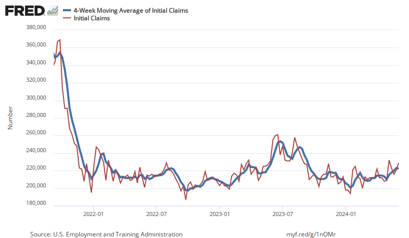
In the week ending February 24, the advance figure for seasonally adjusted initial unemployment claims 4-week moving average was 212,500, a decrease of 3,000 from the previous week’s revised average. The previous week’s average was revised up by 250 from 215,250 to 215,500.

The Pending Home Sales Index (PHSI)* – a forward-looking indicator of home sales based on contract signings – in January 2024 was down 8.8% year-over-year. NAR Chief Economist Lawrence Yun stated:

The job market is solid, and the country’s total wealth reached a record high due to stock market and home price gains. This combination of economic conditions is favorable for home buying. However, consumers are showing extra sensitivity to changes in mortgage rates in the current cycle, and that’s impacting home sales.

The latest Chicago Purchasing Manager’s Index (Chicago Business Barometer) fell to 44.0 in February 2024 from 46.0 in January. This index is used by the markets as a peak into the Purchasing Manager’s Index which will be released tomorrow.

Here is a summary of headlines we are reading today:

  • Low-Cost Nickel from Indonesia is Flooding The Market
  • New Tech Enhances Safety and Performance of Lithium Ion Batteries
  • Utility Scale Solar Installations Saw Largest Jump Ever Last Year
  • Can Anything Stop Bitcoin’s Bull Run?
  • Analysts Expect Oil Prices to Remain Close to $80 This Year
  • S&P 500 and Nasdaq rise Thursday as stocks head for a winning month: Live updates
  • Key Fed inflation measure rose 0.4% in January as expected, up 2.8% from a year ago
  • Ray Dalio says the U.S. stock market ‘doesn’t look very bubbly’
  • Solana soars more than 12% amid broader crypto rally: CNBC Crypto World
  • Feb Auto Sales: Here’s what to expect from Maruti, Tata Motors & other top automakers

Click on the “Read More” below to access these, other headlines, and the associated news summaries moving the markets today.