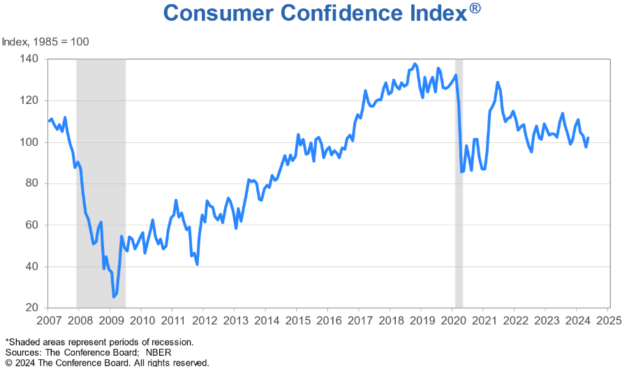
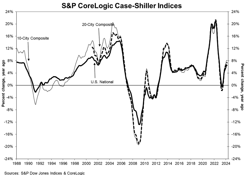
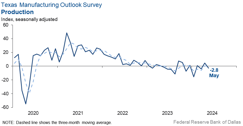
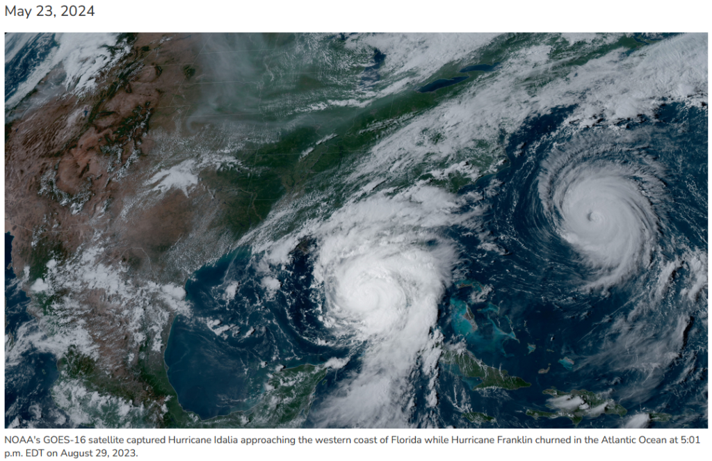
15 May 2024 Market Close & Major Financial Headlines: Markets Gapped Up At The Opening Bell Recording New Historic Highs For The Three Major Indexes, All Closing At Session Highs

Summary Of the Markets Today:

  • The Dow closed up 350 points or 0.88%, ( New high 39,935)
  • Nasdaq closed up 1.49%, ( New high 16.750)
  • S&P 500 closed up 1.17%, ( New high 5,312)
  • Gold $2,393 up $32.70,
  • WTI crude oil settled at $79 up $0.84,
  • 10-year U.S. Treasury 4.346 down 0.099 points,
  • USD index $104.32 down $0.69,
  • Bitcoin $65,813 up $4,252 (6.91%), – Historic high 73,798.25

*Stock data, cryptocurrency, and commodity prices at the market closing.


Click here to read our current Economic Forecast – May 2024 Economic Forecast: No Real Change So Expect The Economy To Continue To Plod Along


Today’s Economic Releases Compiled by Steven Hansen, Publisher:

Advance estimates of U.S. retail and food services sales for April 2024 was up 3.0% above April 2023 – 1.8% year-over-year inflation adjusted. This shows the economy is muddling along – and retail sales is not driving a stronger economy. Growth this month is average for the past 12 months.

The Consumer Price Index for All Urban Consumers (CPI-U) over the last 12 month increased 3.4% – down from last month’s 3.5% year-over-year growth. The index for shelter rose in April, as did the index for gasoline. Combined, these two indexes contributed heavily to inflation. The all items less food and energy index rose 3.6% over the last 12 months. The energy index increased 2.6% for the 12 months ending April. The food index increased 2.2% over the last year. The Federal Reserve prefers to use the inflation index associated with the BEA’s consumer spending.

The May 2024 Empire State Manufacturing Survey shows the headline general business conditions index was little changed at -15.6. New orders declined significantly, while shipments held steady. Unfilled orders continued to decline. Delivery times shortened, and inventories were little changed. Labor market conditions remained weak, with employment and hours worked continuing to move lower. The pace of input and selling price increases moderated slightly. Though firms expect conditions to improve over the next six months, optimism was subdued.

Here is a summary of headlines we are reading today:

Click on the “Read More” below to access these, other headlines, and the associated news summaries moving the markets today.


Today Through the Fourth Friday (22 to 28 days) Weather Outlook for the U.S. and a Six-Day Forecast for the World: posted May 15, 2024

This article focuses on what we are paying attention to in the next 48 to 72 hours. The article also includes weather maps for longer-term U.S. outlooks and a six-day World weather outlook which can be very useful for travelers.

First the NWS Short Range Forecast. The afternoon NWS text update can be found here but it is unlikely to have changed very much. The images in this article automatically update.

Short Range Forecast Discussion
NWS Weather Prediction Center College Park MD
Wed May 15 2024
Valid 12Z Wed May 15 2024 – 12Z Fri May 17 2024

…Unsettled weather spreads into parts of the Midwest, Mid-Atlantic, and
Southeast today…

…Hazardous heat possible across South Florida and South Texas this week

…Significant flash flooding possible across portions of East Texas and
Louisiana on Thursday…

Showers and thunderstorms will continue to move through the eastern U.S.
ahead of an advancing low pressure system lifting through the Tennessee
Valley/Mid-Atlantic region and a slow moving cold front through the
Northeast. Showers and thunderstorms will also be ushered into the Plains
along and ahead of a cold front. Some of these storms may have the
potential to become severe and possibly produce areas of excessive
rainfall through Thursday morning. SPC has an Enhanced Risk for sever
weather for the Texas Panhandle and portions of Oklahoma and southern
Kansas with Slight Risks for the Carolinas and central Florida. Across
South Florida, persistent southwesterly winds ahead of an approaching
mid-level ridge axis will set the stage for very warm weather, with heat
indices exceeding 100 degrees possible. Localized Major heat-related
impacts are possible with this round of hot weather through the work week
according to experimental NWS HeatRisk guidance. Hazardous heat also will
build into South Texas today and Thursday as a warm front returns
northward from the Gulf of Mexico, ushering in a very warm and moist
airmass into the region.

With the return of the heat there will also be an environment that will be
very conducive for widespread heavy rainfall for the Gulf Coast, Southern
Plains and Lower/Mid-Mississippi Valley which could be a potentially
significant heavy rain event. SPC has a Slight Risk in place across the
South and WPC has a Moderate (Level 3 out of 4) for excessive rainfall for
eastern Texas and Louisiana. Areal averages of 2 to 4 inches is forecast
for the western Gulf states and locally higher amounts will be possible.
Over the past 2 weeks there has been a near continuous stream of heavy
rainfall which has made much of this part of the region sensitive to any
additional rain.

To get your local forecast plus active alerts and warnings click HERE and enter your city, state or zip code.

Learn about wave patterns HERE.

Then, looking at the world and of course, the U.S. shows here also. Today we are looking at precipitation.

Please click on “Read More” below to access the full Daily Report issued today.

14 May 2024 Market Close & Major Financial Headlines: Markets Opened Fractionally Higher, But Searched For Direction Before Finally Trending Upward In The Green Where The Three Major Indexes Close Near Session Highs

Summary Of the Markets Today:

  • The Dow closed up 127 points or 0.32%,
  • Nasdaq closed up 0.75%,
  • S&P 500 closed up 0.48%,
  • Gold $2,362 up $18.90,
  • WTI crude oil settled at $78 down $0.99,
  • 10-year U.S. Treasury 4.449 down 0.032 points,
  • USD index $105.02 down $0.20,
  • Bitcoin $61,547 down $1,500 (2.38%)

*Stock data, cryptocurrency, and commodity prices at the market closing.


Click here to read our current Economic Forecast – May 2024 Economic Forecast: No Real Change So Expect The Economy To Continue To Plod Along


Today’s Economic Releases Compiled by Steven Hansen, Publisher:

NFIB’s Small Business Optimism Index rose by 1.2 points in April to 89.7, marking the first increase of this year but the 28th consecutive month below the 50-year average of 98. Twenty-two percent of owners reported that inflation was their single most important problem in their business, down three points from March but still the number one problem for small business owners. Bill Dunkelberg, NFIB Chief Economist stated:

Cost pressures remain the top issue for small business owners, including historically high levels of owners raising compensation to keep and attract employees. Overall, small business owners remain historically very pessimistic as they continue to navigate these challenges. Owners are dealing with a rising level of uncertainty but will continue to do what they do best – serve their customers.

Inflation continued in the Producer Price Index which was 2.2% year-over-year in April 2024 – up from 1.8% in March. Growth continued in both services and goods in the PPI. Tomorrow, the Consumer Price Index for April will be released with our estimate being 3.6% year-over-year (and the market consensus is 3.4% year-over-year.

Here is a summary of headlines we are reading today:

Click on the “Read More” below to access these, other headlines, and the associated news summaries moving the markets today.

Today Through the Fourth Friday (22 to 28 days) Weather Outlook for the U.S. and a Six-Day Forecast for the World: posted May 14, 2024

This article focuses on what we are paying attention to in the next 48 to 72 hours. The article also includes weather maps for longer-term U.S. outlooks and a six-day World weather outlook which can be very useful for travelers.

First the NWS Short Range Forecast. The afternoon NWS text update can be found here but it is unlikely to have changed very much. The images in this article automatically update.

Short Range Forecast Discussion
NWS Weather Prediction Center College Park MD
Tue May 14 2024
Valid 12Z Tue May 14 2024 – 12Z Thu May 16 2024

…Severe thunderstorms and flash flooding will impact portions of the
Gulf Coast and the Southeast on Tuesday…

…Above-average temperatures expected for South Florida and the West…

Wet and unsettled weather is in store for the Gulf Coast and Southeast
today thanks to a slow-moving frontal boundary. Showers and thunderstorms
across this region have the potential to turn severe and will be capable
of producing heavy rain. SPC has a Slight Risk for severe weather,
indicating the potential exists for multiple corridors of damaging winds,
very large hail, and a one or two tornadoes covering central/northern
Florida and southern Georgia. Additionally, WPC has a Slight Risk for
excessive rainfall and local flash flooding highlighted for much of the
same area as the severe weather threat while a broader Marginal Risk spans
northward to the Ohio Valley and Mid-Atlantic regions. As the system
advances eastward the threats for severe storms and heavy rainfall will
reduce for Wednesday to a Marginal Risk.

Showers and storms over the lower Missouri an Mid-Mississippi valleys to
the Ohio Valley will spread east through the Mid-Atlantic and the
Northeast today. A brief window of drier weather over the Mississippi
Valley into early Wednesday will be followed by the next round of showers
and storms that will begin to spread into the region by late Wednesday.
Before impacting the central U.S. on Wednesday, this previously noted
system will spread showers and storms followed by much cooler temperatures
from the Northern Rockies into Central Rockies and High Plains on Tuesday.

South Florida will continue to have well above-normal, with near to record
high temperatures through Wednesday. Meanwhile, warmer temperatures will
spread across the western states reaching well-above normal highs across
the region by midweek.

To get your local forecast plus active alerts and warnings click HERE and enter your city, state or zip code.

Learn about wave patterns HERE.

Then, looking at the world and of course, the U.S. shows here also. Today we are looking at precipitation.

Please click on “Read More” below to access the full Daily Report issued today.

13May2024 Market Close & Major Financial Headlines: DOW Has First Loss In A Week Which Pundits Attribute To Increasing Inflation Fears

Summary Of the Markets Today:

  • The Dow closed down 81 points or 0.21%,
  • Nasdaq closed up 0.29%,
  • S&P 500 closed down 0.02%,
  • Gold $2,343 down $32.10,
  • WTI crude oil settled at $79 up $0.92,
  • 10-year U.S. Treasury 4.485% down 0.019 points,
  • USD index $105.23 down $0.07,
  • Bitcoin $63,127 up $1,675,

*Stock data, cryptocurrency, and commodity prices at the market closing.


Click here to read our current Economic Forecast – May 2024 Economic Forecast: No Real Change So Expect The Economy To Continue To Plod Along


Today’s Economic Releases Compiled by Steven Hansen, Publisher:

No releases today

Here is a summary of headlines we are reading today:

  • $7.5 Billion Bipartisan Investment Nets Only 7 EV Charging Stations
  • Oil Prices Rise as Market Anticipates OPEC Monthly Report
  • EU Unleashes Sweeping Sanctions Against Moscow and Minsk
  • Nigeria to Boost Oil Production by 40,000 Bpd as New Field Starts Up
  • Chevy Malibu Discontinued as Company Transitions to EVs
  • Memorial Day Travel Expected to Near Record High
  • China Hikes Natural Gas and Coal Imports as Prices Halve From 2023
  • Google and Apple partner to fight location tracker stalking
  • Turkey Treating Over 1,000 Wounded Hamas Members In Hospitals: Erdogan

Click on the “Read More” below to access these, other headlines, and the associated news summaries moving the markets today.

Today Through the Fourth Friday (22 to 28 days) Weather Outlook for the U.S. and a Six-Day Forecast for the World: posted May 13, 2024

This article focuses on what we are paying attention to in the next 48 to 72 hours. The article also includes weather maps for longer-term U.S. outlooks and a six-day World weather outlook which can be very useful for travelers.

First the NWS Short Range Forecast. The afternoon NWS text update can be found here but it is unlikely to have changed very much. The images in this article automatically update.

Short Range Forecast Discussion
NWS Weather Prediction Center College Park MD
Mon May 13 2024
Valid 12Z Mon May 13 2024 – 12Z Wed May 15 2024

…Severe thunderstorms and flash flooding will impact portions of the
Gulf Coast today and the Southeast Tuesday…

…Above average temperatures expected for the West…

A strong upper low will push east across the central U.S. today
accompanied by a strengthening surface low pressure system that will sweep
across the southern tier. A warm front will lift north across the Gulf
Coast ahead of the system and prime the environment for showers and
thunderstorms today. Severe thunderstorms are expected from central and
east Texas across portions of the Gulf Coast states to the Florida
Panhandle, and the Storm Prediction Center Convective Outlook highlights
this area with a Slight Risk (level 2/5) of Severe Thunderstorms with an
embedded Enhanced Risk (level 3/5) area. Potential storm hazards will
include significant wind gusts, very large hail, and a few tornadoes.
Additionally, anomalous moisture and high instability over the Gulf Coast
region will support waves of very heavy rainfall that will likely lead to
scattered to numerous instances of flash flooding. There is Slight Risk
(level 2/4) of Excessive Rainfall in effect from east Texas across
southern portions of the Gulf Coast states to the Florida Panhandle and a
Moderate Risk (level 3/4) in effect from the toe of the Louisiana boot to
the western Florida Panhandle. Heavy rainfall will also be possible
further north in parts of the Mid-Mississippi Valley and Upper Midwest
along a slow moving frontal boundary draped over the top of the southern
low pressure system.

The low pressure system will continue to move east through mid-week, and
the warm front will lift north across the Southeast while the trailing
cold front moves across the Lower Mississippi Valley on Tuesday.
Widespread showers and thunderstorms are forecast to develop across the
eastern U.S. on Tuesday, and although the severe thunderstorm threat will
be lower than it was on Monday, isolated severe storms with heavy rainfall
will be possible in the Southeast. By Tuesday night, showers and storms
will expand into the northeast as well, then the southern low pressure
system will push into the Atlantic on Wednesday.

Unsettled weather is also expected to develop in the Intermountain West
and the northern and central Plains as a frontal system moves south across
the region over the next few days. Low pressure will consolidate and
strengthen over the northern/central Plains on Tuesday and move towards
the Mississippi Valley on Wednesday, and this system will create chances
for showers and thunderstorms and high elevation snow.

Temperature-wise, highs will be generally above average for much of the
western third of the U.S. through mid-week, but cooler air will move into
the northern and central Rockies Tuesday into Wednesday in the wake of a
frontal system. Above average temperatures are also forecast for the
northern Plains, Great Lakes, and Ohio Valley today, but temperatures will
return to near average or dip slightly below average Tuesday and
Wednesday. Temperatures will be slightly below to near average for the
rest of the central and eastern U.S. with the exception of parts of
southern Texas and central and south Florida where temperatures will
remain above average. High temperatures in these areas will be in the 90s
and lower 100s, and some daily high temperature records may be tied or
broken.

To get your local forecast plus active alerts and warnings click HERE and enter your city, state or zip code.

Learn about wave patterns HERE.

Then, looking at the world and of course, the U.S. shows here also. Today we are looking at precipitation.

Please click on “Read More” below to access the full Daily Report issued today.

Today Through the Fourth Friday (22 to 28 days) Weather Outlook for the U.S. and a Six-Day Forecast for the World: posted May 12, 2024

This article focuses on what we are paying attention to in the next 48 to 72 hours. The article also includes weather maps for longer-term U.S. outlooks and a six-day World weather outlook which can be very useful for travelers.

First the NWS Short Range Forecast. The afternoon NWS text update can be found here but it is unlikely to have changed very much. The images in this article automatically update.

Short Range Forecast Discussion
NWS Weather Prediction Center College Park MD
Sun May 12 2024
Valid 12Z Sun May 12 2024 – 12Z Tue May 14 2024

…Heavy rain and severe thunderstorm chances extend from the southern
Plains to the lower Mississippi Valley and Southeast over the next few
days…

…Well above average temperatures expected throughout the West and
north-central United States…

Active weather is in the forecast for the southern U.S. over the next few
days as a low pressure system sweeps across the South into the Southeast.
A potent upper low will move over the Plains today, and low pressure will
deepen in the lee of the Rockies. The stalled frontal boundary across West
Texas and New Mexico will lift northeast as a warm front, and warm, moist
Gulf air will surge into the central/southern Plains and lower Mississippi
Valley. Widespread showers and thunderstorms are expected, and conditions
will be favorable for scattered strong to severe storms from eastern Texas
through central Louisiana. The Storm Prediction Center has issued a Slight
Risk of Severe Thunderstorms (level 2/5) for this area. Potential storm
hazards include large hail, damaging winds, and a couple tornadoes. In
addition to severe storm hazards, heavy rain falling on top of saturated
soils will likely lead to flash flooding. There is a Slight Risk of
Excessive Rainfall (level 2/4) in effect from eastern Texas into the lower
Mississippi Valley with an embedded Moderate Risk (level 3/4) area for
particularly sensitive areas in east Texas and western Louisiana. The low
pressure system will push eastwards this week, and the threat of severe
thunderstorms and heavy rainfall/flash flooding will shift across the
northern Gulf Coast to the Southeast.

To the north, a front moving south across the Upper Midwest and Great
Lakes region will produce showers and thunderstorms today and Monday, and
precipitation will push into the Northeast Tuesday. Precipitation chances
will also expand across the Mid-Atlantic on Tuesday ahead of the southern
low pressure system. In the northern Rockies and northern Plains, a
separate frontal system will be moving south across the region Monday into
Tuesday, and low elevation showers and storms and high elevation snow are
expected. Elsewhere, mostly dry weather is expected through Tuesday for
the West Coast and Southwest.

Summer-like temperatures will continue today across much of the West and
north-central U.S. with well-above average highs in the 70s and 80s, and
potentially the lower 90s for some. Below average temperatures are
forecast today for the rest of the central U.S. and much of the East
Coast. Temperatures will remain above average in the West through Tuesday,
but will begin to return to near normal Monday and Tuesday for the central
and eastern United States.

To get your local forecast plus active alerts and warnings click HERE and enter your city, state or zip code.

Learn about wave patterns HERE.

Then, looking at the world and of course, the U.S. shows here also. Today we are looking at precipitation.

Please click on “Read More” below to access the full Daily Report issued today.

Comparing Two Data Organizations for Federal Deficit Spending vs Inflation. Part 2

Two studies have been performed on the correlations between U.S. Federal Deficit Spending and CPI Inflation. The first used federal deficits for fiscal years between 1914 and 2022. The second study used the quarterly data available for federal deficit spending starting in 1966.  This article is the second to compare the results of the two studies.


Photo by Adi Goldstein on Unsplash

Heat Stress Impact on Coral Reefs in the Florida Keys and The Future of Restoration – Posted on May 11, 2024

I do not think we have talked about Ocean Heat Stress before but it is important.

I swapped out the map in this article with another map from a prior article by this author.

 I have not had to give readers a warning before but some of the photography might be upsetting. It should be upsetting. The major problem with Global Warming and in this case, the warming of oceans is that Darwin works at one speed and our current rate of Warming exceeds the speed of adaptation.  But in the article, a way to assist the survival of the fittest is discussed.

Some Readers may have to click on “Read More” to access the rest of this action-packed article and access the two YouTubes.

Today Through the Fourth Friday (22 to 28 days) Weather Outlook for the U.S. and a Six-Day Forecast for the World: posted May 11, 2024

This article focuses on what we are paying attention to in the next 48 to 72 hours. The article also includes weather maps for longer-term U.S. outlooks and a six-day World weather outlook which can be very useful for travelers.

First the NWS Short Range Forecast. The afternoon NWS text update can be found here but it is unlikely to have changed very much. The images in this article automatically update.

Short Range Forecast Discussion
NWS Weather Prediction Center College Park MD
Sat May 11 2024
Valid 12Z Sat May 11 2024 - 12Z Mon May 13 2024

...Wet weekend in store for the Central/Southern Plains and adjacent
Rockies...

...Heavy rainfall and flash flooding possible for parts of the South and
Southeast Sunday through Tuesday...

...Above average temperatures forecast for the West and north-central U.S.
this weekend...

Precipitation chances will continue today for portions of the
central/southern Plains and adjacent Rockies, and coverage is expected to
increase with widespread showers and thunderstorms forecast to impact the
Plains today. Locally heavy rainfall and isolated severe thunderstorms
will be possible east of a stalled frontal boundary draped up against the
Rockies. Potential storm hazards will include hail, strong wind gusts, and
isolated flash flooding. In the higher elevations west of the frontal
boundary, wintry precipitation is expected, and some of the higher peaks
in Colorado and northern New Mexico could receive a few additional inches
of snow.

The surface front is expected to remain in place through tonight, then the
front will begin to lift north as a warm front across Texas and the Lower
Mississippi Valley on Sunday while low pressure deepens over the Plains.
Another round of widespread showers and thunderstorms will develop on
Sunday, and the threat of heavy rainfall will increase as warm Gulf air
moves into the region. There is a Slight Risk of Excessive Rainfall (level
2/4) from central Texas east to the Mississippi River. Scattered instances
of flash flooding will be possible, especially where soils are still moist
after recent heavy rains. The developing low pressure system is forecast
to push east across the Lower Mississippi Valley towards the Southeast on
Monday and Tuesday, and the heavy rainfall/flash flood threat will shift
east across the northern Gulf Coast states.

To the east, precipitation chances will return to the Mid-Atlantic and
Great Lakes regions today as an occluded frontal system pushes towards the
East Coast. Showers and thunderstorms will linger into Sunday morning
before the system moves offshore Sunday afternoon. Another frontal system
will drop south into the north-central U.S. over the weekend, which may
renew precipitation chances near the western Great Lakes on Sunday. Other
areas of the country should remain mostly dry through Monday.

Upper-level ridging over the West Coast and north-central U.S. will lead
to well-above average temperatures in these regions through the weekend.
High temperatures this afternoon will range from the 80s to lower 90s in
California and the Pacific Northwest and from the 70s to lower 80s in the
northern Plains. The focus for warmer temperatures will shift more into
the Interior West/Great Basin and Upper Midwest on Sunday. Below average
temperatures are forecast elsewhere across the eastern and central U.S.
through the weekend, but temperature will trend back towards normal early
in the work week.

To get your local forecast plus active alerts and warnings click HERE and enter your city, state or zip code.

Learn about wave patterns HERE.

Then, looking at the world and of course, the U.S. shows here also. Today we are looking at precipitation.

Please click on “Read More” below to access the full Daily Report issued today.