11 SEPT 2024 Market Close & Major Financial Headlines: Markets Battled Core Inflation Numbers After Opening Deep Into The Red For The Small Caps To Finally Close Strongly Higher In The Green

Summary Of the Markets Today:

  • The Dow closed up 125 points or 0.31%,
  • Nasdaq closed up 2.17%,
  • S&P 500 closed up 1.07%,
  • Gold $2,541 up $2.00,
  • WTI crude oil settled at $67 up $1.40,
  • 10-year U.S. Treasury 3.661 up 0.017 points,
  • USD index $101.72 up $0.09,
  • Bitcoin $57,647 up $70 or 0.12%,

*Stock data, cryptocurrency, and commodity prices at the market closing

Today’s Highlights

The U.S. stock market closed higher on Wednesday after initially falling, as investors processed the August inflation report and the first presidential debate between Donald Trump and Kamala Harris. Nvidia led the tech rally, with shares surging over 8% Inflation. Inflation fell to a more than three-year low. Core inflation (excluding food and gas) rose 0.3% month-over-month, higher than the expected 0.2% The higher core inflation reading reduced expectations for a larger Fed rate cut. Odds of a 50 basis point rate cut at the next Fed meeting dropped to 15%, down from 44% a week ago. Markets now favor a smaller 25 basis point cut. Investors analyzed the Trump-Harris presidential debate, which provided limited detail on market-moving economic issues. GameStop shares fell almost 12% after missing quarterly revenue expectations. Oil prices rebounded from three-year lows, with WTI and Brent crude both rising about 2%.


Click here to read our current Economic Forecast – September 2024 Economic Forecast: One Recession Flag Removed With Three Remaining


Today’s Economic Releases Compiled by Steven Hansen, Publisher:

The Consumer Price Index for All Urban Consumers (CPI-U) rose 2.5% for the 12 months ending August 2024 (down from last month’s 2.9%), the smallest 12-month increase since February 2021. The all items less food and energy index rose 3.2% year-over-year (unchanged from last month). The energy index decreased 4.0 percent for the 12 months ending August. The food index increased 2.1% over the last year. The primary reason for the decline of the CPI-U was energy which declined 10.1% year-over-year. Over the years I have done several detailed analysis of the CPI and my conclusion is that inflation is different for each of us depending on how money is spent. The CPI shows food is up only 0.9% year-over-year – I am seeing food up 5%+ (see the table below for the 12 month change in the components of the CPI).

Un-adjusted 12-mos. ended Aug. 2024
All items 2.5
Food 2.1
Food at home 0.9
Food away from home(1) 4.0
Energy -4.0
Energy commodities -10.1
Gasoline (all types) -10.3
Fuel oil -12.1
Energy services 3.1
Electricity 3.9
Utility (piped) gas service -0.1
All items less food and energy 3.2
Commodities less food and energy commodities -1.9
New vehicles -1.2
Used cars and trucks -10.4
Apparel 0.3
Medical care commodities(1) 2.0
Services less energy services 4.9
Shelter 5.2
Transportation services 7.9
Medical care services 3.2


Here is a summary of headlines we are reading today:

  • Oil Markets Are Ignoring Imminent Production Cuts By 3 OPEC+ Members
  • China’s Carbon Trading Market to Encompass Steel and Aluminum Sectors
  • Oil Prices Jump 3% as Hurricane Takes 675,000 bpd Offline in the Gulf of Mexico
  • Goldman Sachs: RBOB Gasoline Sees Open Interest Surge As Storm Looms
  • U.S. Inflation Cooled in August Thanks to Lower Energy Prices
  • Study Claims Banks ‘Greenlaunder’ Trillions of Dollars of Fossil Fuels Funding
  • S&P 500 rises, Nasdaq closes 2% higher in rebound from inflation report rout: Live updates
  • Here’s the inflation breakdown for August 2024 — in one chart
  • Bitcoin could soon hit six figures regardless of who wins U.S. election, investors say
  • Hurricane Francine takes aim at the Louisiana coast amid fears of storm surge and flooding
  • Uranium Stocks Ignite After Putin Asks Gov’t To Weigh Export Restrictions On Critical Commodities
  • Treasury yields bounce off 2024 lows after August CPI inflation report

Click on the “Read More” below to access these, other headlines, and the associated news summaries moving the markets today.

Today Through the Fourth Friday (22 to 28 days) Weather Outlook for the U.S. and a Six-Day Forecast for the World: posted September 11, 2024

This article focuses on what we are paying attention to in the next 48 to 72 hours. The article also includes weather maps for longer-term U.S. outlooks and a six-day World weather outlook which can be very useful for travelers.

First the NWS Short Range Forecast. The afternoon NWS text update can be found here after about 4 p.m. New York time but it is unlikely to have changed very much from the morning update. The images in this article automatically update.

Short Range Forecast Discussion
NWS Weather Prediction Center College Park MD
Wed Sep 11 2024
Valid 12Z Wed Sep 11 2024 – 12Z Fri Sep 13 2024

…Hurricane Francine is forecast to make landfall in Louisiana later this
evening with damaging winds, life-threatening storm surge, and torrential
rainfall…

…A round of moderate to heavy rain with high-elevation snow forecast
throughout the northern Rockies…

…Elevated to critical fire weather concerns across much of the Great
Basin and portions of the High Plains…

Ample attention is on the central Gulf Coast today as Hurricane Francine
is anticipated to make landfall in Louisiana this evening before spreading
impacts north to the Mid-South through the end of the week. Once the storm
pushes onshore south-central Louisiana tonight, life-threatening weather
conditions are expected to impact parts of the state, including the cites
of Lafayette, Baton Rouge, and New Orleans. Hazardous weather conditions
include storm surge, strong winds, torrential rainfall, and a few
tornadoes. While the strongest winds and peak storm surge are expected to
occur closer to the center of Francine in south-central portions of
Louisiana, the heavy rain and tornado threats are forecast to span much
farther east along the central and eastern Gulf Coast, including southern
Mississippi, Alabama, and the Florida Panhandle. In total, Francine is
expected to produce rainfall amounts of 4 to 8 inches, with local amounts
to 12 inches for the central/eastern Gulf Coast through Thursday night.
This rainfall could lead to considerable flash and urban flooding. As
Francine pushes northward into the Mid-South and weakens by the end of the
week, additional heavy rain is possible and could lead to scattered
instances of flash flooding. Additionally, a lingering frontal boundary
draped across the Florida Peninsula could lead to localized flash flooding
concerns over the next few days. Residents under hurricane-related
warnings should follow advice of local officials, including evacuation
orders, and never drive across flooded roadways.

A separate weather system will also impact the Nation through the end of
this week, with moderate to heavy rain and gusty winds impacting parts of
the Intermountain West and northern Rockies. This autumn storm will be
driven by a deep upper low crossing from the Northwest today before
closing-off and churning over the northern Rockies on Thursday. Most of
the impactful precipitation will be confined to the northern Rockies and
the High Plains on Montana. A few inches of rainfall could produce
flooding concerns throughout northwest Montana, prompting a Slight Risk
(level 2/4) of Excessive Rainfall both today and Thursday. Snow levels
dropping to around 7,000-8000 feet may also create hazardous winter-like
conditions for the high elevations of Montana Idaho, and northwest
Wyoming. The other aspect of this system will be associated with gusty
winds and increased fire weather concerns throughout the Great Basin and
High Plains. Strong winds combined with dry vegetation and low relative
humidity are forecast to be more pronounced over the Great Basin today and
increase the chances for erratic fire behavior. Additionally, elevated to
critical fire weather also exists across the High Plains and is most
apparent on Thursday as southerly winds increase in speed. Red Flag
Warnings and Fire Weather Watches have been issued throughout 10 states
between California and Nebraska. Outdoor burning is not recommended
throughout these regions and residents are reminded to not go near any
wildfires as they can spread quickly.

Otherwise, a large high pressure system over the Northeast will aid in
producing tranquil weather from the Great Lakes to much of the East. Well
above average temperatures are expected to overspread the north-central
U.S. before a warming trend is also noticeable across the southern Plains
by Friday. Highs across the northern Plains, Upper Midwest, and Great
Lakes are forecast to reach into the upper 80s and low 90s, while upper
90s eventually return to the western half of Texas and eastern New Mexico.

cone graphic

To get your local forecast plus active alerts and warnings click HERE and enter your city, state or zip code.

Learn about wave patterns HERE.

Then, looking at the world and of course, the U.S. shows here also. Today we are looking at precipitation.

Please click on “Read More” below to access the full Daily Report issued today.

10 SEPT 2024 Market Close & Major Financial Headlines: Small Caps Lead The Markets Higher While The Dow Closes Moderately Lower

Summary Of the Markets Today:

  • The Dow closed down 93 points or 0.23%,
  • Nasdaq closed up 0.84%,
  • S&P 500 closed up 0.45%,
  • Gold $2,545 up $12.60,
  • WTI crude oil settled at $66 down $2.52,
  • 10-year U.S. Treasury 3.646 down 0.053 points,
  • USD index $101.62 up $0.07,
  • Bitcoin $57,839 up $834 or 0.46%,

*Stock data, cryptocurrency, and commodity prices at the market closing

Today’s Highlights

U.S. stock markets experienced a mixed performance in a volatile trading session on Tuesday as investors anticipated a crucial consumer inflation report on Wednesday. This report is seen as key to determining the timing and size of potential interest rate cuts by the Federal Reserve.

JPMorgan Chase shares dropped about 5% after warning that forecasts for net interest income were too high, weighing on the Dow. Brent crude dropped below $70 per barrel, reaching its lowest level since December 2021. The decline followed OPEC’s lowered demand growth forecast for 2024 and 2025. Apple shares edged lower after losing an EU court battle over a $14 billion tax bill. Oracle stock jumped more than 10% following strong earnings, driven by cloud services demand.

Markets are also anticipating the first presidential debate between Donald Trump and Kamala Harris on tonight. The market’s volatility reflects investors’ uncertainty, balancing hopes for significant rate cuts against concerns about potential recession risks.


Click here to read our current Economic Forecast – September 2024 Economic Forecast: One Recession Flag Removed With Three Remaining


Today’s Economic Releases Compiled by Steven Hansen, Publisher:

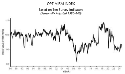
The NFIB Small Business Optimism Index fell by 2.5 points in August 2025 to 91.2, erasing all of July’s gain. This is the 32nd consecutive month below the 50-year average of 98. The Uncertainty Index rose to 92, its highest level since October 2020. Inflation remains the top issue among small business owners, with 24% of owners reporting it as their top small business operating issue, down one point from July. NFIB Chief Economist Bill Dunkelberg added:

The mood on Main Street worsened in August, despite last month’s gains. Historically high inflation remains the top issue for owners as sales expectations plummet and cost pressures increase. Uncertainty among small business owners continues to rise as expectations for future business conditions worsen.

Here is a summary of headlines we are reading today:

  • WTI Oil Price Hits 3-Year Low Ahead of Trump-Harris Showdown
  • Falling Chinese Steel Prices Send Ripples Through Global Markets
  • Oil Prices Drop 4.5% On Record-Bearish Sentiment from Money Managers
  • European Natural Gas Prices Drop as Wind Power Soars
  • Futures Prices Point to Spike in U.S. Natural Gas Prices in 2025
  • Two key inflation reports this week will help decide the size of the Fed’s interest rate cut
  • JPMorgan Chase shares drop 5% after bank tempers guidance on interest income and expenses
  • Crypto will be ‘big boon’ for financial services over time, Robinhood CEO says: CNBC Crypto World
  • Jamie Dimon says ‘the worst outcome is stagflation,’ a scenario he’s not taking off the table
  • Volkswagen Declares War On Unions, Scraps Three-Decade-Old Job Protections
  • Americans Lost $5.6 Billion In Cryptocurrency Scams Last Year, FBI Says
  • Biden’s FAA Punishes SpaceX, Delays Starship Rocket Launch By Months
  • Falling oil prices and China concerns add fuel to market fears of a U.S. recession
  • Treasury yields establish fresh 2024 lows amid persistent recession worries

Click on the “Read More” below to access these, other headlines, and the associated news summaries moving the markets today.

Today Through the Fourth Friday (22 to 28 days) Weather Outlook for the U.S. and a Six-Day Forecast for the World: posted September 10, 2024

This article focuses on what we are paying attention to in the next 48 to 72 hours. The article also includes weather maps for longer-term U.S. outlooks and a six-day World weather outlook which can be very useful for travelers.

First the NWS Short Range Forecast. The afternoon NWS text update can be found here after about 4 p.m. New York time but it is unlikely to have changed very much from the morning update. The images in this article automatically update.

Short Range Forecast Discussion
NWS Weather Prediction Center College Park MD
Tue Sep 10 2024
Valid 12Z Tue Sep 10 2024 – 12Z Thu Sep 12 2024

…Life-threatening storm surge and hurricane-force winds, as well as the
risk of considerable flash flooding are forecast across southern Louisiana
on Wednesday as Francine approaches…

…Heavy rain expected to impact parts of the northern Rockies by
midweek…

…Elevated to critical fire weather concerns across much of the
Intermountain West…

As of early this morning Tropical Storm Francine continues churning in the
western Gulf of Mexico just to the southeast of Brownsville, Texas and
moving on a gradual northward motion. Francine is forecast to strengthen
into a hurricane before an expected landfall in southern Louisiana on
Wednesday. As the system approaches the central Gulf Coast and eventually
pushes inland across Louisiana, an increased threat of life-threatening
storm surge, hurricane-fore winds, and considerable flash flooding is
anticipated. Rainfall amounts of 4 to 8 inches, with local amounts up to
12 inches are forecast across much of central/eastern Louisiana and
Mississippi through Thursday night. Francine is then forecast to continue
its trek northward into the Mid-South on Thursday, while quickly
weakening. However, additional heavy rainfall and flash flooding concerns
are possible into western Tennessee neighboring regions. A stationary
front extending eastward from the center of the storm over the next few
days will also focus areas of numerous, slow-moving thunderstorms capable
of containing intense rainfall rates between the Florida Peninsula and
central Gulf Coast. Residents are reminded to remain weather-ready and
never drive across flooded roadways.

The only other section of the Lower 48 expecting chances for heavy rain
through midweek are parts the northern Rockies as a deep upper-level low
crosses over the region. A few inches of rainfall throughout northwest
Montana could lead to an increased risk of flash flooding on Wednesday,
which has prompted a Slight Risk (level 2/4) of Excessive Rainfall. This
storm system will also produce gusty winds throughout the Intermountain
West and lead to fire weather concerns. Specifically, the Storm Prediction
Center has issued a Critical Fire Weather area for much of Nevada and
western Utah. Current and continued wildfire activity over the Great Basin
will further add to the smokey skies noticeable throughout the northern
Plains, Midwest, and parts of the Ohio/Tennessee valleys.

High temperatures will remain above average average and into potentially
dangerous levels across parts of southern California and the Southwest
today before a quick cooldown commences by midweek. Meanwhile, upper
ridging in the north-central U.S. is expected to produce more summer-like
afternoon temperatures into the upper 80s and low 90s as far north as the
northern Plains and Upper Midwest by Thursday. These temperatures equate
to around 10 to 20 degrees above average, but are not expected to break
many daily records.

cone graphic

To get your local forecast plus active alerts and warnings click HERE and enter your city, state or zip code.

Learn about wave patterns HERE.

Then, looking at the world and of course, the U.S. shows here also. Today we are looking at precipitation.

Please click on “Read More” below to access the full Daily Report issued today.

09 SEPT 2024 Market Close & Major Financial Headlines: Wall Street’s Main Indexes Rallied Today, Recovering Some Last Weeks Losses, Finally Closing Significantly Higher

Summary Of the Markets Today:

  • The Dow closed up 484 points or 1.20%,
  • Nasdaq closed up 1.16%,
  • S&P 500 closed up 1.16%,
  • Gold $2,534 up $9.20,
  • WTI crude oil settled at $69 up $0.88,
  • 10-year U.S. Treasury 3.706 down 0.004 points,
  • USD index $101.61 up $0.43,
  • Bitcoin $56,930 up $2,084 or 3.80%,

*Stock data, cryptocurrency, and commodity prices at the market closing

Today’s Highlights

U.S. stocks rebounded strongly on Monday following the S&P 500’s worst week since early 2023, as investors refocused on inflation data that could influence upcoming interest rate decisions. Leading sectors included Financials, Industrials, and Energy. Among large-cap stocks, Nvidia, Tesla, and Amazon were notable gainers. The market is weighing the possibility of a 25 or 50 basis point cut at the upcoming Fed meeting, with recent comments from officials seeming to favor a smaller 0.25% reduction. Tech sector developments: Apple’s annual product launch event, featuring the new iPhone 16 series and updates to other devices, garnered attention. Investors will be closely watching the consumer inflation report on Wednesday and the producer inflation report on Thursday. These will be the final inflation indicators before the Fed’s policy decision on September 18.


Click here to read our current Economic Forecast – September 2024 Economic Forecast: One Recession Flag Removed With Three Remaining


Today’s Economic Releases Compiled by Steven Hansen, Publisher:

July 2024 sales of merchant wholesalers were up 2.9% from the revised July 2023 level. Total inventories of merchant wholesalers were up 0.4% from the revised July 2023 level. The July inventories/sales ratio for merchant wholesalers, except manufacturers’ sales branches and offices, based on seasonally adjusted data, was 1.35. The July 2023 ratio was 1.38. Those that follow my narrative know there is a methodology issue with the data gathering in this sector – the boundaries of this sector are fuzzy and confused by horizontal integrations vs. vertical splits vs. outsourcing of services previously performed in house vs. integration of formerly outsourced .  The number of employees as increased 0.9% year-over-year in an industry that has a relatively high level of robotics. My bottom line is that this sector is not indicating a recession but there are issues preventing an accurate quantification of growth.

According to the Federal Reserve, “in July 2024, consumer credit increased at a seasonally adjusted annual rate of 6.0 percent. Revolving credit increased at an annual rate of 9.4 percent, while nonrevolving credit increased at an annual rate of 4.8 percent.” Consumer Credit only grew 1.9% year-over-year (the methodology used by the Fed to express annual growth as an extrapolation of the change in the rate of month-over-month growth) – and if one subtracts the rate of inflation, consumer credit growth is negative this month (red line on the graph below). Non-revolving credit (say student or car loans) only grew at 0.3% year-over-year but revolving credit (say credit cards) grew at 6.7% year-over-year. Note that in January 2023, revolving credit growth peaked at 15.5% year-over-year and has been declining ever since.

Here is a summary of headlines we are reading today:

  • Russia Is Losing Its Grip on Central Asia
  • Iran’s Missile Diplomacy Raises Stakes in Russia-Ukraine Conflict
  • Oil Giants Evacuate Gulf of Mexico Platforms Ahead of Developing Hurricane
  • Libyan Oil Shutdown Pushes Up U.S. Grades
  • Oil Trading Giant Trafigura Sees Brent Falling Below $70 Soon
  • Iraq Rejects U.S. Accusations of Enabling Iran Oil Smuggling
  • Here’s everything Apple just announced: iPhone 16, iPhone 16 Pro, Apple Watch Series 10, AirPods 4 and more
  • Dow closes nearly 500 points higher in rebound from Wall Street’s worst week of 2024: Live updates
  • Palantir soars 13% on software vendor’s inclusion in S&P 500
  • Big Lots files for bankruptcy protection, sells to private equity firm as it promises to keep offering ‘extreme bargains’
  • MicroStrategy’s Michael Saylor predicts bitcoin could hit $13 million by 2045: CNBC Crypto World
  • Austin Tells Zelensky: Long-Range Strikes in Russia Won’t Be A Game Changer
  • Why low gasoline prices shouldn’t be a ‘bragging point’ in presidential elections
  • 10-year Treasury yield ends at another 2023 low as August CPI looms

Click on the “Read More” below to access these, other headlines, and the associated news summaries moving the markets today.

Today Through the Fourth Friday (22 to 28 days) Weather Outlook for the U.S. and a Six-Day Forecast for the World: posted September 9, 2024

This article focuses on what we are paying attention to in the next 48 to 72 hours. The article also includes weather maps for longer-term U.S. outlooks and a six-day World weather outlook which can be very useful for travelers.

First the NWS Short Range Forecast. The afternoon NWS text update can be found here after about 4 p.m. New York time but it is unlikely to have changed very much from the morning update. The images in this article automatically update.

Short Range Forecast Discussion
NWS Weather Prediction Center College Park MD
Mon Sep 09 2024
Valid 12Z Mon Sep 09 2024 – 12Z Wed Sep 11 2024

…Heavy rain and a risk of flash flooding expected throughout much of the
Gulf Coast and Florida Peninsula into midweek…

…Potentially dangerous heat forecast across southern California and the
Southwest today…

…Elevated to critical fire weather concerns as well as Air Quality
Alerts remain across much of the Great Basin…

A stationary front extending from the Florida Peninsula through the
northern Gulf of Mexico along with a gradually organizing area of low
pressure in the southwest Gulf of Mexico (labeled Potential Tropical
Cyclone Six by the National Hurricane Center) will continue to produce
areas of heavy rain and the risk of flash flooding through midweek. For
today, the heaviest rainfall is anticipated over portions of southern
Texas, the central Gulf Coast, and much of the Florida Peninsula, mainly
associated with scattered showers and thunderstorms near the stationary
boundary. This may lead to isolated flash flooding concerns mainly
concentrated to urban locations. By Tuesday and more pronounced on
Wednesday, increased moisture content and organized bands of thunderstorms
associated with Potential Tropical Cyclone Six are forecast to reach the
western and central Gulf Coast. This will increase the risk of heavy
rainfall and considerable flash flooding. At the moment, the greatest risk
for rainfall amounts up to 12 inches and numerous flash floods are
forecast throughout southern Louisiana. Life-threatening storm surge and
damaging winds are also possible from the Upper Texas Coast to the
Louisiana coastline as the system is forecast to reach hurricane strength
in the northwest Gulf of Mexico by midweek. Residents should ensure they
have their hurricane plan in place and check www.nhc.noaa.gov for the
latest forecast.

Dangerous heat is in the forecast for at least one additional day for
southern California and parts of the Southwest. Highs into the upper 90s
and triple digits have prompted Excessive Heat Warnings and Heat
Advisories to be issued, with a cooling trend set to commence by midweek.
The combination of above average temperatures, dry vegetation, and gusty
winds have resulted in elevated to critical fire weather concerns
throughout much of the Intermountain West through the next couple of days.
Additionally, current wildfires continue to pump smoke into the atmosphere
of the northern Great Basin, leading to poor air quality. This smoke is
also forecast to extend eastward in the mid-to-upper levels of the
atmosphere through the northern Plains and Ohio Valley, creating
noticeably hazy skies.

Elsewhere, well above average temperatures are expected across the
north-central U.S. as highs return to the upper 80s and low 90s, which
equates to around 10-15 degrees above average. Cooler, fall-like
temperatures will kickoff the new workweek throughout the Ohio Valley and
East until temperatures return to near normal by Wednesday as the dominant
high pressure system in place slowly slides eastward to the western
Atlantic.

While notable precipiation should be mostly sparse across the Lower 48
outside of the Gulf Coast, a few areas of locally heavy rain are possible
across the Northeast and Northwest through Wednesday. Isolated severe
thunderstorms are possible throughout Upstate New York today as a weak
cold front dives across the region, with some storms potentially
containing damaging wind gusts. Increasing precipitation chances are also
forecast to spread into the Northwest and Northern Rockies as a deep upper
low swings eastward from the northeast Pacific.

cone graphic

To get your local forecast plus active alerts and warnings click HERE and enter your city, state or zip code.

Learn about wave patterns HERE.

Then, looking at the world and of course, the U.S. shows here also. Today we are looking at precipitation.

Please click on “Read More” below to access the full Daily Report issued today.

Declining Reservoir Reliability and Increasing Reservoir Vulnerability: Long-Term Observations Reveal Longer and More Severe Periods of Low Reservoir Storage for Major United States Reservoirs – Published on September 8, 2024

I am republishing this  Open Access article as I think this will be new information for EconCurrents.com readers. I have published related articles recently which can be accessed  HERE and HERE.

I have provided the below article in full but HERE is the link.  I have highlighted some statements and my comments are either  surrounded by  brackets []  or in  a text box

Citation: Simeone, C. E., Hammond, J. C., Archfield, S. A., Broman, D., Condon, L. E., Eldardiry, H., Olson, C. G., & Steyaert, J. C. (2024). Declining Reservoir Reliability and Increasing Reservoir Vulnerability: Long-Term Observations Reveal Longer and More Severe Periods of Low Reservoir Storage for Major United States Reservoirs. Geophysical Research Letters, 51(16), e2024GL109476. https://doi.org/10.1029/2024GL109476

Abstract

Hydrological drought is a pervasive and reoccurring challenge in managing water resources. Reservoirs are critical for lessening the impacts of drought on water available for many uses. We use a novel and generalized approach to identify periods of unusually low reservoir storage—via comparisons to operational rule curves and historical patterns—to investigate how droughts affect storage in 250 reservoirs across the conterminous U.S. (CONUS). We find that the maximum amount of water stored in reservoirs is decreasing, and that periods of unusually low storage are becoming longer, more severe, and more variable in (a) western and central CONUS reservoirs, and (b) reservoirs with primarily over-year storage. Results suggest that reservoir storage has become less reliable and more vulnerable to larger deviations from desired storage patterns. These changes have coincided with ongoing shifts to the hydroclimate of CONUS, and with sedimentation further reducing available reservoir storage. [Editor’s Note: Drought is natural.  It is an error to asume that a period of drought is due to a changing hydroclimate. It may be or may not be. It just as well be the combination of the phases of the Ocean Cycles. To the extent that  drought is caused by warmer temperatures we have a a better basis for attributing it to Global Warming. Same goes  for increased evaporation from reservoirs.]

Key Points

  • Low-storage periods are longer, more severe, and more variable in over-year storage reservoirs and in the western and central CONUS
  • Longer periods of low storage for some regions in recent years suggests decreased reservoir reliability in a changing hydroclimate
  • Maximum annual storage is also declining across CONUS, furthered by storage losses from sedimentation

Plain Language Summary

Drought in water systems is a major challenge in managing water resources. Reservoirs are important as they can lessen the impacts of drought on water availability for many users. However, they are impacted by drought as well. We use a novel and generally applicable method to identify when reservoir storage is unusually low, potentially from drought, at 250 reservoirs across the conterminous U.S. We find that the maximum amount of water stored in reservoirs is decreasing across the U.S. We also find that periods of unusually low storage are becoming longer and more severe in western and central U.S. regions as well as for certain types of reservoirs. This suggests that reservoir storage may be less reliable and more vulnerable to extreme conditions and may be further impacted by changing climate and hydrology across the U.S. and by sediment building up behind reservoirs.

Some may need to click on “Read  More” to read the rest of the article.

Today Through the Fourth Friday (22 to 28 days) Weather Outlook for the U.S. and a Six-Day Forecast for the World: posted September 8, 2024

This article focuses on what we are paying attention to in the next 48 to 72 hours. The article also includes weather maps for longer-term U.S. outlooks and a six-day World weather outlook which can be very useful for travelers.

First the NWS Short Range Forecast. The afternoon NWS text update can be found here after about 4 p.m. New York time but it is unlikely to have changed very much from the morning update. The images in this article automatically update.

Short Range Forecast Discussion
NWS Weather Prediction Center College Park MD
Sun Sep 08 2024
Valid 12Z Sun Sep 08 2024 – 12Z Tue Sep 10 2024

…Dangerous heat continues to impact portions of southern California and
the Southwest through Monday…

…Heavy rain and scattered instances of flash flooding remain possible
along the Gulf Coast and parts of the Southeast over the next several
days…

…Below average temperatures forecast across much of the Midwest and East
through the beginning of the week…

Potentially dangerous and record-breaking heat is forecast to continue
across southern California as highs soar into the upper 90s and triple
digits away from the immediate coastline. Excessive Heat Warnings remain
in effect through Monday as a gradual cooldown commences on Tuesday. Highs
into the triple digits are also forecast throughout the remainder of the
Desert Southwest, but not considered as anomalous as values forecast
across southern California. Elsewhere, above average temperatures are
anticipated across the northern Great Basin and northern Plains as
upper-level ridging slides eastward. Heat will wane across eastern
Washington and neighboring states by Tuesday as the core of the
late-summer temperatures concentrate over the northern Plains. Highs in
the north-central U.S. are forecast to reach into the low-to-mid 90s early
this week, which equates to around 10 to 20 degrees above average for this
time of year. Additionally, sultry heat and humidity will impact southern
Florida once again today, where Heat Advisories have been issued due to
maximum heat indices forecast to near 110 degrees. Remember to follow
proper heat safety by staying hydrated, limiting strenuous outdoor
activity during peak daytime heating, and checking on vulnerable
individuals.

Much of the Nation is anticipated to be void of notable precipitation over
the next few days, with the Gulf Coast and parts of the Southeast being
the lone exception. A lingering stationary front and developing area of
low pressure in the western Gulf of Mexico will focus heavy rainfall
potential from the coastal Carolinas to the Florida Peninsula and entire
Gulf Coast region. Scattered flash flooding is possible where the heaviest
rainfall occurs, with urban and low-lying areas most at risk to flooding
impacts. Otherwise, isolated flash flooding is also possible in parts of
the Intermountain West through early this week due to widely scattered
thunderstorms developing in tandem with daytime heating.

Large surface high pressure extending from the southern Plains to the
Midwest and East throughout Tuesday will not only supply sunny and dry
conditions for much of the Lower 48, but well below average temperatures
as well. In fact, daily record lows are possible between the Midwest and
Mid-Atlantic this morning as temperatures dip into the 40s for most
locations. Patchy frost is possible in low lying protected areas. As this
autumnal airmass moderates somewhat early this week, afternoon
temperatures will gradually warm back into the mid-80s by Tuesday.

To get your local forecast plus active alerts and warnings click HERE and enter your city, state or zip code.

Learn about wave patterns HERE.

Then, looking at the world and of course, the U.S. shows here also. Today we are looking at precipitation.

Please click on “Read More” below to access the full Daily Report issued today.

Recent Upper Colorado River Streamflow Declines Driven by Loss of Spring Precipitation – Published September 7, 2024

I am just republishing this  Open Access article as I think this will be new information for EconCurrents.com readers.  I am a bit surprised that the reduction of spring precipitation plays such a large role.

Citation: Hogan, D., & Lundquist, J. D. (2024). Recent Upper Colorado River Streamflow Declines Driven by Loss of Spring Precipitation. Geophysical Research Letters, 51(16), e2024GL109826. https://doi.org/10.1029/2024GL109826

Abstract

Colorado River streamflow has decreased 19% since 2000. Spring (March-April-May) weather strongly influences Upper Colorado River streamflow because it controls not only water input but also when snow melts and how much energy is available for evaporation when soils are wettest. Since 2000, spring precipitation decreased by 14% on average across 26 unregulated headwater basins, but this decrease did not fully account for the reduced streamflow. In drier springs, increases in energy from reduced cloud cover, and lowered surface albedo from earlier snow disappearance, coincided with potential evapotranspiration (PET) increases of up to 10%. Combining spring precipitation decreases with PET increases accounted for 67% of the variance in post-2000 streamflow deficits. Streamflow deficits were most substantial in lower elevation basins (<2,950 m), where snowmelt occurred earliest, and precipitation declines were largest. Refining seasonal spring precipitation forecasts is imperative for future water availability predictions in this snow-dominated water resource region.

Key Points

  • Significant decreases in spring precipitation have been observed since 2000 in headwater basins of the Upper Colorado
  • Drier springs have corresponded with greater spring potential evapotranspiration (PET)
  • Spring precipitation decreases and PET increases explain much of the variability in observed streamflow deficits in these headwater basins

Plain Language Summary

With over 40 million people dependent on the Colorado River, the 19% drop in streamflow since 2000 has been worrying, especially because its cause is not well understood. To explain this drop, we focused on changes to spring weather in snow-dominated basins, which contribute over 80% of the river’s water. We found spring precipitation decreases since 2000 not only reduced streamflow but also correlated with higher temperatures and evaporation rates and less cloudiness. These impacts combined to intensify streamflow declines in basins with earlier snowmelt. The importance of spring precipitation to Colorado River streamflow underscores the need to improve seasonal precipitation forecasts. Such improvements would enhance water availability predictions for the one billion people worldwide reliant on snow for water resources.

Some will have to click on “Read More” to access the full article.

Today Through the Fourth Friday (22 to 28 days) Weather Outlook for the U.S. and a Six-Day Forecast for the World: posted September 7, 2024

This article focuses on what we are paying attention to in the next 48 to 72 hours. The article also includes weather maps for longer-term U.S. outlooks and a six-day World weather outlook which can be very useful for travelers.

First the NWS Short Range Forecast. The afternoon NWS text update can be found here after about 4 p.m. New York time but it is unlikely to have changed very much from the morning update. The images in this article automatically update.

Short Range Forecast Discussion
NWS Weather Prediction Center College Park MD
Sat Sep 07 2024
Valid 12Z Sat Sep 07 2024 – 12Z Mon Sep 09 2024

…Dangerous heat continues to impact portions of the West this weekend…

…Heavy rain and scattered instances of flash flooding are possible along
the Gulf Coast and parts of the Southeast…

…Below average temperatures to settle in across much of the Midwest and
East through the beginning of next week…

A few more days of record-breaking and dangerous heat are in store for
parts of the West as well above average temperatures linger underneath a
weakening upper-level high pressure system. Areas most likely to
experience major to extreme HeatRisk (levels of heat that affect anyone
without effective cooling or adequate hydration) through Sunday include
southern California, the Desert Southwest, and the northern Great Basin.
These regions are also where Excessive Heat Warnings and Heat Advisories
remain in effect. High temperatures in the Southwest are expected to soar
into the upper 90s and triple digits, with 110s in the typically hottest
desert locations through at least Monday. Highs into the upper 90s are
forecast to simmer the northern Great Basin before a gradual cooling trend
commences by early next week, with the anomalously warm temperatures
forecast to shift eastward into the northern Plains. Residents and
visitors are advised to continue following proper heat safety. This
includes staying hydrated and avoiding extended periods of time outdoors
during the hottest parts of the day. Poor air quality will also remain a
concern for parts of the Great Basin as wildfire smoke continues to
overspread the region.

A stationary front extending from off the Southeast coastline to the
northern Gulf of Mexico will continue to provide a focus for numerous
showers and thunderstorms over the next few days as its moisture gradient
gets reinforced by a separate approaching cold front sinking southward
across the Deep South today. Areas of locally heavy rain and scattered
flash floods are possible from the coastal Carolinas to the central Gulf
Coast, including northern and central Florida. Greater concentration of
tropical downpours are anticipated to reorient to southern Texas by Monday
as an area of low pressure develops in the Bay of Campeche and ushers
elevated atmospheric moisture westward to the western Gulf Coast.

Elsewhere, a cold front sweeping across the East Coast today will produce
scattered showers and thunderstorms throughout the Northeast. Behind this
frontal boundary and underneath potent high pressure, below average and
crisp temperatures are expected to overspread much of the Great Lakes,
Midwest, and East this weekend. Widespread lows into the 40s will lead to
a few chilly mornings, with several daily record lows possible between
Missouri and New Jersey on Sunday. Patchy frost cannot be ruled out for
some locations. Conversely, southern Florida will remain hot and humid
this weekend as high temperatures rise into the low-to-mid 90s, while heat
indices approach 110 degrees.

To get your local forecast plus active alerts and warnings click HERE and enter your city, state or zip code.

Learn about wave patterns HERE.

Then, looking at the world and of course, the U.S. shows here also. Today we are looking at precipitation.

Please click on “Read More” below to access the full Daily Report issued today.