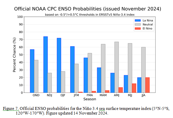
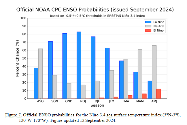
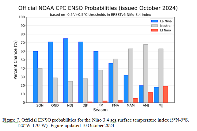
Weather Outlook for the U.S. for Today Through at Least 22 Days and a Six-Day Forecast for the World: posted November 18, 2024
This article focuses on what we are paying attention to in the next 48 to 72 hours. The article also includes weather maps for longer-term U.S. outlooks (up to four weeks) and a six-day World weather outlook which can be very useful for travelers.
First the NWS Short Range Forecast. The afternoon NWS text update can be found here after about 4 p.m. New York time but it is unlikely to have changed very much from the morning update. The images in this article automatically update.
Short Range Forecast Discussion
NWS Weather Prediction Center College Park MD
Mon Nov 18 2024
Valid 12Z Mon Nov 18 2024 – 12Z Wed Nov 20 2024…A potent storm system over the central U.S. today will create chances
for heavy rainfall, severe thunderstorms, and gusty winds, while moderate
snowfall is possible across the northern Plains by Tuesday……Heavy rain and flash flooding potential exists throughout the central
and eastern Gulf Coast over the next few days……Powerful Pacific low pressure system to impact the Northwest with high
winds and heavy mountain snow, while an atmospheric river takes aim at
northern California by Wednesday…An amplified weather pattern and two separate strong storm systems are set
to impact the Nation during the first half of this week. First, a deep low
pressure system ejecting out of West Texas early this morning is
anticipated to further organize over the central U.S. today and produce
areas of heavy rain, severe weather, and gusty winds to the
southern/central Plains. Thunderstorms forming along an attached cold
front may contain damaging winds and perhaps a few tornadoes between
central Oklahoma and North Texas today. This region is where the Storm
Prediction Center has hoisted a Slight Risk (level 2/5) of severe
thunderstorms. As the system progresses northward into the Upper Midwest
on Tuesday, showers are also forecast to spread north throughout parts of
the Midwest and Great Lakes. Meanwhile, cold air working into the western
side of the storm will likely allow for precipitation to fall as snow
across parts of North Dakota and northern Minnesota into Wednesday.
Snowfall may also be accompanied by gusty winds, leading to lower
visibility on roadways. Current snowfall probabilities for at least 4
inches of snow are greatest (70-90%) across north-central North Dakota.As the associated cold front pushes eastward through Tuesday, numerous
showers and thunderstorms interacting with a surge of moisture being
lifted northward from the Gulf of Mexico could contain intense rainfall
rates capable of producing flash flooding. Heavy rainfall is most likely
tonight across eastern Louisiana and southern Mississippi, with the threat
expanding east to the Florida Panhandle on Tuesday. Scattered flash floods
are most likely throughout low-lying and urban regions. Residents and
visitors are reminded to have multiple ways to receive warnings and never
drive across flooded roadways.For much of the Northwest, northern Great Basin, and northern Rockies, a
cold front pushing across the region today and enhanced onshore flow will
allow for unsettled weather to continue ahead of a powerful storm system
forecast to develop off the coast of the Northwest on Tuesday. This
appetizer of precipitation to start the workweek will mainly include the
potential for moderate to heavy snowfall across the Cascades and northern
Rockies. However, by Tuesday night the rapidly strengthening Pacific low
pressure system will aid in producing high winds across the Pacific
Northwest and increasing precipitation intensity. Wind gusts up to 70 mph
are possible across parts of northern California and Oregon, with strong
winds also expected over parts of western Washington. These winds will
have the potential to knock down trees and produce power outages. Heavy
snowfall with amounts potentially exceeding two feet are possible over the
northern California ranges and Cascades. By Wednesday, an associated
atmospheric rive event is expected to take shape and direct continuous
Pacific moisture towards northern California and southwest Oregon.
Widespread rainfall amounts of 4 to 7 inches are expected through
Wednesday across this region, which could produce areas of river flooding
and increase the risk of mudslides. Heavy rain and the associated weather
hazards from this atmospheric river event are also expected to continue
beyond midweek.Below average temperatures are forecast to remain over much of the western
U.S. over the next few days while gradually spreading eastward into the
Great Plains. Meanwhile, high pressure over the East will continue to
create mild and dry conditions through Tuesday as rainfall chances enter
the Mid-Atlantic and Northeast on Wednesday.
To get your local forecast plus active alerts and warnings click HERE and enter your city, state or zip code.


![[Image of rainfall potential]](https://www.nhc.noaa.gov/storm_graphics/AT19/refresh/AL1924INTQPF+gif/053133INTQPF_sm.gif)