The North American Monsoon (NAM) – Posted on April 27, 2024

In this article, I am presenting information from the National Weather Service and some other parts of NOAA on the North American Monsoon (NAM) which really is the Sonoran Monsoon but we wanted to have our own so we appropriated it. When the Sonoran Monsoon leaks into the U.S. it is called the NAM. The quoted material is indented and my comments are in boxes.

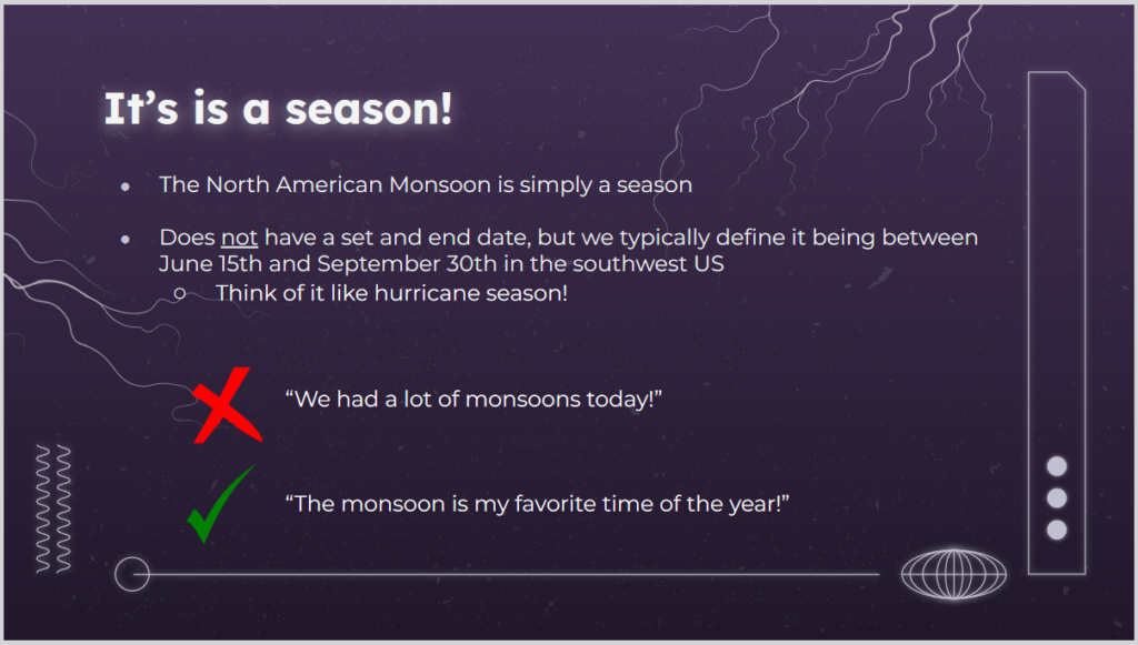
Yes and no.  Yes, it is a season not a single storm. Tucson NWS is Monsoon Headquarters and they had criteria for determining when the Monsoon started and stopped but it was felt that these were too complicated for Americans so they changed to a calendar start and stop time which works well.

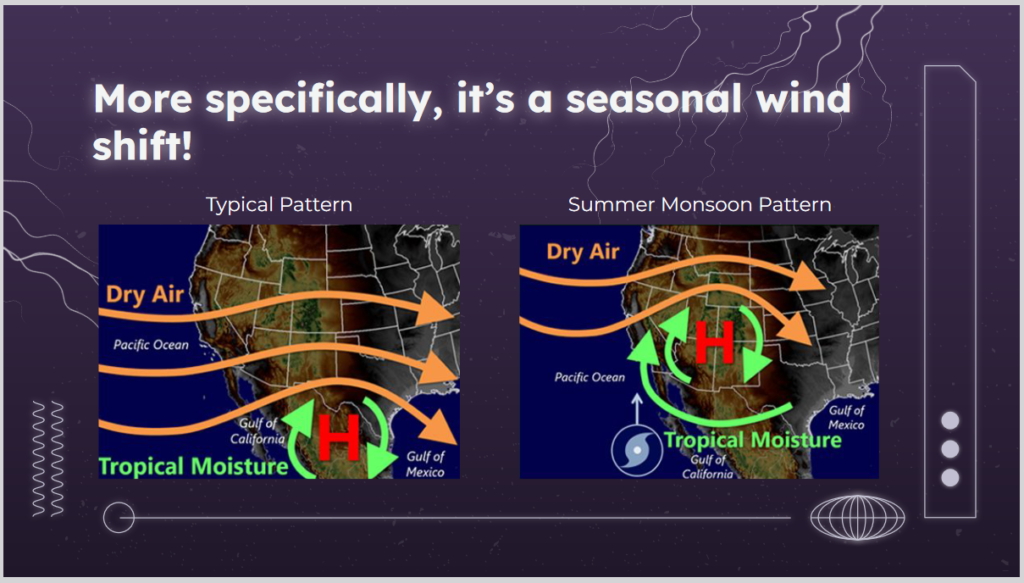
The starting point for understanding the NAM or pretty much anything in Meteorology is to think about the time of the year. In the winter, the prevailing westerlies and the jet stream dominate weather in the CONUS. In the summer they still have an impact but other mechanisms can come into play.  No time in this article to explain it but the ITCZ moves to the north.

I would like to add that the differential heading of land and water in Mexico causes moist air to rise creating thermal low which kind of shoves the high north of it to the north. The mountains also play a role in sometimes blocking air flows and uplifting air masses which causes precipitation. It is quite complex but we are going to simplify it a bit in this article.

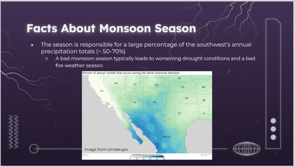
This map shows the percentage of annual precipitation that arrives during the Monsoon Season.  You can see that the NAM is very important to  Arizona, New Mexico, Kansas,  Western Texas, and the small part of Southeast California. But it is important to many other states as well. It may not provide a disproportionate part of their annual precipitation but a good monsoon versus a poor monsoon has an impact on many states.  As you can see, it is even more important to Mexico.

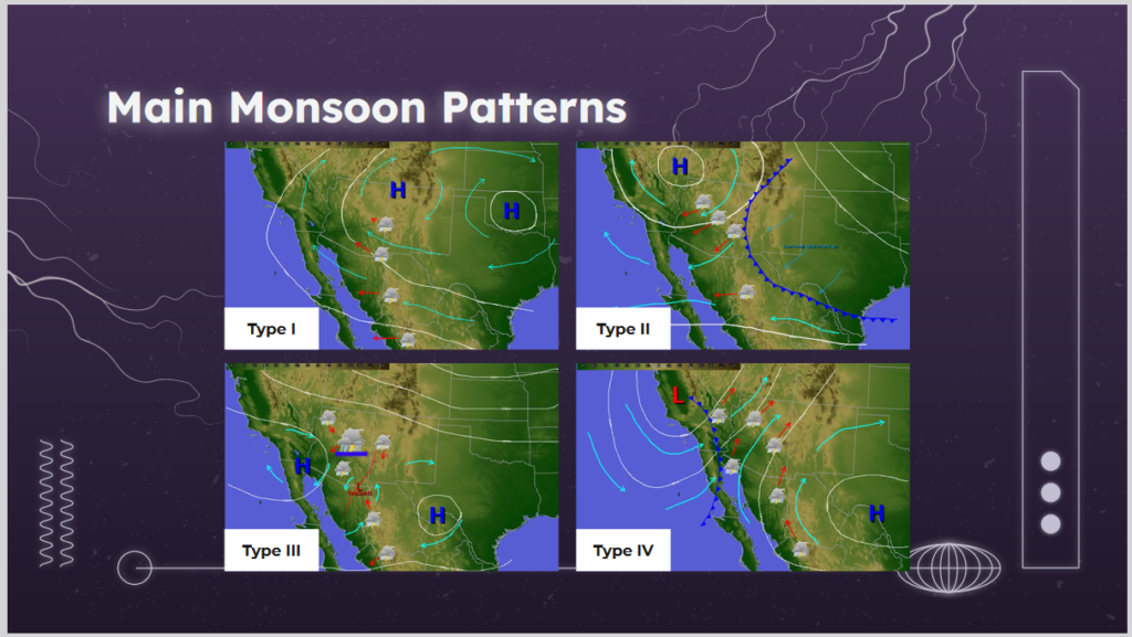
There are more than four types but these are the main ones.  We will go into detail on each of them in the body of this article. But it is really simple when you think about a high being clockwise and a low being counterclockwise.  Where you have a low west of a high, the air will be shuttled to the north from Mexico. So first look for the position of the main high-pressure area. Then look for where the low is. You will be able to figure out which way the wind will be blowing. If it is coming from where moisture is, it is likely to rain.

Some readers will need to click on “Read More” to get to the body of the article.

NOAA Updates it’s Four-Season Outlook on April 20, 2023 – The Southwest Monsoon is expected to be less productive than usual. An El Nino Winter is Expected

On the third Thursday of the month right on schedule NOAA issued what I describe as their Four-Season Outlook. The information released also included the Mid-Month Outlook for the single month of May plus the weather and drought outlook for the next three months.  I present the information issued and try to add context to it. It is quite a challenge for NOAA to address the subsequent month, the subsequent three-month period as well as successive three-month periods for a year or a bit more.

It is very useful to read the excellent discussion that NOAA issues with this Seasonal Outlook. It is best to read the full discussion but here are some of the highlights:

  • ENSO-neutral conditions are expected to continue through the Northern Hemisphere spring, followed by a 62% chance of El Niño developing during May-July 2023. An El Niño Watch has been issued, and the range of possibilities toward the end of the year includes a strong El Niño (4 in 10 chance of Niño-3.4 ≥ 1.5°C) to no El Niño (1 in 10 chance)
  • The combination of elevated snowpack and high soil moisture across much of the West coupled with below normal SSTs currently observed in the Gulf of California and the Pacific off the west Coast of the Baja California Peninsula would favor a slower evolution of monsoonal circulation.
  • El Niño is expected to become more of a factor and the pattern begins to increasingly reflect El Niño conditions during the cold months. As a result, enhanced probabilities of above normal temperatures indicated for the Southern CONUS late summer/early fall are reduced by the winter. Conversely, chances of above normal temperatures increase across the Northern Tier by the winter months.
  • As we enter the fall and winter months, the pattern begins to increasingly reflect an El Niño signature. Increased probabilities for above normal precipitation depicted across the Ohio and Mississippi Valleys during late summer and early fall transitions to the East and Gulf Coasts during the winter months, consistent with El Niño. Conversely, an increasingly dry signal is evident across the northwestern CONUS by the winter with probabilities of below normal precipitation exceeding 40 percent across the Pacific Northwest from November-December-January (NDJ) 2023-24 through JFM 2024. A tilt toward below normal precipitation is also indicated for the Great Lakes Region westward toward the Northern Plains during the cold months, consistent with El Niño.

NOAA Updates the Status of ENSO February 10, 2022

On the second Thursday of every month, NOAA issues its analysis of the status of ENSO. This includes determining the Alert System Status. Although the current status remains the same i.e.  La Nina Advisory, the forecast has been adjusted somewhat from last month. The forecast calls for the La Nina to continue to fade.  The timing is shown in the NOAA discussion and the IRI probability analysis. The Australian Meteorological Service thinks this will happen sooner and I agree. I present some information that suggests that NOAA has the timing wrong and that the transition to ENSO Neutral will occur fairly soon.

The impact of the NOAA forecast for the transition from La Nina to ENSO Neutral will show up next Thursday when NOAA issues its Seasonal Outlook. The NOAA ENSO Status Update provides an advance indication of how the forecast might change. To repeat, I expect the demise of La Nina to occur somewhat sooner than predicted by NOAA.  It is not a significant difference. There is a lag between the ENSO state and the impact on U.S. weather.  Thus the exact date when a fading La Nina meets the criteria for ENSO Neutral may not be very important in terms of the actual impact on Spring and Summer weather including the North American Monsoon (NAM). We will learn what NOAA thinks next Thursday.