Today Through the Fourth Friday (22 to 28 days) Weather Outlook for the U.S. and a Six-Day Forecast for the World: posted March 30, 2024

It is difficult to find a more comprehensive Weather Outlook anywhere else with the ability to get a local 10-day Forecast also.

This article focuses on what we are paying attention to in the next 48 to 72 hours. The article also includes weather maps for longer-term U.S. outlooks and a six-day World weather outlook which can be very useful for travelers.

First the NWS Short Range Forecast. The afternoon NWS text update can be found here but it is unlikely to have changed very much. The images in this article automatically update.

Short Range Forecast Discussion
NWS Weather Prediction Center College Park MD
Sat Mar 30 2024
Valid 12Z Sat Mar 30 2024 – 12Z Mon Apr 01 2024

…Heavy snow over parts of the Sierra Nevada Mountains and the higher
elevations of Wyoming, Nevada, Colorado, Utah, and Arizona…

…Snow over parts of the Upper Great Lakes…

…There is a Sight Risk of excessive rainfall over parts of Southern
California on Saturday…

An upper-level low will develop off the Central California Coast on
Saturday, moving inland to the Southwest by Monday. The circulation around
the low will stream moisture inland over parts of Southern California and
other parts of the West. Rain and higher-elevation snow will spread over
parts of California. The flow of moisture will create heavy rain over
parts of Southern California. Therefore, the WPC has issued a Slight Risk
(level 2/4) of excessive rainfall over parts of Southern California
through Sunday morning. The associated heavy rain will create mainly
localized areas of flash flooding, with urban areas, roads, small streams,
and burn scars the most vulnerable.

In addition, the moisture will aid in creating heavy snow over the Sierra
Nevada Mountains and the higher elevations of Wyoming, Nevada, Colorado,
Utah, and Arizona through Monday.

On Sunday, the threat of excessive rainfall decreases slightly to a
Moderate Risk over parts of Southern California and Arizona through Monday
morning. The associated heavy rain will create localized areas of flash
flooding, affecting areas that experience rapid runoff and burn scars.
Further, rain will continue over parts of Southeastern California and
Arizona through Monday.

Furthermore, low pressure over parts of the Middle Mississippi and Ohio
Valleys will move eastward off the northern Mid-Atlantic Coast by Sunday
morning. The energy will produce snow over the Upper Great Lakes through
Sunday morning. Additionally, showers and thunderstorms will develop over
the Middle Mississippi and Ohio Valleys through Monday. The SPC has issued
a Marginal Risk (level 1/5) of severe thunderstorms over parts of the
Middle Mississippi and Ohio Valleys through Monday morning. The hazards
associated with these thunderstorms are frequent lightning, strong to
severe thunderstorm wind gusts, hail, and a few tornadoes.

Elsewhere, low pressure over Eastern Canada will slowly move northeastward
farther into Canada by Saturday evening. Light snow will linger over parts
of Northern Maine through Saturday afternoon.

To get your local forecast plus active alerts and warnings click HERE and enter your city, state or zip code.

Above is a 72 hour animation of the forecast. Learn about wave patterns HERE.

Then, looking at the world and of course, the U.S. shows here also. Today we are looking at precipitation.

Please click on “Read More” below to access the full Daily Report issued today.

29 Mar 2023 Market Close & Major Financial Headlines: NYSE Closed For Good Friday

Summary Of the Markets Today:

  • Gold $2,255 up $42.10,
  • WTI crude oil settled at $83 up $1.76,
  • 10-year U.S. Treasury 4.206% up 0.010 points,
  • USD index $104.52 down $0.030,
  • Bitcoin $69,676 up $1,135 (1.61%)

*Stock data, cryptocurrency, and commodity prices at the market closing.


Click here to read our current Economic Forecast – March 2024 Economic Forecast: A Modest Improvement In Our Index Predicting Little Change In Main Street Growth


Today’s Economic Releases Compiled by Steven Hansen, Publisher:

The number of CEO changes at U.S. companies surged to 248 in February, up 28% from the 194 CEO exits recorded in January. It is a 49% increase from the 167 CEO exits that occurred in the same month one year prior. February’s total is the highest monthly total on record. The previous record was set in January 2020, when 219 CEOs left their posts. Andrew Challenger, Senior Vice President of Challenger, Gray & Christmas, Inc. stated:

This suggests CEOs who took the position temporarily in 2019 extended their tenures due to the pandemic, and are deciding to leave their posts now.

CEO Exits by month from January 2020 - February 2024 by Challenger, Gray & Christmas Inc.

Disposable personal income (DPI), personal income less personal current taxes, increased 1.7% year-over-year in February 2024- down from 2.1% in January. Personal consumption expenditures (PCE) increased 2.4% year-over-year – up from 2.o% in January. The PCE price index was little changed at 2.5% year-over-year –  excluding food and energy, the PCE price index also was little changed at 2.8%. The bottom line is that inflation is no longer subsiding.


Here is a summary of headlines we are reading today:

  • Chinese Solar Companies Skimp on Quality As Price War Escalates
  • South Sudan’s Oil Revenues Plunge as Ruptured Pipeline Stalls Exports
  • U.S. Drilling Activity Slips Again
  • Fisker Slashes Prices of Its Ocean SUV by 39%
  • Indonesia to Quadruple Battery-Grade Nickel Output by 2030
  • Key Fed inflation gauge rose 2.8% annually in February, as expected
  • Tesla’s awful quarter has Wall Street on edge ahead of delivery numbers
  • Russia launches barrage of 99 drones and missiles on Ukraine’s energy system, officials say
  • Investors are focused ‘overwhelmingly’ on bitcoin over other cryptocurrencies, BlackRock says
  • The Meltdown Of Commercial Real Estate
  • Tupperware sounds another warning for investors with more filing delays

Click on the “Read More” below to access these, other headlines, and the associated news summaries moving the markets today.

Today Through the Fourth Friday (22 to 28 days) Weather Outlook for the U.S. and a Six-Day Forecast for the World: posted March 29, 2024

It is difficult to find a more comprehensive Weather Outlook anywhere else with the ability to get a local 10-day Forecast also.

This article focuses on what we are paying attention to in the next 48 to 72 hours. The article also includes weather maps for longer-term U.S. outlooks and a six-day World weather outlook which can be very useful for travelers.

First the NWS Short Range Forecast. The afternoon NWS text update can be found here but it is unlikely to have changed very much. The images in this article automatically update.

Short Range Forecast Discussion
NWS Weather Prediction Center College Park MD
Fri Mar 29 2024
Valid 12Z Fri Mar 29 2024 – 12Z Sun Mar 31 2024

…Heavy snow over parts of the Sierra Nevada Mountains and the higher
elevations of Wyoming, Colorado, Utah, and Northern Maine…

…Light to moderate snow over parts of the Upper Midwest…

…There is a Sight Risk of excessive rainfall over parts of Southern
California on Friday and Saturday and Northern Maine on Friday…

An upper-level low will develop off the Northwest Coast and move southward
to off Southern California by Sunday. The circulation around the low will
stream moisture inland over parts of Southern California and other parts
of the West. Coastal rain will develop over parts of the Pacific
Northwest, and rain/higher-elevation snow will spread over parts of
California. By Friday afternoon, the flow of moisture will create heavy
rain over parts of Southern California. Therefore, the WPC has issued a
Slight Risk (level 2/4) of excessive rainfall over parts of Southern
California through Saturday morning. The associated heavy rain will create
mainly localized areas of flash flooding, with urban areas, roads, small
streams, and burn scars the most vulnerable.

In addition, the moisture will aid in creating heavy snow over the Sierra
Nevada Mountains and the higher elevations of Wyoming, Colorado, and Utah
through Sunday. Moreover, the heavy rain will continue over Southern
California on Saturday. Therefore, the WPC has issued a Slight Risk (level
2/4) of excessive rainfall over parts of Southern California on Saturday
through Sunday morning. The associated heavy rain will create mainly
localized areas of flash flooding, with urban areas, roads, small streams,
and burn scars the most vulnerable.

Furthermore, upper-level energy over the Northern Tier States will move
eastward across the Great Lakes into the Northeast by Sunday. The energy
will produce light to moderate snow over the Northern Tier States into the
Great Lakes through Sunday. Additionally, showers and thunderstorms will
develop over the Upper/Middle Mississippi Valley and Great Lakes/Ohio
Valley by Friday evening into Sunday. Along the rain/snow line, a few
pockets of light rain/freezing rain will develop over parts of the Upper
Mississippi Valley and Upper Great Lakes late Friday night into Saturday.

Meanwhile, low pressure off the Northeast Coast will move northward into
Eastern Canada by Saturday evening. Moisture will stream along the
Northeast Coast, creating heavy rain along the Maine Coast. Therefore, the
WPC has issued a Slight Risk (level 2/4) of excessive rainfall over parts
of the Maine Coast through Saturday morning. The associated heavy rain
will create mainly localized areas of flash flooding, with urban areas,
roads, and small streams the most vulnerable.

Further, the energy associated with the low will help produce heavy snow
over parts of Northern Maine through Saturday morning. Snow will linger
over Northern Maine through Sunday.

To get your local forecast plus active alerts and warnings click HERE and enter your city, state or zip code.

Above is a 72 hour animation of the forecast. Learn about wave patterns HERE.

Then, looking at the world and of course, the U.S. shows here also. Today we are looking at precipitation.

Please click on “Read More” below to access the full Daily Report issued today.

28 Mar 2023 Market Close & Major Financial Headlines: Markets Opened Fractionally Mixed, Traded Sideways Across The Unchanged Line, S&P 500 Marks New Historic High, Major Indexes Closed Mixed

Summary Of the Markets Today:

  • The Dow closed up 47 points or 0.12%,
  • Nasdaq closed down 0.12%,
  • S&P 500 closed up 0.11%, ( New high 5,265)
  • Gold $2,241 up $28.30,
  • WTI crude oil settled at $83 up $1.62,
  • 10-year U.S. Treasury 4.206% up 0.010 points,
  • USD index $104.54 up $0.190,
  • Bitcoin $70,903 up $2,265 (3.27%), – Historic high 73,798.25
  • Baker Hughes Rig Count: U.S. -3 to 621 Canada -18 to 151

*Stock data, cryptocurrency, and commodity prices at the market closing.


Click here to read our current Economic Forecast – March 2024 Economic Forecast: A Modest Improvement In Our Index Predicting Little Change In Main Street Growth


Today’s Economic Releases Compiled by Steven Hansen, Publisher:

The third estimate of 4Q2023 Real gross domestic product (GDP) increased 3.1% year-over-year – up from the third quarter real GDP of 2.9% year-over-year. The GDP implicit price deflator (inflation seen withing GDP) improved from 3.2% to 2.6% year-over-year.

In the week ending March 23, the advance figure for seasonally adjusted initial unemployment claims 4-week moving average was 211,000, a decrease of 750 from the previous week’s revised average. The previous week’s average was revised up by 500 from 211,250 to 211,750.

The Chicago Business Barometer declined 2.6 points to 41.4 in March.  This is the fourth consecutive monthly decrease, pushing the index further into contractionary territory, and marking the lowest print since May 2023.  We also note that this print is 4 points below the 2023 average. The Chicago PMI is used by pundits as an early indicator of the national PMI. There is little question that manufacturing is in a recession in the U.S.

The Pending Home Sales Index (PHSI)* – a forward-looking indicator of home sales based on contract signings – increased to 75.6 in February. Year over year, pending transactions were down 7.0%. An index of 100 is equal to the level of contract activity in 2001. NAR Chief Economist Lawrence Yun stated:

While modest sales growth might not stir excitement, it shows slow and steady progress from the lows of late last year. Ongoing job gains are clearly increasing demand along with more inventory.

Here is a summary of headlines we are reading today:

  • Gold Recycling Goes Green with Biodiesel Innovation
  • Citigroup Says 42% of Clients Have No Energy Transition Plan
  • Russian Warships Enter The Red Sea amid Houthi Attacks
  • Over 20% of the World’s Oil Refining Capacity Is at Risk of Closure
  • FTX founder Sam Bankman-Fried sentenced to 25 years for crypto fraud, to pay $11 billion in forfeiture
  • S&P 500 closes at a fresh record, posts strongest first quarter performance since 2019: Live updates
  • The wealth of the 1% just hit a record $44 trillion
  • Appeals Court Extends Block On Texas Arrests Of Illegal Immigrants
  • The S&P 500 and Wall Street’s ‘fear gauge’ are both up in 2024. Should investors be worried?
  • Oil ends higher, with U.S. prices up 16% for the quarter

Click on the “Read More” below to access these, other headlines, and the associated news summaries moving the markets today.

Today Through the Fourth Friday (22 to 28 days) Weather Outlook for the U.S. and a Six-Day Forecast for the World: posted March 28, 2024

It is difficult to find a more comprehensive Weather Outlook anywhere else with the ability to get a local 10-day Forecast also.

This article focuses on what we are paying attention to in the next 48 to 72 hours. The article also includes weather maps for longer-term U.S. outlooks and a six-day World weather outlook which can be very useful for travelers.

First the NWS Short Range Forecast. The afternoon NWS text update can be found here but it is unlikely to have changed very much. The images in this article automatically update.

Short Range Forecast Discussion
NWS Weather Prediction Center College Park MD
Thu Mar 28 2024
Valid 12Z Thu Mar 28 2024 – 12Z Sat Mar 30 2024

…Rainy, stormy weather continues along the East Coast through today,
lingering in New England Friday…

…Unsettled weather for the West, with a late season Atmospheric River
impacting California Friday…

…Warming trend begins over Central U.S. today…

Two slow moving frontal boundaries will continue to push towards the East
Coast today, with the leading front pushing into the Atlantic by early
afternoon and the second front slowing approaching the coast while
weakening through this evening. Chances for showers and thunderstorms will
continue through today along the East Coast but taper off from south to
north as the leading front exits. Locally heavy rainfall will be possible
over portions of the eastern Mid-Atlantic and coastal New England, which
may cause isolated to scattered instances of flash flooding. The highest
risk for flash flooding will be over eastern North Carolina and far
southeastern Virginia as a wave of low pressure moves along the frontal
boundary today, and there is a Slight Risk of Excessive Rainfall (level
2/4) for this area. Precipitation chances will likely linger through
Friday for portions of New England as low pressure strengthens just east
of the region. Colder air moving in from the north will allow rain to
switch to wintry mixed precipitation and snow overnight into Friday for
inland areas. Winds will also become gusty in the Northeast on Friday and
Saturday as the low strengthens and the pressure gradient tightens.

Meanwhile, a frontal system will push southeast across much of the West
with unsettled weather today into Friday. Mountain snow and low elevation
rain will impact the region, and locally heavy snow will be possible for
regional mountain ranges from the Pacific Northwest southward into
northern/central California, as well as for the eastern Great Basin into
the northern/central Rockies. Low pressure associated with the
southeastward moving frontal system will push into the northern and
central Plains on Friday and reach the Great Lakes region by Saturday
morning. This will bring chances for wintry precipitation to the Upper
Midwest and northern Great Lakes and chances for showers and thunderstorms
to portions of the Midwest and Ohio Valley.

On Friday afternoon, a Pacific low pressure system will approach the
California coast. This system will aim a plume of moisture (an atmospheric
river) at central and southern California Friday night into Saturday,
which will result in heavy rainfall and potentially flash flooding. There
is a Slight Risk of Excessive Rainfall (level 2/4) for portions of coastal
southern California on Friday and Saturday where upslope flow along
terrain will likely enhance rainfall totals and could lead to scattered
instances flooding.

Temperature-wise, lows this morning will be chilly, dropping into the low
to mid-30s across portions of the Mid-South into the Tennessee Valley
following a cold front passage, and Frost/Freeze-related advisories and
warnings are in place for newly greening sensitive vegetation. Increasing
upper-level ridging over will bring warmer, above average temperatures to
portions of the Central U.S. today, to the Plains, Mississippi Valley, and
Midwest on Friday, and to the Southeast and Mid-Atlantic on Saturday.
Below average high temperatures are forecast for much of the West through
the weekend due to expected cloud cover and precipitation and for the
northern high Plains Friday through the weekend as colder air moves in
behind a cold front.

To get your local forecast plus active alerts and warnings click HERE and enter your city, state or zip code.

Above is a 72 hour animation of the forecast. Learn about wave patterns HERE.

Then, looking at the world and of course, the U.S. shows here also. Today we are looking at precipitation.

Please click on “Read More” below to access the full Daily Report issued today.

27 Mar 2023 Market Close & Major Financial Headlines: Markets Opened Sharply Higher, Fell to Moderate Levels And Traded Sideways Until The Last hour Where The Three Major Indexes Skyrocket Higher Exceeding Opening Levels

Summary Of the Markets Today:

  • The Dow closed up 478 points or 1.22%,
  • Nasdaq closed up 0.51%,
  • S&P 500 closed up 0.86%,
  • Gold $2,212 up $13.20,
  • WTI crude oil settled at $82 up $0.07,
  • 10-year U.S. Treasury 4.190% down 0.044 points,
  • USD index $104.30 up $0.010,
  • Bitcoin $68,641 down $1,000 (0.10%),

*Stock data, cryptocurrency, and commodity prices at the market closing.


Click here to read our current Economic Forecast – March 2024 Economic Forecast: A Modest Improvement In Our Index Predicting Little Change In Main Street Growth


Today’s Economic Releases Compiled by Steven Hansen, Publisher:

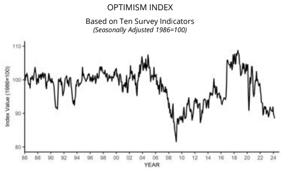
When asked between February 20 and March 8 to rate optimism about the overall U.S. economy on a scale from 0 to 100, the average rating from CFOs was 60.6, up from 58.1 in the fourth quarter. Optimism about their own firm’s prospects remained higher than economic optimism, at an average of 68.5, up from 67.5 in the fourth quarter.

Here is a summary of headlines we are reading today:

  • Western Wind Turbine Manufacturers Struggle to Compete with Chinese Pricing
  • Investigators To Examine Whether Dirty Fuel Caused Baltimore Bridge Crash
  • Nickel Prices Expected to Drop Further in 2024
  • Nissan Unveils New Strategy to Combat Influx of Competitive Chinese EVs
  • Baltimore Coal Exports Blocked After Bridge Collapse
  • Pump Prices Set to Hit $4 a Gallon
  • Dow surges more than 450 points, S&P 500 closes at a fresh record: Live updates
  • Amazon spends $2.75 billion on AI startup Anthropic in its largest venture investment yet
  • Ron Insana’s new firm aims to bring AI-powered trade ideas to individual investors
  • AMC’s stock on pace for biggest gain in a month

Click on the “Read More” below to access these, other headlines, and the associated news summaries moving the markets today.

Today Through the Fourth Friday (22 to 28 days) Weather Outlook for the U.S. and a Six-Day Forecast for the World: posted March 27, 2024

It is difficult to find a more comprehensive Weather Outlook anywhere else with the ability to get a local 10-day Forecast also.

This article focuses on what we are paying attention to in the next 48 to 72 hours. The article also includes weather maps for longer-term U.S. outlooks and a six-day World weather outlook which can be very useful for travelers.

First the NWS Short Range Forecast. The afternoon NWS text update can be found here but it is unlikely to have changed very much. The images in this article automatically update.

Short Range Forecast Discussion
NWS Weather Prediction Center College Park MD
Wed Mar 27 2024
Valid 12Z Wed Mar 27 2024 – 12Z Fri Mar 29 2024

…Rainy, stormy weather across the Southeast Coast through Thursday…

…Unsettled weather arrives over Northwest today…

…Warming trend begins over Central U.S. on Thursday…

A stalled out surface front along the Southeast Coast will be the focus
for heavy rain and thunderstorms through Thursday afternoon. There are
Slight Risks (at least 15%) of Excessive Rainfall leading to Flash
Flooding over parts of eastern North Carolina and southeast
Georgia/northern Florida today, where areas of surface low pressure along
the stationary front may enhance rainfall rates/totals. The Storm
Prediction Center has only a Marginal Risk (level 1/5) of Severe
Thunderstorms along the Southeast Coast today. Rain showers should develop
along the Mid-Atlantic and Northeast Coasts today along and ahead of a
northern stream cold front. There’s a Slight Risk of Excessive Rainfall
for portions of southeastern Virginia into northeastern North Carolina on
Thursday morning, right before the low pressure system and associated
precipitation push off into the Atlantic. Showers continue along the
Northeast Coast on Thursday with some potential snow showers developing
over interior portions of New England. Coastal low development along the
New England coast could also support some enhanced rain totals for
southern New England, in particular, by Friday morning.

Out West, a period of rainy/snowy weather will ensue across the Northwest
today. Precipitation will spread across the Pacific Northwest this morning
then into northern California and the interior Northwest this
afternoon/evening. Moderate to heavy snow is possible over parts of the
Cascades, Sierra Nevada and Northern Rockies; where between 1-2 feet of
snow may accumulate by Friday morning. Elsewhere, troughing along the lee
of the Rockies will promote southerly flow into the Great Plains beginning
Thursday. This pattern will support above average temperatures from the
Central/Southern Plains into the Midwest through the weekend.

To get your local forecast plus active alerts and warnings click HERE and enter your city, state or zip code.

Above is a 72 hour animation of the forecast. Learn about wave patterns HERE.

Then, looking at the world and of course, the U.S. shows here also. Today we are looking at precipitation.

Please click on “Read More” below to access the full Daily Report issued today.

Vicki Barbera: A sexy ballroom dancer

Vicki Barbera: A sexy ballroom dancer

Vicki stumbled into the world of ballroom dancing purely by accident at the age of 52. Like probably every amateur student ever, she went to a ballroom party and then thought she would just try a few lessons. Before she could hardly catch her breath, she was hooked, taking multiple lessons weekly, and then even competing, known as a “sexy dancer” …

26 Mar 2023 Market Close & Major Financial Headlines: Markets Opened Fractionally Higher, Traded Mostly Sideways In The Green, Then Like A Waterfall, The Markets Fell Sharply During The Last Hour Of Today’s Session

Summary Of the Markets Today:

  • The Dow closed down 31 points or 0.08%,
  • Nasdaq closed down 0.42%,
  • S&P 500 closed down 0.28%,
  • Gold $2,200 up $1.70,
  • WTI crude oil settled at $82 down $0.43,
  • 10-year U.S. Treasury 4.232% down 0.021 points,
  • USD index $104.33 down $0.150,
  • Bitcoin $69,889 down $966 (1.33%), – Historic high 73,798.25

Click here to read our current Economic Forecast – March 2024 Economic Forecast: A Modest Improvement In Our Index Predicting Little Change In Main Street Growth


Today’s Economic Releases Compiled by Steven Hansen, Publisher:

New orders for manufactured durable goods in February 2024 improved and is up 2.6% year-over-year – but is down 1.6% year-over-year inflation-adjusted. Negative growth in durable goods is not a sign of a growing economy.

The S&P CoreLogic Case-Shiller U.S. National Home Price NSA Index 20-City Composite posted a year-over-year increase of 6.6% in January 2024, up from a 6.2% increase in the previous month. Brian D. Luke, Head of Commodities, Real & Digital Assets at S&P Dow Jones Indices stated:

We’ve commented on how consistent each market performed during 2023 and that continues to be the case. While there is a large disparity between leaders such as San Diego versus laggards such as with Portland, the broad market performance is tightly bunched up. This is also true of high and low tiers. The average annual gains between high and low tiers across cities tracked by the indices is just 1.1%. Low price tiered indices have outperformed high priced indices for 17 months. Homeowners most likely saw healthy gains in the last year, no matter what city you were in, or if it was in an expensive or inexpensive neighborhood. No matter which way you slice it, the index performance closely resembled the broad market.

The Richmond Fed manufacturing activity slowed in March 2024. The composite manufacturing index decreased from −5 in February to −11. Of its three component indexes, shipments remained solidly negative at −14, new orders fell from −5 to −17, and employment fell from 7 to 0. Manufacturing remains in a recession in the U.S.

The Conference Board Consumer Confidence Index® was 104.7 (1985=100) in March, essentially unchanged from a downwardly revised 104.8 in February. Dana M. Peterson, Chief Economist at The Conference Board added:

Consumers’ assessment of the present situation improved in March, but they also became more pessimistic about the future. Confidence rose among consumers aged 55 and over but deteriorated for those under 55. Separately, consumers in the $50,000-$99,999 income group reported lower confidence in March, while confidence improved slightly in all other income groups. However, over the last six months, confidence has been moving sideways with no real trend to the upside or downside either by income or age group.


Here is a summary of headlines we are reading today:

  • South Africa Won’t Ditch Coal Anytime Soon
  • OPEC: Oil Industry Needs $11 Trillion in Upstream Investment by 2045
  • Subsidy Investigation Sent China’s EV Exports to the EU Plunging by 20%
  • Bullish Sentiment Brings $90 Oil Within Reach
  • Logistics companies scramble after bridge collapse closes Port of Baltimore until further notice
  • S&P 500 closes lower for a third straight session as market rally cools: Live updates
  • Stocks trade near records, but chances are your portfolio isn’t sufficiently protected from a fall
  • Bitcoin maintains $70,000, and KuCoin charged with anti-money laundering violations: CNBC Crypto World
  • Tesla Cooperates With CATL On Faster-Charging Battery Technology
  • Donald Trump media firm soars in stock market debut
  • Treasury yields hold steady as traders eye February inflation data at end of week

Click on the “Read More” below to access these, other headlines, and the associated news summaries moving the markets today.

Today Through the Fourth Friday (22 to 28 days) Weather Outlook for the U.S. and a Six-Day Forecast for the World: posted March 26, 2024

It is difficult to find a more comprehensive Weather Outlook anywhere else with the ability to get a local 10-day Forecast also.

This article focuses on what we are paying attention to in the next 48 to 72 hours. The article also includes weather maps for longer-term U.S. outlooks and a six-day World weather outlook which can be very useful for travelers.

First the NWS Short Range Forecast. The afternoon NWS text update can be found here but it is unlikely to have changed very much. The images in this article automatically update.

Short Range Forecast Discussion
NWS Weather Prediction Center College Park MD
Tue Mar 26 2024
Valid 12Z Tue Mar 26 2024 – 12Z Thu Mar 28 2024

…Winter Storm comes to an end over the Northern/Central Plains and Upper
Midwest; well below average temperatures over Great Plains…

…Severe Weather potential over parts of the Midwest and central Gulf
Coast today…

…Heavy to Excessive Rainfall possible over portions of the Southeast and
Mid-Atlantic…

…Unsettled weather returns to the Northwest on Wednesday…

Heavy snow and blizzard conditions associated with a deep mid-latitude
cyclone impacting the Northern/Central Plains and Upper Midwest will come
to an end today. Additional snowfall accumulations of 2-4 inches are
expected across eastern Minnesota by Wednesday morning, when the system is
forecast to move into Ontario/southern Canada. A frigid airmass will
continue to spread across the Great Plains today and Wednesday behind a
cold front. Highs will be 15-25 degrees below average for much of the
Plains today. Temperatures will moderate later this week.

Rain showers and scattered to isolated thunderstorm activity are likely
east of the Mississippi River today. Storms will organize along a pair of
cold fronts associated with two separate low pressure systems; the Upper
Midwest system and the Gulf Coast system. The Storm Prediction Center
issued a Slight Risk of Severe Thunderstorms (level 2/5) for parts of the
southern Great Lakes and for portions of the Gulf Coast today. Damaging
wind gusts will be the main threat for both areas, but a brief tornado
can’t be ruled out over the Gulf Coast. The Gulf system is forecasted to
stall out over the Southeast/Florida panhandle this afternoon/evening
leading to potentially heavy rainfall occurring particularly over the
Florida panhandle. Significant moisture return from the Gulf will interact
with the slow moving cold front, which will produce an axis of 2-4 inches
of rain from northern Florida through the Southeast coast on Wednesday. A
Slight Risk (at least 15%) of Excessive Rainfall leading to Flash Flooding
is in effect for parts of north-central Florida into southern Georgia.

A deep low pressure system will bring another round of unsettled weather
to the Northwest beginning on Wednesday. Low elevation rain and mountain
snow are expected from this system. Accumulating snow should remain
confined to the higher elevations of the Cascades, Sierra Nevada and
Northern Rockies. Some 1-2 inch 24 hour rainfall totals pose a Marginal
Risk (at least 5%) of Excessive Rainfall leading to Flash Flooding over
parts of the northern California into southern Oregon coastline.

To get your local forecast plus active alerts and warnings click HERE and enter your city, state or zip code.

Above is a 72 hour animation of the forecast. Learn about wave patterns HERE.

Then, looking at the world and of course, the U.S. shows here also. Today we are looking at precipitation.

Please click on “Read More” below to access the full Daily Report issued today.