16 DEC 2024 Market Close & Major Financial Headlines: The Dow Records Its 8th. Session Closing In The Red, While The Small Cap Flourish, Closing Fractionally Higher – Déjà vu

Summary Of the Markets Today:

  • The Dow closed down 111 points or 0.25%,
  • Nasdaq closed up 247 points or 1.24%,   (New Historic high 20,205, Closed at 20,704)
  • S&P 500 closed up 23 points or 0.38%,
  • Gold $2,671 down $5.20 or 0.19%,
  • WTI crude oil settled at $71 down $0.68 or 0.95%,
  • 10-year U.S. Treasury 4.397 down 0.002 points or 0.046%,
  • USD index $106.88 down $0.13 or 0.12%,
  • Bitcoin $106,014 up $2,958 or 2.79%, (24 Hours), (New Bitcoin Historic high 107,705)

*Stock data, cryptocurrency, and commodity prices at the market closing

Today’s Highlights

The Nasdaq Composite achieved a fresh record high on Monday, driven by strong performances from major tech stocks and the cryptocurrency market. Big Tech stocks hitting new record highs include Alphabet (GOOGL), Tesla (TSLA), Amazon (AMZN), Apple (AAPL), and Broadcom (AVGO). MicroStrategy’s stock surged ahead of its inclusion in the Nasdaq 100 whilst Super Micro Computer Inc. shares fell due to its upcoming removal from the Nasdaq 100. The Dow Jones Industrial Average declined for its eighth consecutive session of losses. Investors are anticipating the Federal Reserve’s final meeting of the year on Tuesday, with a 97% likelihood of a 25 basis point rate cut. The key focus is on the Fed’s potential outlook for rate cuts in 2025, considering persistent inflation and potential policy challenges. Bitcoin reached an all-time high above $107,000. Healthcare stocks (CVS, UnitedHealth, Cigna) declined after comments from President-elect Donald Trump about pharmacy benefit managers.


Click here to read our current Economic Forecast – December 2024 Economic Forecast: Insignificant Improvement And Still Indicating a Weak Economy


Today’s Economic Releases Compiled by Steven Hansen, Publisher:

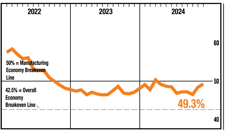
New York Fed’s Empire State Manufacturing Survey declined thirty-one points to 0.2. Last month I rode my high horse telling you this is a survey and I do not like surveys. When I was in the industry – I had my admin assistant fill out these survey forms (telling him or her not to bother me with questions – just get it done). How many people out there think that in November manufacturing was screaming good and in December things now suck. Bottom line is that I see no real end to the manufacturing recession in the USA.

Here is a summary of headlines we are reading today:

  • Copper: The Driving Force Behind the Clean Energy Revolution
  • Indonesia’s Growing Nickel Production Disrupts Global Market
  • Forget Short-Term Noise: Oil Prices Are All About the Long-Term Trend
  • What Does The Fall Of Assad’s Syria Mean To The Key Players In The Middle East?
  • Russia’s $10 Billion Shadow Armada Exposed by Ukrainian Intelligence
  • Nvidia falls into correction territory, down more than 10% from its record close
  • Dow falls for an eighth day ahead of Fed, but Nasdaq notches another record: Live updates
  • Broadcom jumps 11%, extending record run as Goldman expresses ‘higher conviction’
  • Bitcoin rises to new record above $107,000 ahead of this week’s Fed decision
  • How Will Apple Compete With $168 AI Smartphones From China?
  • Intrinsic Value Of Crypto: What Is It & How To Calculate It
  • 2-year Treasury yield ends at almost three-week high after strong services-sector data

Click on the “Read More” below to access these, other headlines, and the associated news summaries moving the markets today.

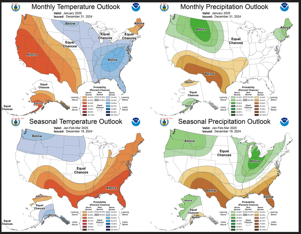
Weather Outlook for the U.S. for Today Through at Least 22 Days and a Six-Day Forecast for the World: posted December 16, 2024

This article focuses on what we are paying attention to in the next 48 to 72 hours. The article also includes weather maps for longer-term U.S. outlooks (up to four weeks) and a six-day World weather outlook which can be very useful for travelers.

First the NWS Short Range Forecast. The afternoon NWS text update can be found here after about 4 p.m. New York time but it is unlikely to have changed very much from the morning update. The images in this article automatically update.

Short Range Forecast Discussion
NWS Weather Prediction Center College Park MD
Mon Dec 16 2024
Valid 12Z Mon Dec 16 2024 – 12Z Wed Dec 18 2024

…Modest atmospheric river activity to bring unsettled weather to the
Northwest, including heavy rains for the coastal ranges and accumulating
snow for the higher elevations…

…Wet conditions expected for much of the eastern half of the country the
next couple of days…

…Above average temperatures, mild conditions expected for much of the
country to start the week…

A pair of Pacific systems will help to focus a flow of moisture over the
Northwest in an active Atmospheric River pattern the next couple of days.
Precipitation continues this morning as moisture flows inland from the
first system bringing moderate to heavy coastal rain, an inland wintry
mix, and heavy higher elevation mountain snow across the Pacific
Northwest, northern California, and the northern Great Basin/Rockies. The
heaviest precipitation will be focused southward today across
Oregon/northern California and inland through central Idaho into northwest
Wyoming. The focus will shift northward on Tuesday bringing heavier rain
to coastal Washington state as well as heavy snow to the northern
Cascades. Snow totals of 4-8″ will be common with locally higher totals
over a foot for the highest peaks expected, particularly for the southern
Cascades in Oregon Monday.

To the east, light to moderate rainfall continues this morning over the
Mid-Atlantic with some wintry precipitation over the Interior Northeast,
which should taper off through early afternoon. A more focused corridor of
showers and thunderstorms will redevelop through the day ahead of a cold
front over the Ohio Valley southwestward through the Lower Mississippi
Valley/Southern Plains. Some moderate to locally heavy rainfall will be
possible, particularly for the Ohio Valley. This system will bring another
wave of rain through the Mid-Atlantic Monday evening and New England
Tuesday morning, with a wintry mix possible for interior locations. An
approaching upper-level wave will help to kick off another round of
showers and storms along the frontal boundary from the Ohio Valley
southwest through the Southern Plains Tuesday.

Elsewhere, an upper-level wave passing over the Northern Plains/Upper
Midwest will bring some snow showers on Tuesday with some light
accumulations possible. Some lake effect snow showers are also expected to
continue downwind of the Great Lakes, particularly Lakes Erie and Ontario.
Daily shower and thunderstorm chances are forecast for the Florida
Peninsula with coverage and intensity increasing on Tuesday along the
Atlantic Coast. Much of the country will see high temperatures above
average with generally mild conditions. Some of the greatest anomalies
will be over the Midwest Monday as highs climb into the 50s, and over the
Northeast Tuesday with highs into the 50s and 60s. Frontal passages will
lead to more temperature fluctuation along the northern tier of the
country while the southern tier will remain more stable, with daily highs
generally in the 60s and 70s.

To get your local forecast plus active alerts and warnings click HERE and enter your city, state or zip code.

Learn about wave patterns HERE.

Then, looking at the world and of course, the U.S. shows here also. Today we are looking at precipitation.

Please click on “Read More” below to access the full Daily Report issued today.

Weather Outlook for the U.S. for Today Through at Least 22 Days and a Six-Day Forecast for the World: posted December 15, 2024

This article focuses on what we are paying attention to in the next 48 to 72 hours. The article also includes weather maps for longer-term U.S. outlooks (up to four weeks) and a six-day World weather outlook which can be very useful for travelers.

First the NWS Short Range Forecast. The afternoon NWS text update can be found here after about 4 p.m. New York time but it is unlikely to have changed very much from the morning update. The images in this article automatically update.

Short Range Forecast Discussion
NWS Weather Prediction Center College Park MD
Sun Dec 15 2024
Valid 12Z Sun Dec 15 2024 – 12Z Tue Dec 17 2024

…Wintry mix expected for the Appalachians Sunday with the potential for
significant icing in the central Appalachians…

…Showers and storms with locally heavy rainfall possible across the
Lower Ohio Valley through Monday…

…Pacific system to bring a renewed round of lower elevation/coastal rain
and heavy mountain snow to the Northwest late Sunday into Monday…

An upper-level wave has helped trigger a broad area of wintry
precipitation this morning which will pass through the interior
Northeast/Appalachians through the day Sunday. Some light snow
accumulations will be possible for the central/northern Appalachians with
some ice accretions expected for the southern/central Appalachians. More
significant ice accretions of 0.1-0.3″ are forecast for a smaller region
of eastern West Virginia north through western Maryland and into southwest
Pennsylvania which could cause tree and power line damage. Some lighter
rain showers will be possible along the Eastern Seaboard. The wintry
precipitation will lift northward into New England bringing some lighter
accumulations into the day Monday.

Further West, another upper-level wave/accompanying surface frontal system
will better organize along the High Plains and push eastward into the
Plains Sunday. Some light snow/ice accumulations will be possible
northwest of the system over portions of the northern Plains through
Sunday evening before shifting into the Upper Midwest Monday. To the
south, moist return flow form the Gulf reaching the eastward moving
frontal system will lead to increasing coverage of showers and
thunderstorms across the Lower Ohio Valley southwest into the Southern
Plains by late Sunday. Coverage and intensity should increase through the
day Monday as the front pushes southeastward into the Tennessee Valley and
Lower Mississippi Valley through Monday evening. Some locally heavy
rainfall will be possible, particularly across the Lower Ohio Valley
Monday. Showers are also expected to spread eastward into the Northeast
Monday.

Some moderate to locally heavy snow will continue through Sunday morning
for higher mountain elevations of the northern Rockies/Great Basin as well
as for the Cascades as an upper-level trough departs the region.
Precipitation should generally tend to taper off through the afternoon.
However, another Pacific system approaching the Pacific Northwest/northern
California will bring a renewed round of precipitation spreading inland
through the Northwest by Sunday night. Moderate to heavy lower
elevation/coastal rain, a wintry mix for inland valleys, and moderate to
heavy mountain snow can all be expected through Monday. The heaviest snow
totals of 8-12″, locally higher, are most likely from the southern
Cascades/northern California east through Oregon into central Idaho and
northwest Wyoming. Some gusty winds can also be expected along the Pacific
Coast.

Elsewhere, some showers and thunderstorms will be possible along the east
coast of Florida north through the Carolinas the next couple of days.
Temperature-wise, conditions will generally be at or above average for
most of the country. Some of the most anomalous temperatures will be over
central portions of the country, with highs in the 60s and 70s for the
Southern Plains Sunday and highs into the 50s for many in the Midwest on
Monday. One of the cooler spots will be along the East Coast as cold air
remains in place along the Appalachians Sunday, with highs in the 30s and
40s as far south as the western Carolinas and northern Georgia.
Temperatures will warm above average here as well on Monday with highs
reaching into the 40s and 50s.

To get your local forecast plus active alerts and warnings click HERE and enter your city, state or zip code.

Learn about wave patterns HERE.

Then, looking at the world and of course, the U.S. shows here also. Today we are looking at precipitation.

Please click on “Read More” below to access the full Daily Report issued today.

Weather Outlook for the U.S. for Today Through at Least 22 Days and a Six-Day Forecast for the World: posted December 14, 2024

This article focuses on what we are paying attention to in the next 48 to 72 hours. The article also includes weather maps for longer-term U.S. outlooks (up to four weeks) and a six-day World weather outlook which can be very useful for travelers.

First the NWS Short Range Forecast. The afternoon NWS text update can be found here after about 4 p.m. New York time but it is unlikely to have changed very much from the morning update. The images in this article automatically update.

Short Range Forecast Discussion
NWS Weather Prediction Center College Park MD
Sat Dec 14 2024
Valid 12Z Sat Dec 14 2024 – 12Z Mon Dec 16 2024

…Atmospheric River continues to bring very heavy rain with the potential
for flooding, heavy mountain snow, and gusty winds to central/northern
California Saturday…

…Heavy mountain snow forecast for portions of the Great Basin and
northern Rockies Saturday…

…Wintry mix including accumulating freezing rain continues for portions
of the Upper Midwest Saturday, spreading into the central Appalachians
Sunday…

A Pacific storm system and accompanying strong flow of
moisture/Atmospheric River continues inland over the West this morning
(Saturday) bringing heavy rainfall, mountain snow, and gusty winds to
central/northern California and the Pacific Northwest. The heaviest
rainfall will continue to focus on portions of central/northern California
through Saturday morning where rainfall rates of 0.5″ to 1″ per hour will
lead to an additional few inches of rainfall over already saturated
ground. The greatest potential for flooding will be around the greater Bay
Area where a Slight Risk of Excessive Rainfall (level 2/4) is in effect.
Heavy snowfall will also continue for higher mountain elevations of the
Coastal Ranges and Sierra Nevada, generally over 5000 feet, where Winter
Storm Warnings have been issued for storm total snowfall of 1-3 feet.
Winter Weather Advisories are also in effect further north into the
Cascades where storm total snowfall of 8-12″, locally 18″, can be
expected. Gusty winds also continue this morning, particularly along the
coast, but all hazardous impacts from the system should begin to taper off
through Saturday afternoon.

The system will push further inland through the day Saturday, spreading
moisture and precipitation chances across the Great Basin and Northern
Rockies. A mix of rain and snow can be expected at lower elevations,
though any snow accumulations should remain limited. Heavier snow is
forecast in the mountains, particularly from central Idaho into western
Wyoming, where Winter Storm Warnings are in effect for snowfall of 5-10″,
locally 12″+. Precipitation chances will spread eastward into the northern
High Plains by Saturday night with a wintry mix expected. Some light ice
accretions will be possible through the day Sunday. Some gusty winds are
also likely along the Front Range of the Rockies as the system pushes out
onto the Plains.

Further east, an upper-level shortwave/accompanying surface frontal system
will help to trigger showers and thunderstorms across the Ohio, Middle
Missouri, and Lower Mississippi Valleys Saturday, with some moderate to
locally heavy rainfall possible. Storms will likely linger into Sunday
along a trailing frontal boundary, though with lighter amounts expected.
More impactful weather will continue further north as warmer, moist air
overrides colder air at the surface leading to a wintry mix across the
Upper Midwest and Great Lakes. Snow/sleet accumulations should remain
light, but freezing rain is also expected, particularly over eastern Iowa.
An Ice Storm Warning remains in effect through Saturday afternoon for
totals potentially exceeding 0.25″ and leading to tree and power line
damage. The system will continue east on Sunday bringing a wintry mix into
the Southern Appalachians. Similar to Saturday, snow/sleet accumulations
should generally remain light, but some ice accretions over 0.1″ will be
possible.

Elsewhere, some showers and thunderstorms can be expected this weekend
along the Atlantic Coast of the Southeast and Florida with a
quasi-stationary frontal boundary in place. Additionally, after a brief
break late Saturday/early Sunday, another system over the Pacific will
bring increasing precipitation chances back to the Pacific Northwest by
Sunday evening. Most of the country will see high temperatures at or above
average this weekend as conditions moderate following a cold frontal
passage across the South and with an upper-level ridge passing over the
central/western U.S. ahead of the next Pacific system. Some of the warmest
temperatures will be in the Southern Plains/Texas with highs in the 60s,
70s, and even some low 80s. Otherwise, temperatures generally range from
the 30s and 40s from the Pacific Northwest and Great Basin east through
the northern Plains, Great Lakes, and Northeast; the 50s and 60s for
California, the central Plains, Ohio Valley, and the South; and 70s for
the Desert Southwest and Florida.

To get your local forecast plus active alerts and warnings click HERE and enter your city, state or zip code.

Learn about wave patterns HERE.

Then, looking at the world and of course, the U.S. shows here also. Today we are looking at precipitation.

Please click on “Read More” below to access the full Daily Report issued today.

13 DEC 2024 Market Close & Major Financial Headlines: The Dow Records Its 7th Session Closing In The Red, While The Small Cap Flourish, Closing Fractionally Higher

Summary Of the Markets Today:

  • The Dow closed down 86 points or 0.20%,
  • Nasdaq closed up 24 points or 0.12%, (New Historic high 20,062, Closed at 19,927)
  • S&P 500 closed down 0.16 points or 0.00%,
  • Gold $2,667 down $42.60 or 1.57%,
  • WTI crude oil settled at $71 up $1.12 or 1.60%,
  • 10-year U.S. Treasury 4.401 up 0.077 points or 1.781%,
  • USD index $106.99 up $0.03 or 0.03%,
  • Bitcoin $101,584 down $1,727 or 1.70%, (24 Hours),
  • Baker Hughes Rig Count: U.S. unchanged at 589 Canada -3 to 191
    U.S. Rig Count is unchanged from last week at 589 with oil rigs unchanged at 482, gas rigs up 1 to 103 and miscellaneous rigs down 1 to 4.

*Stock data, cryptocurrency, and commodity prices at the market closing

Today’s Highlights

Stocks experienced a mixed day on Friday, with Broadcom (AVGO) being the standout performer after its remarkable AI-driven forecast. Broadcom’s market capitalization exceeded $1 trillion. The company predicted a 65% increase in AI-related sales. Broadcom’s stock surged over 20%, rising more than 17% in pre-market trading. Semiconductor stocks saw varied performance: Marvell Technology and Taiwan Semiconductor rose. Nvidia and AMD experienced declines. The S&P 500 closed the week down less than 1%. The Dow fell more than 1.5%, marking its longest losing streak since February 20. The Nasdaq ended with weekly gains, closing above 20,000 for the first time. Investors are anticipating the Federal Reserve’s final policy meeting on December. Recent inflation data suggests uncertainty about potential rate cuts.


Click here to read our current Economic Forecast – December 2024 Economic Forecast: Insignificant Improvement And Still Indicating a Weak Economy


Today’s Economic Releases Compiled by Steven Hansen, Publisher:

Import prices were up for 0.6% last month to 1.3% year-over-year in November 2024. Export prices increased from 0.1% to 0.8% year-over-year. Increased import prices fuel inflation BUT we are seeing the dollar significantly strengthening in the last month. Further, China has announced it may devalue their currency which would further lower the pressure of inflation for imported goods.

Here is a summary of headlines we are reading today:

  • Costly Cruise Venture Forces GM to Retreat from Robotaxi Race
  • U.S. Drillers Hold The Line
  • Russia Increases Cyber-attacks on Critical infrastructure, U.S. and Romania Hit
  • Oil Prices Rise Alongside Geopolitical Risk
  • OpenAI emails show Elon Musk wanted for-profit structure in 2017
  • Apple and Google instructed by House committee to prepare to dump TikTok next month
  • Elon Musk reveals SEC sent him ‘settlement demand’ after Twitter buyout probe
  • Fed to cut rates next week, but signal some cautiousness about slashing more next year, says Morgan Stanley
  • Broadcom stock closes up 24%, pushing company past $1 trillion market cap for the first time
  • Bill Ackman Is Crushing Robin Hood Foundation’s Stock Picking Contest…By Shorting Carl Icahn
  • Treasury yields end at 2- to 3-week highs as Fed struggles with last mile of inflation fight
  • U.S. value stocks are tallying their longest losing streak on record. Why they could see a comeback in 2025.

Click on the “Read More” below to access these, other headlines, and the associated news summaries moving the markets today.

NOAA Updates its ENSO Alert on December 12, 2024 – Will it be or not? – Published on December 13, 2024

Synopsis:   La Niña conditions are most likely to emerge in November 2024 – January 2025 (59% chance), with a transition to ENSO-neutral most likely by March-May 2025 (61% chance).

So we continue to be in ENSO Neutral but NOAA may not want to admit their forecast was wrong so they present it as waiting for La Nina. It is correct that we are in La Nina Watch but it is also correct that we currently still remain in ENSO Neutral.

On the second Thursday of every month, NOAA (really their Climate Prediction Center CPC) issues its analysis of the status of ENSO. This includes determining the Alert System Status.  NOAA now describes their conclusion as “ENSO Alert System Status: La Nino Watch”

The exact timing of the transition is now perhaps more clear but maybe not.  It should increase the reliability of the Seasonal Outlook to be issued next Thursday. But will it?

BTW this is the Copernicus view of the next three months.


The above is a consolidation of a number of models including one of the U.S. models but it is dominated by  European models. The format is different than what NOAA will present next week. It is more technical in nature. Basically this graphic shows the expected average storm track over the three-month period.  It also shows the expected deviation from normal of the level of the 500 MB ((Z500) of air- pressure which is pretty much the midpoint of the atmosphere. Z 500 is often the best way to forecast weather. Remember this is not a weather forecast but a forecast of the average air pressure for the three months.  It will vary from day to day and week to week but the storm track is expected to be further north which usually divides the cold and wet area from the warm and dry area but we are talking about anomalies. I suspect that the NOAA forecast which will be issued next Thursday will be similar to the above. It is suggesting a La Nina pattern.

We have included a very interesting ENSO Blog Post by Emily  Becker.

CLIMATE PREDICTION CENTER ENSO DISCUSSION (LINK)

The second paragraph is what is important:

“The dynamical models in the IRI plume continue to predict a weak and a short duration La Niña, as indicated by the Niño-3.4 index values less than -0.5°C. This prediction is also reflected in the latest North American Multi-Model Ensemble (NMME), which continues to predict slightly cooler SSTs and weak La Nina conditions.  The forecast team leaned toward predicting an eventual onset of weak and short-lived La Nina conditions, based on the model guidance and current atmospheric anomalies. Weak La Niña conditions would be less likely to result in conventional winter impacts, though predictable signals could still influence the forecast guidance (e.g., CPC’s seasonal outlooks).  In summary, La Niña conditions are most likely to emerge in November 2024 – January 2025 (59% chance), with a transition to ENSO-neutral most likely by March-May 2025 (61% chance).”

Below is the middle paragraph from the discussion last month.

“The IRI plume predicts a weak and short duration La Niña, as indicated by the Niño-3.4 index values less than -0.5°C. The latest North American Multi-Model Ensemble (NMME) forecasts are cooler than the IRI plume and predict a weak La Niña.  Due to this guidance and La Niña-like atmospheric circulation anomalies over the tropics, the team still favors the onset of La Niña, but it is likely to remain weak and have a shorter duration than other historical episodes.  A weak La Niña would be less likely to result in conventional winter impacts, though predictable signals could still influence the forecast guidance (e.g., CPC’s seasonal outlooks).  In summary, La Niña is most likely to emerge in October-December 2024 (57% chance) and is expected to persist through January-March 2025).”

We now provide additional details.

CPC Probability Distribution

Here are the new forecast probabilities. The probabilities are for three-month periods e.g. NDJ stands for November/December/January.

Here is the forecast from last month.

The analysis this month and last month are a bit different with again the transition to La Nina being slightly slower than thought last month. Also, the probabilities of a La Nina are lower than estimated last month. This seems to be a trend. The chart is clearer than the discussion in the summary report above.  The La Nina is a bit slower to arrive. I am not sure that we will actually have a La Nina.  However, one should read the Blog Post by Emily Becker, which is discussed later in this article.

Some will need to click on “Read More” to read the rest of this article.

Weather Outlook for the U.S. for Today Through at Least 22 Days and a Six-Day Forecast for the World: posted December 13, 2024

This article focuses on what we are paying attention to in the next 48 to 72 hours. The article also includes weather maps for longer-term U.S. outlooks (up to four weeks) and a six-day World weather outlook which can be very useful for travelers.

First the NWS Short Range Forecast. The afternoon NWS text update can be found here after about 4 p.m. New York time but it is unlikely to have changed very much from the morning update. The images in this article automatically update.

Short Range Forecast Discussion
NWS Weather Prediction Center College Park MD
Fri Dec 13 2024
Valid 12Z Fri Dec 13 2024 – 12Z Sun Dec 15 2024

…Atmospheric River to bring very heavy rainfall and possible flooding as
well as high elevation mountain snow to the West Coast…

…Heavy mountain snow forecast for portions of the Great Basin and
northern Rockies Saturday…

…Potentially impactful wintry mix with freezing rain expected across the
Middle Missouri Valley and Upper Midwest Saturday…

An Atmospheric River event will bring very heavy rain, mountain snow, and
gusty winds to portions of southern Oregon and northern/central California
Friday into Saturday. A Slight Risk of Excessive Rainfall (level 2/4) has
been issued along portions of the Coastal Ranges of northern California
where locally heavy rainfall rates of 0.5″ per hour and rainfall totals of
3-5″, with isolated higher amounts upwards of 7″, may lead to some
instances of flooding during the height of the event Friday
evening/overnight into Saturday morning. Very heavy mountain snow is
expected at higher elevations (generally over 5000-6000 feet) of the
Coastal Ranges and for the Sierra Nevada. Winter Storm Warnings have been
issued for forecast snowfall totals of 1-2 feet, locally higher. In
addition to the heavy precipitation, strong, gusty winds are also
expected, particularly for coastal locations. A broader area of more
moderate rainfall stretches across the Pacific Northwest and south along
coastal California. Some Moderate to heavy snow is also forecast further
north through the Cascades where 4-8″, locally higher, can be expected.
The system will continue eastward late Friday and into the day Saturday,
spreading moisture and precipitation chances further inland over the Great
Basin and northern Rockies. A mix of rain and snow can be expected at
lower elevations with snow, heavy at times, for higher mountain
elevations. Winter storm Watches have been issued for the mountains of
central Idaho where the heaviest snow is expected with forecast totals of
6-12″.

To the east, an upper-level wave passing from the Rockies and over the
Plains will help to organize a surface frontal system and encourage moist,
southerly return flow from the Gulf of Mexico. Showers and thunderstorms
are forecast ahead of an eastward moving cold front across eastern
portions of the central/southern Plains on Friday. More widespread storms
with moderate to locally heavy rainfall are expected on Saturday as the
system continues into the Middle Mississippi/Lower Ohio Valley. Some
potentially impactful winter weather is forecast further north across the
Middle Missouri Valley and into portions of the Upper Midwest where warm,
moist air overriding colder temperatures will lead to a wintry mix Friday
afternoon through Saturday. Snow/sleet accumulations should remain light,
but some freezing rain accretions are also expected. These accretions may
be greater than 0.1″ over eastern Iowa which could lead to some tree
damage and power outages. Regardless, the wintry mix will at least likely
lead to some travel troubles across the region.

Elsewhere, most lake effect snow will be tapering off Friday morning for
the Great Lakes except downwind of Lake Ontario where an additional 6-12″
can be expected through the day Friday. Some light to moderate snow
showers will also continue through the day Friday for the central Rockies
as a cold front moves through the region. High temperatures will remain
cold and below average for much of the north-central and eastern U.S.
following a frontal passage. Forecast highs range from the teens and 20s
for the northern Plains, Great Lakes, and interior Northeast; the 30s and
40s for the Ohio Valley and Mid-Atlantic/coastal Northeast; and the 50s
across the Southeast. Conditions will moderate closer to average Saturday
with highs generally running 5-15 degrees warmer. Forecast highs are
generally at or above average across the West, with 40s and 50s in the
Pacific Northwest, Great Basin, and Rockies; the 50s and 60s in
California; and the 70s in the Desert Southwest. Conditions in the
Southern Plains/Texas will be some of the warmest and most above average
compared to the rest of the country with highs into the 60s and 70s.

To get your local forecast plus active alerts and warnings click HERE and enter your city, state or zip code.

Learn about wave patterns HERE.

Then, looking at the world and of course, the U.S. shows here also. Today we are looking at precipitation.

Please click on “Read More” below to access the full Daily Report issued today.

What is a harmonious society, anyway?

What is a harmonious society, anyway?

1. What is a “harmonious society”

Below is an excerpt from Wikipedia – Harmonious Society

The Harmonious Society is a socioeconomic concept in China that is recognized as a response to the increasing alleged social injustice and inequality emerging in mainland Chinese society as a result of unchecked economic growth, which has led to social conflict. The governing philosophy has therefore shifted around economic growth to overall societal balance and harmony.[1] Along with a moderately prosperous society, it was set to be one of the national goals for the ruling Chinese Communist Party (CCP).

The concept of social harmony dates back to ancient China, to the time of Confucius. As a result, the philosophy has also been characterized as a form of New Confucianism. In modern times, it developed into a key feature of CCP general secretary Hu Jintao‘s signature ideology of the Scientific Outlook on Development developed in the mid-2000s, being re-introduced by the Hu–Wen Administration during the 10th National People’s Congress.