U.S. Agriculture News – Published September 28, 2024

We recently reported on World Agriculture Production and our report can be accessed HERE.

That report included the U.S. but here we focus on the  U.S.

This is a simple table but you can see that the index of prices received were higher in August 2024 than July 2024  or August 2023.  Similarly, the index of prices paid by farmers and ranchers was lower in August of 2024 so presumably, profit increased.

Some will have to click on “Read More” to access the full article.

Weather Outlook for the U.S. for Today Through at Least 22 Days and a Six-Day Forecast for the World: posted September 28, 2024

This article focuses on what we are paying attention to in the next 48 to 72 hours. The article also includes weather maps for longer-term U.S. outlooks (up to four weeks) and a six-day World weather outlook which can be very useful for travelers.

First the NWS Short Range Forecast. The afternoon NWS text update can be found here after about 4 p.m. New York time but it is unlikely to have changed very much from the morning update. The images in this article automatically update.

Short Range Forecast Discussion
NWS Weather Prediction Center College Park MD
Sat Sep 28 2024
Valid 12Z Sat Sep 28 2024 – 12Z Mon Sep 30 2024

…HELENE is forecast to continue to weaken and dissipate by Monday…

…There is a Marginal Risk of excessive rainfall over parts of the
Ohio/Tennessee Valleys on Saturday and over the Central
Appalachians/Mid-Atlantic Sunday…

…There are Excessive Heat Warnings over parts of Southeastern California
and the Southwest…

HELENE is forecast to continue to weaken and dissipate by Monday. The
system will produce moderate to heavy rain over parts of the
Ohio/Tennessee Valleys. Therefore, the WPC has issued a Marginal Risk
(level 1/4) of excessive rainfall over parts of the Ohio/Tennessee Valleys
through Sunday morning. The associated heavy rain will create localized
areas of flash flooding, affecting areas that experience rapid runoff with
heavy rain.

On Sunday, the area of moderate to heavy rain will move eastward to the
Central Appalachians/Mid-Atlantic. Therefore, the WPC has issued a
Marginal Risk (level 1/4) of excessive rainfall over parts of the Central
Appalachians/Mid-Atlantic from Sunday through Monday morning. The
associated heavy rain will create localized areas of flash flooding,
affecting areas that experience rapid runoff with heavy rain. In addition,
there will be a Marginal Risk of excessive rainfall over parts of the
Florida Peninsula on Saturday and Sunday.

Meanwhile, a wave of low pressure over the Pacific Northwest will move
northeastward into West-Central Canada by Sunday while the trailing front
moves into the Northern Plains. The system is expected to produce little
precipitation along the boundary.

Moreover, an upper-level high will remain over the Four Corners Region
through Monday. High temperatures over Southeastern California and the
Southwest will range from the upper 90s to 110s, and low temperatures will
be in the upper 80s to low 90s, providing little relief from the heat
overnight. The temperatures have prompted Excessive Heat Warnings over
parts of Southeastern California and the Southwest

To get your local forecast plus active alerts and warnings click HERE and enter your city, state or zip code.


Learn about wave patterns HERE.

Then, looking at the world and of course, the U.S. shows here also. Today we are looking at precipitation.

Please click on “Read More” below to access the full Daily Report issued today.

27 SEPT 2024 Market Close & Major Financial Headlines: The Three Major Indexes Opened Sharply Higher With The Dow Recording A New Historic High, Closing In The Green While The Small Caps Closed Moderately Below The Unchanged Line

Summary Of the Markets Today:

  • The Dow closed up 138 points or 0.33%, (Closed at 42,313, New Historic high 42,628)
  • Nasdaq closed down 0.39%,
  • S&P 500 closed down 0.13%,
  • Gold $2,674 down $20.70,
  • WTI crude oil settled at $69 up $0.92,
  • 10-year U.S. Treasury 3.754 down 0.035 points,
  • USD index $100.42 down $0.10,
  • Bitcoin $65,672 up $581 or 0.89%,
  • Baker Hughes Rig Count: U.S. -1 to 587 Canada +7 to 218

*Stock data, cryptocurrency, and commodity prices at the market closing

Today’s Highlights

The major stock indexes traded mixed on Friday but closed the week on a positive note. The mixed performance on Friday came as investors reacted to the latest Personal Consumption Expenditures (PCE) inflation report, which is closely watched by the Federal Reserve. This inflation data boosted expectations for potential interest rate cuts by the Fed, with over 50% of traders now anticipating a 50 basis point cut at the next meeting. Despite Friday’s mixed trading, all three major indexes recorded gains for the week, buoyed by renewed economic confidence. A strong GDP report and moderating inflation have increased belief that the Fed can achieve a “soft landing” while beginning to cut interest rates. The PCE report showed continued easing of price pressures, supporting expectations for Fed rate cuts. Additional stimulus measures from China provided further support to markets. Chip stocks closed lower on Friday, with the PHLX Semiconductor Index dropping 1.8%, though it remained up 4.3% for the week.


Click here to read our current Economic Forecast – September 2024 Economic Forecast: One Recession Flag Removed With Three Remaining


Today’s Economic Releases Compiled by Steven Hansen, Publisher:

In August 2024, Real (inflation-adjusted) Personal Consumption Expenditures (PCE) increased from 2.8% to 2.9%. Real Disposable Personal Income decreased from 3.2% to 3.1%. From the same month one year ago, the PCE price index for August 2024 increased 2.2% – down from 2.5% the previous month. Prices for goods decreased 0.9 percent and prices for services increased 3.7 percent. Food prices increased 1.1 percent and energy prices decreased 5.0 percent. Excluding food and energy, the PCE price index increased 2.7 percent from one year ago – up from 2.6% the previous month. The bottom line is that in reality there was no change in income or expenditures – so the projection of no change going forward suggests no change in economic growth in the months ahead. And if one only looks at the PCE price index for inflation one would think we are making progress. But the reality is that the Federal Reserve looks at PCE less food and energy – and that actually increased.

Here is a summary of headlines we are reading today:

  • U.S. Oil Drilling Sags: Baker Hughes
  • Oil Jumps as Middle East Tensions Ignite Supply Fears
  • WTI Houston Crude Prices Gain Prominence as U.S. Oil Exports Jump
  • India Says It Won’t Buy LNG From Russia’s Sanctioned Arctic Project
  • Dow jumps 100 points to close at a record, major averages extend rally to third week: Live updates
  • Wall Street braces for a turbulent October with jobs report on deck next week
  • Stocks making the biggest moves midday: Wynn Resorts, Rocket Lab USA, Cassava Sciences and more
  • Mystery Of Upward GDP Revision Solved: You Are All $500 Billion Richer Now According To A Revised Biden Admin Spreadsheet
  • Former ‘Apprentice’ contestant reduces their stake in Trump Media & Technology

Click on the “Read More” below to access these, other headlines, and the associated news summaries moving the markets today.

Weather Outlook for the U.S. for Today Through at Least 22 Days and a Six-Day Forecast for the World: posted September 27, 2024

This article focuses on what we are paying attention to in the next 48 to 72 hours. The article also includes weather maps for longer-term U.S. outlooks (up to four weeks) and a six-day World weather outlook which can be very useful for travelers.

First the NWS Short Range Forecast. The afternoon NWS text update can be found here after about 4 p.m. New York time but it is unlikely to have changed very much from the morning update. The images in this article automatically update.

Short Range Forecast Discussion
NWS Weather Prediction Center College Park MD
Fri Sep 27 2024
Valid 12Z Fri Sep 27 2024 - 12Z Sun Sep 29 2024

...HELENE is forecast to continue to move inland to the northwestward to
the Ohio Valley by Saturday while slowly weakening...

...There is a High Risk of excessive rainfall over parts of the Southern
Appalachians on Friday and a Slight Risk over parts of the Ohio Valley on
Saturday...

...There is an Enhanced Risk of severe thunderstorms over parts of the
southern Mid-Atlantic on Friday...

...There are Excessive Heat Warnings over parts of Southeastern California
and the Southwest...

HELENE is forecast to move inland, heading northwestward to the Ohio
Valley, and slowly weaken by Saturday. Showers and thunderstorms with
heavy rain will develop over parts of the Southern Appalachians and
southern Mid-Atlantic. Therefore, the WPC has issued a High Risk (level
4/4) of excessive rainfall over the Southern Appalachians through Saturday
morning.  Severe, widespread flash flooding is expected. In addition,
areas that normally do not experience flash flooding will flood. Lives and
property are in great danger.

Moreover, showers and severe thunderstorms will develop over parts of the
southern Mid-Atlantic. Therefore, the SPC has issued an Enhanced Risk
(level 3/5) of severe thunderstorms over the southern Mid-Atlantic through
Saturday morning.  The hazards associated with these thunderstorms are
frequent lightning, a few tornadoes, and a minimal threat of severe
thunderstorm wind gusts and hail. Also, rain will develop over parts of
the Ohio/Tennessee Valleys on Friday.

On Saturday, the excessive rainfall threat from HELENE lessens. However,
heavy rain will develop over parts of the Ohio Valley. Therefore, the WPC
has issued a Slight Risk (level 2/4) of excessive rainfall over parts of
the Ohio Valley from Saturday through Sunday morning. The associated heavy
rain will create mainly localized areas of flash flooding, with urban
areas, roads, small streams, and low-lying areas the most vulnerable.

Further, the threat of severe thunderstorms ends on Saturday. Yet showers
and thunderstorms will develop over the Florida Peninsula. Additionally,
rain will continue over the Ohio/Tennessee Valleys and parts of the
Mid-Atlantic through Sunday morning.

Meanwhile, a front will move onshore over the Pacific Northwest and inland
to the Northern Plains. The system will produce rain over parts of the
Northwest ending by late Friday afternoon.

In addition, an upper-level high will remain over the Southwest through
Sunday. High temperatures will range from the upper 90s to 110s, and low
temperatures in the mid to upper 80s will provide little relief from the
heat overnight. The temperatures have prompted Excessive Heat Warnings
over parts of Southeastern California and the Southwest. 
alid 12Z Fri Sep 27 2024 - 12Z Sun Sep 29 2024 ...HELENE is forecast to continue to move inland to the northwestward to the Ohio Valley by Saturday while slowly weakening... ...There is a High Risk of excessive rainfall over parts of the Southern Appalachians on Friday and a Slight Risk over parts of the Ohio Valley on Saturday... ...There is an Enhanced Risk of severe thunderstorms over parts of the southern Mid-Atlantic on Friday... �There are Excessive Heat Warnings over parts of Southeastern California and the Southwest� HELENE is forecast to move inland, heading northwestward to the Ohio Valley, and slowly weaken by Saturday. Showers and thunderstorms with heavy rain will develop over parts of the Southern Appalachians and southern Mid-Atlantic. Therefore, the WPC has issued a High Risk (level 4/4) of excessive rainfall over the Southern Appalachians through Saturday morning. Severe, widespread flash flooding is expected. In addition, areas that normally do not experience flash flooding will flood. Lives and property are in great danger. Moreover, showers and severe thunderstorms will develop over parts of the southern Mid-Atlantic. Therefore, the SPC has issued an Enhanced Risk (level 3/5) of severe thunderstorms over the southern Mid-Atlantic through Saturday morning. The hazards associated with these thunderstorms are frequent lightning, a few tornadoes, and a minimal threat of severe thunderstorm wind gusts and hail. Also, rain will develop over parts of the Ohio/Tennessee Valleys on Friday. On Saturday, the excessive rainfall threat from HELENE lessens. However, heavy rain will develop over parts of the Ohio Valley. Therefore, the WPC has issued a Slight Risk (level 2/4) of excessive rainfall over parts of the Ohio Valley from Saturday through Sunday morning. The associated heavy rain will create mainly localized areas of flash flooding, with urban areas, roads, small streams, and low-lying areas the most vulnerable. Further, the threat of severe thunderstorms ends on Saturday. Yet showers and thunderstorms will develop over the Florida Peninsula. Additionally, rain will continue over the Ohio/Tennessee Valleys and parts of the Mid-Atlantic through Sunday morning. Meanwhile, a front will move onshore over the Pacific Northwest and inland to the Northern Plains. The system will produce rain over parts of the Northwest ending by late Friday afternoon. In addition, an upper-level high will remain over the Southwest through Sunday. High temperatures will range from the upper 90s to 110s, and low temperatures in the mid to upper 80s will provide little relief from the heat overnight. The temperatures have prompted Excessive Heat Warnings over parts of Southeastern California and the Southwest.

cone graphic

https://www.nhc.noaa.gov/storm_graphics/AT09/refresh/AL0924WPCERO+gif/032536WPCERO_sm.gif

To get your local forecast plus active alerts and warnings click HERE and enter your city, state or zip code.


Learn about wave patterns HERE.

Then, looking at the world and of course, the U.S. shows here also. Today we are looking at precipitation.

Please click on “Read More” below to access the full Daily Report issued today.

26 SEPT 2024 Market Close & Major Financial Headlines: The S&P 500 Set A New Historic High After The Opening Bell Rang, Then Briefly Trended Down Below The Unchanged Line, Finally The Big Three Closed Moderately Higher

Summary Of the Markets Today:

  • The Dow closed up 260 points or 0.62%,
  • Nasdaq closed up 0.60%,
  • S&P 500 closed up 0.40%, (Closed at 5,745, New Historic high 5,767)
  • Gold $2,696 up $11.30,
  • WTI crude oil settled at $67 down $2.39,
  • 10-year U.S. Treasury 3.794 up 0.013 points,
  • USD index $100.55 down $0.36,
  • Bitcoin $64,793 up $1,687 or 2.67%,

*Stock data, cryptocurrency, and commodity prices at the market closing

Today’s Highlights

US stocks rallied on Thursday, with the S&P 500 closing at a new record high. The positive momentum was driven by several key factors: The final US GDP growth report for Q2 exceeded expectations, while weekly jobless claims fell to their lowest level in four months. Micron Technology (MU) reported upbeat earnings, boosting the semiconductor sector: Micron stock: +15% PHLX Semiconductor Index (^SOX): +3.7%. Other chip stocks also gained: AMD +3.4%, Qualcomm +2.4%, Intel +1.3%. Chinese leaders announced plans to increase fiscal spending, address the property crisis, and support the stock market. This led to a significant jump in mainland Chinese stocks, with the CSI 300 (000300.SS) on track for its best week in a decade. Super Micro Computer (SMCI). The stock fell 12% following a Wall Street Journal report about a Department of Justice probe into the company, stemming from a recent Hindenburg Research short seller report. Despite the overall chip sector rally, Nvidia shares rose only 0.16%. However, this slight increase was enough to push the company back into the $3 trillion market cap club. Investors are now looking ahead to Friday’s release of the Personal Consumption Expenditures (PCE) index, the Federal Reserve’s preferred inflation metric.


Click here to read our current Economic Forecast – September 2024 Economic Forecast: One Recession Flag Removed With Three Remaining


Today’s Economic Releases Compiled by Steven Hansen, Publisher:

New orders for manufactured durable goods in August 2024 are up 1.5% year-over-year (down 1.1% inflation adjusted) – and little changed from the previous month. Durable goods remains a drag on the economy.

Real gross domestic product (GDP) third estimate increased at an annual rate of 3.0% in the second quarter of 2024 unchanged from the second estimate. The implicit price index (inflation) was unchanged at 2.5% year-over-year (2.8% excluding food and energy). My projection is that GDP in 3Q2024 should be little changed from these numbers.

The median number of years that wage and salary workers had been with their current employer was 3.9 years in January 2024, down from 4.1 years in January 2022 and the lowest since January 2002. These are interesting numbers but have little impact on the economy.

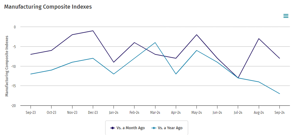
Kansas City Fed manufacturing activity declined moderately in September 2024. The month-over-month composite index was -8 in September, down from -3 in August and up from -13 in July. The composite index is an average of the production, new orders, employment, supplier delivery time, and raw materials inventory indexes. Manufacturing remains in a recession in the US.

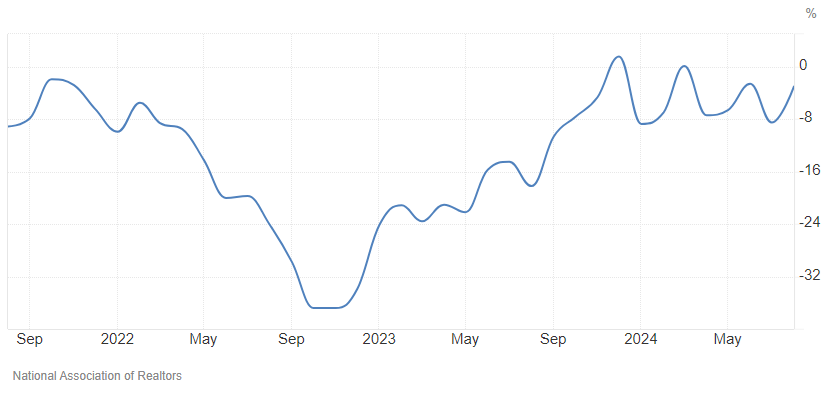
 Pending home sales in August 2024 were down 3.0% year-over-year. I know everyone is thinking the federal funds rate will make houses more affordable – but house price appreciation will offset these gains. NAR Chief Economist Lawrence Yun added:

A slight upward turn reflects a modest improvement in housing affordability, primarily because mortgage rates descended to 6.5% in August. However, contract signings remain near cyclical lows even as home prices keep marching to new record highs.

In the week ending September 21, the advance figure for seasonally adjusted initial unemployment claims 4-week moving average was 224,750, a decrease of 3,500 from the previous week’s revised average. The previous week’s average was revised up by 750 from 227,500 to 228,250. There is no indication of a recession or slowing economy in these numbers.

Here is a summary of headlines we are reading today:

  • Ranking the World’s Financial Centers
  • Russia Lowers Nuclear Threshold, Citing Western Threats
  • Oil Plunges Over 2% on Rumor Saudis Ready To Increase Output
  • Russia Could Scrap Gasoline Export Ban if Domestic Surplus Emerges
  • The Fed slashed interest rates last week, but Treasury yields are rising. What’s going on?
  • Dow jumps more than 250 points, S&P 500 closes higher to post fresh record: Live updates
  • David Tepper says the Fed has to cut rates at least two or three more times to keep credibility
  • Misinformation running rampant on Facebook has officials concerned about election disruptions
  • Hurricane Helene is upgraded to a Category 3 as it barrels toward Florida
  • Yield on 2-year Treasury logs biggest jump in five weeks after strong U.S. GDP report
  • A port strike would be ill-timed, but disruption could boost these companies

Click on the “Read More” below to access these, other headlines, and the associated news summaries moving the markets today.

World Agriculture Production, Supply, and Demand as provided by USDA in their September Report which I am publishing on September 26, 2024

We start with the Supply and Demand  Estimates which is an all-text discussion.

Then we look at  World Agriculture Production and here there are many interesting maps and graphs. Production is part of  Supply but Supply also includes the starting inventory and the ending inventory among other adjustments. So the two reports go together and I am presenting them that way.

There is so much here that I did not think that me adding comments would be helpful so I have refrained from doing that.

Some will need to click on “Read More to read the full article.

Weather Outlook for the U.S. for Today Through at Least 22 Days and a Six-Day Forecast for the World: posted September 26, 2024

This article focuses on what we are paying attention to in the next 48 to 72 hours. The article also includes weather maps for longer-term U.S. outlooks (up to four weeks) and a six-day World weather outlook which can be very useful for travelers.

First the NWS Short Range Forecast. The afternoon NWS text update can be found here after about 4 p.m. New York time but it is unlikely to have changed very much from the morning update. The images in this article automatically update.

Short Range Forecast Discussion
NWS Weather Prediction Center College Park MD
Thu Sep 26 2024
Valid 12Z Thu Sep 26 2024 – 12Z Sat Sep 28 2024

…Helene is forecast to rapidly intensify to a major hurricane in the
Gulf today and bring life-threatening impacts to Florida and the Southeast
through Friday…

…Rare High Risks of excessive rainfall are in place for parts of the
Florida Panhandle where Helene will make landfall, and for the southern
Appalachians where catastrophic flash flooding and landslides are
expected...

…Above average temperatures and summer-like warmth forecast to stretch
from the Southwest to northern Plains…

Hurricane Helene is moving northward through the Gulf of Mexico this
morning and is forecast to become a major hurricane before making
landfall. Potentially catastrophic hurricane-force winds are expected
within the eyewall of Helene when it makes landfall in the Florida Big
Bend region this evening. Because Helene is becoming a large system and
will initially move inland quickly, damaging and life-threatening
hurricane-force winds, especially in gusts, will penetrate well inland
over portions of northern Florida and southern Georgia late Thursday and
Thursday night where Hurricane Warnings are in effect. Strong wind gusts
are also likely farther north across portions of northern Georgia and the
Carolinas, particularly over the higher terrain of the southern
Appalachians. Additionally, catastrophic and deadly storm surge is likely
along portions of the Florida Big Bend coast, where inundation could reach
as high as 20 feet above ground level, along with destructive waves. There
is also a danger of life-threatening storm surge along the remainder of
the west coast of the Florida Peninsula. Prepare now and heed instructions
from local officials about evacuations in these areas. Please refer to the
National Hurricane Center for the latest updates on the track and timing
of Helene.

Helene will also cause significant rainfall and flooding threats. Even
ahead of Helene itself, tropical moisture continues to be pulled north
into the Southeast to southern Appalachians ahead of a slow-moving upper
trough/low and surface front, currently causing rainfall and flooding that
will last through the day. Heavy to extreme rainfall from yesterday has
also led to wet antecedent conditions in places where Helene will track. A
rare High Risk (level 4/4) remains in place in WPC’s Excessive Rainfall
Outlook (ERO) across portions of Georgia into the southern Appalachians
where upslope flow should increase rain totals and varying terrain is
likely to lead to landslides. Additionally, a separate area of extreme
rainfall is also likely near the core of the storm as it passes over the
Florida Panhandle, where a separate High Risk is in effect in the Day 1
ERO. A broad Slight Risk (level 2/4) with an embedded Moderate Risk (level
3/4) over the Appalachians is in place for Friday for continued rainfall.
Overall, Helene is forecast to produce total rain accumulations of 6 to 12
inches, with isolated totals around 20 inches, over portions of the
Southeast into southern Appalachians. Catastrophic and life-threatening
flash and urban flooding, including numerous significant landslides, is
expected across portions of the southern Appalachians through Friday.
Considerable to locally catastrophic flash and urban flooding is likely
for northwestern and northern Florida and the Southeast through Friday.
Widespread significant river flooding and isolated major river flooding
are likely. Another weather hazard associated with Helene to monitor is
the tornado threat, especially on the eastern side of the track. The Storm
Prediction Center is indicating a Slight to Enhanced Risk of severe
weather, primarily for tornadoes, today into tonight for parts of Florida
into Georgia and South Carolina/southeastern North Carolina.

Elsewhere, showers and storms are also possible farther north in the
eastern U.S. along the northern part of the frontal system over the next
couple of days. A couple of fronts passing through the Northwest should
lead to some precipitation there and gusty winds. Meanwhile the rest of
the western U.S. stretching into the north-central U.S. can expect dry
conditions with warmer than average temperatures. The Desert Southwest
will see highs well into the 100s and low 110s, which has prompted
Excessive Heat Warnings from south-central Arizona into the high deserts
of southern California. High into the 90s are likely in the northern High
Plains today, with 80s stretching into the Upper Midwest through the end
of the week. Record warm temperatures are possible for both morning lows
and afternoon highs.

cone graphic

https://www.nhc.noaa.gov/storm_graphics/AT09/refresh/AL0924WPCERO+gif/032536WPCERO_sm.gif

To get your local forecast plus active alerts and warnings click HERE and enter your city, state or zip code.


Learn about wave patterns HERE.

Then, looking at the world and of course, the U.S. shows here also. Today we are looking at precipitation.

Please click on “Read More” below to access the full Daily Report issued today.

25 SEPT 2024 Market Close & Major Financial Headlines: It Was All Downhill After The Dow And The S&P 500 Set New Historic Highs After The Opening Before Closing Moderately Lower

Summary Of the Markets Today:

  • The Dow closed down 293 points or 0.70%, (Closed at 41,915, New Historic high 42,300)
  • Nasdaq closed up 0.04%,
  • S&P 500 closed down 0.19%, (Closed at 5,722, New Historic high 5,741)
  • Gold $2,684 up $6.90,
  • WTI crude oil settled at $70 down $1.81,
  • 10-year U.S. Treasury 3.789 up 0.053 points,
  • USD index $100.98 up $0.51,
  • Bitcoin $63,274 down $1,030 or 1.60%,

*Stock data, cryptocurrency, and commodity prices at the market closing

Today’s Highlights

The stock market rally lost steam, with major indexes closing mixed after retreating from all-time highs reached yesterday. Investors are debating the health of the economy and the chances of another large interest rate cut following the Fed’s surprise 0.5% cut. Economic data was mixed – new home sales declined in August, but mortgage applications jumped to the highest level since 2022 as rates dropped. The focus is now on upcoming GDP data and the PCE inflation index report later this week.


Click here to read our current Economic Forecast – September 2024 Economic Forecast: One Recession Flag Removed With Three Remaining


Today’s Economic Releases Compiled by Steven Hansen, Publisher:

Human Resources Trends & Issues Survey conducted online among 182 HR executives and business leaders nationwide by global outplacement and business and executive coaching firm Challenger Gray & Christmas, Inc. found:

  • Cost-Cutting Measures: Companies are actively pursuing cost reductions as they approach the end of the year, focusing on travel, bonuses, salaries, and technology solutions. A survey found that 9% of organizations are using return-to-office policies as part of their cost-cutting strategies, reflecting a shift from traditional methods like layoffs
  • AI in the Workplace: There is a growing disconnect between employee usage of AI tools (37% of employees) and corporate policies, with only 12% of companies having formal AI training or strategies. This gap raises concerns about data security and ethical implications as employees navigate AI independently
  • Quiet Quitting Concerns: The phenomenon of “quiet quitting,” where employees disengage without resigning, is a significant worry for 33% of companies. However, many lack concrete evidence or tracking mechanisms to assess its impact accurately
  • Leadership Perception: Favorable views of leadership have slightly declined, with 54.55% of employees expressing positive opinions. There is an increase in mixed views and a notable rise in companies not tracking leadership perceptions
  • Employee Priorities: Flexibility remains the top priority for employees, followed by meaningful work and career advancement. While salary and empathetic leadership are still valued, their importance has decreased compared to previous surveys
  • Employer Offerings: Companies are adjusting their offerings in response to employee needs, with a focus on leadership development and DEI initiatives. However, financial incentives like signing bonuses have declined significantly
  • Remote Work Trends: The trend towards hybrid and remote work continues, with 54% of companies offering such arrangements. The model of requiring three days in the office has become more common
  • Hiring Challenges: Filling roles is becoming easier for some companies, though challenges remain, particularly in specialized fields like healthcare and technology. Despite improvements, 17% of companies are still in hiring freezes

Sales of new single-family houses in August 2024 were up 9.8% above the August 2023. The median sales price of new houses sold in August 2024 was $420,600. The average sales price was $492,700. The seasonally-adjusted estimate of new houses for sale at the end of August was 467,000. This represents a supply of 7.8 months at the current sales rate. New home sales remain a bright spot in the current economy.

Here is a summary of headlines we are reading today:

  • Wells Fargo: Oil Prices To Stay Depressed Through 2025 on Global Oversupply
  • Global Superpower Ranking Reveals Shifting Power Dynamics
  • Oil Prices Decline As Investors Weigh China Stimulus
  • Gold Prices Soar on Strong Demand From Hedge Funds and Central Banks
  • BlackRock Sees AI Driving a 50% Jump in Asian Energy Demand
  • Dow falls nearly 300 points to snap four-day win streak, S&P 500 retreats from record: Live updates
  • Mortgage refinance boom takes hold, as weekly demand surges 20%
  • Southwest Airlines to cut service and staffing in Atlanta to slash costs
  • Surging AI demand could cause the world’s next chip shortage, research says
  • Hidden Agendas: Beware Of The Government’s Push For A Digital Currency
  • A port strike could be an economic ‘tsunami’ affecting these sectors
  • The number of millionaire college athletes has tripled. Here are the top 10 earners this year.

Click on the “Read More” below to access these, other headlines, and the associated news summaries moving the markets today.

Weather Outlook for the U.S. for Today Through at Least 22 Days and a Six-Day Forecast for the World: posted September 25, 2024

This article focuses on what we are paying attention to in the next 48 to 72 hours. The article also includes weather maps for longer-term U.S. outlooks (up to four weeks) and a six-day World weather outlook which can be very useful for travelers.

First the NWS Short Range Forecast. The afternoon NWS text update can be found here after about 4 p.m. New York time but it is unlikely to have changed very much from the morning update. The images in this article automatically update.

Short Range Forecast Discussion
NWS Weather Prediction Center College Park MD
Wed Sep 25 2024
Valid 12Z Wed Sep 25 2024 – 12Z Fri Sep 27 2024

…Helene is forecast to rapidly intensify to a major hurricane in the
Gulf and bring life-threatening impacts to Florida and the Southeast late
today through Friday…

…A rare High Risk of excessive rainfall is in place for the southern
Appalachians Thursday-Thursday night where considerable flash/urban/river
flooding and landslides are possible…

Current Tropical Storm Helene is forecast to quickly become a hurricane
today and become a major hurricane before making landfall on Thursday. A
Hurricane Warning is in effect over the Florida Big Bend for damaging
hurricane-force winds. Helene will grow in size as it strengthens,
spreading its impacts to much of Florida and the Southeast. There is a
danger of life-threatening storm surge along the entire west coast of the
Florida Peninsula and Florida Big Bend. The highest inundation levels are
expected along the coast of the Florida Big Bend. Prepare now and heed
instructions from local officials about evacuations in these areas. Please
refer to the National Hurricane Center for the latest updates on the track
and timing of Helene.

Helene will also cause significant rainfall and flooding threats. Even
ahead of Helene itself, tropical moisture will be pulled north into the
Southeast to southern Appalachians today and tonight ahead of a
slow-moving upper trough/low. This moisture will pool along and ahead of a
stalling front at the surface and lead to excessive rainfall. A Moderate
Risk is in place in WPC’s Excessive Rainfall Outlook (ERO) across portions
of Georgia into the southern Appalachians today into tonight within a
broader Slight Risk, in addition to Slight Risks of flash flooding in
parts of the Florida Peninsula and West Coast as Helene approaches.
Today’s rainfall is forecast to create wet antecedent conditions that
should likely overlap heavy rain along Helene’s track Thursday-Friday.
Thus a High Risk of excessive rainfall is delineated across the southern
Appalachians where upslope flow should increase rain totals and varying
terrain could lead to landslides. Overall, 5 to 10 inches of rain with
isolated totals around 15 inches is forecast over the Southeast.
Considerable flash and urban flooding is expected across portions of
Florida, the Southeast, southern Appalachians, and the Tennessee Valley
Wednesday through Friday. This includes the risk of landslides across the
southern Appalachians. Widespread minor to moderate river flooding is
likely, and isolated major river flooding is possible. Additionally, there
is a tornado threat with Helene, especially on the eastern side of the
track. The Storm Prediction center is indicating a Slight to Enhanced Risk
of severe weather, primarily for tornadoes, on Thursday into Thursday
night for parts of Florida into Georgia and South Carolina.

Elsewhere, showers and storms are also possible farther north in the
eastern U.S. along the northern part of the frontal system over the next
couple of days. A couple of fronts passing through the Northwest should
lead to some precipitation there. Meanwhile the rest of the western U.S.
stretching into the north-central U.S. can expect dry conditions with
warmer than average temperatures. The Desert Southwest will see highs well
into the 100s, and 90s are possible in the northern High Plains. Some
record temperatures are possible for lows and highs.

cone graphic

To get your local forecast plus active alerts and warnings click HERE and enter your city, state or zip code.


Learn about wave patterns HERE.

Then, looking at the world and of course, the U.S. shows here also. Today we are looking at precipitation.

Please click on “Read More” below to access the full Daily Report issued today.