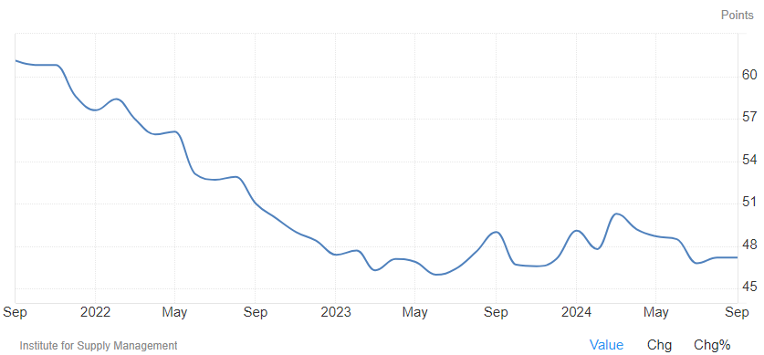
Weather Outlook for the U.S. for Today Through at Least 22 Days and a Six-Day Forecast for the World: posted October 2, 2024
This article focuses on what we are paying attention to in the next 48 to 72 hours. The article also includes weather maps for longer-term U.S. outlooks (up to four weeks) and a six-day World weather outlook which can be very useful for travelers.
First the NWS Short Range Forecast. The afternoon NWS text update can be found here after about 4 p.m. New York time but it is unlikely to have changed very much from the morning update. The images in this article automatically update.
Short Range Forecast Discussion
NWS Weather Prediction Center College Park MD
Wed Oct 02 2024
Valid 12Z Wed Oct 02 2024 – 12Z Fri Oct 04 2024….There is a Marginal Risk of excessive rainfall over parts of the
Central Gulf Coast on Thursday……There is a Critical Risk of fire weather over parts of the Central High
Plains/Central Rockies on Wednesday……There are Excessive Heat Warnings and Heat Advisories over parts of
Southern California and the Southwest…A front extending from the Lower Great Lakes to the Central Appalachians
to the Central Gulf Coast moves eastward to the Northeast and dissipates.
On Wednesday, the front will produce light rain over parts of the Lower
Great Lakes, Central Appalachians, and Mid-Atlantic. The light rain will
end overnight Wednesday. In addition, showers and thunderstorms will
develop over parts of Florida through Friday.On Thursday, tropical moisture will start to build over the
Central/Eastern Gulf Coast and Florida. Upper-level energy over the
Western Gulf Coast and Northern Gulf of Mexico will move into parts of the
Southeast and Central Gulf Coast, producing moderate to heavy rain over
parts of the Central Gulf Coast. Therefore, the WPC has issued a Marginal
Risk (level 1/4) of excessive rainfall over parts of the Central Gulf
Coast from Thursday into Friday morning. The associated heavy rain will
create localized areas of flash flooding, affecting areas that experience
rapid runoff with heavy rain. Light rain and showers will also develop
over parts of the Southeast/southern Mid-Atlantic on Thursday into Friday.Meanwhile, a front extending from the Northern Plains to parts of the
Pacific Northwest will move eastward to the Great Lakes and southward to
the Central Plains by Thursday evening. As the boundary continues to move
eastward, light rain will develop over parts of the Middle Mississippi
Valley and expand into the Upper Great Lakes by Friday.Furthermore, down-slope flow over parts of the Northern/Central Rockies
will create warm air over parts of the Central Rockies, combined with
strong gust wind and dry fuels, which have prompted a Critical Risk of
fire weather over parts of the Central Rockies on Wednesday.Moreover, the upper-level ridge over the Four Corners Region will create
high temperatures over Southern California and the Southwest, ranging from
the upper 90s to 110s. Low temperatures will be in the upper 80s to low
90s, providing little relief from the heat overnight. The temperatures
have prompted Excessive Heat Warnings and Heat Advisories over parts of
Southern California and the Southwest.Record-breaking heat is expected across portions of the Southwest this
week. Moderate to major heat impacts are possible in areas near San
Francisco, Las Vegas, and Los Angeles. Extreme Heat Risk impacts are
forecast in Phoenix. Remember, Heat is the Deadliest Weather Phenomenon in
the U.S.! People spending more time outdoors or in a building without
cooling are at an increased risk of heat-related illness. Visit
www.weather.gov/safety/heat and check local media and government websites
for information on cooling centers.
To get your local forecast plus active alerts and warnings click HERE and enter your city, state or zip code.