NOAA Updates their Mid-Month Forecast for November 2024 on October 31, 2024 – Major Changes. – Posted on November 1, 2024

At the end of every month, NOAA updates its Outlook for the following month which in this case is November of 2024. We are reporting on that tonight. In this article, I refer to November, 2024 as “The New Month”.

There have been significant changes in the Outlook for the new month and these are addressed in the NOAA Discussion so it is well worth reading.  We provided the prior Mid-Month Outlook for the new  month for comparison. It is easy to see the substantial changes in the weather outlook by comparing the Mid-Month and Updated Maps.

The article includes the Drought Outlook for the new month. NOAA also adjusted the previously issued three-month Drought Outlook to reflect the changes in the new month’s Drought Outlook. We also provide the Week 2/3 Tropical Outlook for the World. The Tropical Outlet includes both direct and indirect potential impacts to the Southern Tier of CONUS. We also include a whole set of the forecasts for parts of the new month. These are both useful and provide a crosscheck on the validity of the new month’s Outlook. The whole should be equal to the sum of its parts.

The best way to understand the updated outlook for the new month is to view the maps and read the NOAA discussion. I have highlighted the key statements in the NOAA Discussion.

I am going to start with graphics that show the updated Outlook for the new month and the earlier Mid-Month Outlook for the new month. This is followed by a graphic that shows both the Updated Outlook for the new month and the previously issued three-month outlook for the three-month period that includes the new month. So you get the full picture in three graphics.

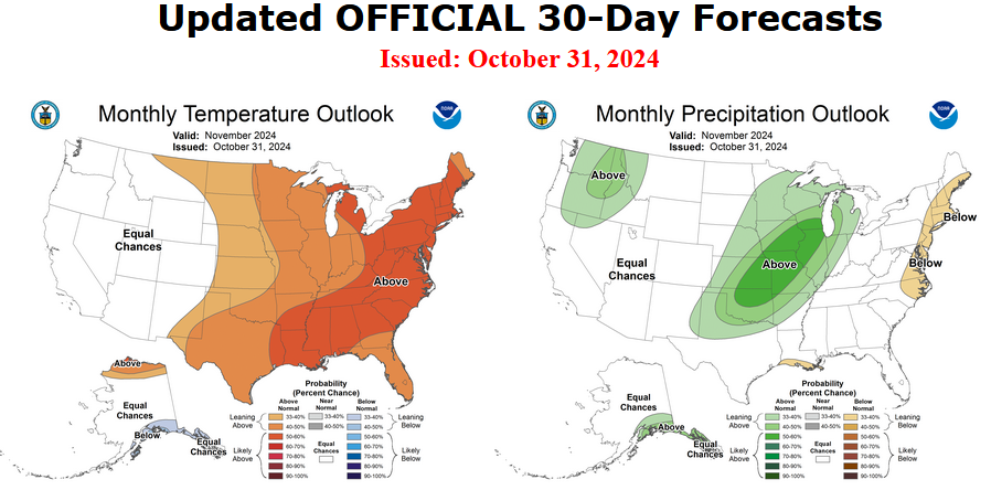
Here is the updated Outlook for November 2024.

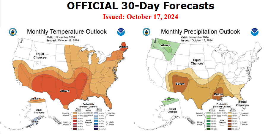
For Comparison Purposes, Here is the earlier Mid-Month Outlook for November

It is important to remember that the maps show deviations from the current definition of normal which is the period 1991 through 2020.  So this is not a forecast of the absolute value of temperature or precipitation but the change from what is defined as normal or to use the technical term climatology.

It is a substantial change from what was issued on October 17, 2024. Remember, it is the first set of maps that are the current outlook for November which is the new month.  One expects some changes  14 days later. However, the changes to the updated new month Outlook are very significant.  This then gives us some reason to question the (October 17, 2024) three-month NDJ temperature and precipitation Outlooks which are shown in the following graphic.

NOAA provided a combination of the Updated Outlook for the New Month and the Three-Month Outlook.

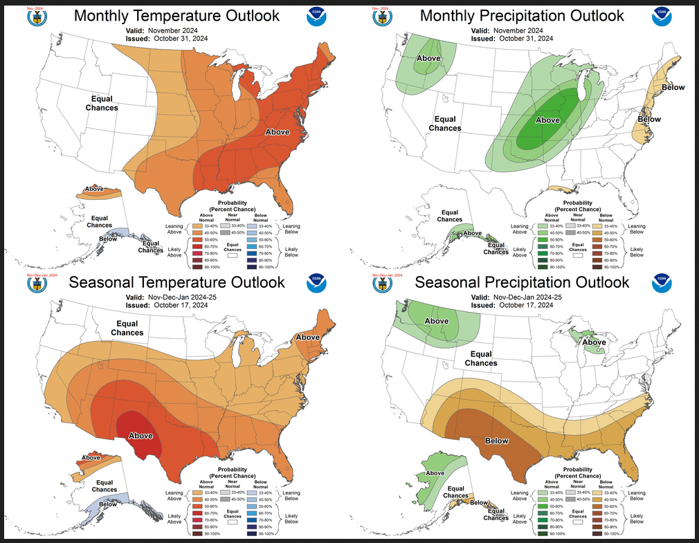
The top pair of maps are again the Updated Outlook for the new month. There is a temperature map and a precipitation map. The bottom row shows the three-month outlooks which includes the new month. I think the outlook maps are self-explanatory.

To the extent that one can rely on a forecast, we would conclude that December and January will be very different than November. You can subtract November from the three-month Outlook and divide by two to get a combined December/January Outlook.

However given the major change in the new Outlook outlook from what was issued on October 17,  2024, we might not trust the three-month Outlook issued on October 17, 2024. Something to think about. But the major factor is the projected slower onset of La Nina. Thus this change may be consistent with the pattern the NOAA has been predicting although they have been playing catch-up.

I am still not convinced that there will be a La Nina Winter. Thus I am somewhat skeptical about the NOAA Outlooks.

Some readers may need to click “Read More” to read the rest of the article.  Some will feel that they have enough information. But there is a lot more information in the rest of this article.

Weather Outlook for the U.S. for Today Through at Least 22 Days and a Six-Day Forecast for the World: posted November 1, 2024

This article focuses on what we are paying attention to in the next 48 to 72 hours. The article also includes weather maps for longer-term U.S. outlooks (up to four weeks) and a six-day World weather outlook which can be very useful for travelers.

First the NWS Short Range Forecast. The afternoon NWS text update can be found here after about 4 p.m. New York time but it is unlikely to have changed very much from the morning update. The images in this article automatically update.

Short Range Forecast Discussion
NWS Weather Prediction Center College Park MD
Fri Nov 01 2024
Valid 12Z Fri Nov 01 2024 – 12Z Sun Nov 03 2024

…Threat of a heavy rain and severe weather event increasing across the
central to southern Plains throughout the weekend…

…Mountain snow will overspread from the Pacific Northwest into much of
the Intermountain West over the next couple of days with heavy rain today
near the Pacific Northwest coast…

…Much above average temperatures expected across large portions of the
central to eastern U.S. with little rain in sight along the East Coast…

A trailing cold front in connection with a low pressure system currently
moving east across the Great Lakes toward New England will bring a chance
of rain into the eastern U.S. on this first day of November following an
exceptionally dry October for this part of the country. However, it
appears that the rain will not progress much beyond the Appalachians today
as another day of warm and dry conditions is forecast for the East Coast.
In fact, the warm temperatures into the 70s early this morning have
already challenged high temperature records for November in upstate New
York. In addition, record high morning lows are possible this morning
from the Mid-Atlantic into New England and record high temperatures are
possible Friday afternoon from near New York City to northern Maine. The
cold front will bring gusty winds and cool temperatures into the Northeast
by tonight and into the weekend. While less record temperatures are
forecast over the next few days across the eastern two-thirds of the
country, widespread above average temperatures expected across large
portions of the central to eastern U.S.

A high pressure system will build across the Northeast during the weekend
and will sustain the dry conditions down the Eastern Seaboard for the
first few days of November. Attention will then focus across the central
and southern Plains as a rather significant heavy rain and severe weather
event will be emerging throughout the weekend. As moist air from the Gulf
of Mexico returns and streams northward into the southern Plains behind
the high pressure system, a deepening upper-level trough will be moving
through the western U.S. This trough will bring another round of heavy
rain near the coast for Pacific Northwest today before spreading more
mountain snow across the Intermountain West through the weekend.
Southwesterly flow ahead of the trough will then interact with the
returning Gulf moisture over the southern Plains and lift the moisture
over a warm front. It appears that moderate to heavy rain associated with
organized thunderstorms will first develop over the southern High Plains
tonight. The thunderstorms and heavy rain will then expand northeastward
into the central Plains through the weekend. A few inches of heavy rain
with locally higher amounts is forecast across the southern Plains, with
the heaviest rains expected across central Oklahoma. Similar to many
areas of the Lower 48, this region is experiencing moderate to extreme
drought conditions. While this round of heavy rain will help aleviate the
drought, the high rainfall rates will also bring an increasing threat of
flash flooding. Please keep abreast of the latest forecast updates on
this upcoming heavy rain/severe weather event across the central to
southern Plains.

To get your local forecast plus active alerts and warnings click HERE and enter your city, state or zip code.

Learn about wave patterns HERE.

Then, looking at the world and of course, the U.S. shows here also. Today we are looking at precipitation.

Please click on “Read More” below to access the full Daily Report issued today.

31 OCT 2024 Market Close & Major Financial Headlines: Spooky Markets Opened Lower, S&P 500 Loses Almost 1.5% Because of Microsoft And Meta, Nasdaq Follows, Closing With Almost A 2.8% Drop

Summary Of the Markets Today:

  • The Dow closed down 378 points or 0.90%,
  • Nasdaq closed down 513 points or 2.76%,
  • S&P 500 closed down 108 points or 1.86%,
  • Gold $2,757 down $44.20 or 1.59%,
  • WTI crude oil settled at $71 up $1.93 or 2.81%,
  • 10-year U.S. Treasury 4.282 up 0.016 points or 0.113%,
  • USD index $103.90 down $0.01 or 0.01%,
  • Bitcoin $69,969 down $1,973 or 2.82%, (24 Hours)

*Stock data, cryptocurrency, and commodity prices at the market closing

Today’s Highlights

The US stock market experienced a significant decline on Thursday, led by the tech-heavy Nasdaq Composite. The S&P 500 and the Dow Jones ended October slightly in the red. Big Tech Earnings Concerns Meta and Microsoft’s earnings reports sparked worries about Big Tech prospects. Both companies beat Wall Street estimates but flagged increased spending on AI infrastructure. Concerns about pressure on profitability led to share price drops for Meta and Microsoft. This unsettled mood affected other tech giants like Amazon, Apple, and Nvidia. Amazon and Apple are set to report earnings after market close today. Bond yields surged, with the 10-year Treasury yield climbing to 4.33%. The Personal Consumption Expenditures (PCE) index showed core inflation at 2.7% annually in September, higher than expected.


Click here to read our current Economic Forecast – November 2024 Economic Forecast: Our Index Marginally Declines – We Are Stuck With The Crappy Economy We Have Seen So Far This Year


Today’s Economic Releases Compiled by Steven Hansen, Publisher:

NFIB’s October jobs report found that 35% (seasonally adjusted) of small business owners reported job openings they could not fill in October, up one point from September’s lowest reading since January 2021. The percent of small business owners reporting labor quality as their top operating problem rose three points from September to 20%. NFIB Chief Economist Bill Dunkelberg added:

On Main Street, the job market remains challenging. Although the labor market appears to be softening overall, small business owners reported little success filling their plentiful vacancies in October.

The Chicago Business Barometer dropped 5.0 points to 41.6 in October 2024 after edging up for two consecutive months, making the barometer the lowest since May 2024, and 1.6 points below the year-to-date average. Not sure what is going on here as I would call this a recession flag EXCEPT it is a survey – not fact but opinion.

Real Disposable Personal Income is up3.1% year-over-year (unchanged from last month) whilst Real Personal Consumption Expenditures is up 3.1% year-over-year (up from 3.0% from last month). Inflation measured by the PCE price index is 2.1% (improved from 2.3% last month) whilst the all important PCE price index less food and energy was little changed at 2.7%. This data was a touch stronger than I expected by aligns with the slight improvement in my October Economic Forecast. Also note that the inflation index used by the Federal Reserve (the one less food and energy) was little changed.

In the week ending October 26, the advance figure for seasonally adjusted initial unemployment claims 4-week moving average was 236,500, a decrease of 2,250 from the previous week’s revised average. The previous week’s average was revised up by 250 from 238,500 to 238,750. This unemployment data is not recessionary.

U.S.-based employers announced 55,597 cuts in October 2024, down 23.7% from the 72,821 cuts announced one month prior. It is 51% higher than the 36,836 cuts announced in the same month in 2023. October’s total marks the seventh time this year job cut announcements are higher than the corresponding month one year prior. These numbers are somewhat elevated and support my position that economic growth is weak.

Here is a summary of headlines we are reading today:

  • Aston Martin’s Pre-Tax Losses Plummet by 90% in Q3
  • North Korea’s Surprise Involvement in Ukraine War is Bad News for China
  • Record Shale Production Helps ConocoPhillips Beat Profit Estimates
  • Oil Prices Rebound, But Henry Hub Nat Gas Still Taking a Beating
  • New Survey Shows Grim Outlook For Oil Markets
  • Regulatory Uncertainty Casts Shadow Over U.S. LNG Industry
  • IMF Cuts Middle East Growth Outlook on Oil Output Cuts and Conflicts
  • Amazon shares pop on earnings beat, cloud growth
  • Intel shares pop 12% on earnings beat, uplifting guidance
  • Microsoft’s stock has worst day in two years after disappointing forecast
  • Key inflation rate hits 2.1% in September, as expected, closing in on Fed target
  • Bitcoin retreats to $70,000 to close out October: CNBC Crypto World
  • Coinbase drops 15% after earnings, posts worst day in more than two years
  • Stock market suffers a Halloween selloff as tech investors get the chills

Click on the “Read More” below to access these, other headlines, and the associated news summaries moving the markets today.

November 2024 Economic Forecast: Our Index Marginally Declines – We Are Stuck With The Crappy Economy We Have Seen So Far This Year

Authored by Steven Hansen

EconCurrent‘s Economic Index marginally declined with a downwardly revised September forecast and again returned to negative territory. Inflation overall remains unchanged compared to last two months – a strange situation after the Federal Reserve declared progress on curtailing inflation. Currently, we do not forecast a recession in the near term. Read on to understand the currents affecting our economic growth.

Weather Outlook for the U.S. for Today Through at Least 22 Days and a Six-Day Forecast for the World: posted October 31, 2024

This article focuses on what we are paying attention to in the next 48 to 72 hours. The article also includes weather maps for longer-term U.S. outlooks (up to four weeks) and a six-day World weather outlook which can be very useful for travelers.

First the NWS Short Range Forecast. The afternoon NWS text update can be found here after about 4 p.m. New York time but it is unlikely to have changed very much from the morning update. The images in this article automatically update.

Short Range Forecast Discussion
NWS Weather Prediction Center College Park MD
Thu Oct 31 2024
Valid 12Z Thu Oct 31 2024 – 12Z Sat Nov 02 2024

…Moderate to heavy snow over parts of the Southern Cascades and Northern
Intermountain Region, with a second area over parts of the Upper Midwest
on Thursday…

…Temperatures will be 20 to 25 degrees above average over parts of the
Lower Great Lakes/eastern Ohio Valley and the Northeast/Mid-Atlantic…

…There is a Marginal Risk of severe thunderstorms over parts of the
Ohio/Tennessee Valley and Lower Mississippi Valley and a Marginal Risk of
excessive rainfall over parts of the Lower Mississippi Valley on
Thursday…

A wave of low pressure over the Upper/Middle Mississippi Valley will move
northeastward to Southeastern Canada by Friday. The trailing front moves
off the Northeast/Mid-Atlantic Coast by Friday evening, while the western
end of the boundary slowly moves northward as a stationary front over
north-central Texas by Saturday. Ahead of the front, temperatures will be
20 to 25 degrees above average over parts of the Lower Great Lakes/eastern
Ohio Valley and the Northeast/Mid-Atlantic.

On Thursday, moist air flowing northward over the Plains will extend into
the Great Lakes, creating showers and strong to severe thunderstorms ahead
of the front over parts of the Ohio/Tennessee Valley and Lower Mississippi
Valley. Therefore, the SPC has issued a Marginal Risk (level 1/5) of
severe thunderstorms over the Ohio/Tennessee Valley and Lower Mississippi
Valley through Friday morning. The hazards associated with these
thunderstorms are frequent lightning, severe thunderstorm wind gusts,
hail, and a minimal threat of tornadoes.

Furthermore, moderate to heavy rain will develop along the front over
parts of Tennessee and Lower Mississippi Valleys. Therefore, through
Friday morning, the WPC has issued a Marginal Risk (level 1/4) of
excessive rainfall over parts of the Tennessee and Lower Mississippi
Valleys. The associated heavy rain will create localized areas of flash
flooding, affecting areas that experience rapid runoff with heavy rain.

Moreover, the wave of low pressure will pull cold air over parts of the
Upper Midwest, producing moderate to heavy snow over parts of Minnesota,
extreme northern Wisconsin, and portions of the Upper Peninsula of
Michigan. Furthermore, rain develops along the front from Central
Appalachians to the Northeast on Friday morning, tapering off to scattered
rain over parts of the Northeast by Friday evening. Also, on Friday,
onshore flow off the Atlantic will produce scattered rain over parts of
Florida.

On Friday, the threat of strong to severe thunderstorms moves westward to
the Southern High Plains as upper-level dynamics move over Southern
California. Therefore, the SPC has issued a Marginal Risk (level 1/5) of
severe thunderstorms over parts of the Southern High Plains from Friday
into Saturday morning. The hazards associated with these thunderstorms are
frequent lightning, severe thunderstorm wind gusts, hail, and a minimal
threat of tornadoes

Further, the showers and thunderstorms will create moderate to heavy rain
over parts of the Southern Plains. Therefore, the WPC has issued a
Marginal Risk (level 1/4) of excessive rainfall over parts of the Southern
Plains from Friday to Saturday morning. The associated heavy rain will
create localized areas of flash flooding, affecting areas that experience
rapid runoff with heavy rain.

Meanwhile, another front over the Pacific Northwest and California will
move inland and dissipate by Thursday evening. On Thursday, the snow will
become moderate to heavy over parts of the Southern Cascades and Northern
Intermountain Region. Rain will continue over the Northwest and
Northern/Central California through early Saturday. Light snow will
continue over parts of the higher elevations of the Cascades, Sierra
Nevada Mountains, Northern Intermountain Region, and Northern Rockies.

To get your local forecast plus active alerts and warnings click HERE and enter your city, state or zip code.

Learn about wave patterns HERE.

Then, looking at the world and of course, the U.S. shows here also. Today we are looking at precipitation.

Please click on “Read More” below to access the full Daily Report issued today.

30 OCT 2024 Market Close & Major Financial Headlines: Markets Opened Lower, Then Trended Into The Green Briefly Before Reversing Course Before Closing Moderately Down In The Red

Summary Of the Markets Today:

  • The Dow closed down 92 points or 0.22%,
  • Nasdaq closed down 105 points or 0.56%, (Closed at 18,608, New Historic high 18,785)
  • S&P 500 closed down 19 points or 0.33%,
  • Gold $2,798 up $17.10 or 0.63%,
  • WTI crude oil settled at $69 up $1.71 or 2.53%,
  • 10-year U.S. Treasury 4.280 up 0.006 points or 0.051%,
  • USD index $104.06 down $0.25 or 0.24%,
  • Bitcoin $71,820 down $3,878 or 0.54%, (24 Hours)

*Stock data, cryptocurrency, and commodity prices at the market closing

Today’s Highlights

The major US stock indexes closed lower after fluctuating throughout the trading session. Alphabet’s (GOOG, GOOGL) strong quarterly results boosted optimism for Big Tech with Alphabet shares jumping nearly 3% Amazon (AMZN), Meta (META), and Microsoft (MSFT) saw smaller gains Investors eagerly await after-hours earnings reports from Meta and Microsoft. Fresh economic data provided mixed signals: US economic growth slowed to a 2.8% annualized rate last quarter, slightly below forecasts Consumer spending remained robust as inflation continued to fall. ADP report showed a surge in US private payroll growth for October. Reddit (RDDT) stock soared over 40% after reporting its first-ever profit as a public company and beating revenue expectations.


Click here to read our current Economic Forecast – October 2024 Economic Forecast: One More Recession Flag Removed Yet Little Headway On Inflation


Today’s Economic Releases Compiled by Steven Hansen, Publisher:

Private employers added 233,000 jobs in October 2024 according to ADP. The largest growth was in the services sector with the manufacturing sector losing 19,000 jobs. Even I am surprised at the high jobs growth for a variety of reasons. This boosts the chance that Friday’s jobs report from the BLS will be strong also. Nela Richardson, Chief Economist ADP opinion:

Even amid hurricane recovery, job growth was strong in October. As we round out the year, hiring in the U.S. is proving to be robust and broadly resilient.

The advance estimate of 3Q2024 Real Gross Domestic Product (GDP) came in at 2.7% growth year-over-year – down from the 2Q2024’s 3.0%. The inflation indicator (Implicit Price Deflator) moderated from 2.6% year-over-year to 2.2%. It appears that inflation in the elements that make up GDP are moderating – all whilst GDP is slowing. Remember buying anything used (most houses and cars sold are used) or imported items ares not included in GDP, and insurance and payouts in GDP is somewhat complex. But tomorrows Personal Income and Expenditures DOES include used and imported items. All this is why GDP is not an important metric for Joe and Jane Sixpack to understand how the economy is doing for them personally.

Pending home sales in September 2024 increased by 2.6% year-over-year, the first increase since March, and the fastest increase since May 2021. Literally, pending home sales since 2022 have been down 25% from the previous 10 year period. I can see no recovery for home sales without some combination of lower mortgage rates and/or home prices.

Here is a summary of headlines we are reading today:

  • Hess Beats Q3 Earnings Estimates On Robust Guyana Output
  • U.S. Governors Demand Power Price Overhaul As Costs Balloon 10 Fold
  • Mapping the Flow of Goods Through the Taiwan Strait
  • Oil Steady After EIA Confirms Draw in Crude, Gasoline Inventories
  • The West Needs Incentives to Cut Russian Nuclear Fuel Dependence
  • Microsoft beats on top and bottom lines, driven by better-than-expected cloud growth
  • Meta beats on top and bottom lines but misses user growth expectations
  • Super Micro shares plunge 33% as auditor resigns after raising concerns months earlier
  • Reddit shares close up 42% on profitability, rosy guidance
  • Inflation is cooling, yet many Americans are still living paycheck to paycheck
  • U.S. economy grew at a 2.8% pace in the third quarter, less than expected
  • Here’s why some NBA teams show their games on TV for free, while others charge fans hundreds of dollars

Click on the “Read More” below to access these, other headlines, and the associated news summaries moving the markets today.

Weather Outlook for the U.S. for Today Through at Least 22 Days and a Six-Day Forecast for the World: posted October 30, 2024

This article focuses on what we are paying attention to in the next 48 to 72 hours. The article also includes weather maps for longer-term U.S. outlooks (up to four weeks) and a six-day World weather outlook which can be very useful for travelers.

First the NWS Short Range Forecast. The afternoon NWS text update can be found here after about 4 p.m. New York time but it is unlikely to have changed very much from the morning update. The images in this article automatically update.

Short Range Forecast Discussion
NWS Weather Prediction Center College Park MD
Wed Oct 30 2024
Valid 12Z Wed Oct 30 2024 – 12Z Fri Nov 01 2024

…Moderate to heavy snow over parts of the Southern Cascades and Northern
Intermountain Region with a second area over parts of the Upper Midwest on
Thursday…

…Temperatures will be 20 to 30 degrees above average over parts of the
Great Lakes/Ohio Valley…

…There is an Enhanced Risk of severe thunderstorms over parts of the
Middle Mississippi Valley and Central/Southern Plains on Wednesday…

A wave of low pressure along a front over the Southern High Plains will
move northeastward to eastern Quebec, Canada, by Friday. Ahead of the
front, temperatures will be 20 to 30 degrees above average over parts of
the Great Lakes/Ohio Valley. A warm front over Northern New England will
move northeastward into Southeastern Canada by Thursday. Ahead of the warm
front, rain will develop over parts of Northern New England, ending by
Wednesday evening.

On Wednesday, moist air flowing northward over the Plains will extend into
the Upper Great Lakes, creating showers and severe thunderstorms will
develop ahead of the front over parts of the Middle Mississippi Valley and
Central/Southern Plains. Therefore, the SPC has issued an Enhanced Risk
(level 3/5) of severe thunderstorms over the Central Plains through
Saturday morning. The hazards associated with these thunderstorms are
frequent lightning, severe thunderstorm wind gusts, hail, and a few
tornadoes.

Moreover, southeasterly flow off the Gulf of Mexico will create scattered
showers and thunderstorms over parts of the Western Gulf Coast from
Tuesday into Wednesday. Similarly, easterly flow off the Atlantic will
produce showers and thunderstorms over parts of Florida through Thursday
morning. In addition, there is an increased threat of EF2 � EF5
tornadoes over the areas.

Furthermore, moderate to heavy rain will develop along the front over
parts of the Mississippi Valley and the Central/Southern Plains.
Therefore, the WPC has issued a Marginal Risk (level 1/4) of excessive
rainfall over parts of the Mississippi Valley and parts of the
Central/Southern Plains through Thursday morning. The associated heavy
rain will create localized areas of flash flooding, affecting areas that
experience rapid runoff with heavy rain.

On Thursday, the threat of severe thunderstorms from the Great Lakes to
the Lower Mississippi Valley will decrease to strong to severe
thunderstorms. Therefore, the SPC has issued a Marginal Risk (level 1/5)
of severe thunderstorms over parts of the Great Lakes to the Lower
Mississippi Valley from Thursday into Friday morning. The hazards
associated with these thunderstorms are frequent lightning, severe
thunderstorm wind gusts, hail, and a few tornadoes.

Further, the showers and thunderstorms will create heavy rain over parts
of the Tennessee and Lower Mississippi Valleys. Therefore, the WPC has
issued a Marginal Risk (level 1/4) of excessive rainfall over parts of the
Tennessee and Lower Mississippi Valleys from Thursday to Friday morning.
The associated heavy rain will create localized areas of flash flooding,
affecting areas that experience rapid runoff with heavy rain. In addition,
onshore flow from the Gulf of Mexico and the Atlantic will produce showers
and thunderstorms over parts of the Central/Western Gulf Coast and Florida.

Moreover, the wave of low pressure will pull cold air over parts of the
Upper Midwest, producing moderate to heavy snow over parts of Minnesota,
extreme northern Wisconsin, and the western portions of the Upper
Peninsula of Michigan. All these areas will be near Lake Superior on
Thursday, tapering off by Friday.

Meanwhile, another front will come onshore over the Pacific Northwest and
California on Wednesday, dissipating by Thursday evening. From late
Wednesday morning into Friday, the system will produce rain and
higher-elevation snow over parts of the Northwest into Northern/Central
California. On Thursday, the snow will become moderate to heavy over parts
of the Southern Cascades and Northern Intermountain Region.

To get your local forecast plus active alerts and warnings click HERE and enter your city, state or zip code.

Learn about wave patterns HERE.

Then, looking at the world and of course, the U.S. shows here also. Today we are looking at precipitation.

Please click on “Read More” below to access the full Daily Report issued today.

Correctly Assessing President Bill Clinton

Correctly Assessing President Bill Clinton

President Clinton left office in January 2001 but has maintained great influence over the Democratic Party since then. With another critical Presidential election imminent, let me correctly assess his 8-year Presidency, highlighted as follows:

  • Overall, was he a good President? No! He was mediocre at best!
  • Have both his immediate predecessor and successor made him look better? Yes!

29 OCT 2024 Market Close & Major Financial Headlines: The Dow Slips Into The Red, Bitcoin Almost Makes A New High, Nasdaq Records Fresh Record High, Small Caps Close Moderately Higher In The Green

Summary Of the Markets Today:

  • The Dow closed down 155 points or 0.36%,
  • Nasdaq closed up 146 points or 0.78%, (Closed at 18,713, New Historic high 18,753
  • S&P 500 closed up 9 points or 0.16%,
  • Gold $2,785 up $29.30 or 1.06%,
  • WTI crude oil settled at $67 down $0.14 or 0.21%,
  • 10-year U.S. Treasury 4.260 up 0.018 points or 0.148%,
  • USD index $104.29 down $0.02 or 0.02%,
  • Bitcoin $72,451 up $2,884 or 3.98%, (24 Hours)

*Stock data, cryptocurrency, and commodity prices at the market closing

Today’s Highlights

The tech-heavy Nasdaq Composite closed at a record high. The S&P 500 followed the NASDAQ’s lead but the Dow Jones Industrial Average was the only major index to close in the red, falling around 0.4%. Tech Stocks led the market gains, with Broadcom surging over 4% on news of a collaboration with Microsoft-aligned OpenAI. Investors absorbed a wave of earnings reports, with particular focus on upcoming results from tech giants. Alphabet’s highly anticipated results due after market close, are seen as a potential indicator of Big Tech’s AI investments paying off. Gold and silver prices rallied, with gold touching new highs near $2,770 per ounce. The U.S. presidential election is adding some uncertainty to markets in the final days of campaigning.


Click here to read our current Economic Forecast – October 2024 Economic Forecast: One More Recession Flag Removed Yet Little Headway On Inflation


Today’s Economic Releases Compiled by Steven Hansen, Publisher:

The number of CEO changes at U.S. companies rose slightly to 202 in September from 200 one month prior. It is up 23% from 164 CEO exits recorded in the same month last year, according to a report released Tuesday by global outplacement and business and executive coaching firm Challenger, Gray & Christmas, Inc. So far this year, 1,652 CEOs have announced their departures, the highest year-to-date total on record, since Challenger began tracking CEO changes in 2002.

The S&P CoreLogic Case-Shiller 20-City Composite posted a year-over-year increase of 5.2% in August 2024, dropping from a 5.9% increase in the previous month. Generally, home price increases peak in March and decline for the rest of the year – so it comes as no surprise that inflation is moderating in August. Here is the perspective of CoreLogic Chief Economist Dr. Selma Hepp:

Despite much-needed optimism, brought by a sharp decline in mortgage rates in August, the boost was short lived and not enough to renew homebuyers’ interest. As a result, home prices continued to weaken relative to their seasonal trend and year-over- year gains took a step back. Nevertheless, bifurcation in housing demand and price growth remained with the West and South seeing stronger slowdown in home prices and Northeast and Midwest continuing to see home price gains remaining robust. The tale of two regions reflects significant affordability challenges in the West and South, where home price surge in recent years and high mortgage rates priced out many potential buyers, while the Northeast and Midwest continue to benefit from relative affordability and less collective increase in prices over the last few years, but also more limited for-sale inventory.

The number of job openings was little changed at 7.4 million on the last business day of September. Over the month, hires changed little at 5.6 million. The number of total separations was unchanged at 5.2 million. There is a general correlation between job openings and employment increases. The graph below shows that since March 2023, the year-over-year decline has been in a narrow range – but all the same it is a decline. One would expect that employment growth should continue to moderate IF the way job openings is counted does not include phantom job openings (and the phantom job openings are the ones being removed). 

The Conference Board Consumer Confidence Index® increased in October to 108.7 (1985=100), up from 99.2 in September. Dana M. Peterson, Chief Economist at The Conference Board perspective:

Consumer confidence recorded the strongest monthly gain since March 2021, but still did not break free of the narrow range that has prevailed over the past two years. In October’s reading, all five components of the Index improved. Consumers’ assessments of current business conditions turned positive. Views on the current availability of jobs rebounded after several months of weakness, potentially reflecting better labor market data. Compared to last month, consumers were substantially more optimistic about future business conditions and remained positive about future income. Also, for the first time since July 2023, they showed some cautious optimism about future job availability.  October’s increase in confidence was broad-based across all age groups and most income groups. In terms of age, confidence rose sharpest for consumers aged 35 to 54. On a six-month moving average basis, householders aged under 35 and those earning over $100K remained the most confident.

Here is a summary of headlines we are reading today:

  • NATO Chief Confirms North Korean Troops in Russia’s Kursk Region
  • U.S. To Buy 3 Million Barrels for The SPR, But There’s A Problem
  • Small Nuclear Reactors to Power Czech Republic’s Green Energy Shift
  • Ford’s Q3 Earnings: A Mixed Bag for Investors
  • Gold’s Record High Suggests Inflation Isn’t Over Just Yet
  • Alphabet beats on top and bottom lines, boosted by cloud revenue
  • Consumer confidence surges as election nears, while job openings move lower
  • Crypto company Consensys cuts 20% of workforce, citing regulatory uncertainty: CNBC Crypto World
  • 10-year Treasury yield crosses ‘line in the sand’ that begins to spell trouble for stocks
  • 10-year Treasury yield closes below 4.3% after Tuesday’s initial selloff fades
  • Oil prices edge down to finish at lowest in seven weeks

Click on the “Read More” below to access these, other headlines, and the associated news summaries moving the markets today.