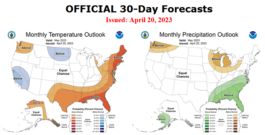
On the third Thursday of the month right on schedule NOAA issued what I describe as their Four-Season Outlook. The information released also included the Mid-Month Outlook for the single month of May plus the weather and drought outlook for the next three months. I present the information issued and try to add context to it. It is quite a challenge for NOAA to address the subsequent month, the subsequent three-month period as well as successive three-month periods for a year or a bit more.
It is very useful to read the excellent discussion that NOAA issues with this Seasonal Outlook. It is best to read the full discussion but here are some of the highlights:
- ENSO-neutral conditions are expected to continue through the Northern Hemisphere spring, followed by a 62% chance of El Niño developing during May-July 2023. An El Niño Watch has been issued, and the range of possibilities toward the end of the year includes a strong El Niño (4 in 10 chance of Niño-3.4 ≥ 1.5°C) to no El Niño (1 in 10 chance)
- The combination of elevated snowpack and high soil moisture across much of the West coupled with below normal SSTs currently observed in the Gulf of California and the Pacific off the west Coast of the Baja California Peninsula would favor a slower evolution of monsoonal circulation.
- El Niño is expected to become more of a factor and the pattern begins to increasingly reflect El Niño conditions during the cold months. As a result, enhanced probabilities of above normal temperatures indicated for the Southern CONUS late summer/early fall are reduced by the winter. Conversely, chances of above normal temperatures increase across the Northern Tier by the winter months.
- As we enter the fall and winter months, the pattern begins to increasingly reflect an El Niño signature. Increased probabilities for above normal precipitation depicted across the Ohio and Mississippi Valleys during late summer and early fall transitions to the East and Gulf Coasts during the winter months, consistent with El Niño. Conversely, an increasingly dry signal is evident across the northwestern CONUS by the winter with probabilities of below normal precipitation exceeding 40 percent across the Pacific Northwest from November-December-January (NDJ) 2023-24 through JFM 2024. A tilt toward below normal precipitation is also indicated for the Great Lakes Region westward toward the Northern Plains during the cold months, consistent with El Niño.

| The current weather report is always available at econcurrents.com To return to this article, hit the return arrow in the upper left-hand corner of your screen. |
Let’s Take a Look at the Mid-Month Outlook for May.
Combination Mid-Month Outlook for May and the Three-Month Outlook
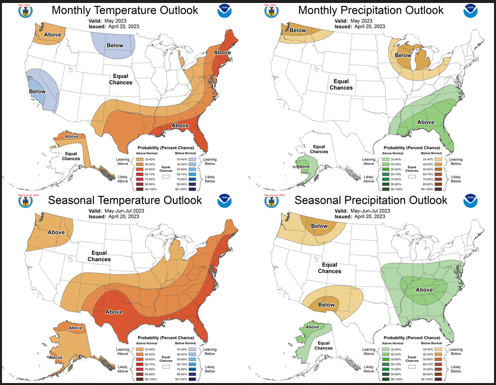
The top row is what is now called the Mid-Month Outlook for May which will be updated at the end of April. There is a temperature map and a precipitation map. The second row is a three-month outlook that includes May. I think the outlook maps are self-explanatory. What is important to remember is that they show deviations from the current definition of normal which is the period 1991 through 2020. So this is not a forecast of the absolute value of temperature or precipitation but the change from what is defined as normal or to use the technical term “climatology”.
| Notice that the May and three-month outlooks are fairly similar. But they are different in important ways so there is a predicted difference as the three-month period evolves. |
| For both temperature and precipitation, if you assume the colors in the maps are assigned correctly, it is a simple algebra equation to solve the month two/three anomaly probability for a given location = (3XThree-Month Probability – Month One Probability)/2*. So you can derive the month two/three outlook this way. You can do that calculation easily for where you live or for the entire map. |
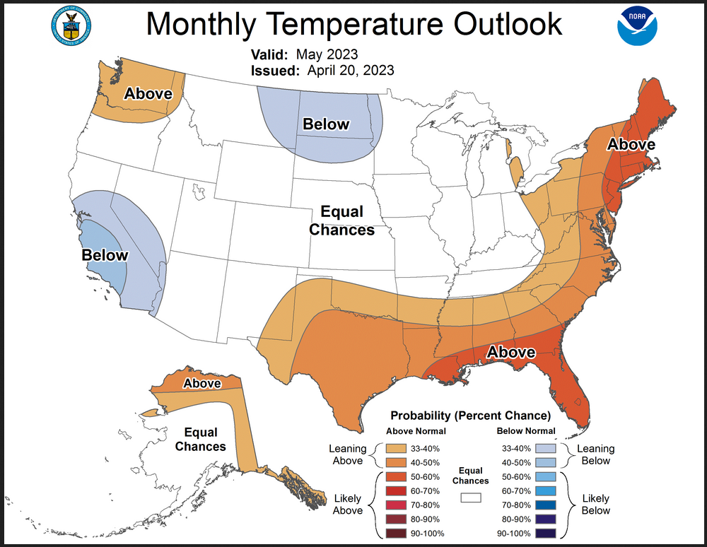
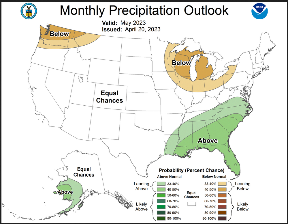
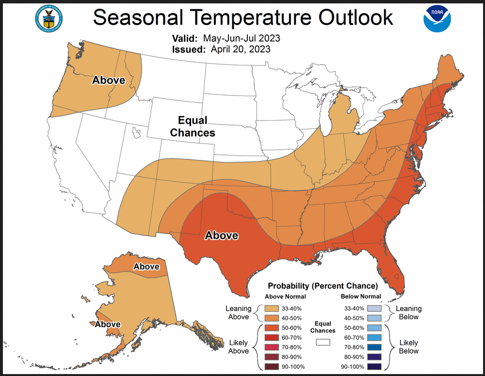
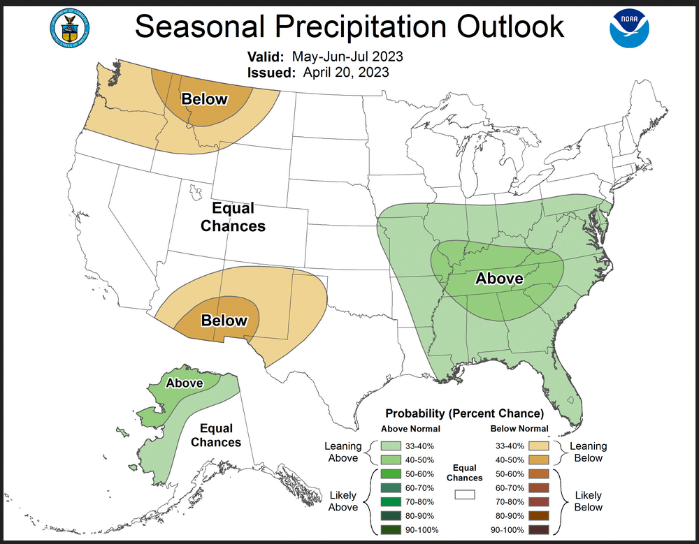
Here are larger versions of the Temperature and Precipitation outlook maps for the single month of May
The maps are pretty clear in terms of the outlook.
And here are large versions of the three-month MJJ 2023 Outlook
First temperature followed by precipitation.
The maps are larger versions of what was shown in the first graphic that had smaller versions of all four of these maps.
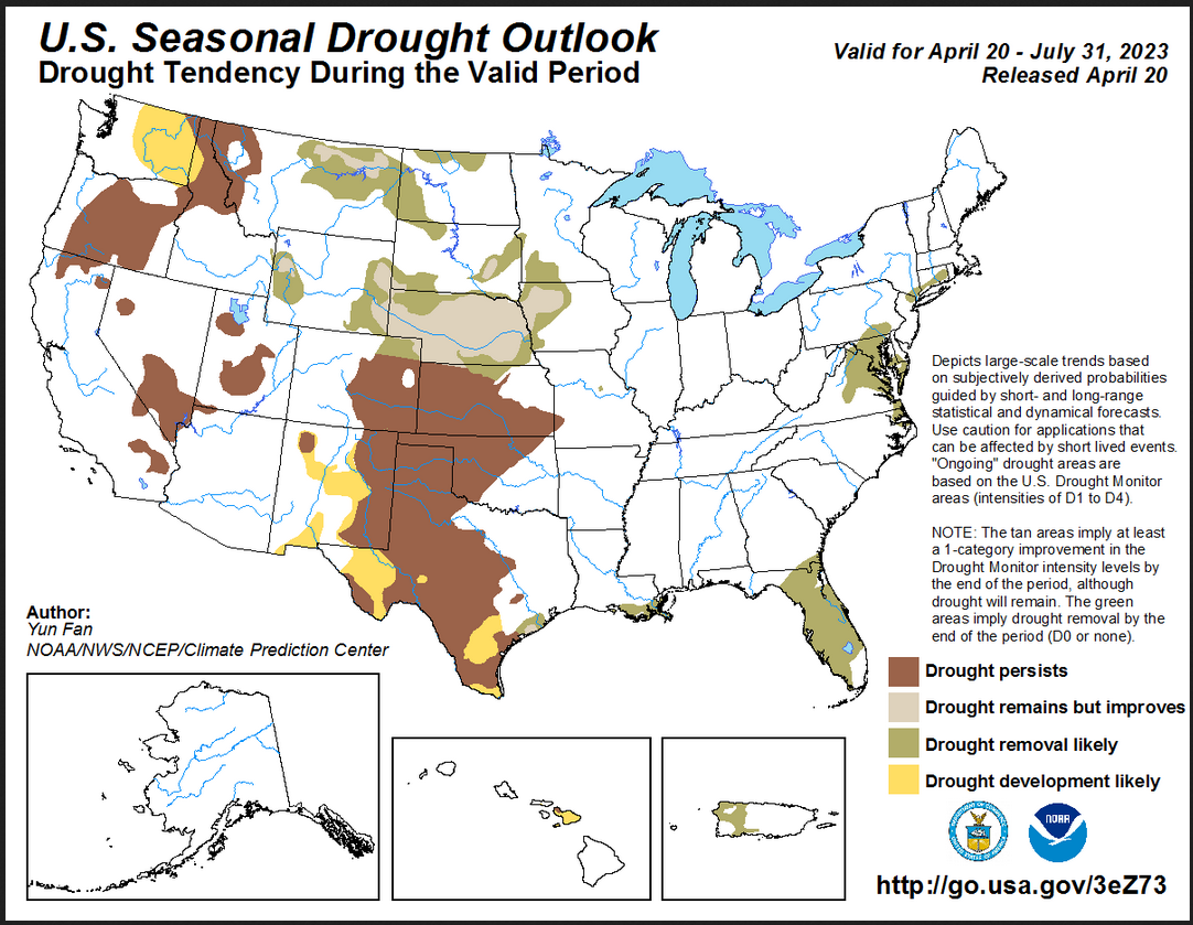
Drought Outlook
| The yellow is the bad news. And there is some of that. But the area with drought improvement is larger. There are some dry areas predicted but the initial conditions is limiting where the drought is expected to get worse. |
Short CPC Drought Discussion
Latest Seasonal Assessment – Based on the U.S. Drought Monitor, drought coverage across the contiguous U.S. (CONUS) peaked at 62.95 percent during late October 2022. Since that time, drought coverage and intensity have steadily decreased across much of the West, northern Great Plains, Midwest, Tennessee and Ohio Valleys. The coverage of severe (D2) to exceptional (D4) drought is near to its lowest since July 2020. Given that the May-June-July (MJJ) outlooks favor below-normal precipitation over the northwestern CONUS and above-normal temperatures, persistence is forecast for the existing drought areas with development likely in much of eastern Washington state. Due to lack of wet signals in the forecasts, drought persistence is likely for the remainder of the west with development likely for parts of New Mexico where below-normal precipitation and above-normal temperatures are forecast. An increasingly wet climatology during MJJ and a favorable time of year for soil moisture recharge favors broad-scale removal or improvement for the northern to central Plains and Midwest. Broad-scale persistence is the most likely outcome for a majority of the ongoing entrenched drought across most of the southern Great Plains due to lack of wet signals and above-normal temperatures in the forecasts with potential development for parts of western and southern Texas. Improvement or removal is forecast along parts of the Texas and Louisiana Gulf Coast due to heavy precipitation forecast during the next two weeks. Removal is the most likely outcome for the Southeast due to all CPC forecasts, from the extended range forecasts to monthly and MJJ outlooks all calling for above-normal precipitation for the region and the increasingly wet climatology with sea breeze convection during June and July. Removal is likely for the Delmarva and persistence is likely for the existing drought over the coastal areas in southern New England. Alaska is likely to remain drought-free through the end of July. Drought persistence is favored for Hawaii Islands and removal is expected for Puerto Rico.
Looking out Four Seasons.
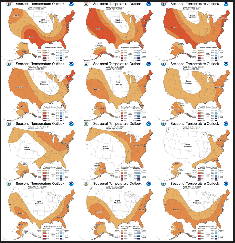
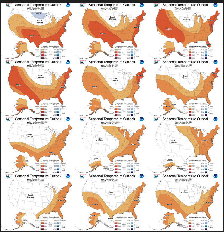
Twelve Temperature Maps. These are overlapping three-month maps (larger versions of these and other maps can be accessed HERE)
Notice that this presentation starts with June/July/August 2023 (JJA since MJJ is considered the near-term and is covered earlier in the presentation. The changes over time are generally discussed in the discussion but you can see the changes easier in the maps.
Comparing the new outlook with the prior Outlook,
The 12 temperature maps issued last month.
I have been showing the current set of outlooks with the prior set side by side. But I think the images are too small for most to be able to work with. I do the analysis so you do not need to but if you choose to do so the best way is to print out both maps. If you have a color printer that is great but not needed. What I do is number the images from last month 1 – 12 starting with “1” and going left to right and then dropping down one row. Then for the new set of images, I number them 2 – 13. That is because one image from last month in the upper left is now discarded and a new image on the lower right is added. Once you get used to it, it is not difficult. In theory, the changes are discussed in the NOAA discussion but I usually find more changes. It is not necessarily important. I try to identify the changes but believe it would make this article overly long to enumerate them. The information is here for anyone who wishes to examine the changes. I comment on some of the changes from the prior report by NOAA and general changes in the pattern.
| There are some changes between the new forecast and the prior forecast but I did not conclude that they were important to identify. The confidence that there will be an El Nino is now higher and the implications of that are well discussed in the NOAA discussion. |
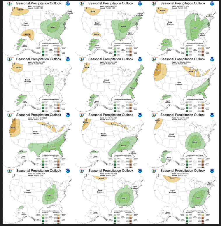
Now the Twelve New Precipitation Maps
Similar to Temperature in terms of the organization of the twelve overlapping three-month outlooks.
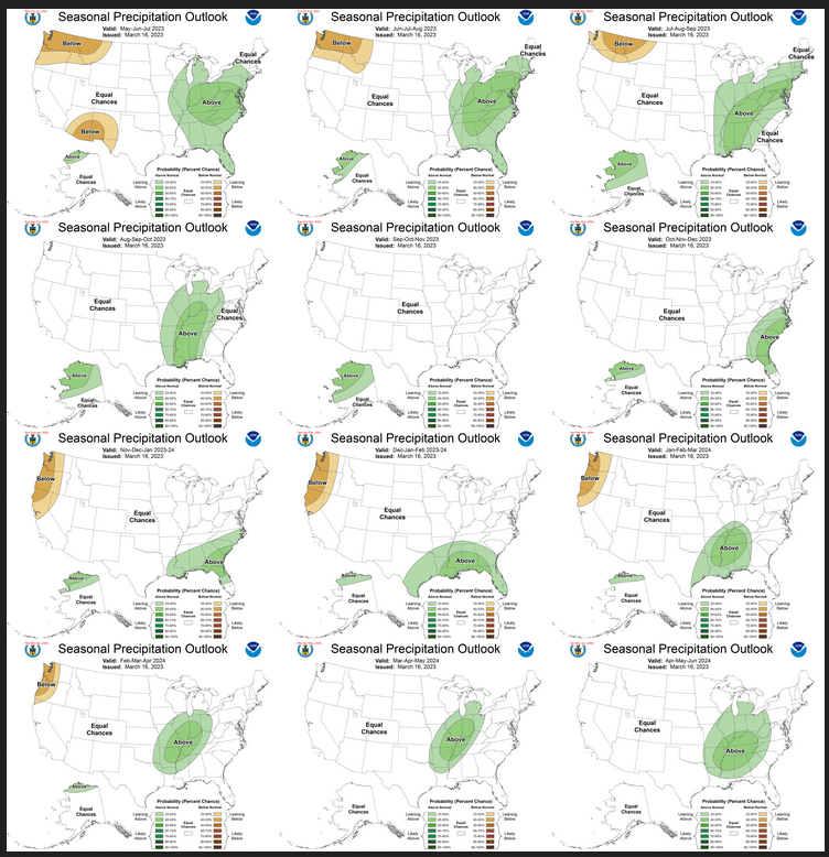
Comparing the new outlook with the prior Outlook,
The maps that were released last month.
A good approach for doing this comparison is provided with the temperature discussion.
| There are some changes between the new forecast and the prior forecast but I did not conclude that they were important to identify other than the impacts on the Southwest Monsoon. The confidence that there will be an El Nino is now higher and the implications of that are well discussed in the NOAA discussion. |
NOAA Discussion
Maps tell a story but to really understand what is going you need to read the discussion. I combine the 30-day discussion with the long-term discussion and rearrange it a bit and add a few additional titles (where they are not all caps the titles are my additions). Readers may also wish to take a look at the article we published last week on the NOAA ENSO forecast. That can be accessed here.
I will use bold type to highlight some things that are especially important. My comments, if any, are enclosed in brackets [ ].
CURRENT ATMOSPHERIC AND OCEANIC CONDITIONS
The coupled oceanic and atmospheric observations reflect ENSO-neutral conditions. During March 2023, above-average sea surface temperatures (SSTs) became more prominent in the western and far eastern equatorial Pacific Ocean. The latest weekly Niño-3.4 index value was +0.1°C, but the Niño1+2 index value was +2.7°C, indicating significant warming along the South American coast. Area-averaged subsurface temperatures also increased over the past month, reflecting the dominance of above-average subsurface temperatures across the equatorial Pacific Ocean. For the monthly average, upper-level and low-level winds were near normal across most of the equatorial Pacific Ocean. However, low-level westerly wind anomalies were evident in the first half of March associated with sub-seasonal activity. Suppressed convection was evident over the central tropical Pacific and over parts of Indonesia. While the warming near coastal South America was striking, the basin-wide coupled ocean-atmosphere system was consistent with ENSO-neutral.
An active Madden Julian Oscillation (MJO) remains apparent, with the enhanced convective phase now crossing the Pacific. The MJO has disrupted the trade wind regime across the Pacific, while downwelling oceanic Kelvin wave activity has helped transport anomalously warm waters across the entire basin. Other modes appear to be disrupting the intraseasonal signal, including Kelvin wave activity crossing the Western Hemisphere ahead of the MJO enhanced convective envelope, Rossby wave activity over the Maritime Continent, and a stubborn suppressed signal near the Date Line. Dynamical model forecasts from the Global Ensemble Forecast System (GEFS) and European Centre for Medium-Range Weather Forecasts (ECMWF) models depict continued MJO activity through the next week, with some indication of a disruption of the signal in Week 2 given interference from Rossby and Kelvin wave activity. Some ensemble members, particularly from GEFS, favor continuation of the MJO into early May though the phase speed and amplitude of the MJO is uncertain at this time.
PROGNOSTIC DISCUSSION OF SST FORECASTS
The most recent Institute Research Institute for Climate and Society (IRI) plume favors a transition to El Niño, beginning June-August 2023 and persisting into the Winter. While the lower accuracy of forecasts during the spring can result in surprises, the recent oceanic Kelvin wave plus recurring westerly wind anomalies are anticipated to further warm the tropical Pacific Ocean. The coastal warming in the eastern Pacific may foreshadow changes across the Pacific basin. Therefore, an El Niño Watch has been issued, and the range of possibilities toward the end of the year includes a strong El Niño (4 in 10 chance of Niño-3.4 ≥ 1.5°C) to no El Niño (1 in 10 chance). In summary, ENSO-neutral conditions are expected to continue through the Northern Hemisphere spring, followed by a 62% chance of El Niño developing during May-July 2023.
30-DAY OUTLOOK DISCUSSION FOR MAY 2023
The May 2023 Temperature and Precipitation Outlooks include the latest statistical and dynamical model guidance, impacts from decadal trends , local sea surface temperature (SST) anomalies, surface moisture conditions, and potential influence from the Madden Julian Oscillation (MJO). MJO is currently active in recent observations, and Realtime Multivariate MJO (RMM) index forecasts from the Global Ensemble Forecast System (GEFS) and European Centre for Medium-Range Weather Forecasts (ECMWF) models depict continued MJO activity through the next week, with some indication of a disruption of the signal in Week 2 given interference from Rossby and Kelvin wave activity. Some ensemble members, particularly from GEFS, favor continuation of the MJO into early May though the phase speed and amplitude of the MJO is uncertain at this time. MJO played a marginal role in this forecast given its uncertain evolution, and will be considered more heavily for the monthly update. El Niño Southern Oscillation (ENSO) conditions are currently neutral, but near to above average sea surface temperature (SST) anomalies have expanded across the equatorial Pacific in the past few weeks with SST anomalies in the eastern Pacific (NINO1+2) reaching 2.7 degrees Celsius above normal. Though warm SST anomalies have become more prominent in the eastern Pacific, transition to El Niño conditions has not yet occurred and teleconnections are not anticipated to impact the May forecast at this time. Dynamical model guidance from the North American Multi-Model Ensemble (NMME), Copernicus model suite (C3S), and the Climate Forecast System version 2 (CFSv2) were considered for the outlook as well as statistical models. Week 3-4 forecasts from CFSv2, ECMWF, and GEFSv12 for the early part of May were also considered.
With ENSO neutral conditions in the equatorial Pacific and an uncertain MJO evolution, as well as expected larger influence from daily weather patterns on the large-scale climate signal during the boreal spring, tools supporting the Temperature and Precipitation Outlooks are generally uncertain or have mixed results particularly for precipitation. As such, probabilities are moderated in the official Outlooks, and equal chances of above, median, or below normal temperature (precipitation) (EC) is indicated where tools disagree or signals are weak.
Temperature
The May 2023 Temperature Outlook depicts above normal temperature probabilities stretching from Texas along the east coast of the Contiguous United States (CONUS). NMME and C3S both favor above normal probabilities over eastern parts of the CONUS, and this tilt toward above normal probabilities is additionally supported by the Weeks 3-4 Outlook and tools which generally feature enhanced probabilities of above normal temperatures over the Gulf States and east coast in early parts of May. Probabilities are enhanced along parts of the coast and New England given anomalously warm coastal SSTs. 40 to 50 percent probabilities of above normal temperatures are indicated over Texas where soil moisture is anomalously dry. Great Lakes temperatures are above normal, and as such a slight tilt toward above normal temperatures is favored over the Lower Great Lakes where dynamical models also had agreement, however, much of the Upper Great Lakes and Ohio River Valley regions had conflicting signals amongst the tools. Moreover, uncertainty in the phase speed and amplitude of the potential MJO could lead to differing teleconnections over the eastern CONUS. As such, EC is indicated over the Upper Great Lakes and Ohio River Valley. Weak probabilities of above normal temperatures are indicated over parts of the Pacific Northwest where statistical guidance and recent CFSv2 solutions agree. Higher elevations where snow cover remains, including the Cas cades, may see pockets of below normal temperatures earlier in May. Snow cover is anomalously high over parts of eastern North Dakota and western Montana. Given forecasts for the remainder of April and beginning of May that tilt toward cooler temperatures which could delay snow melt, below normal temperature probabilities are indicated for parts of the north central CONUS. Below normal temperatures over this region are also supported by recent CFSv2 runs and below normal decadal temperature trends . Below normal temperature probabilities are also favored for parts of the west coast where there is good agreement among models, also supported by anomalously cold west coast SSTs.
Tools are somewhat inconsistent over Alaska, particularly the southern half of the state. Statistical tools depict above normal temperatures over AK, while C3S favors below normal temperatures over the southwestern coast where SST anomalies are below normal, and CFSv2 favors a transition to EC or below normal temperatures along the south coast. The area of highest agreement is for above normal temperatures over the North Slope, but anomalously high snow cover over the Brooks Range will likely lead to cooler temperatures and EC is indicated for the remainder of the state.
Precipitation
Disagreement among models and tools is relatively higher for precipitation, and as such probabilities are low and a large area of EC is favored in the May 2023 Precipitation Outlook. A tilt toward below normal precipitation is favored over the Pacific Northwest and parts of the Northern Rockies, consistent with forecasted warmer temperatures. Below normal precipitation is also indicated for parts of the Great Lakes where there was agreement among models. Models were also consistent on forecasting above normal precipitation over the Southeast, additionally supported by decadal trends . Soil moisture is anomalously high over parts of the Lower Mississippi Valley which supports expansion of the region of above normal precipitation probabilities. Tools and dynamical models forecast weak or inconsistent signals across much of Alaska, however, the area of highest consistency was over the southwestern coast where above normal precipitation probabilities are indicated.
SUMMARY OF THE OUTLOOK FOR NON-TECHNICAL USERS (Focus on May, June and July)
ENSO (El Niño Southern Oscillation) neutral conditions are present, as represented in current oceanic and atmospheric observations. ENSO-neutral conditions are expected to continue through the Northern Hemisphere spring, followed by a 62% chance of El Niño developing during May-July 2023, and a greater than 80% chance of El Niño by the Fall. Therefore, an El Niño Watch is now in effect.
Temperature
The May-June-July (MJJ) 2023 temperature outlook favors above normal temperatures for the eastern third of the Contiguous United States (CONUS), the Central and Southern Plains, the Pacific Northwest, parts of the Northern Rockies, parts of the Southwest, and all of the state of Alaska. The largest probabilities of above normal temperatures (greater than 50 percent) are forecast across the Southern High Plains and along the East and Gulf Coasts.
Precipitation
The MJJ 2023 precipitation outlook depicts enhanced probabilities of above normal precipitation amounts across the Ohio and Tennessee Valleys, the Southeast, the Mid-Atlantic Region, the Middle and Lower Mississippi Valley, and northern and western sections of Alaska. Below normal precipitation is more likely for the Southwest and the Southern High Plains, the Northern Rockies, the Pacific Northwest, and parts of the Northern High Plains. Equal chances (EC) are forecast for areas where probabilities for each category of seasonal mean temperatures and seasonal accumulated precipitation amounts are expected to be similar to climatological probabilities.
BASIS AND SUMMARY OF THE CURRENT LONG-LEAD OUTLOOKS
PROGNOSTIC TOOLS USED FOR U.S. TEMPERATURE AND PRECIPITATION OUTLOOKS
Dynamical model forecasts from the North American Multi-Model Ensemble (NMME) and Copernicus (C3S) ensemble systems and the Climate Forecast System Version 2 (CFSv2) are used extensively for the first six leads when they are available, as was the objective, historical skill weighted consolidation, that combines both dynamical and statistical forecast tools. The Calibration, Bridging and Merging (CBaM) tool anchored to the NMME forecasts and “bridged” to the Niño3.4 index is also significantly utilized. Current soil moisture content and snow pack are abnormally high for much of the western CONUS. Conversely, soils are abnormally dry across much of the southern and central High Plains. Farther to the north, Arctic Sea Ice extent is significantly lower than climatological averages. Additionally, the ENSO forecast depicts probabilities of El Niño that are significantly higher than climatological probabilities later this year. Current soil moisture conditions, snow pack, sea ice extent, extratropical sea surface temperatures (SSTs), and the anticipated El Niño signal played a role in the construction of these outlooks. At later leads, decadal trends in temperature and precipitation were increasingly relied upon in creating the seasonal outlooks.
PROGNOSTIC DISCUSSION OF OUTLOOKS – MJJ 2023 TO MJJ 2024
TEMPERATURE
The MJJ 2023 temperature outlook favors above normal temperatures for the eastern third of the CONUS, the Central and Southern Plains, the Pacific Northwest, parts of the Northern Rockies, parts of the Southwest, and all of the state of Alaska. A significant reduction in above normal temperature probabilities are evident relative to last month’s outlook across much of the West due to above normal snowpack and soil moisture conditions. Conversely, relatively high probabilities of above normal temperatures (greater than 50 percent) are forecast across the Southern High Plains as soil moisture conditions are abnormally dry. Elevated SSTs along with recent trends leads to likely above normal temperatures across the East and Gulf Coasts, where above normal temperature probabilities exceed 50 percent. There has been a noticeable cooling trend in the forecast consolidation across parts of the Mississippi and Tennessee valleys relative to last month. As a result, enhanced probabilities of above normal temperatures are relatively modest across these regions. Above normal temperatures are favored across Alaska, particularly for the North Slope, the southwestern coastal Mainland, the Alaska Peninsula, and the Aluetians due, in part, to below normal sea ice extent and above normal SSTs. Conversely, enhanced probabilities of above normal temperatures for interior Mainland Alaska are modest, as an abnormally high snowpack will likely delay the spring warmup across much of the state. Modestly enhanced probabilities of above normal temperatures are also indicated for the northwestern CONUS due to recent trends and support from the NMME and C3S multi-model ensembles.
For the summer seasons (June-July-August, JJA through July-August-September, JAS), the combined signals from dynamical model guidance, soil moisture, ENSO composites, and trend favor above normal temperatures for western, eastern, and southern CONUS as well as much of Mainland Alaska. The strongest warm signals are over much of the East and Gulf coasts and the Southern High Plains and expanding across the West as the summer progresses. Dynamical models , trend, solid moisture tools and ENSO composites are all in good agreement in these regions and probabilities of above normal temperatures exceed 50 percent for one or more of the core summer months across these regions. However, confidence is reduced over much of the West early in the summer as the current high snowpack and soil moisture may delay the summer warmup. Above normal temperatures are generally favored across most of Alaska with confidence increasing across southern parts of the state as the summer progresses. As we progress toward the fall and winter months (August-September-October, ASO 2023 through January-February-March, JFM 2024), El Niño is expected to become more of a factor and the pattern begins to increasingly reflect El Niño conditions during the cold months. As a result, enhanced probabilities of above normal temperatures indicated for the Southern CONUS late summer/early fall are reduced by the winter. Conversely, chances of above normal temperatures increase across the Northern Tier by the winter months. Warmer than normal conditions are generally favored for Alaska during the fall and winter months. However, probabilities are generally modest across the state due to wide variation of solutions derived from natural ENSO-based analogs . As we enter next spring (February-March-April, FMA through MJJ 2024) the outlook increasingly relies on recent trends and generally favors a transition to a warm pattern across the western, eastern, and southern CONUS and for much of Alaska.
PRECIPITATION
The MJJ 2023 precipitation outlook depicts enhanced probabilities of above normal precipitation amounts across the Ohio and Tennessee Valleys, the Southeast, the Mid-Atlantic Region, the Middle and Lower Mississippi Valley, and northern and western sections of Alaska. Below normal precipitation is more likely for the Southwest and the Southern High Plains, the Northern Rockies, the Pacific Northwest, and parts of the Northern High Plains. The combination of elevated snowpack and high soil moisture across much of the West coupled with below normal SSTs currently observed in the Gulf of California and the Pacific off the west Coast of the Baja California Peninsula would favor a slower evolution of monsoonal circulation. Therefore, elevated chances of below normal precipitation are indicated for much of the Southwest. The area of increased chances of below normal precipitation also extends eastward to much of the Southern High Plains, where below normal soil moisture content is currently being observed. Conversely, the forecast consolidation supports elevated probabilities of above normal precipitation across much of the eastern CONUS. There has been a noticeable westward shift in the wet signal this month, resulting in an expansion of enhanced above normal precipitation probabilities westward across the Mississippi Valley and parts of the eastern Plains. This westward expansion would be consistent with a slower monsoonal circulation evolution, as the precipitation pattern across the Plains tends to be anticorrelated with the Southwest monsoon region this time of year. Above normal precipitation is also favored for northern and western Alaska, particularly for the North Slope, as lower than normal Sea Ice Extent may enhance precipitation chances. Conversely, below normal precipitation is favored for the northwestern CONUS, due to recent trends and ENSO based statistical guidance.
During the summer months (JJA through JAS), a perpetuation of below normal precipitation is favored for the Southwest during the core monsoon months. Conversely, the noticeable westward shift in the wet signal seen in the spring continues into the summer, with increasing chances of above normal precipitation extending from the eastern CONUS to eastern portions of the Central Plains. This westward shift in the wet signal depicted in the forecast consolidation also resulted in a reduction of above normal precipitation chances for the Southeast, particularly later in the summer. Statistical and dynamical model guidance generally favors increased probabilities of above normal precipitation for northern and western Alaska through the summer. Increased chances of below normal precipitation are generally indicated for the Northern Rockies into the Pacific Northwest, consistent with recent trends. As we enter the fall and winter months, the pattern begins to increasingly reflect an El Niño signature. Increased probabilities for above normal precipitation depicted across the Ohio and Mississippi Valleys during late summer and early fall transitions to the East and Gulf Coasts during the winter months, consistent with El Niño. Conversely, an increasingly dry signal is evident across the northwestern CONUS by the winter with probabilities of below normal precipitation exceeding 40 percent across the Pacific Northwest from November-December-January (NDJ) 2023-24 through JFM 2024. A tilt toward below normal precipitation is also indicated for the Great Lakes Region westward toward the Northern Plains during the cold months, consistent with El Niño. Above normal precipitation is generally favored for northern Alaska, and to a lesser degree, western Alaska during the fall and winter months. The strongest wet signal exists for the North Slope due to recent trends . As we enter next spring, the precipitation forecast increasingly relies on trends . Thus, increased chances of above normal precipitation are indicated for much of the Ohio, Tennessee, and Middle and Lower Mississippi Valleys as well as parts of the Southeast from FMA 2024 through MJJ 2024. Later in the spring and into the summer (FMA – MJJ 2024) trends become increasingly dry for the Northern Rockies and a tilt toward below normal precipitation is indicated. Confidence decreases for Alaska as we approach the later leads with only a slight tilt toward above normal precipitation indicated for the North Slope by MJJ 2024 and equal chances indicated across the entire state by April-May-June (AMJ) 2024.
Review of the ENSO Assumptions utilized by NOAA (CPC) in Preparing this Four-Season Outlook
It is useful to review the ENSO forecasts used by NOAA to produce this Four-Season Outlook. We reported on that last week and you can read that article by clicking HERE
The key information used by NOAA follows.
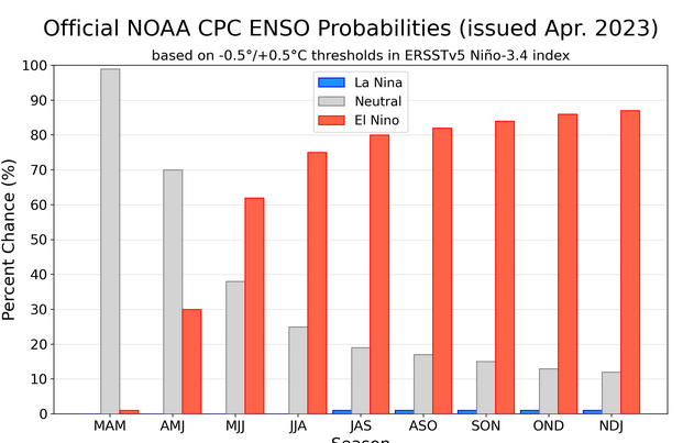
IRI CPC ENSO STATE Probability Distribution (IRI stands for the International Research Institute for Climate and Society)
Here are the new forecast probabilities. This information is released twice a month and the first release is based on a survey of Meteorologists, the second is based on model results. The probabilities are for three-month periods e.g. MAM stands for March/April/May. I am just showing the first release which is what we have and presumably what NOAA (actually their CPC Division) worked from.
| It is too early to be certain but it sure looks like we are headed into an El Nino. |
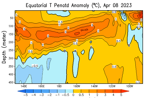
Tropical Subsurface Temperature Anomalies
| You can update this graphic by clicking HERE and scrolling down to “Mean and anomalous equatorial temperatures“. One has to differentiate between the surface and at depth. The surface still fits with ENSO Neutral but below the surface, there is a lot of anomalously warm water. That is why this looks like a sustainable El Nino. |
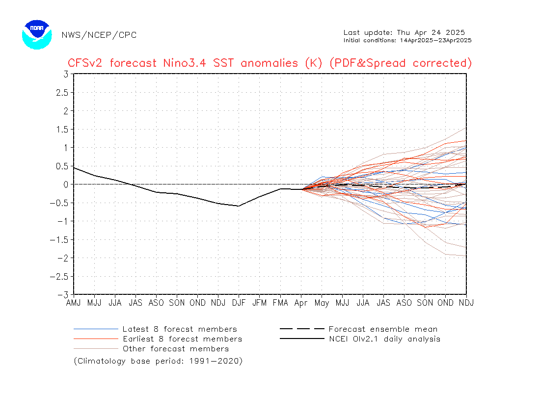
| The image will update if you click HERE. https://www.cpc.ncep.noaa.gov/products/people/wwang/cfsv2fcst/images3/nino34SeaadjPDFSPRDC.gif It is pretty bullish about a strong El Nino arriving pretty soon. |
Resources
The link for the drought outlook map and some discussions that come with the map can be found by clicking HERE.
| I hope you found this article useful and interesting. |
