Today Through the Fourth Friday (22 to 28 days) Weather Outlook for the U.S. and a Six-Day Forecast for the World: posted March 9, 2024

It is difficult to find a more comprehensive Weather Outlook anywhere else with the ability to get a local 10-day Forecast also.

This article focuses on what we are paying attention to in the next 48 to 72 hours. The article also includes weather maps for longer-term U.S. outlooks and a six-day World weather outlook which can be very useful for travelers.

First the NWS Short Range Forecast. The afternoon NWS text update can be found here but it is unlikely to have changed very much. The images in this article automatically update.

Short Range Forecast Discussion
NWS Weather Prediction Center College Park MD
Sat Mar 09 2024
Valid 12Z Sat Mar 09 2024 – 12Z Mon Mar 11 2024

…Heavy rain and some severe weather expected to move across the
Southeast today followed by heavy rain and strong winds across the
Mid-Atlantic and southern New England tonight into Sunday morning…

…Wet snow and strong winds across northern New England from tonight
through much of Sunday followed by lake-effect snows across the lower
Great Lakes into Monday morning…

…Frequent rounds of lower-elevation rain and mountain snow expected to
reach the Pacific Northwest through the next couple of days…

A complex interaction among a cold air mass dipping into the mid-section
of the country, an amplifying upper-level trough, moist air from the Gulf
of Mexico ingesting into the South, and a subtropical jet stream will
bring widespread increment weather through the eastern U.S. into Sunday.
The heaviest rainfall is expected to be found across the Southeast where
some of the thunderstorms could become severe. The Weather Prediction
Center has a Slight Risk of excessive rainfall forecast for the eastern
Carolinas for today. The low pressure center that forms and intensifies
along the southern front is forecast to track up the East Coast and reach
southern New England by early on Sunday. Areas from central Appalachians
into southern New England are expected to see a period of moderate to
occasionally heavy rain later today into early Sunday as the low pressure
center passes just to the southeast. Farther inland, colder air wrapping
around the intensifying storm will support wet snow across northern New
England during the same time period. This will be followed by lake-effect
snows across the lower Great Lakes into Monday morning when colder air
pours in behind the big low. Strong and gusty winds will expand and then
engulf the entire northeastern U.S. as the big low intensifies further and
begins to exit into the Canadian Maritimes by Monday morning.

In the wake of the storminess in the East, high pressure will take over
the entire central and southern U.S. with dry conditions persisting into
the new work week. The dry weather will extend into much of the western
U.S. as well. However, moisture associated with the next Pacific system
is forecast to reach the Pacific Northwest in a hurry today in the form of
lower-elevation rain and mountain snow for rather high elevations. More
systems arriving from the Pacific will result in frequent rounds of
precipitation persisting across the western portions of Washington,
Oregon, and down into northern California. The Cascades and higher
terrain of northern California will likely receive a couple more feet of
new snow through Monday.

Temperatures will generally be cooler than normal across the South but
above normal across the North. The East will be milder than normal today
ahead of the intensifying low pressure system before colder air surges
into the region on Sunday. Temperatures across the West will average near
normal.

To get your local forecast plus active alerts and warnings click HERE and enter your city, state or zip code.

Above is a 72 hour animation of the forecast. Learn about wave patterns HERE.

Then, looking at the world and of course, the U.S. shows here also. Today we are looking at precipitation.

Please click on “Read More” below to access the full Daily Report issued today.

Today Through the Fourth Friday (22 to 28 days) Weather Outlook for the U.S. and a Six-Day Forecast for the World: posted March 8, 2024

It is difficult to find a more comprehensive Weather Outlook anywhere else with the ability to get a local 10-day Forecast also.

This article focuses on what we are paying attention to in the next 48 to 72 hours. The article also includes weather maps for longer-term U.S. outlooks and a six-day World weather outlook which can be very useful for travelers.

First the NWS Short Range Forecast. The afternoon NWS text update can be found here but it is unlikely to have changed very much. The images in this article automatically update.

Short Range Forecast Discussion
NWS Weather Prediction Center College Park MD
300 AM EST Fri Mar 08 2024

Valid 12Z Fri Mar 08 2024 – 12Z Sun Mar 10 2024

…Snow gradually tapering off over the central High Plains as well as
central/southern Rockies…

…Threat of flash flooding and severe weather expected to sweep across
the Deep South to the Southeast through the next couple of days…

…An intensifying low pressure system will bring locally heavy rain and
strong winds from the Ohio Valley to New England late Saturday into
Sunday…

…Wet snow expected across the Great Lakes to northern New England late
Saturday to Sunday as next round of rain and mountain snow reaches the
Pacific Northwest…

Upper-level moisture arriving from the eastern Pacific in association with
a subtropical jet stream will interact with a cold air mass dipping into
the mid-section of the country through the next couple of days. This
interaction will result in active to locally severe weather to move from
west to east across many areas of the eastern half of the country through
Sunday morning. In addition, lower-level moisture from the Gulf of Mexico
will be ingested into the system. These complex interactions will result
in an axis of heavy rain and possibly severe weather to blossom later
today across the lower Mississippi Valley, spreading through the Deep
South Friday night, and then through the Southeast on Saturday.
Meanwhile, a low-level disturbance that has been sustaining locally heavy
snow over the central High Plains is forecast to weaken and allow the snow
there, as well as the snow over the central to southern Rockies, to
gradually taper off today into this evening. By Saturday, a low pressure
center is forecast to consolidate over the Ohio Valley when the system
intensifies more rapidly and tracks northeastward into the lower Great
Lakes Saturday night. Locally heavy rain and increasingly strong and
gusty winds are expected to develop from the Ohio Valley to New England
late Saturday into Sunday. Colder air wrapping around the low pressure
center is expected to change the rain to wet snow from across the Great
Lakes to portions of northern New England especially for the higher
elevations.

Much of the Great Plains will dry out on Saturday behind the low pressure
system as a high pressure system takes over. The dry weather will extend
into much of the western U.S. However, moisture associated with the next
Pacific system is scheduled to reach the Olympic Peninsula later today
with rain for the lower elevations and snow for rather high elevations.
The rain and mountain snow will expand southward across Oregon and into
northern California on Saturday into Saturday night. The Cascades will
see snow picking up intensity on Saturday as the next batch of moisture
getting ready to reach the coastline of the Pacific Northwest by early on
Sunday.

To get your local forecast plus active alerts and warnings click HERE and enter your city, state or zip code.

Above is a 72 hour animation of the forecast. Learn about wave patterns HERE.

Then, looking at the world and of course, the U.S. shows here also. Today we are looking at precipitation.

Please click on “Read More” below to access the full Daily Report issued today.

Today Through the Fourth Friday (22 to 28 days) Weather Outlook for the U.S. and a Six-Day Forecast for the World: posted March 7, 2024

It is difficult to find a more comprehensive Weather Outlook anywhere else with the ability to get a local 10-day Forecast also.

This article focuses on what we are paying attention to in the next 48 to 72 hours. The article also includes weather maps for longer-term U.S. outlooks and a six-day World weather outlook which can be very useful for travelers.

First the NWS Short Range Forecast. The afternoon NWS text update can be found here but it is unlikely to have changed very much. The images in this article automatically update.

Short Range Forecast Discussion
NWS Weather Prediction Center College Park MD
Thu Mar 07 2024
Valid 12Z Thu Mar 07 2024 – 12Z Sat Mar 09 2024

…Storm system to bring the threat of flash flooding and severe weather
to the Southern Plains Thursday, spreading eastward into the Lower
Mississippi Valley and Southeast Friday…

…Areas of moderate to heavy snow expected for the Central Rockies/High
Plains Thursday…

…Another Critical Risk of Fire Weather Thursday for the Southern High
Plains…

…High temperatures remain above average and Spring-like for the eastern
U.S. with below average temperatures in the West…

A complex weather system evolving over the central U.S. will bring showers
and thunderstorms with the threat of severe weather and flash flooding to
the Southern Plains/Southeast, a risk of wildfires in the High Plains, and
some areas of heavy snow over the Rockies/Central High Plains over the
next couple of days. Upper-level troughing approaching from the west will
help to deepen/organize a low pressure/frontal system over the Southern
Plains, further reinforced by a Pacific system moving in from the West.
Southerly moist Gulf return flow ahead of a sharpening dryline will bring
increasing shower and thunderstorm chances to the Southern Plains
beginning as early as Thursday morning. Increasing deep-layer shear with
the approach of the upper-level trough as well as sufficient CAPE will
bring the threat for a few severe thunderstorms, and the Storm Prediction
Center has highlighted central Texas and western Oklahoma/south-central
Kansas with Slight Risks of Severe Weather (level 2/5) for some instances
of large hail along with damaging winds and an isolated tornado. In
addition, the increasing moisture will lead to some heavier downpours, and
the threat for a couple rounds of storms evolving downstream over north
Texas Thursday evening has prompted a Slight Risk of Excessive Rainfall
(level 2/4) for some scattered instances of flash flooding, particularly
for urban areas in the DFW metroplex. Very dry conditions will exist west
of the dryline over the Southern High Plains, which when combined with
warm temperatures and gusty winds has prompted a Critical Risk of Fire
Weather (level 2/3) form the Storm Prediction Center. To the northwest, a
secondary frontal system pushing southward will bring much colder air into
the Central Rockies/High Plains. Areas of moderate to heavy snow are
expected to continue through the day Thursday for portions of the Central
Rockies, particularly along the Front Range in Colorado. In addition,
confidence has increased in a round of snow bands moving through portions
of northeastern Colorado into western Nebraska bringing heavy snow rates
of 1-2″+ per hour and several inches of accumulating snow, with Winter
Storm Warnings now in effect. The snow should come to an end for the High
Plains into Friday morning, with chances in the mountains shifting
southward into the Southern Rockies.

The system will continue eastward Friday, with an expanding area of shower
and thunderstorms spreading into the Midwest, Lower Mississippi Valley,
and Southeast. A reinforcing influx of more anomalous moisture flowing
northward with a warm front from the Gulf will bring a higher threat for
more widespread heavy downpours compared to Thursday, with the expectation
that clusters of storms will bring repeated rounds of rainfall along the
frontal boundary into Friday night. A Moderate Risk of Excessive Rainfall
(level 3/4) has been introduced from east-central Alabama into northern
Georgia where wet antecedent conditions from the night before will further
help increase the threat for some scattered to numerous instances of flash
flooding, particularly for urban areas in the greater Atlanta region. A
broader Slight Risk is in place from the Lower Mississippi Valley eastward
through the Southern Appalachians. Another round of severe weather is also
expected, with a Slight Risk of Severe Weather stretching from eastern
Texas/southeastern Oklahoma through the Lower Mississippi Valley and
towards the central Gulf Coast. Large hail, damaging winds, and a few
tornadoes are all possible.

Elsewhere, the noted Pacific system eventually reaching the Plains will
first move eastward from California into the Great Basin/Southwest on
Thursday, with some light to moderate rain/snow showers for the Great
Basin and a few thunderstorms in the deserts of the Southwest. Some light
to moderate showers will taper off through the day Thursday in southern
New England as a frontal system departs the region, with the potential a
bit of snow may mix in. Some additional light snowfall accumulations will
be possible further north into Maine. Showers and thunderstorms will also
continue in South Florida Thursday ahead of a cold front. Finally, an
approaching Pacific system will bring increasing precipitation chances to
the Pacific Northwest later Thursday and into Friday morning.

Temperature wise, highs will remain above average for much of the eastern
U.S. ahead of the frontal systems approaching from the west over the
Plains. Highs will range from the 40s and 50s in the Upper Midwest east
through the Great Lakes and New England; the 50s and 60s from the Middle
Mississippi Valley east through the Ohio Valley and into the Mid-Atlantic;
and the 60s and 70s from the Lower Mississippi Valley into the Southeast.
Portions of the Central/Southern Plains will be above average Thursday,
with highs in the 50s and 60s in the Central Plains and 70s and 80s in the
Southern Plains. Cold fronts passing through with the central U.S. system
will bring some much cooler temperatures Friday, with highs dropping to
the 40s and 50s for western portions of the Plains. The Northern Plains
will recover Friday following a chilly day Thursday, with highs in the 20s
and low 30s rising into the upper 30s and 40s. Temperatures will generally
remain below average in the West, with 30s and 40s for the Pacific
Northwest and Great Basin, 50s and 60s for California, and 60s and 70s
into the Southwest.

To get your local forecast plus active alerts and warnings click HERE and enter your city, state or zip code.

Above is a 72 hour animation of the forecast. Learn about wave patterns HERE.

Then, looking at the world and of course, the U.S. shows here also. Today we are looking at precipitation.

Please click on “Read More” below to access the full Daily Report issued today.

Today Through the Fourth Friday (22 to 28 days) Weather Outlook for the U.S. and a Six-Day Forecast for the World: posted March 6, 2024

It is difficult to find a more comprehensive Weather Outlook anywhere else with the ability to get a local 10-day Forecast also.

This article focuses on what we are paying attention to in the next 48 to 72 hours. The article also includes weather maps for longer-term U.S. outlooks and a six-day World weather outlook which can be very useful for travelers.

First the NWS Short Range Forecast. The afternoon NWS text update can be found here but it is unlikely to have changed very much. The images in this article automatically update.

Short Range Forecast Discussion
NWS Weather Prediction Center College Park MD
Wed Mar 06 2024
Valid 12Z Wed Mar 06 2024 – 12Z Fri Mar 08 2024

…Wet Wednesday in store from the Ohio/Tennessee Valleys to the East
Coast, with locally heavy rainfall and the risk of scattered flash
flooding along the I-95 urban corridor…

…Showers and thunderstorms expected along the California coast
Wednesday…

…Strengthening storm system in the Plains to bring showers and
thunderstorms with the threat of severe weather Thursday…

…Above average temperatures persist for much of the central/eastern U.S.
as conditions remain below average in the West…

Wet weather will continue for portions of the eastern U.S. from the
Ohio/Tennessee Valleys eastward to the East Coast in a complex pattern.
Ongoing showers will continue along a slow moving cold front stretching
from the Interior Northeast southwestward through the Ohio Valley,
expected to make little eastward progress today and eventually stalling
along the Appalachians. Meanwhile, a combination of upper-level energies
and associated waves of low pressure along a quasi-stationary frontal
boundary draped along the East Coast southwestward through the Southeast
will spread showers and thunderstorms northeastward through the day
Wednesday from the Southeast into the Mid-Atlantic and New England. A
couple axis of locally heavier rainfall are forecast to occur to the east
of the low pressure waves where enhanced very moist, onshore flow from the
Atlantic will exist. Slight Risks of Excessive Rainfall (level 2/4) are
outlooked for the North Carolina Outer Banks and for the coastal
Mid-Atlantic into southern New England, from New Jersey northeastward to
far southwest Maine. Areal average rainfall totals of 1-2″, locally 3″,
may lead to some scattered instances of flash flooding, especially for
urban areas along the I-95 corridor. In addition, some locally heavy
downpours will be possible in South Florida ahead of the trailing frontal
boundary. The front/low pressure waves will begin to push away from the
coast overnight Wednesday into Thursday morning, with rain chances
lingering longest into the day Thursday in New England. Some wintry
precipitation will mix in for portions of New England as colder air
spreads southward behind the departing system, and some light snow
accumulations will be possible into Maine.

In the West, an upper-level low/Pacific frontal system will move southward
along the California coast and eventually inland, bringing showers and
storms to the area Wednesday. Some locally heavy rainfall will be possible
through southern California, which may lead to some isolated flash
flooding concerns given the very sensitive conditions still in place over
the area after recent heavy rainfall events. Some snow showers will linger
through portions of the higher elevations of the southern Pacific
Northwest/northern California and northern Great Basin, but will come to
an end as moisture flow follows the Pacific system southward. A light
wintry mix for the central Great Basin and showers for the Desert
Southwest will follow the system as it progresses eastward on Thursday.

Precipitation chances will also increase for the center of the country as
a couple different systems pass through the region. To the north, an
upper-level wave will help to deepen/organize a low pressure system over
the Northern Plains, forecast to lift northeastward through the Upper
Midwest and into Canada Wednesday-Thursday. Some light showers will be
possible ahead of the system, but more precipitation is expected to follow
in the colder air on the backside of the system track along the Canadian
border. Some light to moderate snow accumulations are expected through
Thursday morning from northern North Dakota into northwestern Minnesota.
Further south, the upper-level trough over the West will approach the
Central/Southern Plains from the west, helping to induce lee cyclogenesis
along the Rockies and organize/strengthen a frontal system over the Plains
by Thursday. A broad area of showers and thunderstorms is expected in the
warm sector ahead of the system over the Central/Southern Plains into the
Middle/Lower Mississippi Valley as moist Gulf return flow spreads
northward, especially into Thursday evening/night. Strengthening deep
layer shear as stronger winds arrive with the approach of the upper-level
trough may lead to some severe thunderstorms, with the Storm Prediction
Center highlighting western Oklahoma into northwest/central Texas in a
Slight Risk (level 2/5) for the threat of some large hail as well as
damaging winds and an isolated tornado. Some locally heavy downpours and
an isolated risk of flash flooding will exist more broadly across the
region as well. Finally, the system will bring some moderate higher
elevation/mountain snow to portions of the Central Rockies, with some
lighter snow mixing in for the Central High Plains.

A familiar pattern of above average temperatures for central/eastern
portions of the country and below average temperatures in the West looks
to continue for at least the next couple of days. Highs for many locations
will be upwards of 10-20 degrees above average from the Plains to the East
Coast. Forecast highs generally range from the 40s and 50s from the Upper
Midwest east through the Great Lakes and New England; the 50s and 60s from
the Central Plains east through the Middle Mississippi/Ohio Valleys into
the Mid-Atlantic; and the 60s and 70s from the Southern Plains east
through the Lower Mississippi Valley into the Southeast and Florida. A
pocket of much colder temperatures in the 20s and 30s behind a cold front
in the far Northern Plains will begin to spread southward following the
front, with highs dropping into the 30s and 40s for portions of the
Northern/Central Plains Thursday after a warmer Wednesday. Forecast highs
in the West range from the 30s and 40s in the Pacific Northwest and Great
Basin, the 50s and 60s in California, and the 60s and 70s in the Desert
Southwest.

To get your local forecast plus active alerts and warnings click HERE and enter your city, state or zip code.

Above is a 72 hour animation of the forecast. Learn about wave patterns HERE.

Then, looking at the world and of course, the U.S. shows here also. Today we are looking at precipitation.

Please click on “Read More” below to access the full Daily Report issued today.

Today Through the Fourth Friday (22 to 28 days) Weather Outlook for the U.S. and a Six-Day Forecast for the World: posted March 5, 2024

It is difficult to find a more comprehensive Weather Outlook anywhere else with the ability to get a local 10-day Forecast also.

This article focuses on what we are paying attention to in the next 48 to 72 hours. The article also includes weather maps for longer-term U.S. outlooks and a six-day World weather outlook which can be very useful for travelers.

First the NWS Short Range Forecast. The afternoon NWS text update can be found here but it is unlikely to have changed very much. The images in this article automatically update.

Short Range Forecast Discussion
NWS Weather Prediction Center College Park MD
Tue Mar 05 2024
Valid 12Z Tue Mar 05 2024 – 12Z Thu Mar 07 2024

…A wet weather pattern for large areas to the east of the Mississippi
River…

…Heavy higher elevation snows continue for northern portions of the West
Tuesday with improving conditions by Wednesday…

…Much above average temperatures expected for much of the lower 48 to
the east of the Rockies over the next few days…

Widespread showers and thunderstorms bringing areas of moderate rainfall
continue this morning along a slow-moving cold front stretching from the
Great Lakes into the Middle and Lower Mississippi Valley. Storm chances
will shift into the Lower Great Lakes southwestward through the Ohio and
Tennessee Valleys through the day Tuesday as the front makes some eastward
progress. To the south, another frontal boundary along the Gulf Coast will
lift northward, bringing with it additional Gulf moisture and storm
chances into the Southeast. A wave of low pressure is expected to develop
along the boundary overnight Tuesday as the system shifts northeastward
into the Carolinas. More widespread moderate to locally heavy rainfall is
expected through the region with an isolated threat of flash flooding.
Meanwhile, a coastal low in the Mid-Atlantic will continue northward
bringing light to moderate showers from the Mid-Atlantic into New England
Tuesday. By Wednesday, the low pressure system over the Southeast will
begin to better organize and shift northeastward along the coast towards
the Mid-Atlantic/New England. The frontal system over the Great Lakes will
move eastward into the Northeast as well, helping to focus a renewed round
of heavier showers along a northeastward axis from the coastal
Mid-Atlantic through New England. A Slight Risk of Excessive Rainfall
(level 2/5) is in place for portions of southern New England where the
heaviest rainfall will overlap wet antecedent conditions and areas with
higher stream flows, which may result in some scattered instances of flash
flooding. Some wintry precipitation may mix in north of the cold front
over northern New England overnight Wednesday.

One more day of heavy higher elevation/mountain snows continues in the
West as an energetic jet stream sits over a quasi-stationary boundary and
an influx of Pacific moisture focused through northern California and the
southern Pacific Northwest into the northern Great Basin and Rockies.
Several more inches of snow are forecast in the regional mountain ranges
from the southern Cascades and northern Sierra east to the Tetons in
Wyoming. Colder air settling in with the front has brought snow levels
lower, bringing snow to interior lower elevation valley locations as well
from southern Oregon into western Idaho. Another Pacific storm system
dropping southward along the California Coast will help to shift the
influx of Pacific moisture southward by Wednesday, finally bringing
improving conditions as snowfall tapers off. Along the coast, some
locally heavy rainfall is expected Tuesday for northern California,
shifting southward with the system into southern California Wednesday.
Here, more sensitive conditions due to recent high profile rainfall events
may lead to an isolated but nonzero threat of flash flooding.

Elsewhere, an upper-level shortwave will help to deepen/better organize a
low pressure/frontal system lingering over the Northern Plains Wednesday,
leading to increasing precipitation chances. Some accumulating snowfall
looks possible along the Canadian border from northern North Dakota into
northern Minnesota by early Thursday. Further south, another organizing
frontal system will also bring increasing precipitation chances to the
Central and Southern Plains, with some showers and thunderstorms forecast
overnight Wednesday into early Thursday.

High temperatures will remain well above average by 10-20 degrees for the
lower 48 east of the Rockies through midweek. Some even greater anomalies
will be found in the Upper Ohio Valley/Lower Great Lakes Tuesday as
temperatures once again reach into the 70s, 25-35 degrees above average.
The cold front passing through by Wednesday will make temperatures
relatively cooler, but still above average, with highs in the upper 40s to
low 60s. The warmest temperatures will be found along the western Gulf
Coast into southern Texas with highs in the mid-80s to low 90s. A few
daily record-tying/breaking highs may be reached in both locations.
Otherwise, along the East Coast, forecast highs range between the 40s and
50s in New England, 50s and 60s in the Mid-Atlantic, 60s and 70s for the
Southeast, and 70s and 80s into Florida. For central portions of the
country, highs will be in the 40s and 50s for the Northern Plains/Upper
Midwest, 50s and 60s from the Central Plains through the Middle
Mississippi Valley and into the Lower Ohio Valley, and the 60s and 70s for
the Southern Plains and Lower Mississippi Valley. In the West, highs will
remain near or below average as mean troughing remains in place, with
temperatures ranging from the 20s and 30s for the Northern
Rockies/adjacent High Plains, 30s and 40s for the Great Basin and Pacific
Northwest, 50s and 60s for California, and 60s and 70s in the Southwest.

To get your local forecast plus active alerts and warnings click HERE and enter your city, state or zip code.

Above is a 72 hour animation of the forecast. Learn about wave patterns HERE.

Then, looking at the world and of course, the U.S. shows here also. Today we are looking at precipitation.

Please click on “Read More” below to access the full Daily Report issued today.

Today Through the Fourth Friday (22 to 28 days) Weather Outlook for the U.S. and a Six-Day Forecast for the World: posted March 4, 2024

It is difficult to find a more comprehensive Weather Outlook anywhere else with the ability to get a local 10-day Forecast also.

This article focuses on what we are paying attention to in the next 48 to 72 hours. The article also includes weather maps for longer-term U.S. outlooks and a six-day World weather outlook which can be very useful for travelers.

First the NWS Short Range Forecast. The afternoon NWS text update can be found here but it is unlikely to have changed very much. The images in this article automatically update.

Short Range Forecast Discussion
NWS Weather Prediction Center College Park MD
312 AM EST Mon Mar 04 2024
Valid 12Z Mon Mar 04 2024 – 12Z Wed Mar 06 2024

…Increasing shower and thunderstorm chances ahead of a slow moving cold
front through the Midwest, Mississippi Valley, and Southern Plains Monday,
and the Ohio Valley and Southeast Tuesday…

…Another coastal storm is forecast to bring a new round of rain to the
Mid-Atlantic Monday and New England Tuesday…

…Weather remains unsettled for northern portions of the West with
additional very heavy snowfall expected for higher mountain elevations…

…Much above average, Spring-like temperatures for much of the
central/eastern U.S.; wildfire threat remains elevated Monday for the
southern High Plains…

An almost quasi-stationary cold front extending southwestward from the
Great Lakes into the central/southern Plains will make slow progress
through the day Monday as ridging remains in place to the East. The
stagnant pattern will allow for additional moist return flow from the Gulf
today that will bring increasing shower and thunderstorm chances across
portions of the Midwest, Mississippi Valley, and Southern Plains compared
to Sunday, especially by Monday night. Some moderate to locally heavy
rainfall is possible along with an isolated threat for some severe
thunderstorms. Greater moisture closer to the central/western Gulf Coast
may lead to some more intense downpours from eastern Texas into the Lower
Mississippi Valley, with an isolated threat for flash flooding. A
relatively greater threat for a few more scattered instances of flash
flooding will exist over southeastern Louisiana where the combination of
repeated, back-building thunderstorms producing heavy downpours exists,
and a Slight Risk of Excessive Rainfall (level 2/5) has been introduced
for the area. The front will begin to make faster eastward progress by
Tuesday, bringing shower and thunderstorm chances into the Ohio/Tennessee
Valleys and Southeast. The chances for heavier rainfall will follow a
similar pattern for Monday, with more moderate rainfall for northern
locations and a greater chance for locally heavier rainfall and an
isolated instance or two of flash flooding from the Lower Mississippi
Valley into the Southeast. A Slight Risk of Excessive Rainfall will also
remain in effect for southeastern Louisiana as storms linger. To the east,
another coastal low pressure system is expected to deepen/better organize
along the Carolina coast Monday, bringing increasing shower chances
spreading northward into the Mid-Atlantic Monday and New England Tuesday.
Some moderate to locally heavy rainfall will be possible, particularly for
coastal locations of the Carolinas and Mid-Atlantic Monday.

An energetic upper-level jet stream and another low pressure/frontal
system approaching the West Coast will keep unsettled weather in place
over northern portions of the West the next couple of days. Additional
heavy higher elevation, mountain snowfall is expected over the southern
Cascades into the northern Sierra through Monday. Moisture spreading
inland will help enhance snowfall over portions of the northern Great
Basin Monday and into the northern Rockies Tuesday as well, particularly
for southern Idaho into western Wyoming. Snowfall will also linger into
the northern Cascades and central Rockies through Monday with generally
lighter amounts expected away from the influx of greater moisture. While
most of the accumulating snowfall should be limited to higher elevations,
portions of southern Oregon in particular will likely see at least a few
inches for inland lower elevation/valley locations as colder air pushes
southward and snow levels lower. Some moderate to locally heavy rainfall
is expected for coastal locations of the Pacific Northwest/northern
California, particularly near the California/Oregon border.

Widespread much above average, Spring-like high temperatures will persist
across the central/eastern U.S. to start the upcoming work week. The
greatest anomalies of 25-35 degrees will focus on the middle Mississippi
Valley northeastward into the Great Lakes and Ohio Valley Monday. Numerous
daily record-tying/breaking highs are possible as temperatures reach into
the 70s for most locations. The cold front pushing through the Midwest
will bring temperatures down into the 50s and 60s for the middle
Mississippi Valley into the upper Great Lakes Tuesday, though still above
average. Forecast highs range in the 70s and 80s for the southern Plains
Monday and Tuesday. Persistently dry conditions accompanied by lee
troughing and gusty winds will keep the threat for wildfires elevated
along portions of the southern High Plains according to the Storm
Prediction Center at least through Monday. Along the East Coast, highs are
forecast to range between the 40s and 50s for New England, 50s and 60s for
the Mid-Atlantic, and 70s to low 80s for the Southeast/Florida. In the
West, highs will remain cooler and below average, ranging from the 30s and
40s in the Pacific Northwest and much of the Interior West, 50s in
northern/central California, 60s in southern California, and 60s and 70s
into the Desert Southwest. The coldest spot in the country will be in the
northern Rockies/adjacent High Plains, where highs will be in the teens
and 20s.

To get your local forecast plus active alerts and warnings click HERE and enter your city, state or zip code.

Above is a 72 hour animation of the forecast. Learn about wave patterns HERE.

Then, looking at the world and of course, the U.S. shows here also. Today we are looking at precipitation.

Please click on “Read More” below to access the full Daily Report issued today.

Today Through the Fourth Friday (22 to 28 days) Weather Outlook for the U.S. and a Six-Day Forecast for the World: posted March 3, 2024

It is difficult to find a more comprehensive Weather Outlook anywhere else with the ability to get a local 10-day Forecast also.

This article focuses on what we are paying attention to in the next 48 to 72 hours. The article also includes weather maps for longer-term U.S. outlooks and a six-day World weather outlook which can be very useful for travelers.

First the NWS Short Range Forecast. The afternoon NWS text update can be found here but it is unlikely to have changed very much. The images in this article automatically update.

Short Range Forecast Discussion
NWS Weather Prediction Center College Park MD
315 AM EST Sun Mar 03 2024

Valid 12Z Sun Mar 03 2024 – 12Z Tue Mar 05 2024

…Winter storm in the West producing powerful blizzard in the Sierra
Nevada begins to wane through the day Sunday; more snow expected to begin
Monday…

…Accumulating snowfall near the Canadian border across Montana and North
Dakota with a wintry mix from North Dakota to northern Minnesota…

…Another coastal storm is forecast to bring additional rain along the
Mid-Atlantic coast later on Monday...

…Much above average, Spring-like temperatures shifting from the
Plains/Midwest into the Northeast as Critical Fire Weather threat persists
in the central/southern High Plains…

Conditions in the West which has been impacted by widespread heavy
mountain snows, gusty winds, and a powerful blizzard in the Sierra should
begin to improve by Sunday morning as a moisture plume form the Pacific
weakens and the track of upper-level energies shifts northward. Winds will
wane in intensity, though some additional heavy snowfall is expected
through the day, particularly for the southern Cascades/Sierra, Wasatch,
and central Rockies. However, additional upper-level energies approaching
the West Coast Monday look to quickly bring back increasing precipitation
chances, including heavy snowfall, to the southern Cascades/northern
Sierra, and potentially inland across the northern Great Basin. Timing and
the location of the heaviest amounts remains a bit uncertain at this time,
but another influx of moisture from the Pacific is expected. Rain showers
and thunderstorms will persist along the coast of the Pacific Northwest
and northern California as a surface trough lingers along the coast. Some
locally heavy rainfall may occur Monday as the next system moves in,
particularly along southern Oregon into northern California.

Upper-level energy shifting eastward away from the West is helping to
organize/deepen a low pressure/frontal system over the Northern Plains
this morning, which is forecast to track eastward towards the
Midwest/Great Lakes Monday. Moderate to locally heavy snowfall is expected
to the northwest of the surface low track as colder air spreads in from
the north, most likely along the Canadian border from eastern Montana into
western North Dakota. A wintry mix is expected to the east from eastern
North Dakota into northern Minnesota. The deepening low will also bring
some gusty winds, with the potential for blowing snow where snowfall does
occur. To the south and east across the Mississippi Valley/Midwest,
initially limited moisture will keep precipitation chances very low
through Monday morning despite the approaching frontal system. However,
southerly return flow from the Gulf will eventually begin to lead to
increasing shower and thunderstorm chances through the day Monday and
particularly Monday night. Deeper moisture over portions of the central
Gulf Coast into the Lower Mississippi Valley may result in some locally
heavy rainfall and an isolated instance or two of flash flooding. Some
severe thunderstorms producing large hail and damaging winds may also be
possible.

Showers will end Sunday morning in New England as a coastal storm departs
the region east into the Atlantic. A quasi-stationary frontal boundary
lingering southwestward along the coast of the Southeast and into Florida
will keep storm chances up there through the day Sunday. Then, on Monday,
another coastal low is expected to organize along the Carolinas and begin
to move northward, bringing additional shower chances into the
Mid-Atlantic through Tuesday morning, especially for coastal areas.

Widespread much above average, Spring-like high temperatures will persist
across the central/eastern U.S. Sunday and Monday. The greatest anomalies
of 25-35 degrees will stretch from the Lower/Middle Missouri Valley
northeastward into the Upper Great Lakes Sunday, shifting into the Ohio
Valley, Lower Great Lakes, and interior Northeast on Monday. Numerous
daily record-tying/breaking highs are possible as temperatures reach into
the 70s for most locations. Conditions will also be rather warm across the
central and southern Plains Sunday, with temperatures well into the 70s
and even low to mid-80s. Unfortunately, persistent lee troughing leading
to gusty winds and dry conditions will continue the threat for wildfires
along the central and southern High Plains, with a Critical Risk of Fire
Weather (level 2/3) outlined by the Storm Prediction Center. Along the
East Coast, highs are forecast to range between the 40s and 50s for New
England, 50s and 60s for the Mid-Atlantic, and 70s to low 80s for the
Southeast/Florida. In the West, highs will remain cooler and below
average, ranging from the 30s and 40s in the Pacific Northwest and much of
the Interior West, 50s in northern/central California, 60s in southern
California, and 60s and 70s into the Desert Southwest. The coldest spot in
the country will be in the Northern Rockies/adjacent High Plains, where
highs will be in the teens and 20s following a couple cold front passages.

To get your local forecast plus active alerts and warnings click HERE and enter your city, state or zip code.

Above is a 72 hour animation of the forecast. Learn about wave patterns HERE.

Then, looking at the world and of course, the U.S. shows here also. Today we are looking at precipitation.

Please click on “Read More” below to access the full Daily Report issued today.

Today Through the Fourth Friday (22 to 28 days) Weather Outlook for the U.S. and a Six-Day Forecast for the World: posted March 2, 2024

It is difficult to find a more comprehensive Weather Outlook anywhere else with the ability to get a local 10-day Forecast also.

This article focuses on what we are paying attention to in the next 48 to 72 hours. The article also includes weather maps for longer-term U.S. outlooks and a six-day World weather outlook which can be very useful for travelers.

First the NWS Short Range Forecast. The afternoon NWS text update can be found here but it is unlikely to have changed very much. The images in this article automatically update.

Short Range Forecast Discussion
NWS Weather Prediction Center College Park MD
300 AM EST Sat Mar 02 2024

Valid 12Z Sat Mar 02 2024 – 12Z Mon Mar 04 2024

…Winter storm continues this weekend in the West with heavy mountain
snow, widespread damaging winds, and powerful blizzard conditions in the
Sierra Nevada…

…Wintry mix for portions of the Northern Plains with some moderate to
locally heavy snow possible…

…A coastal storm will bring widespread rain up the East Coast through
Saturday…

…Much above average, Spring-like temperatures expanding from the
Plains/Midwest into the Northeast this weekend with Critical Fire Weather
threat for the central/southern High Plains…

A significant winter storm continues to impact much of the West, including
dangerous, blizzard conditions for the Sierra Nevada as an amplifying
upper-level trough forces its way into the western U.S. A multi-day influx
of moisture from the Pacific interacting with colder air pushing southward
from Canada is bringing heavy higher elevation, mountain snows across most
of the ranges of the Pacific Northwest, northern/central California, the
Great Basin, and the northern/central Rockies. There is at least a
moderate chance (40-60% probability) of an additional 12″+ of snowfall
through the end of the weekend. In addition, widespread wind-related
advisories and warnings remain in effect across much of the greater
western U.S. as wind gusts reach upwards of 55 mph, with gusts as high as
75 mph for higher elevations, leading to the risk of downed trees and
power lines. The combination of snow and high winds is most intense in the
Sierra Nevada, where heavy snow rates exceeding 3″ per hour and winds
gusting over 100 mph are causing significant blowing, drifting snow and
whiteout conditions, making travel impossible through the area. The most
intense snow and wind should begin to wind down through the day Sunday.
High temperatures will be below average this weekend with the colder
airmass moving in, with highs in the teens and 20s for the Northern
Rockies; 30s and 40s for the Pacific Northwest, northern California, the
Great Basin, and central Rockies; 50s for central California; and 60s for
southern California. Temperatures will be warmer into the Southwest with
highs in the 70s.

Falling heights as the amplifying trough begins to shift eastward over the
northern High Plains will help to deepen/organize a low pressure/frontal
system during the day Saturday. This system is forecast to track east into
the Upper Midwest/Great Lakes Sunday. Limited moisture ahead of the system
will keep precipitation chances rather low. However, in the colder air to
the north/northwest of the system, enough moisture will be in place for a
wintry mix of freezing rain and snow across portions of the Northern
Plains. Some moderate to locally heavy snowfall will be possible along the
Canadian border. Winds will likely also be rather breezy, with the
potential for some blowing snow. To the east, a low pressure/frontal
system lifting up the East Coast will continue to spread showers through
the Mid-Atlantic and into New England Saturday bringing moderate to
locally heavy rainfall, particularly for coastal locations. Some showers
and thunderstorms will remain possible along the frontal boundary
lingering southwestward along the coastal Southeast, Florida, and the
central Gulf Coast. Rain chances will come down overnight Saturday and
into early Sunday as the system pushes eastward away from the coast.

Widespread well above average, Spring-like temperatures are forecast to
continue for much of the Plains and Midwest this weekend. The greatest
anomalies will be centered over portions of the central/northern Plains
and Upper Midwest Saturday, spreading into the Great Lakes and Middle
Mississippi/Ohio Valleys on Sunday, where forecast highs reaching well
into the 60s and 70s are upwards of 25-35 degrees above average. Some
highs may tie/break local daily records. Further south, highs will be into
the 70s and 80s for the Southern Plains. Unfortunately, the combination of
these warm temperatures along with gusty winds and dry conditions have
resulted in another Critical Risk of Fire Weather (level 2/3) from the
Storm Prediction Center for portions of the central and southern High
Plains. The warming trend will spread into the Northeast on Sunday
following the departure of the coastal low, with highs warming into the
40s and 50s in New England and the 50s and 60s in the Mid-Atlantic. While
not quite as anomalous, highs across the Southeast into the 60s and 70s
are still running above early March averages.

To get your local forecast plus active alerts and warnings click HERE and enter your city, state or zip code.

Above is a 72 hour animation of the forecast. Learn about wave patterns HERE.

Then, looking at the world and of course, the U.S. shows here also. Today we are looking at precipitation.

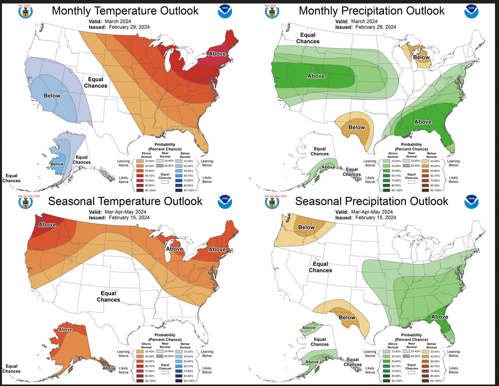
In case you missed it, this is the updated forecast for March and how it impacts the three-month Outlook.

Combination of the Updated Outlook for March and the Three-Month Outlook

The top row is the Updated Outlook for the new month. There is a temperature map and a precipitation map. The second row is a three-month outlook that includes the new month. I think the outlook maps are self-explanatory. What is important to remember is that they show deviations from the current definition of normal which is the period 1991 through 2020.  So this is not a forecast of the absolute value of temperature or precipitation but the change from what is defined as normal or to use the technical term climatology.

Please click on “Read More” below to access the full Daily Report issued today.

Today Through the Fourth Friday (22 to 28 days) Weather Outlook for the U.S. and a Six-Day Forecast for the World: posted March 1, 2024

It is difficult to find a more comprehensive Weather Outlook anywhere else with the ability to get a local 10-day Forecast also.

This article focuses on what we are paying attention to in the next 48 to 72 hours. The article also includes weather maps for longer-term U.S. outlooks and a six-day World weather outlook which can be very useful for travelers.

First the NWS Short Range Forecast. The afternoon NWS text update can be found here but it is unlikely to have changed very much. The images in this article automatically update.

Short Range Forecast Discussion
NWS Weather Prediction Center College Park MD
334 AM EST Fri Mar 01 2024

Valid 12Z Fri Mar 01 2024 – 12Z Sun Mar 03 2024

…Winter storm brings heavy higher elevation mountain snow, widespread
damaging winds, and cold temperatures to much of the West…

…Powerful blizzard in the Sierra Nevada through this weekend…

…Widespread showers and thunderstorms across portions of the Southeast
and Mid-Atlantic Friday…

…Much above average, Spring-like temperatures for the Plains and Midwest
once again heading into the weekend; Critical Fire Weather threat for the
central/southern High Plains Saturday...

A significant winter storm will impact much of the West heading into the
weekend, including dangerous, blizzard conditions for the Sierra Nevada.
An upper-level trough over the northeastern Pacific digging slowly
southward and inland over the West Coast will allow for a multi-day influx
of moisture from the Pacific/Atmospheric River as colder air spreads
southward. This will bring heavy snowfall to many of the higher elevation
mountain ranges across the Pacific Northwest, northern/central California,
the northern/central Rockies, and Great Basin, following a general
southward trend each day Friday and Saturday. Snow totals locally as much
as 12″+ are forecast through Sunday morning. In addition, widespread
damaging wind gusts of 55+ mph are forecast across much of the region,
with even stronger gusts of 75+ mph for higher elevations, leading to the
risk of downed trees and power lines. The most intense combination of snow
and wind will come together over the Sierra Nevada, where a powerful
blizzard is expected. Extreme snowfall totals of 5-12 feet (locally even
higher) are forecast through the weekend, with high snow rates and winds
leading to blowing/drifting snow and whiteout conditions, making travel
impossible. For lower elevations, the system will bring moderate to heavy
rainfall to coastal locations, with a mix of light to moderate rain/snow
for interior locations, though any accumulations should remain limited.
Some light snow may spread into portions of the northern High Plains
Saturday as the system continues east. The weather system will also usher
in cooler, below average temperatures, with highs generally in the 30s and
40s for the Pacific Northwest, northern California, northern Rockies, and
Great Basin, with 50s in central California and 60s into southern
California.

To the East, lift ahead of a shortwave moving eastward from the
Mississippi Valley towards the East Coast as well as Gulf moisture flowing
northward over a quasi-stationary boundary draped along the Gulf Coast
will bring widespread showers and thunderstorms across much of the
Southeast Friday. Some locally heavy downpours are possible, especially in
vicinity of the boundary along the central Gulf Coast and along the
Carolina coast. The boundary is forecast to lift northward along the East
Coast as the upper-level shortwave approaches, spreading rain chances into
the Mid-Atlantic overnight Friday and New England during the day Saturday,
with some locally heavy showers most likely once again for coastal
locations in vicinity of the boundary. Showers and storms will also linger
across portions of the coastal Southeast into north Florida and the
Florida Panhandle.

Much above average, Spring-like high temperatures are once again expected
across much of the Plains and Midwest heading into the Weekend. The
greatest anomalies are forecast for the northern Plains Friday and the
central Plains into the Upper Mississippi Valley Saturday where highs will
be upwards of 25-35 degrees above normal, reaching into the 60s and 70s.
Elsewhere, highs will be in the 40s and 50s in the Great Lakes. Highs
Saturday will warm into the 60s and 70s for the Middle/Lower Mississippi
Valley, with 80s returning to Texas. The warm temperatures as well as dry
conditions and some gustier winds along the central/southern High Plains
will bring the risk for wildfires this weekend, with the Storm Prediction
Center introducing a Critical Fire Weather outlook (level 2/3) for
Saturday. After a chilly day Friday in the Southeast, with highs generally
in the 40s and 50s, temperatures will quickly warm back up to average to
slightly above average levels Saturday, with highs in the 60s and low 70s.
Temperatures will also rebound for much of New England, warming from the
20s and 30s Friday into the 40s Saturday. Conditions will remain near to
above average in the Mid-Atlantic, with 40s and 50s expected.

To get your local forecast plus active alerts and warnings click HERE and enter your city, state or zip code.

Above is a 72 hour animation of the forecast. Learn about wave patterns HERE.

Then, looking at the world and of course, the U.S. shows here also. Today we are looking at precipitation.

Please click on “Read More” below to access the full report issued today.

Today Through the Fourth Friday (22 to 28 days) Weather Outlook for the U.S. and a Six-Day Forecast for the World: posted February 29, 2024

It is difficult to find a more comprehensive Weather Outlook anywhere else with the ability to get a local 10-day Forecast also.

This article focuses on what we are paying attention to in the next 48 to 72 hours. The article also includes weather maps for longer-term U.S. outlooks and a six-day World weather outlook which can be very useful for travelers.

First the NWS Short Range Forecast. The afternoon NWS text update can be found here but it is unlikely to have changed very much. The images in this article automatically update.

Short Range Forecast Discussion
NWS Weather Prediction Center College Park MD
Thu Feb 29 2024
Valid 12Z Thu Feb 29 2024 – 12Z Sat Mar 02 2024

…Heavy snow over parts of the Cascades, the Northern Intermountain
Region, Northern Rockies, Northern California, and Sierra Nevada
Mountains…

…Heavy lake-effect snow southeast of Lake Ontario and over the Upper
Great Lakes…

…Rain from the Gulf Coast to parts of northern Mid-Atlantic and shower
and thunderstorms along the Central Gulf Coast and Southeast…

A second winter storm will impact the West Coast on Thursday and Friday.
The storm will create heavy mountain snow that will affect many passes.
Multiple feet of snow are likely (over 80% chance) for higher elevations,
especially above 5000 feet, including many Cascade and Sierra Nevada
Mountain passes. Extremely heavy snow rates surpassing 3 inches per hour
are likely.

Furthermore, the storm will produce blizzard conditions in the Sierra
Nevada Mountains. In detail, strong winds will cause significant
blowing/drifting snow and whiteout conditions, making travel impossible in
the Sierra Nevada Mountains. There is a high chance (over 70%) of
substantial, long-lasting disruptions to daily life in the higher
elevations of the Sierra Nevada Mountains Friday-Saturday, where blizzard
conditions and 5+ feet of snow are expected.

Moreover, in addition to the snow, coastal rain will develop over parts of
the Pacific Northwest Thursday into Saturday. Coastal rain will develop
over parts of California Thursday morning, continuing into Saturday.

In addition, the widespread damaging wind will develop over the Western
U.S. Wind gusts of 55+ mph are forecasted across much of the West,
particularly across higher elevations and the Intermountain West, where
75+ mph gusts are possible. These winds would likely down trees and power
lines, resulting in power outages across affected areas.

Further, cold air will lower snow levels Friday into Saturday. As the
storm moves south, snow levels will lower into some Northern California
and Sierra Nevada Mountain foothill communities. Much colder air is
forecast for Saturday, with temperatures 10-20 degrees below normal.

Meanwhile, upper-level energy moving across the Great Lakes into the
Northeast will create lake-effect snow over the northeast portion of the
U.P. of Michigan, with the heaviest lake-effect snow southeast of Lake
Ontario on Thursday.

Additionally, upper-level energy moving over the Southern Rockies will
move eastward to the Mid-Atlantic by Saturday, producing rain and
higher-elevation snow over the Southern Rockies Thursday. Overnight
Thursday, showers and thunderstorms will develop over parts of the
Southern Plains, moving into the Lower Mississippi, Tennessee, and
Southern Ohio Valleys and parts of the Southeast by Friday. The showers
and thunderstorms will continue over parts of the Southeast through
Saturday. On Friday, rain will move into parts of the Mid-Atlantic and
Ohio Valley, moving into parts of the Northeast by Saturday. Also, on
Friday, scattered pockets of rain/freezing rain will develop over the
highest elevations of parts of the Central/Southern Appalachians.

To get your local forecast plus active alerts and warnings click HERE and enter your city, state or zip code.

Above is a 72 hour animation of the forecast. Learn about wave patterns HERE.

Then, looking at the world and of course, the U.S. shows here also. Today we are looking at precipitation.

Please click on “Read More” below to access the full report issued today.