Tonight, Tomorrow, Next Day, Five Days, and Intermediate-Term Outlooks for the U.S. and a Six-Day Forecast for the World: posted July 25, 2023

Here is what we are paying attention to in the next 48 to 72 hours. The article also includes weather maps for longer-term outlooks and a five-day
World weather outlook.

We start with the U.S. Information. You can update this section here but these are 48 to 72-hour forecasts so if I have not been able to update this area twice daily, what is shown is still valid and the images in the body of the article update automatically but sometimes they are a bit slow to update.

Short Range Forecast Discussion
NWS Weather Prediction Center College Park MD
Tue Jul 25 2023

Valid 12Z Tue Jul 25 2023 – 12Z Thu Jul 27 2023

…Excessive Rainfall leading to flash flooding possible over
Northeast/Mid-Atlantic Coast today…

…Severe thunderstorms possible across Northern/Central Plains and
Northeast/Mid-Atlantic Coast today then shifting into the Midwest on
Wednesday…

…Above average temperatures spread across Northern/Central Plains and
Upper/Middle Mississippi Valley over the next couple of days…

…Air Quality Alerts remain in effect across the Midwest and Upper Great
Lakes due to Canadian wildfire smoke; Critical Fire Risk across
Northern/Central Great Basin on Wednesday…


Tonight, Tomorrow, Next Day, Five Days, and Intermediate-Term Outlooks for the U.S. and a Six-Day Forecast for the World: posted July 24, 2023

Updated at 6:35 p.m. EDT Monday July 24, 2023

Here is what we are paying attention to in the next 48 to 72 hours. The article also includes weather maps for longer-term outlooks and a five-day
World weather outlook.

We start with the U.S. Information. You can update this section here but these are 48 to 72-hour forecasts so if I have not been able to update this area twice daily, what is shown is still valid and the images in the body of the article update automatically but sometimes they are a bit slow to update.

Short Range Forecast Discussion
NWS Weather Prediction Center College Park MD
327 PM EDT Mon Jul 24 2023

Valid 00Z Tue Jul 25 2023 – 00Z Thu Jul 27 2023

…No let up to the heat with above average temperatures expected across
much of the Lower 48 over the next few days…

…Additional record highs possible from the Southwest into the Southern
Plains and across South Florida…

…Severe weather threat from the Northern Plains into the Mid West and
across the Mid-Atlantic…

…Canadian wildfires to continue to produce poor air quality from the
Upper Mississippi Valley into the Great Lakes and Ohio Valley…

…Elevated to critical fire weather threat across the Northern Great
Basin and Northern Rockies…


Tonight, Tomorrow, Next Day, Five Days, and Intermediate-Term Outlooks for the U.S. and a Six-Day Forecast for the World: posted July 22, 2023

Updated at 1:15 p.m. EDT Sunday, July 23, 2023

Here is what we are paying attention to in the next 48 to 72 hours. The article also includes weather maps for longer-term outlooks and a five-day
World weather outlook.

We start with the U.S. Information. You can update this section here but these are 48 to 72-hour forecasts so if I have not been able to update this area twice daily, what is shown is still valid and the images in the body of the article update automatically but sometimes they are a bit slow to update.

Short Range Forecast Discussion
NWS Weather Prediction Center College Park MD
Sun Jul 23 2023

Valid 12Z Sun Jul 23 2023 – 12Z Tue Jul 25 2023

…Excessive Heat Warnings and Advisories from parts of California, the
Northern Intermountain Region, Southwest, and the Great Basin; a second
area in Florida and the Western Gulf Coast…

…There are Air Quality Alerts over parts of the Upper Mississippi
Valley…

NOAA Updates it’s Seasonal Outlook – July 22, 2023

On the third Thursday of the month right on schedule NOAA issued what I describe as their Four-Season Outlook. The information released also included the Mid-Month Outlook for the following month plus the weather and drought outlook for the next three months.  I present the information issued by NOAA and try to add context to it. It is quite a challenge for NOAA to address the subsequent month, the subsequent three-month period as well as the twelve successive three-month periods for a year or a bit more. A seasonal drought outlook is also issued.

It is very useful to read the excellent discussion that NOAA issues with this Seasonal Outlook.  The overall level of confidence in the Seasonal Outlook is addressed in the NOAA discussion. It is best to read the full discussion but here are some of the highlights:

Re ENSO:

  • The observed weekly SSTs, centered on July 12, feature positive anomalies throughout the equatorial Pacific with the largest anomalies of more than +1 degree C generally east of 160°W.
  • The CFSv2 continues to depict a strong El Niño by ASO, while the North American Multi-Model Ensemble (NMME) mean keeps the anomalies below 1.5 degrees C. The statistical tools vary with the strength of the El Niño during the next six months. As of early July, NOAA’s CPC forecast calls for more than a 90 percent chance of El Niño persisting through JFM 2024 with a 52 percent chance of a strong El Niño (> 1.5 degrees C) during OND 2023.

For August

  • The August temperature outlook favors above normal temperatures over much of Alaska, consistent with dynamical model guidance and the monthly temperature consolidation.
  • Widespread above normal temperatures are favored over much of the contiguous U.S. (CONUS), supported by the consolidation of statistical and dynamical forecast tools. Probabilities for above normal temperatures exceed 60 percent over the Pacific Northwest, due to dynamical model forecasts and dry soil moisture anomalies.
  • Below normal temperatures are favored for parts of the eastern Northern Plains and upper Mississippi Valley.
  • El Niño impacts favor potential troughing over the eastern central CONUS with northerly flow into this region.
  • Statistical forecasts based on the current state of ENSO predict a larger area of favored below normal temperatures, resulting in a reduction in probabilities of above normal temperatures for much of the east-central CONUS.
  • Above average SST anomalies along the Gulf and East Coasts increase the probability of above normal temperatures in these regions.
  • The August precipitation outlook favors below normal precipitation near the coast of the southwestern Alaska Mainland.
  • Though above normal precipitation is slightly favored in southwestern Arizona at the start of the month by the Week 3-4 Outlook, El Niño impacts and statistical forecast tools favor a suppressed monsoon for the full month of August.
  • Below normal precipitation is favored for much of the Southwest Monsoon region from West Texas to northeastern Arizona and northward across the Intermountain West into parts of eastern Oregon and southern Idaho.
  • Above normal precipitation is favored from eastern areas of the Central Plains across the central Mississippi Valley to the Atlantic Coast, along a preferred potential storm track and supported by the consolidation of precipitation forecast tools.
  • Above normal precipitation is favored from northeastern Florida along the Atlantic Coast into southern New England, supported by the consolidation.

For ASO 2023:

  • The August-September-October (ASO) 2023 temperature outlook favors above-normal seasonal mean temperatures across a majority of the U.S.
  • The highest probabilities (more than 60 percent) of above-normal temperatures are forecast across parts of the Southwest.
  • The ASO precipitation outlook depicts elevated probabilities of below-normal precipitation for parts of the Southwest and Pacific Northwest,
  • while above-normal precipitation is favored across much of the central and southern Great Plains, parts of the Middle to Lower Mississippi Valley, the Tennessee Valley, and the central Atlantic Coast from the Carolinas to southern Virginia.
  • Equal chances (EC) are forecast in areas where the likelihood of seasonal mean temperatures or seasonal accumulated precipitation amounts are expected to be similar to climatological probabilities.

Beyond ASO 2023:

  • Beginning in NDJ 2023-24 through JFM 2024, predicted El Niño conditions result in enhanced chances for above-normal temperatures across the northern tier of the CONUS with an increasing coverage of EC across California, the Southwest, Southern Great Plains, and Lower Mississippi Valley.
  • During the winter 2023-24, above-normal temperatures are favored across the East based on the statistical consolidation.
  • From MAM to ASO 2024, the temperature outlook is consistent with decadal trends.
  • The [precipitation] outlook for SON maintains most of those signals , except for the signal in the Plains as SON are not the core monsoon months.
  • During OND the area where above-normal precipitation is favored expands from the Southeast to the Southern Plains, associated with likely impacts from the predicted states of ENSO. Correspondingly odds for below-normal precipitation expand in the Northwest.
  • During NDJ 2023 to JFM 2024, the outlooks largely favor above-normal precipitation across the southern tier and below-normal precipitation across the northern tier of the CONUS. That pattern is largely aligned with ENSO impacts and model guidance.
  • From FMA 2024 through ASO 2024, the outlooks primarily reflect the consolidation of available tools, which largely follows trends and ENSO impacts.

Tonight, Tomorrow, Next Day, Five Days, and Intermediate-Term Outlooks for the U.S. and a Six-Day Forecast for the World: posted July 21, 2023

Here is what we are paying attention to in the next 48 to 72 hours. The article also includes weather maps for longer-term outlooks and a five-day
World weather outlook.

We start with the U.S. Information. You can update this section here but these are 48 to 72-hour forecasts so if I have not been able to update this area twice daily, what is shown is still valid and the images in the body of the article update automatically but sometimes they are a bit slow to update.

Short Range Forecast Discussion
NWS Weather Prediction Center College Park MD
Valid 00Z Fri Jul 21 2023 – 00Z Sun Jul 23 2023

…The highest risk of flash flooding/severe storms should persist into
Thursday night in and near the Colorado/Kansas Border…

…Lengthy & dangerous heat wave to continue across the Southern Tier & in
the West…

…Cooler and more comfortable air-mass to engulf the Great Plains and
Midwest…

Crop Report July 19, 2023 – Crop Condition has Stabilized and May be Improving Somewhat – I Need to do More Research on This.

This article is based primarily on the July 18, 2023, USDA Crop Bulletin which covers the July 10 to 16 period of time while some meteorological data covers July 9 to 15 since the crop reports may really cover that period of time in practice. The USDA report usually becomes available on Tuesdays and I was not able to publish the report from last week. This week’s report drops some of the graphics I usually present and shows some other graphics that relate to a review of June. I do not think that my readership is that interested in a review of the growing conditions Worldwide in June so I am not presenting that information but it is available in the full USDA Crop Bulletin and the link to that is at the end of the article.  I will probably do a review of June weather for the U.S. in a separate article later this week.

It now seems more like an average crop but it has not gotten worse which is a relief and it seems that some of the crops are doing better. Both corn and soybeans had a very good start but the quality of the crop has been somewhat compromised by drought. Soybeans are doing a bit better than corn. The condition report seems to be a bit better for both crops. The weather outlooks are mostly favorable for most crops.

There is a recent Executive Briefing that would shed a lot more light on the situation. It is a bear to publish but I will see if I can provide the information for some of the key crops over the next two weeks.

I did not include a NASS report this week  I vary these reports to give readers information on different crops. Nothing appealed to me this week.

The article includes a short international review of agricultural conditions.

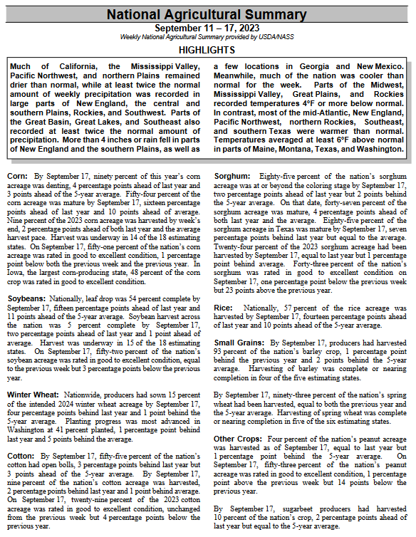
We begin with the National Agriculture Summary.  The Tables below the summary have additional data. The boxes with my comments may be incomplete so for crops of interest check the data out yourself to be sure.

Tonight, Tomorrow, Next Day, Five Days, and Intermediate-Term Outlooks for the U.S. and a Six-Day Forecast for the World: posted July 19, 2023

Updated at 5:10 p.m.  EDT Thursday, July 20, 2023. Sorry for the delay but remember this is a 48 to 72 hour forecast which usually changes slowly.

Here is what we are paying attention to in the next 48 to 72 hours. The article also includes weather maps for longer-term outlooks and a five-day
World weather outlook.

We start with the U.S. Information. You can update this section here but these are 48 to 72-hour forecasts so if I have not been able to update this area twice daily, what is shown is still valid and the images in the body of the article update automatically but sometimes they are a bit slow to update.

Short Range Forecast Discussion
NWS Weather Prediction Center College Park MD
145 PM EDT Thu Jul 20 2023

Valid 00Z Fri Jul 21 2023 – 00Z Sun Jul 23 2023

…The highest risk of flash flooding/severe storms should persist into
Thursday night in and near the Colorado/Kansas Border…

…Lengthy & dangerous heat wave to continue across the Southern Tier & in
the West…

…Cooler and more comfortable air-mass to engulf the Great Plains and
Midwest…

New Experimental Forecast Addresses the Impact of Global Warming on Marine Heat Waves – July 17, 2023

This is a somewhat confusing post that appeared in the NOAA Climate Blog which is intended to be informative and also announce a new NOAA website which you can access HERE. But we already know that the oceans are getting warmer due to Global warming. Oceans are three-dimensional. Are surface temperatures important other than the impact on the atmosphere? It is a new website but I think they have publicized it prematurely as it is IMO not fully developed. But it is a good start. They have a long way to go. But the topic is very important.

Here is the definition of a Marine Heat Wave:

“The marine heatwave (MHW) in the forecast is identified when sea surface temperature anomaly (with respect to the 1991-2020 monthly climatology) is above the MHW threshold. MHW thresholds specific to each month of the year are calculated as the 90th percentile of SST anomalies in a 3-month window (for example, for January MHWs, the 90th percentile of all December to February SST anomalies).” [Editor’s note: why 90%? That seems pretty arbitrary to me but it may be appropriate. I did not address the issue of

That is reasonable enough. In the blog article, they show the forecast for September and what it would be if we did not have Global Warming. But the counterfactual only compares the forecast to thirty or so years ago so it is a stretch to call this with and without Global Warming. But it does call attention to the problem of oceans that are warming.

First, we take a look at the current situation:

 Not sure why they use a different color scheme. Not sure why they do not show the World. And we are in El Nino.

Then the with and without Global Warming for September of this year.

The yellow and orange colors show what NOAA calls Marine Heat Waves.  Of interest is the Atlantic Ocean which would be a major hurricane maker if not for the El Nino which blows the tops off of developing hurricanes. We expect to see the El Nino warm tongue off of Peru during an El Nino. But there are a lot of other areas that are yellow and orange but some of that is the IOD. I do not like the color coding that was used. I find the graphic confusing. I will get used to it. BTW it shows PDO Negative, unfortunately.


This is quite different and makes the point. But oceans are 3D and I prefer the way JAMSTEC handles it with layers of the ocean. NOAA probably does that as well but so far they have not figured out how to display it. And of course, 3D is difficult to display. I think they should show the legend with both graphics.

Tonight, Tomorrow, Next Day, Five Days, and Intermediate-Term Outlooks for the U.S. and a Six-Day Forecast for the World: posted July 17, 2023

Here is what we are paying attention to in the next 48 to 72 hours. The article also includes weather maps for longer-term outlooks and a five-day
World weather outlook.

We start with the U.S. Information. You can update this section here but these are 48 to 72-hour forecasts so if I have not been able to update this area twice daily, what is shown is still valid and the images in the body of the article update automatically but sometimes they are a bit slow to update.

Short Range Forecast Discussion
NWS Weather Prediction Center College Park MD
421 PM EDT Sun Jul 16 2023

Valid 00Z Mon Jul 17 2023 – 00Z Wed Jul 19 2023

…There is a Moderate Risk of excessive rainfall over parts of New
England on Sunday…

…There is a Slight Risk of severe thunderstorms over parts of New
England and Central Plains/Middle Mississippi Valley…

…Excessive Heat Warnings and Advisories from the Pacific Northwest,
California, and the Great Basin to parts of the Southern Plains, Central
Gulf Coast, and southern tip of Florida…

…Air Quality alerts over parts of the Northern High Plains, Upper
Midwest, and Ohio Valley…

Our Report on the JAMSTEC Three-Season Forecast – July 16, 2023

The Japan Agency for Marine-Earth Science and Technology, or JAMSTEC, is a Japanese national research institute for marine-earth science and technology

From the JAMSTEC Discussion:

As predicted, the recent observation confirms the development of the El Niño. The SINTEX-F ensemble mean predicts that the El Niño will reach the peak in August and persist at least until the next boreal spring. However, there is a large uncertainty in the predicted amplitude.

Although it is a World forecast, it includes a forecast for North America since North America is part of the World.

First, we take a look at the forecasted sea surface temperature anomalies (SSTA). JAMSTEC starts by forecasting the SSTA and Nino 3.4 Index on the first day of the month and from there it takes their models about two weeks to produce their seasonal forecast. I received it from JAMSTEC on July 13, 2023.

This shows their forecast of sea surface temperature anomalies at three points in time. Red is warm and is associated with El Nino.  You can see the El Nino tongue of warm water extending from Peru to the west in all three time periods. It seems to be stronger in the 1st and 2nd time periods. The warmest water shifts west in the third period exhibiting Modoki characteristics. [I have similar information on their SSTA projections from NOAA but I usually do not include it in the article I write on the NOAA Seasonal Outlook because they do not seem to focus on it and their information does not extend as far into the future as does the information from JAMSTEC].  It is hard to find any blue in this set of forecasts but there is a bit of blue off of Baja California which is interesting.  JAMSTEC uses the same definition of Normal (climatology as NOAA). They do a better job at characterizing La Ninas and El Ninos than NOAA. JAMSTEC provides me with a lot of other information that I do not include in my articles to keep them to a manageable size for readers. Yesterday we published the NOAA ENSO Advisory and our article can be accessed HERE. In that article, Emily Becker commented on the generally warm oceans and how this may make predicting the strength and duration of an El Nino difficult.

Then we look at three forecasts. JAMSTEC tries to work with meteorological seasons and this month it does not line up perfectly. This means we do not have three full seasons of forecasts this month because the first three-month period overlaps the second one. ASO is one month of meteorological summer and two months of Autumn and SON is autumn. So we really have autumn and winter (DJF) with a forecast that is the transition to autumn.