NOAA Updates It’s ENSO Alert Status on January 9, 2025 – La Nina Has Finally Arrived They Say – Published on January 11, 2025

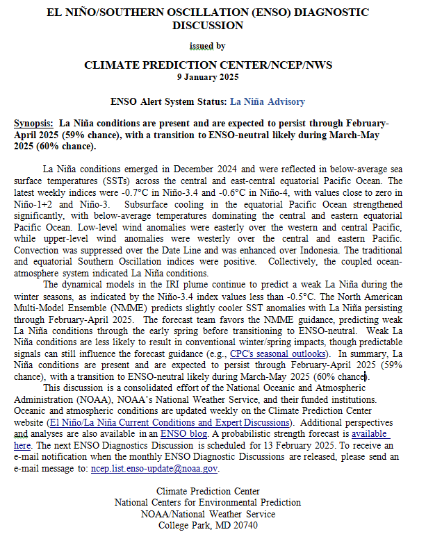
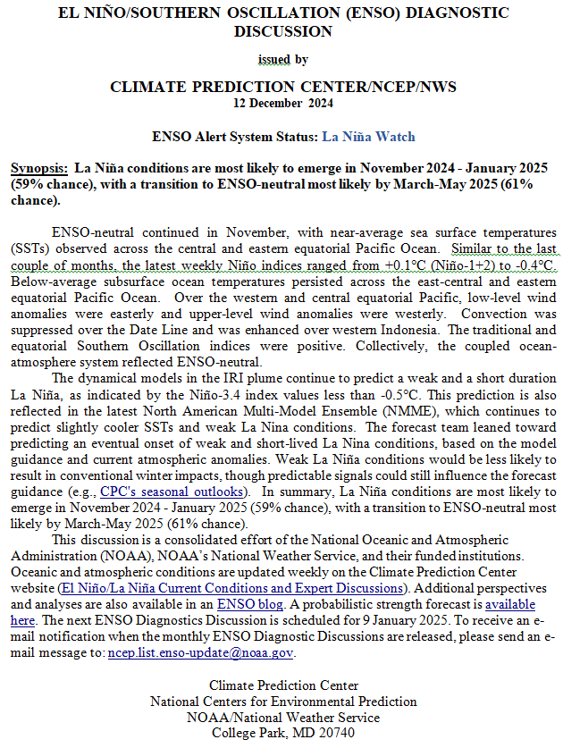
Synopsis:   La Niña conditions are present and are expected to persist through February-April 2025 (59% chance), with a transition to ENSO-neutral likely during March-May 2025 (60% chance).

So we are no longer in ENSO Neutral but officially in La Nina (but we may not stay in La Nina long enough for it to be recorded as an official La Nina for historical purposes.)

On the second Thursday of every month, NOAA (really their Climate Prediction Center CPC) issues its analysis of the status of ENSO. This includes determining the Alert System Status.  NOAA now describes their conclusion as “ENSO Alert System Status: La Nina”

It should increase the reliability of the Seasonal Outlook to be issued next Thursday. But will it?

We have included a very interesting ENSO Blog Post by Emily  Becker.

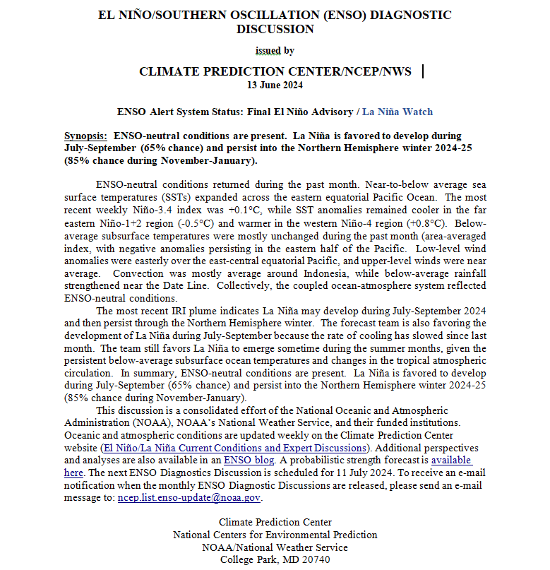
CLIMATE PREDICTION CENTER ENSO DISCUSSION (LINK)

The second paragraph is what is important:

“The dynamical models in the IRI plume continue to predict a weak La Niña during the winter seasons, as indicated by the Niño-3.4 index values less than -0.5°C . The North American Multi-Model Ensemble (NMME) predicts slightly cooler SST anomalies with La Niña persisting through February-April 2025.  The forecast team favors the NMME guidance, predicting weak La Niña conditions through the early spring before transitioning to ENSO-neutral.  Weak La Niña conditions are less likely to result in conventional winter/spring impacts, though predictable signals can still influence the forecast guidance (e.g., CPC’s seasonal outlooks).  In summary, La Niña conditions are present and are expected to persist through February-April 2025 (59% chance), with a transition to ENSO-neutral likely during March-May 2025 (60% chance). 

Below is the middle paragraph from the discussion last month.

“The dynamical models in the IRI plume continue to predict a weak and a short duration La Niña, as indicated by the Niño-3.4 index values less than -0.5°C. This prediction is also reflected in the latest North American Multi-Model Ensemble (NMME), which continues to predict slightly cooler SSTs and weak La Nina conditions.  The forecast team leaned toward predicting an eventual onset of weak and short-lived La Nina conditions, based on the model guidance and current atmospheric anomalies. Weak La Niña conditions would be less likely to result in conventional winter impacts, though predictable signals could still influence the forecast guidance (e.g., CPC’s seasonal outlooks).  In summary, La Niña conditions are most likely to emerge in November 2024 – January 2025 (59% chance), with a transition to ENSO-neutral most likely by March-May 2025 (61% chance).”

{Author’s Note: Has anything really changed?]

We now provide additional details.

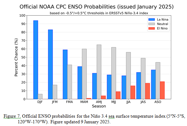
CPC Probability Distribution

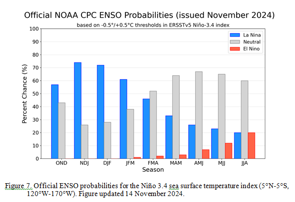
Here are the new forecast probabilities. The probabilities are for three-month periods e.g. NDJ stands for November/December/January.

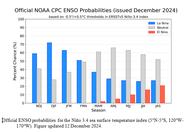
Here is the forecast from last month.

The analysis this month and last month are fairly similar.  But a future El Nino is a bit more in the picture.

Some will need to click on “Read More” to read the rest of this article.

NOAA Updates its ENSO Alert on December 12, 2024 – Will it be or not? – Published on December 13, 2024

Synopsis:   La Niña conditions are most likely to emerge in November 2024 – January 2025 (59% chance), with a transition to ENSO-neutral most likely by March-May 2025 (61% chance).

So we continue to be in ENSO Neutral but NOAA may not want to admit their forecast was wrong so they present it as waiting for La Nina. It is correct that we are in La Nina Watch but it is also correct that we currently still remain in ENSO Neutral.

On the second Thursday of every month, NOAA (really their Climate Prediction Center CPC) issues its analysis of the status of ENSO. This includes determining the Alert System Status.  NOAA now describes their conclusion as “ENSO Alert System Status: La Nino Watch”

The exact timing of the transition is now perhaps more clear but maybe not.  It should increase the reliability of the Seasonal Outlook to be issued next Thursday. But will it?

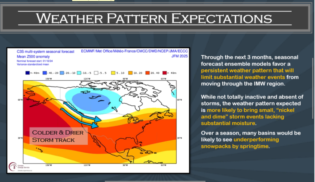
BTW this is the Copernicus view of the next three months.


The above is a consolidation of a number of models including one of the U.S. models but it is dominated by  European models. The format is different than what NOAA will present next week. It is more technical in nature. Basically this graphic shows the expected average storm track over the three-month period.  It also shows the expected deviation from normal of the level of the 500 MB ((Z500) of air- pressure which is pretty much the midpoint of the atmosphere. Z 500 is often the best way to forecast weather. Remember this is not a weather forecast but a forecast of the average air pressure for the three months.  It will vary from day to day and week to week but the storm track is expected to be further north which usually divides the cold and wet area from the warm and dry area but we are talking about anomalies. I suspect that the NOAA forecast which will be issued next Thursday will be similar to the above. It is suggesting a La Nina pattern.

We have included a very interesting ENSO Blog Post by Emily  Becker.

CLIMATE PREDICTION CENTER ENSO DISCUSSION (LINK)

The second paragraph is what is important:

“The dynamical models in the IRI plume continue to predict a weak and a short duration La Niña, as indicated by the Niño-3.4 index values less than -0.5°C. This prediction is also reflected in the latest North American Multi-Model Ensemble (NMME), which continues to predict slightly cooler SSTs and weak La Nina conditions.  The forecast team leaned toward predicting an eventual onset of weak and short-lived La Nina conditions, based on the model guidance and current atmospheric anomalies. Weak La Niña conditions would be less likely to result in conventional winter impacts, though predictable signals could still influence the forecast guidance (e.g., CPC’s seasonal outlooks).  In summary, La Niña conditions are most likely to emerge in November 2024 – January 2025 (59% chance), with a transition to ENSO-neutral most likely by March-May 2025 (61% chance).”

Below is the middle paragraph from the discussion last month.

“The IRI plume predicts a weak and short duration La Niña, as indicated by the Niño-3.4 index values less than -0.5°C. The latest North American Multi-Model Ensemble (NMME) forecasts are cooler than the IRI plume and predict a weak La Niña.  Due to this guidance and La Niña-like atmospheric circulation anomalies over the tropics, the team still favors the onset of La Niña, but it is likely to remain weak and have a shorter duration than other historical episodes.  A weak La Niña would be less likely to result in conventional winter impacts, though predictable signals could still influence the forecast guidance (e.g., CPC’s seasonal outlooks).  In summary, La Niña is most likely to emerge in October-December 2024 (57% chance) and is expected to persist through January-March 2025).”

We now provide additional details.

CPC Probability Distribution

Here are the new forecast probabilities. The probabilities are for three-month periods e.g. NDJ stands for November/December/January.

Here is the forecast from last month.

The analysis this month and last month are a bit different with again the transition to La Nina being slightly slower than thought last month. Also, the probabilities of a La Nina are lower than estimated last month. This seems to be a trend. The chart is clearer than the discussion in the summary report above.  The La Nina is a bit slower to arrive. I am not sure that we will actually have a La Nina.  However, one should read the Blog Post by Emily Becker, which is discussed later in this article.

Some will need to click on “Read More” to read the rest of this article.

NOAA Updates its ENSO Alert on July 11, 2024 – We are Now in La Nina Watch but the Expected Arrival Date has Been Delayed. – Published July 13, 2024

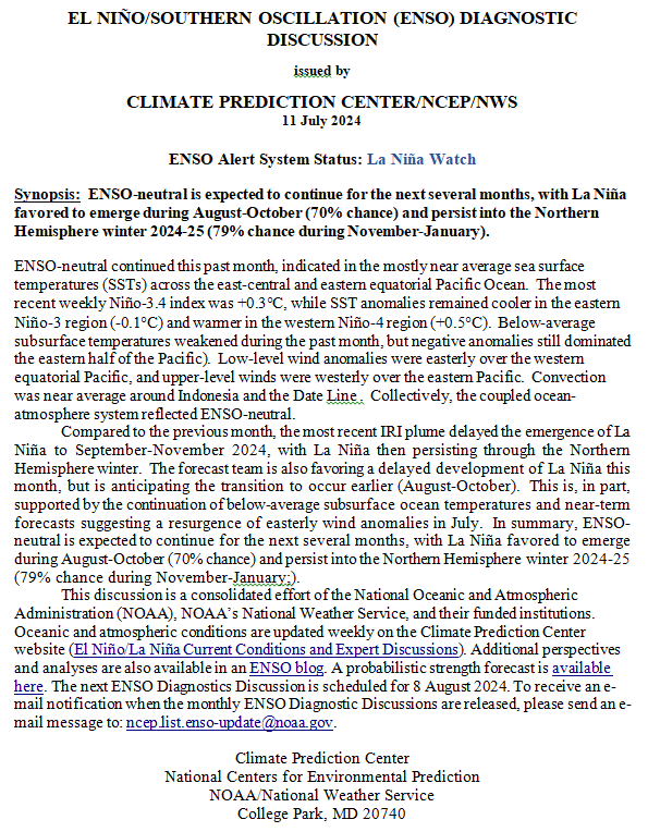
“Synopsis:  ENSO-neutral is expected to continue for the next several months, with La Niña favored to emerge during August-October (70% chance) and persist into the Northern Hemisphere winter 2024-25 (79% chance during November-January).”

So we are really in ENSO Neutral but NOAA may not want to admit their forecast was wrong so they present it this way. It is correct that we are in La Nina Watch but it is also correct that we currently remain in ENSO Neutral..

On the second Thursday of every month, NOAA (really their Climate Prediction Center CPC) issues its analysis of the status of ENSO. This includes determining the Alert System Status.  NOAA now describes their conclusion as “ENSO Alert System Status: La Nino Watch”

The exact timing of the transition is now less clear which should decrease the reliability of the Seasonal Outlook to be issued next Thursday.

We have included an ENSO Blog article by Emily Becker.

 >

CLIMATE PREDICTION CENTER ENSO DISCUSSION

The second paragraph is what is important:

“Compared to the previous month, the most recent IRI plume delayed the emergence of La Niña to September-November 2024, with La Niña then persisting through the Northern Hemisphere winter.  The forecast team is also favoring a delayed development of La Niña this month, but is anticipating the transition to occur earlier (August-October).  This is, in part, supported by the continuation of below-average subsurface ocean temperatures and near-term forecasts suggesting a resurgence of easterly wind anomalies in July.  In summary, ENSO-neutral is expected to continue for the next several months, with La Niña favored to emerge during August-October (70% chance) and persist into the Northern Hemisphere winter 2024-25 (79% chance during November-January).”

Below is the middle paragraph from the discussion last month.

“The most recent IRI plume indicates La Niña may develop during July-September 2024 and then persist through the Northern Hemisphere winter. The forecast team is also favoring the development of La Niña during July-September because the rate of cooling has slowed since last month. The team still favors La Niña to emerge sometime during the summer months, given the persistent below-average subsurface ocean temperatures and changes in the tropical atmospheric circulation. In summary, ENSO-neutral conditions are present. La Niña is favored to develop during July-September (65% chance) and persist into the Northern Hemisphere winter 2024-25 (85% chance during November-January; “

We now provide additional details.

CPC Probability Distribution

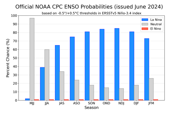
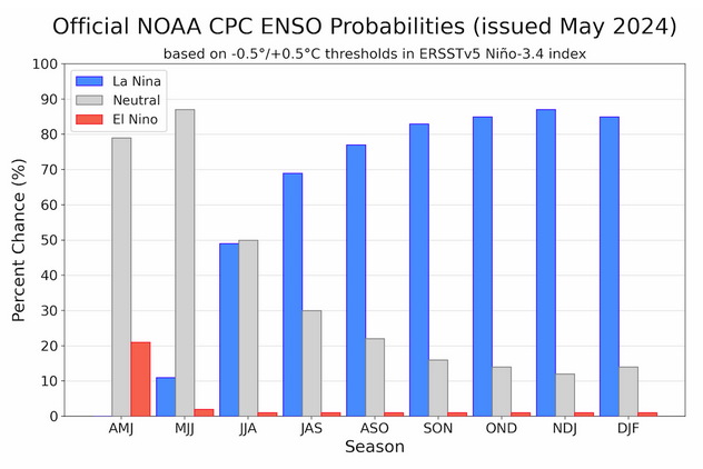
Here are the new forecast probabilities. The probabilities are for three-month periods e.g. JJA stands for June/July/August.

Here is the current release of the probabilities:

This chart shows the forecast progression of the evolution of ENSO from the current El Nino State to Neutral and by the summer to La Nina.  This kind of bar chart is not very good at showing uncertainty.

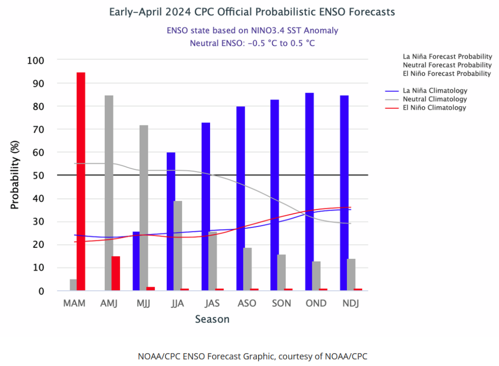
Here is the forecast from last month.

The analysis this month and last month are a bit different with again the transition to La Nina being slower than thought last month. This seems to be a trend. I am not sure that we will actually have a La Nina.

Some will need to click on “Read More” to read the rest of this article.

Our Report on the JAMSTEC Three-Season Forecast – Posted on June 22, 2024

The Japan Agency for Marine-Earth Science and Technology, or JAMSTEC, is a Japanese national research institute for marine-earth science and technology

From the JAMSTEC Discussion:

“The most recent observations indicate that the El Niño is now almost over, and there are weak signs of a La Niña. The SINTEX-F ensemble mean predicts that a La Niña Modoki will develop in the boreal autumn. However, there is a large uncertainty in the occurrence timing and amplitude.”

Although it is a World forecast, it includes a forecast for North America since North America is part of the World. One might try to compare it to the NOAA Outlook we published yesterday which can be accessed HERE.

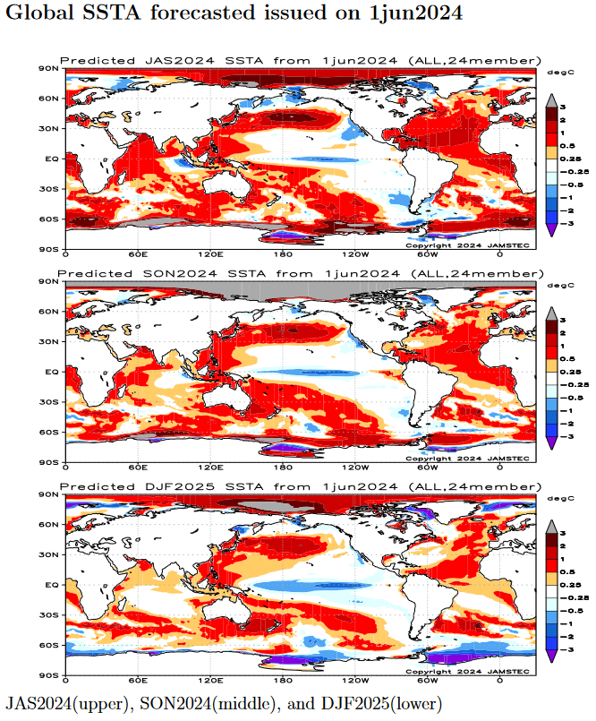
First, we take a look at the forecasted sea surface temperature anomalies (SSTA). JAMSTEC starts by forecasting the SSTA and Nino 3.4 Index on the first day of the month and from there it usually takes their models about two weeks to produce their seasonal forecast. I received it from JAMSTEC on May 14 close to when NOAA issued their Seasonal Update this month.  The JAMSTEC model runs are based on conditions as of June 1, 2024. The NOAA Seasonal Outlook is based on conditions closer to the time when it was issued.

We do not have a full three-season forecast from JAMSTEC this month. We have forecast maps for  JAS, SON and DJF so it is really an eight-month forecast as JAS and SON overlap a bit. For each of these three-month Outlooks, I also show the corresponding NOAA Outlook. The two are remarkably similar which is very unusual.

We also have single-month forecasts for July, August and September 2024. I have a single-month outlook for July from NOAA but not single-month outlooks for August and September so I did not show those comparisons.

Let’s take a look.

This shows their forecast of sea surface temperature anomalies at three points in time. Blue is cold and is associated with La Nina if it occurs in the Nino 3.4 measurement areas.  You no longer can see the El Nino tongue of warm water extending from Peru to the west in the JAS image but look at that blob of cool (anomaly) water to the west i.e. by this point in time this has Modoki characteristics that impact the Walker circulation. SON  and DJF also show La Nina but are increasingly to the west and may not be in the Nino 3.4 measurement area.  I have written about that before. It raises questions about the reliability of our current approach to thinking about the ENSO Cycle. This is covered in another article that can be accessed HERE. But JAMSTEC is showing a relatively normal ocean off the coast of much of the U.S. coasts which probably explains their forecast.

Of interest also is the cold water of the West Coast of the U.S. and the warm water between Africa and the north coast of South America.

JAMSTEC uses the same definition of Normal (climatology) as NOAA. JAMSTEC does a better job at characterizing La Ninas and El Ninos than NOAA. JAMSTEC provides me with a lot of other information that I do not include in my articles to keep them to a manageable size for readers. That material is the atmospheric pressure patterns.

Some Readers will have to click on “Read More” to read the rest of the article which you need to read to see the forecasts. I can only include a certain amount of material in the lede.

NOAA Updates its Seasonal Outlook on June 20, 2024 – Similar to the Outlook Issued last Month – Posted on June 21, 2024

On the third Thursday of the month right on schedule NOAA issued their updated Seasonal Outlook which I describe as their Four-Season Outlook because it extends a bit more than one year into the future. The information released also included the Mid-Month Outlook for the following month plus the weather and drought outlook for the next three months.  I present the information issued by NOAA and try to add context to it. It is quite a challenge for NOAA to address the subsequent month, the subsequent three-month period as well as the twelve successive three-month periods for a year or a bit more.

With respect to the long-term part of the Outlook which I call the Four-Season Outlook, there is a rapid transition from Neutral to LaNina. So getting the timing right is challenging. We are now in ENSO Neutral. La Nina is the likely scenario for this summer almost to the end of the forecast period. The Outlook beyond June has not been significantly changed from what was issued last month. This suggests increasing confidence in the outlook.  The forecast is a canonical La Nina plus trends.

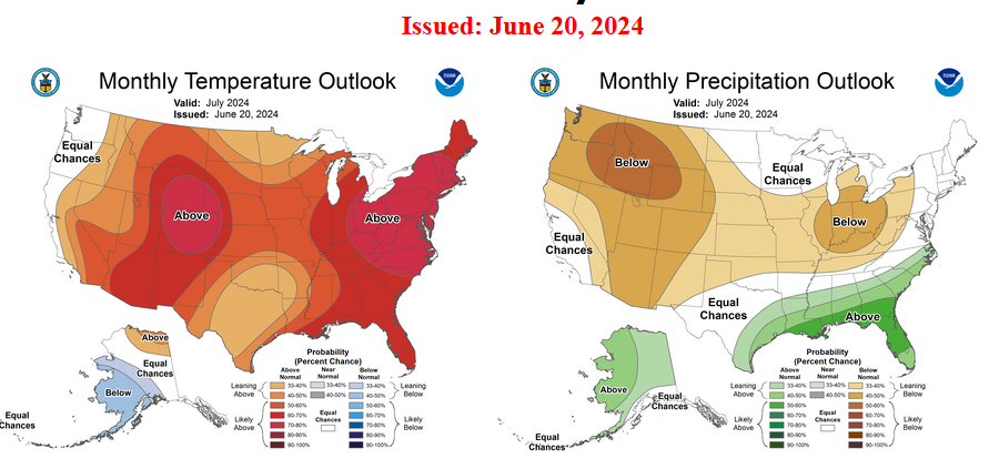
First, Let’s Take a Look at the (mid-month) Outlook for July

It will be updated on the last day of June.

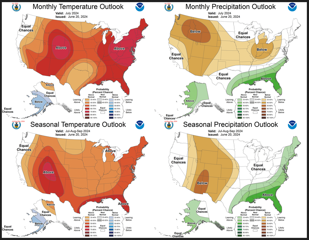
The top row is what is now called the Mid-Month Outlook for next month which will be updated at the end of this month. There is a temperature map and a precipitation map. The second row is a three-month outlook that includes next month.  I think the outlook maps are self-explanatory. What is important to remember is that they show deviations from the current definition of normal which is the period 1991 through 2020.  So this is not a forecast of the absolute value of temperature or precipitation but the change from what is defined as normal or to use the technical term “climatology”.

Notice that the Outlook for next month and the three-month Outlook are somewhat different, especially about precipitation.  This tells us that August and September will be different than July to some extent.

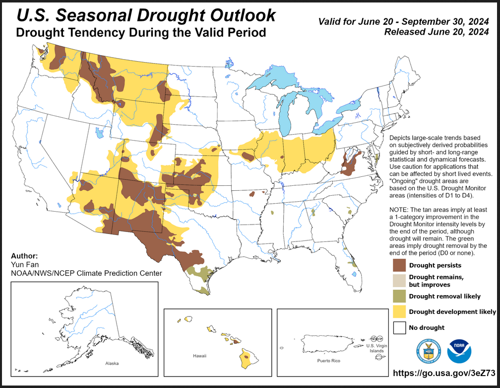
The expansion of the area impacted by drought is extensive.

The full NOAA Seasonal Outlook extends through July/August/September of 2025 (yes that is more than a year out). All of these maps are in the body of the article. Large maps are provided for July and the three-month period July/August/September.  Small maps are provided beyond that through July/August/September of 2025 with a link to get larger versions of these maps.

NOAA provides a discussion to support the maps. It is included in the body of this article. In some cases, one will need to click on “read more” to read the full article.  For those on my email list where I have sent the url of the article, that will not be necessary.

NOAA Updates its ENSO Alert on June 13, 2024 – The El Nino Advisory/La Nina Watch Continues but it is expected to be the Final El Nino Advisory – Published June 14, 2024

On the second Thursday of every month, NOAA (really their Climate Prediction Center CPC) issues its analysis of the status of ENSO. This includes determining the Alert System Status.  NOAA now describes their conclusion as “ENSO Alert System Status: Final El Nino Advisory/ La Nino Watch”

The exact timing of the transition is now fairly clear which should increase the reliability of the Seasonal Outlook to be issued next Thursday.

We have included an ENSO Blog article by

>

CLIMATE PREDICTION CENTER ENSO DISCUSSION


The second paragraph is what is important:

“The most recent IRI plume indicates La Niña may develop during July-September 2024 and then persist through the Northern Hemisphere winter. The forecast team is also favoring the development of La Niña during July-September because the rate of cooling has slowed since last month. The team still favors La Niña to emerge sometime during the summer months, given the persistent below-average subsurface ocean temperatures and changes in the tropical atmospheric circulation. In summary, ENSO-neutral conditions are present. La Niña is favored to develop during July-September (65% chance) and persist into the Northern Hemisphere winter 2024-25 (85% chance during November-January; ”

Below is the middle paragraph from the discussion last month.

“The most recent IRI plume favors an imminent transition to ENSO-neutral, with La Niña developing during July-September 2024 and then persisting through the Northern Hemisphere winter. The forecast team continues to favor the dynamical model guidance, which suggests La Niña could form as early as June-August 2024 [Author’s Note: slipped a month which is not a big surprise], with higher confidence of La Niña during the following seasons. La Niña generally tends to follow strong El Niño events, which also provides added confidence in the model guidance favoring La Niña. In summary, a transition from El Niño to ENSO-neutral is likely in the next month. La Niña may develop in June-August (49% chance) or July-September (69% chance).”

We now provide additional details.

CPC Probability Distribution

Here are the new forecast probabilities. The probabilities are for three-month periods e.g. MAM stands for March/April/May.

Here is the current release of the probabilities:

This chart shows the forecasted progression of the evolution of ENSO from the current El Nino State to Neutral and by the summer to La Nina.  This kind of bar chart is not very good at showing uncertainty.

Here is the forecast from last month.

The analysis this month and last month are a bit different with again the transition to La Nina being slower than thought last month.

Some will need to click on “Read More” to read the rest of this article.

NOAA Updates its ENSO Alert on May 9, 2024 – The El Nino Advisory/La Nina Watch Continues. – La Nina Onset a Bit Slower than Prior Estimate – Published May 10, 2024

On the second Thursday of every month, NOAA (really their Climate Prediction Center CPC) issues its analysis of the status of ENSO. This includes determining the Alert System Status.  NOAA again describes their conclusion as “ENSO Alert System Status: El Nino Advisory La Nino Watch”

The exact timing of the transition is not very clear which will impact the reliability of the Seasonal Outlook to be issued next Thursday. It does look like the onset may be slightly slower than thought last month. This may turn out to be a trend i.e. recognizing that the onset will be less rapid than previously thought. I am just guessing. It is difficult to predict how the phases of ENSO will unfold.

We have included an ENSO Blog article by Emily Becker.

>

CLIMATE PREDICTION CENTER ENSO DISCUSSION


The second paragraph is what is important:

“The most recent IRI plume favors an imminent transition to ENSO-neutral, with La Niña developing during July-September 2024 and then persisting through the Northern Hemisphere winter. The forecast team continues to favor the dynamical model guidance, which suggests La Niña could form as early as June-August 2024, with higher confidence of La Niña during the following seasons. La Niña generally tends to follow strong El Niño events, which also provides added confidence in the model guidance favoring La Niña. In summary, a transition from El Niño to ENSO-neutral is likely in the next month. La Niña may develop in June-August (49% chance) or July-September (69% chance).”

Below is the middle paragraph from the discussion last month.

“The most recent IRI plume indicates a transition to ENSO-neutral during spring 2024, with La Niña potentially developing during late summer 2024.  The forecast team continues to favor the dynamical model guidance, which is slightly more accurate than statistical models during this time of year.  La Niña tends to follow strong El Niño events, which also provides added confidence in the model guidance favoring La Niña.  In summary, a transition from El Niño to ENSO-neutral is likely by April-June 2024 (85% chance), with the odds of La Niña developing by June-August 2024 (60% chance).”

We now provide additional details.

CPC Probability Distribution

Here are the new forecast probabilities. The probabilities are for three-month periods e.g. MAM stands for March/April/May.

Here is the current release of the probabilities:

This chart shows the forecasted progression of the evolution of ENSO from the current El Nino State to Neutral and by the summer to La Nina.  This kind of bar chart is not very good at showing uncertainty.

Here is the forecast from last month.

The analysis this month and last month are not very different.
Click on “Read More” to read the rest of this article.

NOAA Updates its ENSO Alert on April 11, 2024 – The El Nino Advisory/La Nina Watch Continues. Not Much Change on the Timing – Published April 11, 2024

On the second Thursday of every month, NOAA (really their Climate Prediction Center CPC) issues its analysis of the status of ENSO. This includes determining the Alert System Status.  NOAA again describes their conclusion as “ENSO Alert System Status: El Nino Advisory La Nino Watch”

The exact timing of the transition is not very clear which will impact the reliability of the Seasonal Outlook to be issued next Thursday.

We have included an ENSO Blog article by Emily Becker that includes two very interesting animations. .


CLIMATE PREDICTION CENTER ENSO DISCUSSION

The second paragraph is what is important:

“The most recent IRI plume indicates a transition to ENSO-neutral during spring 2024, with La Niña potentially developing during late summer 2024.  The forecast team continues to favor the dynamical model guidance, which is slightly more accurate than statistical models during this time of year.  La Niña tends to follow strong El Niño events, which also provides added confidence in the model guidance favoring La Niña.  In summary, a transition from El Niño to ENSO-neutral is likely by April-June 2024 (85% chance), with the odds of La Niña developing by June-August 2024 (60% chance).”

Below is the middle paragraph from the discussion last month.

“The most recent IRI plume indicates a transition to ENSO-neutral during spring 2024, with La Niña potentially developing during summer 2024 .  While different types of models suggest La Niña will develop, the forecast team favors the dynamical model guidance, which is slightly more accurate for forecasts made during this time of year.  Even though forecasts made through the spring season tend to be less reliable, there is a historical tendency for La Niña to follow strong El Niño events.  In summary, a transition from El Niño to ENSO-neutral is likely by April-June 2024 (83% chance), with the odds of La Niña developing by June-August 2024 (62% chance).”

We now provide additional details.  The level of uncertainty with respect to how this El Nino will play out has changed a bit. NOAA is not quite as confident that we will have a LaNina. It is a slight change.

CPC Probability Distribution

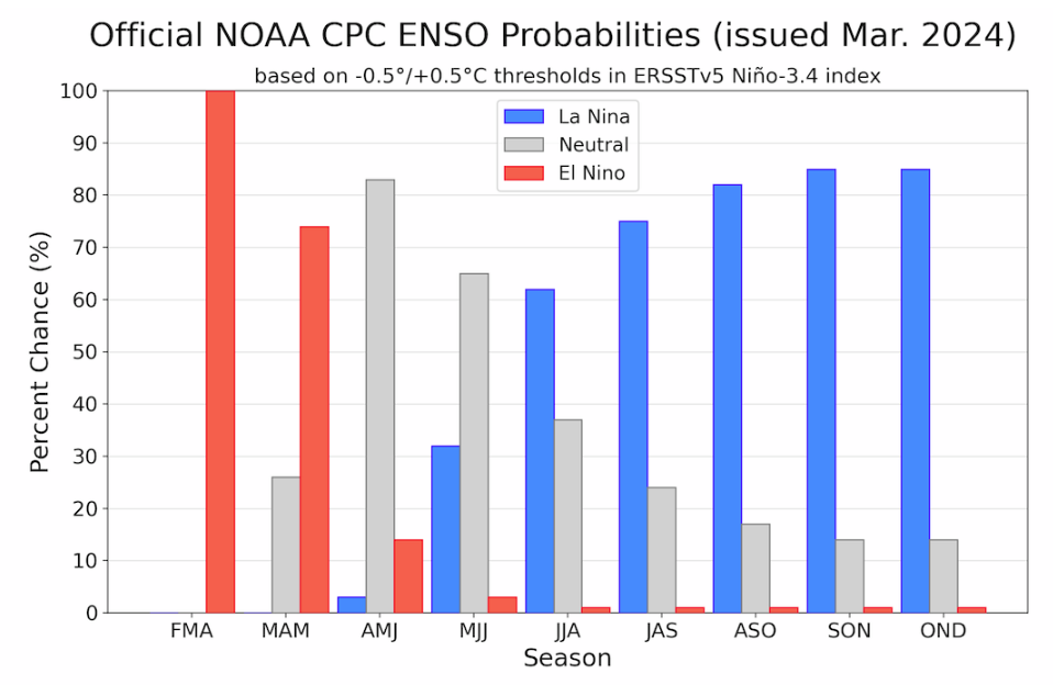
Here are the new forecast probabilities. The probabilities are for three-month periods e.g. MAM stands for March/April/May.

Here is the current release of the probabilities:

This chart shows the forecasted progression of the evolution of ENSO from the current El Nino State to Neutral and by the summer to La Nina.  This kind of bar chart is not very good at showing uncertainty.

Here is the forecast from last month.

The analysis this month and last month are not very different.
Click on “Read More” to read the rest of this article.

NOAA Updates its ENSO Alert on February 8, 2024 – The El Nino Advisory Continues. The La Nina Watch Begins – Timing of the Transition is Uncertain

On the second Thursday of every month, NOAA (really their Climate Prediction Center CPC) issues its analysis of the status of ENSO. This includes determining the Alert System Status.  NOAA again describes their conclusion as “ENSO Alert System Status: El Nino Advisory La Nino Watch”

The timing of the transition is not very clear which will impact the reliability of the Seasonal Outlook to be issued next Thursday.

We have included an interesting animation from and a link to an ENSO Blog article by Tom Liberto


CLIMATE PREDICTION CENTER ENSO DISCUSSION

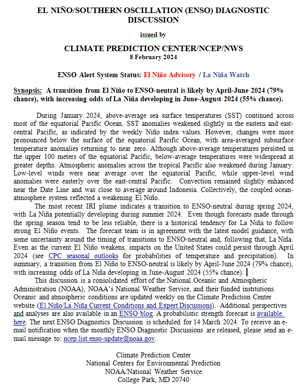
The second paragraph is what is important:

“The most recent IRI plume indicates a transition to ENSO-neutral during spring 2024, with La Niña potentially developing during summer 2024.  Even though forecasts made through the spring season tend to be less reliable, there is a historical tendency for La Niña to follow strong El Niño events.  The forecast team is in agreement with the latest model guidance, with some uncertainty around the timing of transitions to ENSO-neutral and, following that, La Niña.  Even as the current El Niño weakens, impacts on the United States could persist through April 2024 (see CPC seasonal outlooks for probabilities of temperature and precipitation).  In summary, a transition from El Niño to ENSO-neutral is likely by April-June 2024 (79% chance), with increasing odds of La Niña developing in June-August 2024 (55% chance).”

Below is the middle paragraph from the discussion last month.

“The most recent IRI plume indicates El Niño will gradually weaken and then transition to ENSO-neutral during spring 2024 .  Some state-of the-art dynamical climate models suggest a transition to ENSO-neutral as soon as March-May 2024.  The forecast team, however, delays this timing and strongly favors a transition to ENSO-neutral in April-June 2024.  There are also increasing odds of La Niña in the seasons following a shift to ENSO-neutral.  It is typical for El Niño to peak in December/early January, but despite weakening, its impacts on the United States could last through April (see CPC seasonal outlooks for probabilities of temperature and precipitation).  In summary, El Niño is expected to continue for the next several seasons, with ENSO-neutral favored during April-June 2024 (73% chance).”

We now provide additional details.  The level of uncertainty with respect to how this El Nino will play out has increased a bit.

CPC Probability Distribution

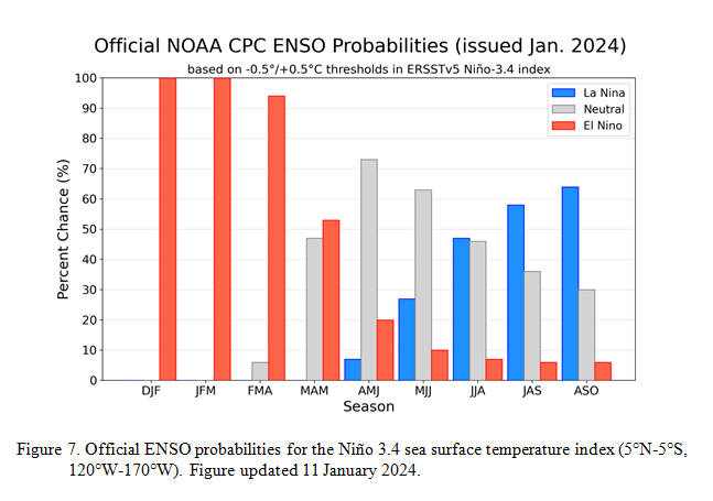
Here are the new forecast probabilities. The probabilities are for three-month periods e.g. JFM stands for January/February/March.

Here is the current release of the probabilities:

This chart shows the forecasted progression of the evolution of ENSO from the current El Nino State to Neutral and by the summer to La Nina.  This kind of  bar chart is not very good at showing uncertainty.

Here is the forecast from last month.

The analysis this month and last month are different.  This month the probability of El Nino in MAM is much more than was expected last month.  That is important.

What about El Nino? September 23, 2023

Since it is almost certain we will have El Nino this winter and a strong one at that, it is useful to think about what that means for precipitation in the lower 48 states.

The above shows El Nino winters from 1950 to today organized from upper left to lower right by the strength of the ENSO ONI Index. It may be missing one or even two recent El Ninos. I know how to create this sort of graphic but I prefer to use one that has been created by others. The point is that there is a lot of variation among El Nino winters. In the past, I have done an analysis for the state where I live which is New Mexico to see if the phases of the AMO and PDO seem to have an impact and they do. I am not aware of any published paper on that subject. I have seen papers that look at the impact of the Hawaiin High on how wet certain parts of California get during an El Nino. The fact is we do not really know how El Nino works partly because we have so few El Nino winters to analyze.