Our Report on the JAMSTEC Three-Season Forecast – Can be Compared to the NOAA Outlook – Posted on Nov 16, 2024

The Japan Agency for Marine-Earth Science and Technology, or JAMSTEC, is a Japanese national research institute for marine-earth science and technology
From the JAMSTEC Discussion:
“Recent observations show weak signs of La Niña. The SINTEX-F ensemble mean predicts that a weak La Niña Modoki will develop during the boreal winter, but there is uncertainty in the timing and amplitude of the event. The tropical Pacific will then be in a neutral state during the boreal spring and summer.”
Although it is a World forecast, it includes a forecast for North America since North America is part of the World. One might try to compare it to the NOAA Outlook when we publish the NOAA Outlook.
First, we take a look at the forecasted sea surface temperature anomalies (SSTA). JAMSTEC starts by forecasting the SSTA and Nino 3.4 Index on the first day of the month and from there it usually takes their models about two weeks to produce their seasonal forecast. I received it from JAMSTEC on November 12, 2024 which is before NOAA has issued their four-season update this month. The JAMSTEC model runs are based on conditions as of November 1, 2024. The NOAA Seasonal Outlook is based on conditions closer to the time when it will be issued.
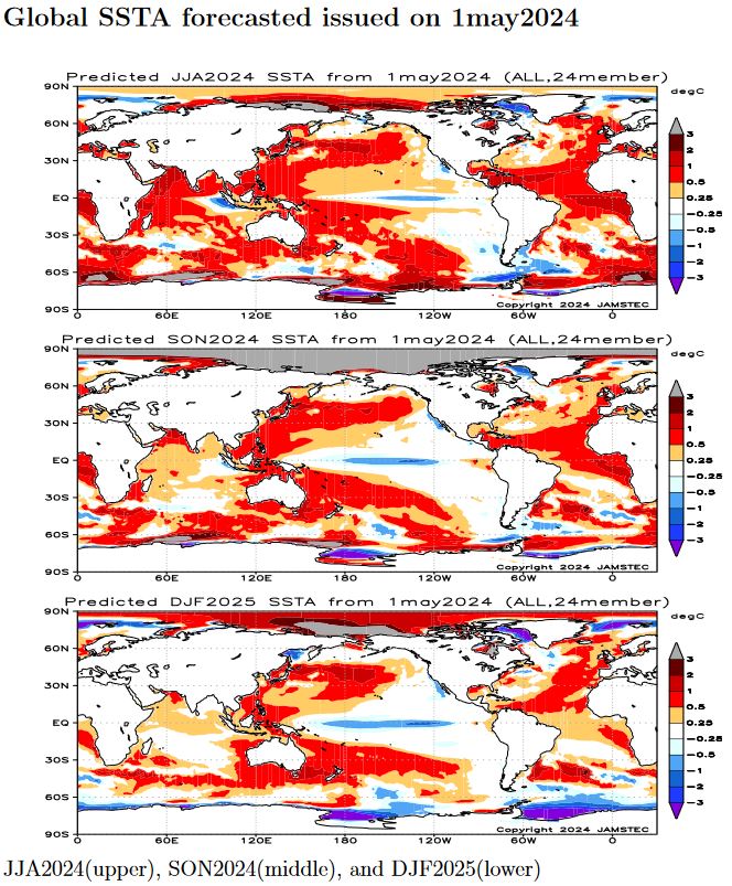
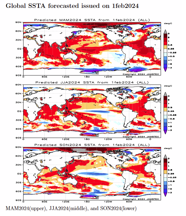
We have a full three-season forecast from JAMSTEC this month. We have forecast maps for DJF, MAM and JJA so it is really a three-season forecast.
We also have single-month JAMASTEC forecasts for December 2025 through May 2025 . I do not have the NOAA four season outlook yet so I could not do the comparisons but I might try doing that when the NOAA four-season Outlook is published.
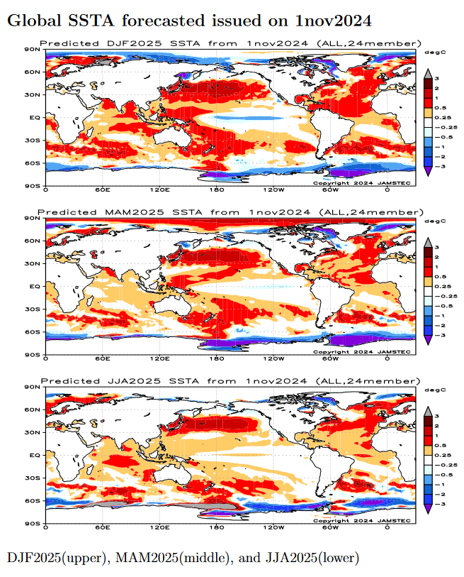
| This shows their forecast of sea surface temperature anomalies at three points in time. Blue is a cold anomaly and is associated with La Nina if it occurs in the Nino 3.4 measurement areas in the Pacific along the Equator. The cool anomaly along the Equator is somewhat further west than usual which gives it the Modoki characteristics.
The U.S. funded some of the Modoki research but for some reason declines to mention it in their seasonal outlook discussions. In the DJF image above, look at that blob of cool (anomaly) water to the west along the Equator. Thus the La Nina has Modoki characteristics that impact the Walker circulation. I have written about that before. It raises questions about the reliability of our current approach to thinking about the ENSO Cycle. This is covered in another article that can be accessed HERE. It was also discussed in the most recent ENSO Update in the article by Emily Becker. That article can be accessed HERE. Of interest also is the neutrally cold water just off the West Coast of the U.S. and the warm water between Africa and the north coast of South America which can support tropical storms and hurricanes. NOAA publishes a similar SSTA analysis. It can be accessed HERE. JAMSTEC uses the same definition of Normal (climatology) as NOAA. JAMSTEC does a better job at characterizing La Ninas and El Ninos than NOAA. JAMSTEC provides me with a lot of other information that I do not include in my articles to keep them to a manageable size for readers. That material is the atmospheric pressure patterns. |