NOAA Updates its ENSO Alert on April 11, 2024 – The El Nino Advisory/La Nina Watch Continues. Not Much Change on the Timing – Published April 11, 2024

On the second Thursday of every month, NOAA (really their Climate Prediction Center CPC) issues its analysis of the status of ENSO. This includes determining the Alert System Status.  NOAA again describes their conclusion as “ENSO Alert System Status: El Nino Advisory La Nino Watch”

The exact timing of the transition is not very clear which will impact the reliability of the Seasonal Outlook to be issued next Thursday.

We have included an ENSO Blog article by Emily Becker that includes two very interesting animations. .
 

CLIMATE PREDICTION CENTER ENSO DISCUSSION

The second paragraph is what is important:

“The most recent IRI plume indicates a transition to ENSO-neutral during spring 2024, with La Niña potentially developing during late summer 2024.  The forecast team continues to favor the dynamical model guidance, which is slightly more accurate than statistical models during this time of year.  La Niña tends to follow strong El Niño events, which also provides added confidence in the model guidance favoring La Niña.  In summary, a transition from El Niño to ENSO-neutral is likely by April-June 2024 (85% chance), with the odds of La Niña developing by June-August 2024 (60% chance).”

Below is the middle paragraph from the discussion last month.

“The most recent IRI plume indicates a transition to ENSO-neutral during spring 2024, with La Niña potentially developing during summer 2024 .  While different types of models suggest La Niña will develop, the forecast team favors the dynamical model guidance, which is slightly more accurate for forecasts made during this time of year.  Even though forecasts made through the spring season tend to be less reliable, there is a historical tendency for La Niña to follow strong El Niño events.  In summary, a transition from El Niño to ENSO-neutral is likely by April-June 2024 (83% chance), with the odds of La Niña developing by June-August 2024 (62% chance).”

We now provide additional details.  The level of uncertainty with respect to how this El Nino will play out has changed a bit. NOAA is not quite as confident that we will have a LaNina. It is a slight change.

CPC Probability Distribution

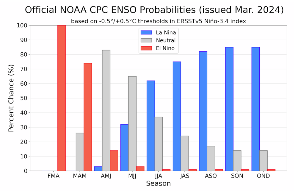
Here are the new forecast probabilities. The probabilities are for three-month periods e.g. MAM stands for March/April/May.
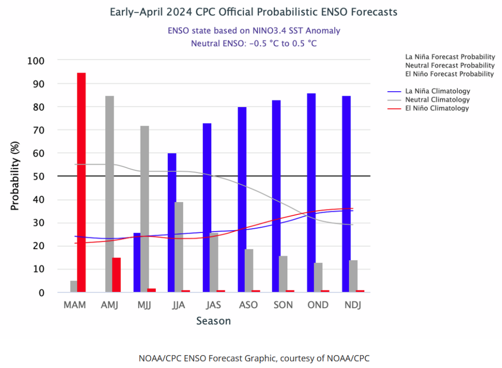
Here is the current release of the probabilities:

This chart shows the forecasted progression of the evolution of ENSO from the current El Nino State to Neutral and by the summer to La Nina.  This kind of bar chart is not very good at showing uncertainty.

Here is the forecast from last month.

The analysis this month and last month are not very different.
Click on “Read More” to read the rest of this article.

Is ENSO Static? Are they all Alike? Is there a Trend? – Posted on April 3, 2024

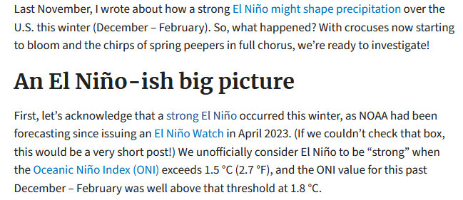
There was a very interesting blog post on ENSO.Gov that tries to assess this El Nino in the context of other El Ninos and I think they have done a very good job. I have reproduced the blog post in this article. Those who want access to any comments that have been submitted to that blog post can find the post HERE. Remember that all posts on the Climate.Gov ENSO Blog are attributed to the author who in this case is Nat Johnson. All the ENSO Blog posts are excellent. This one is beyond excellent.

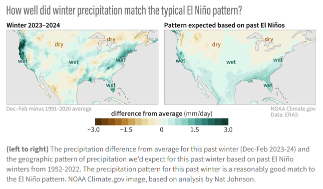
The above shows that the current El Nino which is winding down has been pretty close to what would be expected from a typical El Nino. It also shows how both the typical El Nino and the current El Nino compare to Normal or Climatology. You can easily see the differences. The analysis is for the Meteorological Winter months of December through February.

There is a lot more to this blog Post so some readers will need to click on “Read More” to access the rest of this very interesting analysis.  If you accessed this article via the url you will already have the full article and will not need to click on “Read More”.

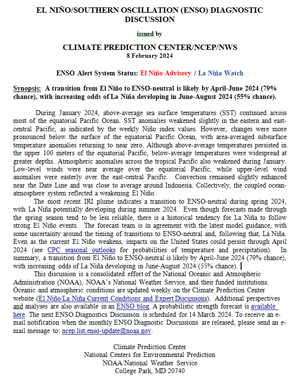
NOAA Updates its ENSO Alert on February 8, 2024 – The El Nino Advisory Continues. The La Nina Watch Begins – Timing of the Transition is Uncertain

On the second Thursday of every month, NOAA (really their Climate Prediction Center CPC) issues its analysis of the status of ENSO. This includes determining the Alert System Status.  NOAA again describes their conclusion as “ENSO Alert System Status: El Nino Advisory La Nino Watch”

The timing of the transition is not very clear which will impact the reliability of the Seasonal Outlook to be issued next Thursday.

We have included an interesting animation from and a link to an ENSO Blog article by Tom Liberto


CLIMATE PREDICTION CENTER ENSO DISCUSSION

The second paragraph is what is important:

“The most recent IRI plume indicates a transition to ENSO-neutral during spring 2024, with La Niña potentially developing during summer 2024.  Even though forecasts made through the spring season tend to be less reliable, there is a historical tendency for La Niña to follow strong El Niño events.  The forecast team is in agreement with the latest model guidance, with some uncertainty around the timing of transitions to ENSO-neutral and, following that, La Niña.  Even as the current El Niño weakens, impacts on the United States could persist through April 2024 (see CPC seasonal outlooks for probabilities of temperature and precipitation).  In summary, a transition from El Niño to ENSO-neutral is likely by April-June 2024 (79% chance), with increasing odds of La Niña developing in June-August 2024 (55% chance).”

Below is the middle paragraph from the discussion last month.

“The most recent IRI plume indicates El Niño will gradually weaken and then transition to ENSO-neutral during spring 2024 .  Some state-of the-art dynamical climate models suggest a transition to ENSO-neutral as soon as March-May 2024.  The forecast team, however, delays this timing and strongly favors a transition to ENSO-neutral in April-June 2024.  There are also increasing odds of La Niña in the seasons following a shift to ENSO-neutral.  It is typical for El Niño to peak in December/early January, but despite weakening, its impacts on the United States could last through April (see CPC seasonal outlooks for probabilities of temperature and precipitation).  In summary, El Niño is expected to continue for the next several seasons, with ENSO-neutral favored during April-June 2024 (73% chance).”

We now provide additional details.  The level of uncertainty with respect to how this El Nino will play out has increased a bit.

CPC Probability Distribution

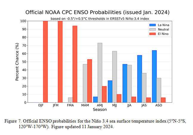
Here are the new forecast probabilities. The probabilities are for three-month periods e.g. JFM stands for January/February/March.

Here is the current release of the probabilities:

This chart shows the forecasted progression of the evolution of ENSO from the current El Nino State to Neutral and by the summer to La Nina.  This kind of  bar chart is not very good at showing uncertainty.

Here is the forecast from last month.

The analysis this month and last month are different.  This month the probability of El Nino in MAM is much more than was expected last month.  That is important.

NOAA Updates its ENSO Alert on January 11, 2024 – The El Nino Advisory Continues. Disagreement on When it Will End

On the second Thursday of every month, NOAA (really their Climate Prediction Center CPC) issues its analysis of the status of ENSO. This includes determining the Alert System Status.  NOAA again describes their conclusion as “ENSO Alert System Status: El Nino Advisory”

There is not much doubt that we have an El Nino. How long it lasts and its strength remains to be seen.  This El Nino has not become a Historical El Nino. We will try to address the slight confusion of when the El Nino will end in this article.

We have included some very interesting graphics from and a link to an interesting ENSO Blog article by Emily Becker.

CLIMATE PREDICTION CENTER ENSO DISCUSSION

The second paragraph is what is important:

“The most recent IRI plume indicates El Niño will gradually weaken and then transition to ENSO-neutral during spring 2024 .  Some state-of the-art dynamical climate models suggest a transition to ENSO-neutral as soon as March-May 2024.  The forecast team, however, delays this timing and strongly favors a transition to ENSO-neutral in April-June 2024.  There are also increasing odds of La Niña in the seasons following a shift to ENSO-neutral.  It is typical for El Niño to peak in December/early January, but despite weakening, its impacts on the United States could last through April (see CPC seasonal outlooks for probabilities of temperature and precipitation).  In summary, El Niño is expected to continue for the next several seasons, with ENSO-neutral favored during April-June 2024 (73% chance).

Below is the middle paragraph from the discussion last month.

” The most recent IRI plume favors El Niño to continue through the Northern Hemisphere winter 2023-24.  Based on the latest forecasts, there is now a 54% chance of a “historically strong” El Niño during the November-January season (³ 2.0°C in Niño-3.4).  An event of this strength would potentially be in the top 5 of El Niño events since 1950.  While stronger El Niño events increase the likelihood of El Niño-related climate anomalies, it does not imply expected impacts will emerge in all locations or be of strong intensity (see CPC seasonal outlooks for probabilities of temperature and precipitation).  In summary, El Niño is expected to continue through the Northern Hemisphere winter, with a transition to ENSO-neutral favored during April-June 2024 (60% chance;).”

We now provide additional detail.  The level of uncertainty with respect to how this El Nino will play out has increased quite a bit.

CPC Probability Distribution

Here are the new forecast probabilities. The probabilities are for three-month periods e.g. DJF stands for December/January/February.

Here is the current release of the probabilities:

This chart shows the forecasted progression of the evolution of ENSO from the current El Nino State to Neutral and by the summer to La Nina.

Here is the forecast from late last month.

The analysis this month and last month are different.  This month the probability of El Nino in MAM is much less than was expected last month.  That is important.

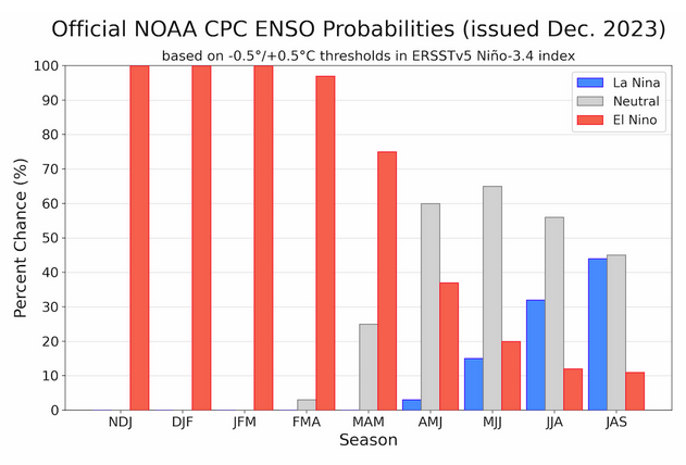
NOAA Updates its ENSO Alert on December 14, 2023 – The El Nino Advisory Continues. In a Week, NOAA Will Update us on how this Impacts U.S. Weather

On the second Thursday of every month, NOAA (really their Climate Prediction Center CPC) issues its analysis of the status of ENSO. This includes determining the Alert System Status.  NOAA again describes their conclusion as “ENSO Alert System Status: El Nino Advisory”

There is not much doubt that we have an El Nino. How long it lasts and its strength remains to be seen. NOAA may be more conservative compared to some other Weather Advisory Organizations. Some of the other Weather Advisory Organizations are predicting a higher probability for a “Historically Strong” El Nino. I personally believe that this El Nino will be somewhat of an underachiever. We will be finding out over the next two months.

We have included a link to an interesting ENSO Blog article by Emily Becker.

CLIMATE PREDICTION CENTER ENSO DISCUSSION


The second paragraph is what is important:

” The most recent IRI plume favors El Niño to continue through the Northern Hemisphere winter 2023-24.  Based on the latest forecasts, there is now a 54% chance of a “historically strong” El Niño during the November-January season (³ 2.0°C in Niño-3.4).  An event of this strength would potentially be in the top 5 of El Niño events since 1950.  While stronger El Niño events increase the likelihood of El Niño-related climate anomalies, it does not imply expected impacts will emerge in all locations or be of strong intensity (see CPC seasonal outlooks for probabilities of temperature and precipitation).  In summary, El Niño is expected to continue through the Northern Hemisphere winter, with a transition to ENSO-neutral favored during April-June 2024 (60% chance;).”

Below is the middle paragraph from the discussion last month. We see that this month there is an increased chance of a “historically strong” event.

“The most recent IRI plume favors El Niño to continue through the Northern Hemisphere spring 2024.  Based on latest forecasts, there is a greater than 55% chance of at least a “strong” El Niño (³ 1.5°C in Niño-3.4 for a seasonal average) persisting through January-March 2024.  There is a 35% chance of this event becoming “historically strong” (³ 2.0°C) for the November-January season.  Stronger El Niño events increase the likelihood of El Niño-related climate anomalies, but do not necessarily equate to strong impacts (see CPC seasonal outlooks for probabilities of temperature and precipitation).  In summary, El Niño is anticipated to continue through the Northern Hemisphere spring (with a 62% chance during April-June 2024.”

We now provide additional detail but I am keeping this article shorter than usual because nothing much has changed since last month.

CPC Probability Distribution

Here are the new forecast probabilities. The probabilities are for three-month periods e.g. OND stands for October/November/December.

Here is the current release of the probabilities:

You can clearly see the forecast does not extend beyond JAS 2024 and one does see a tail-off in the probabilities for El Nino conditions in the Eastern Pacific after the winter season. Is a return to La Nina in our future?

Here is the forecast from late last month.

The analysis this month and last month are pretty similar.

El Nino and Snowfall November 24, 2023 – It is a declining trend.

 We have previously looked at the impact of El Nino on precipitation. It was in THIS article. The key graphic was

Now we look at the impact of El Nino on snowfall. Even in the winter, not all precipitation falls as snow. This article is based on a blog post in ENSO BlOG at Climate.Gov by Michelle L’Heureux and Brian Brettschneider. We are only going to present the four key graphics in that Blog Post

You can read the full ENSO BLOG post HERE  For some readers, you will have to hit “Read More” to see the rest of my article.

NOAA Updates Its Seasonal Outlook on November 16, 2023 – El Nino Weather through Late Spring

On the third Thursday of the month right on schedule NOAA issued their updated Seasonal Outlook which I describe as their Four-Season Outlook because it extends a bit more than one year into the future. The information released also included the Mid-Month Outlook for the following month plus the weather and drought outlook for the next three months.  I present the information issued by NOAA and try to add context to it. It is quite a challenge for NOAA to address the subsequent month, the subsequent three-month period as well as the twelve successive three-month periods for a year or a bit more.

First, Let’s Take a Look at the (mid-month) Outlook for December. It will be updated on the last day of November.

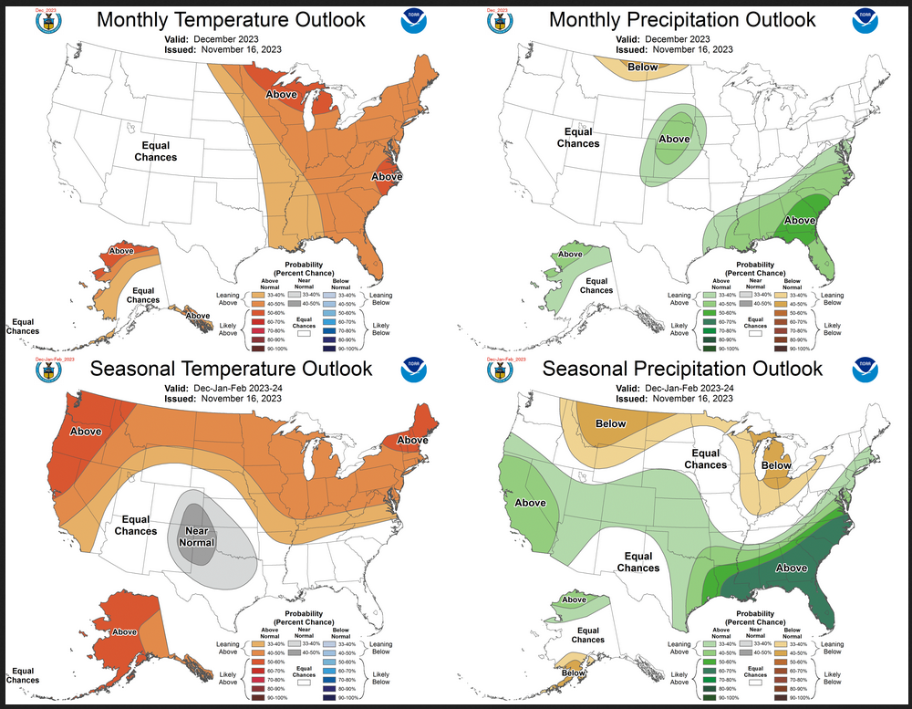
Then I present a graphic that shows both the preliminary Outlook for December and the three-month outlook for DJF 2023-2024. So you get the full picture in one graphic. For some, that may be all they are interested in. Others will be interested in the longer-term predictions and also the rationale supporting the predictions which is mostly provided by the NOAA discussion.

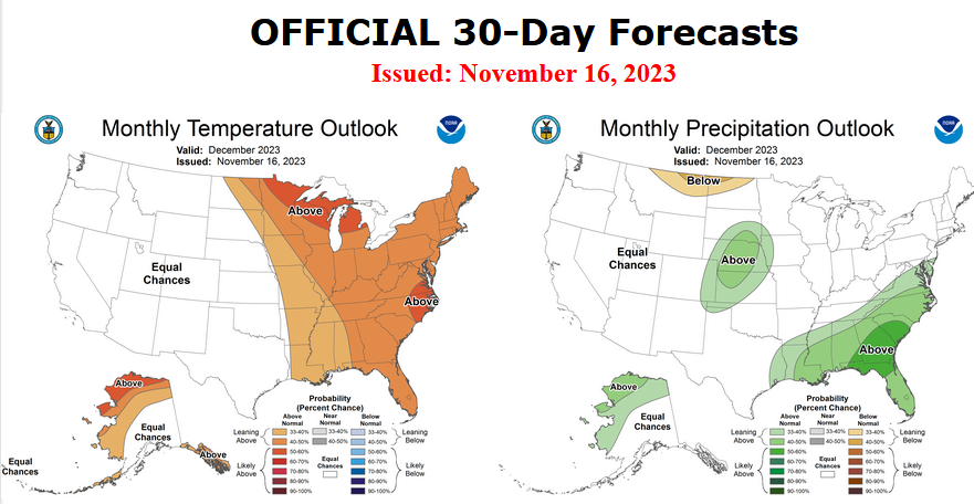
The top row is what is now called the Mid-Month Outlook for next month which will be updated at the end of this month. There is a temperature map and a precipitation map. The second row is a three-month outlook that includes next month.  I think the outlook maps are self-explanatory. What is important to remember is that they show deviations from the current definition of normal which is the period 1991 through 2020.  So this is not a forecast of the absolute value of temperature or precipitation but the change from what is defined as normal or to use the technical term “climatology”.

Notice that the outlook for next month and the three-month outlooks are somewhat different with respect to temperature and also to some extent precipitation.  This tells us that January and February will be different than December to some extent.

The full NOAA Seasonal Outlook extends through December/January/February of 2025. All of these maps are in the body of the article. Large maps are there for December and the three-month period Dec/Jan/Feb.  Small maps are provided beyond that through February of 2025 with a link to get larger versions of these maps.

NOAA provides an excellent discussion to support the maps.[Author’s Note: many other meteorological agencies see this El Nino being stronger than NOAA does so there is more than usual uncertainty relating to the more distant months.]

Potential Winter El Niño Impacts Across the North Central U.S. (Midwest, Missouri Basin, Great Lakes) November 4, 2023

I wish I had this for all regions but only three regions prepared this report so I am working with what I have. There is a separate but similar report for three areas: The Great Lakes, the Missouri Basin, and the Midwest.

I could have organized the graphics differently to highlight the differences among the three regions but I present the information as received and I think that works also.

The information presented will help a reader understand what is presented in the NOAA CPC Seasonal Outlooks and may provide some additional information for where they live in these regions.


NOAA Updates its ENSO Alert on October 12, 2023 – The El Nino Advisory Continues. In a Week, NOAA Will Update us on how this Impacts U.S. Weather

On the second Thursday of every month, NOAA (really their Climate Prediction Center CPC) issues its analysis of the status of ENSO. This includes determining the Alert System Status.  NOAA again describes their conclusion as “ENSO Alert System Status: El Nino Advisory”

There is not much doubt that we have an El Nino. How long it lasts and its strength remains to be seen. NOAA may be more conservative compared to some other Weather Advisory Organizations. That is concerning as some of the other Weather Advisory Organizations are predicting a “Historically Strong” El Nino.

We have included an interesting ENSO Blog article by Emily Becker and a link to a fairly comprehensive article we wrote on El Nino back in September.

CLIMATE PREDICTION CENTER ENSO DISCUSSION

The second paragraph is what is important:

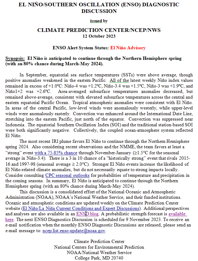
“The most recent IRI plume favors El Niño to continue through the Northern Hemisphere spring 2024.  Also considering recent observations and the NMME, the team favors at least a “strong” event with a 75-85% chance through November-January (≥1.5C for the seasonal average in Niño-3.4).  There is a 3 in 10 chance of a “historically strong” event that rivals 2015-16 and 1997-98 (seasonal average ≥ 2.0C).  Stronger El Niño events increase the likelihood of El Niño-related climate anomalies, but do not necessarily equate to strong impacts locally.  Consider consulting CPC seasonal outlooks for probabilities of temperature and precipitation in the coming seasons.  In summary, El Niño is anticipated to continue through the Northern Hemisphere spring (with an 80% chance during March-May 2024).”

Below is the middle paragraph from the discussion last month. We see that this month there is a substantial chance of a “historically strong” event.

“The most recent IRI plume indicates El Niño will persist through the Northern Hemisphere winter 2023-24.  Despite nearly the same ensemble mean amplitude as last month, the shorter forecast horizon means that the odds of at least a “strong” El Niño (≥1.5C for the November-January seasonal average in Niño-3.4) have increased to 71%.  However, a strong El Niño does not necessarily equate to strong impacts locally, with the odds of related climate anomalies often lower than the chances of El Niño itself (e.g., CPC’s seasonal outlooks).  In summary, El Niño is anticipated to continue through the Northern Hemisphere winter (with greater than 95% chance through January – March 2024; ).”

We now provide additional detail but I am keeping this article shorter than usual because nothing much has changed since last month.

CPC Probability Distribution

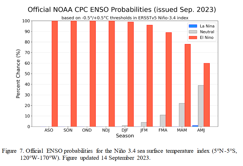
Here are the new forecast probabilities. This information in the past has been released twice a month and the first release is based on a survey of Meteorologists, the second is based on model results. The probabilities are for three-month periods e.g. ASO stands for August/September/October. The approach may have changed as IRI (The International Research Institute for Climate and Society, Columbia University Climate School) may no longer be involved.  Their website has not been updated this month.

Here is the current release of the probabilities:

You can clearly see the forecast does not extend beyond MJJ 2024 and one does see a tail-off in the probabilities for El Nino conditions in the Eastern Pacific after the winter season.

Here is the forecast from late last month.

The analysis this month and last month are pretty similar.

What about El Nino? September 23, 2023

Since it is almost certain we will have El Nino this winter and a strong one at that, it is useful to think about what that means for precipitation in the lower 48 states.

The above shows El Nino winters from 1950 to today organized from upper left to lower right by the strength of the ENSO ONI Index. It may be missing one or even two recent El Ninos. I know how to create this sort of graphic but I prefer to use one that has been created by others. The point is that there is a lot of variation among El Nino winters. In the past, I have done an analysis for the state where I live which is New Mexico to see if the phases of the AMO and PDO seem to have an impact and they do. I am not aware of any published paper on that subject. I have seen papers that look at the impact of the Hawaiin High on how wet certain parts of California get during an El Nino. The fact is we do not really know how El Nino works partly because we have so few El Nino winters to analyze.