Looking Back at February 2024 Weather for the U.S. and the World – Posted on March 16, 2024

Much of the information in this report comes from the monthly emails I receive from John Bateman. He does public outreach for NOAA and in particular NCEI. I could find the same information and more on the NCEI website but John Bateman produces a good summary so I use it or most of it. I also add additional information from NCEI or other NOAA websites. At the end of the article, I provide two links that will get you to the full reports and much additional information.

I start with the trends of February Temperature looking at first CONUS, then all of North America and then the World both land and water.

This is the temperature trend for CONUS. There was a decrease for February in 2024 as compared to February in 2023. I show all the data for February starting with 1895.

This is the temperature trend for North America. It covers a larger geographical area but I find it easier to read.

The temperature for the world, land and water hit a new record.

To read the rest of this article some will have to click on “Read More”.

Today Through the Fourth Friday (22 to 28 days) Weather Outlook for the U.S. and a Six-Day Forecast for the World: posted March 16, 2024

It is difficult to find a more comprehensive Weather Outlook anywhere else with the ability to get a local 10-day Forecast also.

This article focuses on what we are paying attention to in the next 48 to 72 hours. The article also includes weather maps for longer-term U.S. outlooks and a six-day World weather outlook which can be very useful for travelers.

First the NWS Short Range Forecast. The afternoon NWS text update can be found here but it is unlikely to have changed very much. The images in this article automatically update.

Short Range Forecast Discussion
NWS Weather Prediction Center College Park MD
Sat Mar 16 2024
Valid 12Z Sat Mar 16 2024 – 12Z Mon Mar 18 2024

…Heavy mountain snow impacts the Four Corners and Southern Rockies this
weekend…

…Severe thunderstorms and heavy rain possible across southern Texas and
along the Gulf Coast…

…Mild weather continues across the Pacific Northwest and East Coast…

The lingering closed upper low located over the Desert Southwest is
forecast to remain mostly stationary this weekend and produce the
continued threat of heavy mountain snow from the Four Corners region to
the Southern Rockies. In particular, the high terrain of central/southern
Utah as well as the San Juan and Sangre de Cristo Mountains of Colorado
and New Mexico can expect treacherous conditions due to heavy snow.
Additional snowfall accumulations over a foot are expected for parts of
the Southern Rockies through Monday, with Winter Storm Warnings and Winter
Weather Advisories remaining in effect.

Meanwhile, a stalling cold front extending from the Southeast to southern
Texas will lead to at least a few more days of storminess for the Lone
Star State and remaining Gulf Coast region. The greatest severe weather
threat exists today across south-central Texas and the Middle Texas Coast,
where the Storm Prediction Center has highlighted a Slight Risk (level 2
of 5) for severe thunderstorms. Large hail, damaging winds, and isolated
tornadoes are possible within the strongest storms. Intense rainfall rates
falling over saturated ground may also lead to flash flooding and standing
water in urban areas throughout similar portions of Texas and stretching
into far southwest Louisiana. By Sunday, shower and thunderstorm activity
is expected to stretch along most of the Gulf Coast, with isolated to
scattered chances for severe weather and flash flooding. Given recent
rainfall, parts of southwest Louisiana and southeast Texas have been
designated as having a Slight Risk (level 2 of 4) for Excessive Rainfall.

The other notable system to impact the CONUS through early next week is
forecast to clip the Great Lakes and northern New England, producing
mostly light rain and snow showers as well as gusty winds and cooler
temperatures. Locally heavy snow is possible downwind of the Great Lakes
on Sunday and Monday. Before the chilly and below average airmass
progresses into the eastern third of the Nation on Monday, mild afternoon
temperatures into the 60s and 70s can be expected this weekend in the
East. More importantly, the cold airmass on the way will contain a morning
frost/freeze threat on Monday throughout the Midwest and Ohio Valley as
lows dip into the 20s and 30s.

Upper riding anchored over the Northwest will continue the warm and dry
pattern throughout the Pacific Northwest and northern Great Basin,
expanding into the northern High Plains on Monday. Highs into the 60s and
70s are forecast, which could break a few daily high temperature records.

To get your local forecast plus active alerts and warnings click HERE and enter your city, state or zip code.

Above is a 72 hour animation of the forecast. Learn about wave patterns HERE.

Then, looking at the world and of course, the U.S. shows here also. Today we are looking at precipitation.

Please click on “Read More” below to access the full Daily Report issued today.

15 Mar 2023 Market Close & Major Financial Headlines: Markets Opened Fractionally Lower, Continued The Downward Trend Line From Thursday’s Session, Finally Closing Moderately Lower

Summary Of the Markets Today:

  • The Dow closed down 191 points or 0.49%,
  • Nasdaq closed down 0.95%,
  • S&P 500 closed down 0.65%,
  • Gold $2,160 down $7.40,
  • WTI crude oil settled at $81 down $0.25,
  • 10-year U.S. Treasury 4.308% up 0.010 points,
  • USD index $103.44 up $0.080,
  • Bitcoin $68,630 down $1,080 (1.68%), – Historic high 73,798.25
  • Baker Hughes Rig Count: U.S. +7 to 629 Canada -18 to 207

*Stock data, cryptocurrency, and commodity prices at the market closing.


Click here to read our current Economic Forecast – March 2024 Economic Forecast: A Modest Improvement In Our Index Predicting Little Change In Main Street Growth


Today’s Economic Releases Compiled by Steven Hansen, Publisher:

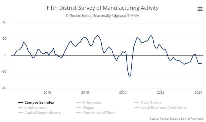
Industrial production remained down 0.2% year-over-year in February 2024. Manufacturing subindex continued in negative territory at -0.4% year-over-year. Utilities subindex increased to 0.8% gain year-over-year, and the mining subindex declined but was still up 1.4% year-over-year. Capacity utilization for the industrial sector remained at 78.3 percent in February, a rate that is 1.3 percentage points below its long-run (1972–2023) average. Manufacturing remains in a recession in the USA.

The New York Fed’s Empire State Manufacturing Survey for March 2024 showed the headline general business conditions index fell nineteen points to -20.9. Manufacturing remains in a recession in the USA.

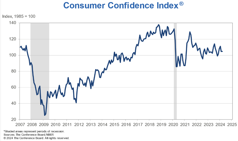
Michigan Consumer sentiment moved little this month with a 0.4 index point decrease that is well within the margin of error, and thus sentiment has been steady and essentially unchanged since January 2024. Sentiment remained almost 25% above November 2023 and is currently halfway between the historic low reached during the peak of inflation in June 2022 and pre-pandemic readings. Small improvements in personal finances were offset by modest declines in expectations for business conditions. After strong gains between November 2023 and January 2024, consumer views have stabilized into a holding pattern; consumers perceived few signals that the economy is currently improving or deteriorating. Indeed, many are withholding judgment about the trajectory of the economy, particularly in the long term, pending the results of this November’s election.

U.S. import prices declined 0.8% year-over-year in February 2024. Prices for U.S. exports declined 1.8% year-over-year.

Here is a summary of headlines we are reading today:

  • Bloomberg Survey: Brent To Exceed $80 By Year’s End
  • U.S. Oil, Gas Activity Picks Up But Slow Start to the Year
  • Bitcoin’s Success May Be Its Downfall
  • Court Halts New Mining Permits in Argentina’s Key Lithium Region
  • EU Warns of Heightened Somali Piracy Threat to Shipping
  • S&P 500 closes lower on inflation worries, notches second straight weekly loss: Live updates
  • Bitcoin falls below $70,000 in overnight sell-off: CNBC Crypto World
  • Alaska’s ice road oil truckers are in a boom, and causing a backlash
  • Fisker Shares Surge On Talks With Large Automaker Following Bankruptcy Fears
  • McDonald’s blames global outage on third party
  • 10-year Treasury yield sees biggest weekly advance since October after hot U.S. data

Click on the “Read More” below to access these, other headlines, and the associated news summaries moving the markets today.

NOAA Updates its ENSO Alert on March 14, 2024 – The El Nino Advisory/La Nina Watch Continues. Not Much Change on the Timing – Published March 15, 2024

On the second Thursday of every month, NOAA (really their Climate Prediction Center CPC) issues its analysis of the status of ENSO. This includes determining the Alert System Status.  NOAA again describes their conclusion as “ENSO Alert System Status: El Nino Advisory La Nino Watch”

The exact timing of the transition is not very clear which will impact the reliability of the Seasonal Outlook to be issued next Thursday.

We have included an ENSO Blog article by Emily Becker.


CLIMATE PREDICTION CENTER ENSO DISCUSSION


The second paragraph is what is important:

“The most recent IRI plume indicates a transition to ENSO-neutral during spring 2024, with La Niña potentially developing during summer 2024 .  While different types of models suggest La Niña will develop, the forecast team favors the dynamical model guidance, which is slightly more accurate for forecasts made during this time of year.  Even though forecasts made through the spring season tend to be less reliable, there is a historical tendency for La Niña to follow strong El Niño events.  In summary, a transition from El Niño to ENSO-neutral is likely by April-June 2024 (83% chance), with the odds of La Niña developing by June-August 2024 (62% chance).”

Below is the middle paragraph from the discussion last month.

“The most recent IRI plume indicates a transition to ENSO-neutral during spring 2024, with La Niña potentially developing during summer 2024.  Even though forecasts made through the spring season tend to be less reliable, there is a historical tendency for La Niña to follow strong El Niño events.  The forecast team is in agreement with the latest model guidance, with some uncertainty around the timing of transitions to ENSO-neutral and, following that, La Niña.  Even as the current El Niño weakens, impacts on the United States could persist through April 2024 (see CPC seasonal outlooks for probabilities of temperature and precipitation).  In summary, a transition from El Niño to ENSO-neutral is likely by April-June 2024 (79% chance), with increasing odds of La Niña developing in June-August 2024 (55% chance).”

We now provide additional details.  The level of uncertainty with respect to how this El Nino will play out has not changed very much.

CPC Probability Distribution

Here are the new forecast probabilities. The probabilities are for three-month periods e.g. FMA stands for February/March/April.

Here is the current release of the probabilities:

This chart shows the forecasted progression of the evolution of ENSO from the current El Nino State to Neutral and by the summer to La Nina.  This kind of bar chart is not very good at showing uncertainty.

Here is the forecast from last month.

The analysis this month and last month are not very different.
Click on “Read More” to read the rest of this article.

Today Through the Fourth Friday (22 to 28 days) Weather Outlook for the U.S. and a Six-Day Forecast for the World: posted March 15, 2024

It is difficult to find a more comprehensive Weather Outlook anywhere else with the ability to get a local 10-day Forecast also.

This article focuses on what we are paying attention to in the next 48 to 72 hours. The article also includes weather maps for longer-term U.S. outlooks and a six-day World weather outlook which can be very useful for travelers.

First the NWS Short Range Forecast. The afternoon NWS text update can be found here but it is unlikely to have changed very much. The images in this article automatically update.

Short Range Forecast Discussion
NWS Weather Prediction Center College Park MD
Fri Mar 15 2024
Valid 12Z Fri Mar 15 2024 – 12Z Sun Mar 17 2024

…Heavy mountain snow continues throughout the Four Corners region into
this weekend…

…Severe thunderstorm and excessive rainfall chances shift south into the
Southeast and Gulf Coast States…

…Mild weather continues across the Pacific Northwest and East Coast…

A meandering closed upper low spinning over the Desert Southwest will
continue to funnel moisture northward into the Four Corners region and
create additional chances for heavy mountain snow through the weekend.
Snow chances will diminish today across the central/southern High Plains
as upslope flow weakens, but mountainous terrain of the central and
southern Rockies can expect an additional 1 to 2 feet of snow through
Sunday. The higher elevations of southern Utah and Arizona can also expect
snowfall accumulations over a foot, which will create hazardous driving
conditions. Winter Storm Warnings and Winter Weather Advisories remain in
effect for these regions.

Farther east, waves of low pressure and an associated cold front are
forecast to slide south and east today while stretching from the
Mid-Atlantic to the Southern Plains. Heavy rain and scattered
thunderstorms will accompany this system, with the greatest chances for
severe weather and/or flash flooding located across parts of the Mid-South
and south-central Texas. For these areas, thunderstorms could be strong
enough to contain damaging wind gusts and isolated tornadoes. Meanwhile,
the primary risk across south-central Texas is expected to be associated
with large hail and scattered flash flooding. By this weekend, the
aforementioned frontal boundary is forecast to stall along the Gulf Coast
and southern Texas, resulting in additional chances for heavy rain that
could lead to scattered flooding concerns from south-central Texas to
southern Mississippi.

The other notable weather system to impact the Lower 48 will be a potent
low pressure system passing to the north of the Great Lakes on Saturday
and nearing Maine on Sunday. The greatest impacts are anticipated to be
associated with gusty winds across the Great Lakes and decreasing
temperatures throughout the Upper Midwest by Sunday. Additionally, periods
of lake effect snow could be locally heavy across the U.P. of Michigan
downwind of Lake Superior. Otherwise, strong southerly flow on the eastern
side of this system will keep much of the East Coast mild with high
temperatures mainly in the 60s and 70s. The other warm spots over the next
few days include the Pacific Northwest and Southeast, where a few daily
record highs are possible. Parts of western Washington and Oregon may see
highs into the mid-70s, while mid-to-upper 80s are found throughout the
Sunshine State.

To get your local forecast plus active alerts and warnings click HERE and enter your city, state or zip code.

Above is a 72 hour animation of the forecast. Learn about wave patterns HERE.

Then, looking at the world and of course, the U.S. shows here also. Today we are looking at precipitation.

Please click on “Read More” below to access the full Daily Report issued today.

14 Mar 2023 Market Close & Major Financial Headlines: Wall Street Opened Higher, Trended Down, Ending Session Moderately Down In The Red

Summary Of the Markets Today:

  • The Dow closed down 138 points or 0.35%,
  • Nasdaq closed down 0.30%,
  • S&P 500 closed down 0.29%,
  • Gold $2,167 down $13.50,
  • WTI crude oil settled at $81 up $1.40,
  • 10-year U.S. Treasury 4.292% up 0.100 points,
  • USD index $103.31 up $0.520,
  • Bitcoin $69,710 down $3,4841 (4.75%), New Historic high 73,798.25

*Stock data, cryptocurrency, and commodity prices at the market closing.


Click here to read our current Economic Forecast – March 2024 Economic Forecast: A Modest Improvement In Our Index Predicting Little Change In Main Street Growth


Today’s Economic Releases Compiled by Steven Hansen, Publisher:

Advance estimates of U.S. retail and food services sales for February 2024, adjusted for seasonal variation and holiday and trading-day differences, but not for price changes, were up 1.5% above February 2023 according to the US Census tables. However, using the St Louis Fed’s FRED database, retail sales are up 5.5% year-over-year in February 2024. Take your pick 🙂

In the week ending March 9, the advance figure for seasonally adjusted initial unemployment claims 4-week moving average was 208,000, a decrease of 500 from the previous week’s revised average. The previous week’s average was revised down by 3,750 from 212,250 to 208,500.

The Producer Price Index for final demand (PPI) advanced 1.6% for the 12 months ended in February 2024, the largest rise since moving up 1.8 percent for the 12 months ended September 2023. The rise in the PPI can be traced to oil prices.


Here is a summary of headlines we are reading today:

  • Brent Soars Past $85 As IEA Recalculates Supply, Demand
  • Gold Prices Soar Past $2,150 After Bullish Rally
  • Fourth Russian Lukoil Exec Found Dead by Apparent Suicide
  • U.S. Drivers Warned to Brace For Jump in Gasoline Prices
  • The U.S. Is Betting Big on Small Nuclear Reactors
  • Dow closes more than 100 points lower, snaps 3-day win streak after hot inflation report: Live updates
  • This week provided a reminder that inflation isn’t going away anytime soon
  • Bitcoin and ether fall as investors press pause on rally: CNBC Crypto World
  • ‘Bad News’ Is Bad News For Stocks, Bonds, Crypto, & Gold
  • How Overpaid Are State And Local Government Workers Compared To Private
  • Long-term Treasury yields jump by most in a month after hot producer-price report

Click on the “Read More” below to access these, other headlines, and the associated news summaries moving the markets today.
Climate context of the February 2024 megafire outbreak in Texas – Published March 14, 2024

Texas had some bad wildfires and Global Warming might have contributed to their problem.

I have reproduced the body of a Climate.Gov post on this and you can access the full article with comments HERE. But I have reproduced most of the article so you can find it in this article.

Some may need to click on “Read More” to be able to read the body of the article.

Today Through the Fourth Friday (22 to 28 days) Weather Outlook for the U.S. and a Six-Day Forecast for the World: posted March 14, 2024

It is difficult to find a more comprehensive Weather Outlook anywhere else with the ability to get a local 10-day Forecast also.

This article focuses on what we are paying attention to in the next 48 to 72 hours. The article also includes weather maps for longer-term U.S. outlooks and a six-day World weather outlook which can be very useful for travelers.

First the NWS Short Range Forecast. The afternoon NWS text update can be found here but it is unlikely to have changed very much. The images in this article automatically update.

Short Range Forecast Discussion
NWS Weather Prediction Center College Park MD
Thu Mar 14 2024
Valid 12Z Thu Mar 14 2024 – 12Z Sat Mar 16 2024

…Heavy snow through today from the central Rockies, the foothills, and
nearby High Plains before gradually tapering off on Friday…

…A long-duration event of mountain snow and lower-elevation rain
expected to develop over the Four Corners region beginning on Friday…

…Severe thunderstorms and excessive rainfall expected to push southward
from the east-central Plains this morning to the Arklatex region on
Friday, and into southeastern Texas by Saturday morning…

…Very mild/warm weather expands eastward from the central to the eastern
U.S. going into the weekend…

An amplifying upper-level trough continues to dig southward into the
western U.S. Moisture lifted ahead of the upper trough within a cold air
mass is producing heavy snow across the central Rockies early this
morning. As the cold air continues to filter southward, the rain that
initially falls over the lower elevations is forecast to change over to
heavy wet snow. The heaviest snow is forecast to be along the Front
Range of Colorado where a few feet of snow could accumulate. Lesser
amounts are expected in adjacent areas but one to two feet of wet snow can
be expected down into the Foothills and High Plains such as Boulder and
Denver, Colorado. Hazardous to very difficult travel is expected as heavy
snow and intense snow rates at times (1-2 inches plus per hour) will lead
to hazardous travel conditions.

By tonight into Friday, the main upper-level low is forecast to dip
further south into the Desert Southwest. Snow across the central
Rockies/High Plains is expected to gradually taper off as the dynamics of
the low move farther south. However, the Four Corners region will be
under the most favorable region for precipitation to form and expand
beginning on Friday as the upper low is forecast to meander over the
region. Mountain snow and lower elevation rain are expected to linger
over the Four Corners region going into the weekend.

On the warm side of the system, a low pressure system is developing over
the central Plains and tracking toward the Midwest. Influx of warm and
moist air from the Gulf of Mexico has
organized strong to severe thunderstorms ahead of a warm front. These
thunderstorms containing heavy rainfall are forecast to push southward
from the east-central Plains this morning to the Arklatex region on
Friday, and into southeastern Texas by Saturday morning near or just
behind an advancing cold front. Meanwhile, the low pressure system will
bring widespread rainfall across the southern half of the Great Lakes
today, spreading into New England tonight into Friday. The rain will
likely mix with wet snow across interior New England on Friday before the
system steadily moves off the coast early on Saturday.

As the winter storm develops over the western U.S., much of the eastern
U.S. will enter an extended period of very warm and pleasant weather.
High temperatures in the 60s and 70s from the Ohio Valley to the
Mid-Atlantic states will be 20-25 degrees above normal for this time of
year. However, a cold front from Canada is forecast to rapidly dip into
the northern Plains by early on Saturday. This cold front will signal the
beginning of a rapid cooling trend forecast to head toward the East Coast
thereafter.

To get your local forecast plus active alerts and warnings click HERE and enter your city, state or zip code.

Above is a 72 hour animation of the forecast. Learn about wave patterns HERE.

Then, looking at the world and of course, the U.S. shows here also. Today we are looking at precipitation.

Please click on “Read More” below to access the full Daily Report issued today.

13 Mar 2023 Market Close & Major Financial Headlines: Markets Opened Mixed, Traded Mostly Sideways In A Range Bound Zone, Closed Mixed

Summary Of the Markets Today:

  • The Dow closed up 38 points or 0.10%,
  • Nasdaq closed down 0.54%,
  • S&P 500 closed down 0.19%,
  • Gold $2,178 up $11.70,
  • WTI crude oil settled at $80 up $2.21,
  • 10-year U.S. Treasury 4.192% up 0.037 points,
  • USD index $102.81 down $0.150,
  • Bitcoin $73,679 up $2,031 2.81%), New Historic high 73,678.86

*Stock data, cryptocurrency, and commodity prices at the market closing.


Click here to read our current Economic Forecast – March 2024 Economic Forecast: A Modest Improvement In Our Index Predicting Little Change In Main Street Growth


Today’s Economic Releases Compiled by Steven Hansen, Publisher:

Employer costs for employee compensation for civilian workers averaged $45.42 per hour worked in December 2023, the U.S. Bureau of Labor Statistics reported today. Wages and salaries averaged $31.29, while benefit costs averaged $14.13.


Here is a summary of headlines we are reading today:

  • 40 Companies Join Race for Natural Hydrogen Deposits
  • Can Tech Keep Up With AI’s Appetite for Energy?
  • Japan Looks To Buddy Up to Allies for LNG Supply Post-2030
  • Oil Gains Nearly 2% on US Inventory Draw, Fear of Supply Disruptions
  • Another Sanctioned Russian Tanker Set to Offload Oil Cargo in China
  • 59% of Investors Concerned About Greenwashing in Financial Industry
  • S&P 500, Nasdaq close lower Wednesday as Nvidia and tech sector falter: Live updates
  • EV euphoria is dead. Automakers are scaling back or delaying their electric vehicle plans
  • Elon Musk cancels X partnership with former CNN anchor Don Lemon after interview
  • A look inside the Chinese cyber threat at the biggest ports in US
  • Dow ekes out third straight day of gains, S&P 500 slips following its 17th record high this year
  • 2-year Treasury yield ends at nearly two-week high a day after CPI inflation data

Click on the “Read More” below to access these, other headlines, and the associated news summaries moving the markets today.

Today Through the Fourth Friday (22 to 28 days) Weather Outlook for the U.S. and a Six-Day Forecast for the World: posted March 13, 2024

It is difficult to find a more comprehensive Weather Outlook anywhere else with the ability to get a local 10-day Forecast also.

This article focuses on what we are paying attention to in the next 48 to 72 hours. The article also includes weather maps for longer-term U.S. outlooks and a six-day World weather outlook which can be very useful for travelers.

First the NWS Short Range Forecast. The afternoon NWS text update can be found here but it is unlikely to have changed very much. The images in this article automatically update.

Short Range Forecast Discussion
NWS Weather Prediction Center College Park MD
Wed Mar 13 2024
Valid 12Z Wed Mar 13 2024 – 12Z Fri Mar 15 2024

…Heavy snow develops over central Colorado Wednesday night into Thursday
followed by rain/mountain snow across the Four Corners to the southern
High Plains Thursday into Friday…

…Strong to severe thunderstorms possible from the Midwest to the
southern Plains from this evening into Thursday…

…Strong to severe thunderstorms with a slight risk of excessive rainfall
expected Thursday evening into early Friday from the southern Plains to
the Mid-South...

An amplifying upper-level trough digging into the western U.S. is
gradually pushing the unsettled weather out of the Pacific Northwest into
the Intermountain region. The interaction of the upper trough with colder
air filtering southward is setting the stage for a long-duration snow
event from the central Rockies and down into the Four Corners over the
course of the next few days. The precipitation will first be focused over
the central Rockies from this evening into Thursday when wet snow is
forecast to be the heaviest across the Front Range of Colorado where a few
feet of new snow could fall. Lesser amounts are expected in adjacent
areas but one to two feet of wet snow is possible down into the High
Plains at locations such as Boulder and Denver, Colorado. Hazardous to
very difficult travel is expected as heavy snow and intense snow rates at
times (1-2 inches plus per hour) will lead to deteriorating travel
conditions beginning Wednesday and Wednesday night across the
central/southern Rockies and beginning across the Four Corners region
Thursday night.

A second phase of the winter storm will then impact the Four Corners
Region beginning Thursday night, as the upper trough closes off into a
slow-moving upper low. Waves of heavy snow will impact the terrain areas
north of the Mogollon Rim and northeast toward the San Juans and southern
Colorado Rockies. Snow probabilities for 8 inches are moderate to high
(greater than 50%). Localized totals above a foot are possible for the
higher terrain.

On the warm side of the system, low relative humidity and gusty winds will
continue to raise the danger of wildfires to locally extreme levels from
the Texas Panhandle to western Texas today. The dry environment in the
Plains states will initially limit the formation of showers and some
thunderstorms across the mid-Mississippi Valley into the Midwest.
However, as a low pressure system develops and tracks across the central
Plains towards the Midwest, influx of moisture from the Gulf of Mexico is
forecast to organize an area of enhanced rainfall across Arkansas and
neighboring areas Thursday evening into early Friday when severe weather
is possible. The heavy rain and severe weather threat will then shift
northeast toward Tennessee by Friday morning as the trailing cold front
associated with the low pressure system approaches from the west. The low
pressure system itself will bring widespread moderate to locally heavy
rain with a slight threat of severe weather across the Midwest tonight,
followed by the southern half of the Great Lakes on Thursday, and into New
England Friday morning. The rain may mix with wet snow over the upper
Midwest tonight and over interior New England Friday morning.

As the winter storm develops over the western U.S., much of the eastern
U.S. will enter an extended period of very warm and pleasant weather.
High temperatures in the 60s and 70s from the Ohio Valley to the
Mid-Atlantic states will be 20-25 degrees above normal for this time of
year.

To get your local forecast plus active alerts and warnings click HERE and enter your city, state or zip code.

Above is a 72 hour animation of the forecast. Learn about wave patterns HERE.

Then, looking at the world and of course, the U.S. shows here also. Today we are looking at precipitation.

Please click on “Read More” below to access the full Daily Report issued today.