Today Through the Fourth Friday (22 to 28 days) Weather Outlook for the U.S. and a Six-Day Forecast for the World: posted May 19, 2024

This article focuses on what we are paying attention to in the next 48 to 72 hours. The article also includes weather maps for longer-term U.S. outlooks and a six-day World weather outlook which can be very useful for travelers.

First the NWS Short Range Forecast. The afternoon NWS text update can be found here but it is unlikely to have changed very much. The images in this article automatically update.

Short Range Forecast Discussion
NWS Weather Prediction Center College Park MD
Sun May 19 2024
Valid 12Z Sun May 19 2024 – 12Z Tue May 21 2024

…Increasing severe weather and excessive rainfall threats over the
Central U.S. into early next week…

…Sweltering heat continues across South Florida and southern Texas while
expanding into the southern High Plains…

An energetic upper-level pattern will bring a couple rounds of storms to
the central U.S. for Sunday and Monday. On Sunday, moist return flow
following a warm front moving northward through the Plains and ahead of a
dryline over the High Plains will provide more than enough instability to
trigger robust thunderstorm development over the Central Plains.
Increasing upper-level winds will promote supercells with the threat of
large hail and a few tornadoes. Storms are also expected to grow upscale
into one or more organized convective systems, bringing a heightened
threat for potentially widespread, significant damaging winds later Sunday
evening. As such, the Storm Prediction Center has issued a Moderate Risk
of severe weather (level 4/5). Storm chances will shift northeastward into
the Upper Midwest overnight Sunday and into the Great Lakes by Monday
following an initial upper-wave/accompanying surface frontal system. An
amplifying long-wave trough over the West will help to enhance lee
cyclogenesis over the High Plains bringing another chance of storms to the
Central Plains/Missouri Valley by Monday evening. The Storm Prediction
Center has included a Slight Risk (level 2/5) for the threat of some more
damaging winds and large hail, and possibly a tornado. Some locally heavy
downpours will also be possible, particularly from the Central Plains into
the Upper Mississippi Valley Sunday and the Central Plains once again
Monday, with an isolated chance of flash flooding.

The active upper-level pattern will also bring some precipitation chances
to the Northern/Central Rockies and eastern Great Basin over the next
couple of days. Rainfall should generally remain light to moderate, though
some locally heavier storms will be possible especially over Wyoming on
Monday. Some snow is expected for higher mountain elevations. To the east,
an area of low pressure lingering just off the Atlantic coast of the
Southeast with a trailing frontal boundary moving through Florida will
bring more showers and thunderstorms to the area Sunday. Storm chances
will decrease overnight Sunday and into the day Monday from north to south
as the front pushes southward, expected to clear the coast by Tuesday
morning.

Intense Summer-like heat will continue over portions of South Florida and
from southern Texas into the southern High Plains the next couple of days.
Highs in the 90s with high humidity values for areas closer to the coast
will bring heat indices into the 105-110 degree range, with a Heat
Advisory in effect for South Florida Sunday. While not as humid,
temperatures will soar into the 100s further inland into west Texas/the
southern High Plains. Some record-tying/breaking temperatures are
possible. While not as hot, conditions will still be well above average
more broadly across the central/eastern U.S. Highs in 80s will be common,
even into more northerly locations like the Great Lakes and the interior
Northeast. One exception will be where onshore flow keeps things a bit
cooler along the East Coast, with highs in the 60s and 70s expected from
coastal New England south into the Mid-Atlantic and coastal Carolinas.
Highs over the Pacific Northwest/northern Rockies will remain cool Sunday
behind a cold front, with highs in the 50s and 60s. These cooler
temperatures will spread southward into the Great Basin Monday. Highs in
the 80s and 90s are forecast south of the front over the Southwest.

To get your local forecast plus active alerts and warnings click HERE and enter your city, state or zip code.

Learn about wave patterns HERE.

Then, looking at the world and of course, the U.S. shows here also. Today we are looking at precipitation.

Please click on “Read More” below to access the full Daily Report issued today.

Our Report on the JAMSTEC Three-Season Forecast – Posted on May 18, 2024

The Japan Agency for Marine-Earth Science and Technology, or JAMSTEC, is a Japanese national research institute for marine-earth science and technology

From the JAMSTEC Discussion:

“The most recent observations indicate that the El Niño has further weakened, and a weak indication of a La Niña is emerging. The SINTEX-F ensemble mean predicts that the El Niño will continue to decay and a La Niña Modoki will develop in the boreal autumn. However, there is a large uncertainty in the occurrence timing and amplitude.”

Although it is a World forecast, it includes a forecast for North America since North America is part of the World. One might try to compare it to the NOAA Outlook we published yesterday which can be accessed HERE.

First, we take a look at the forecasted sea surface temperature anomalies (SSTA). JAMSTEC starts by forecasting the SSTA and Nino 3.4 Index on the first day of the month and from there it usually takes their models about two weeks to produce their seasonal forecast. I received it from JAMSTEC on May 14 close to when NOAA issued their Seasonal Update this month.  The JAMSTEC model runs are based on conditions as of May 1, 2024. The NOAA Seasonal Outlook is based on conditions closer to the time when it is issued.

We have a full three-season forecast from JAMSTEC this month. We also have single-month forecasts for June, July, and August 2024.

Let’s take a look.

This shows their forecast of sea surface temperature anomalies at three points in time. Blue is cold and is associated with La Nina if it occurs in the Nino 3.4 measurement areas.  You no longer can see the El Nino tongue of warm water extending from Peru to the west in the JJA image but look at that blob of cool (anomaly) water to the west i.e. by this point in time this has Modoki characteristics which impact the Walker circulation. JJA and SON also show La Nina but are increasingly to the west and may not be in the Nino 3.4 measurement area.  I have written about that before. It raises questions about the reliability of our current approach to thinking about the ENSO Cycle. This is covered in another article that can be accessed HERE. But JAMSTEC is showing a relatively normal ocean off the coast of much of the U.S. coasts which probably explains their forecast.

JAMSTEC uses the same definition of Normal (climatology) as NOAA. JAMSTEC does a better job at characterizing La Ninas and El Ninos than NOAA. JAMSTEC provides me with a lot of other information that I do not include in my articles to keep them to a manageable size for readers. That material is the atmospheric pressure patterns.

Some Readers will have to click on “Read More” to read the rest of the article which you need to read to see the forecasts. I can only include a certain amount of material in the lede.

Today Through the Fourth Friday (22 to 28 days) Weather Outlook for the U.S. and a Six-Day Forecast for the World: posted May 18, 2024

This article focuses on what we are paying attention to in the next 48 to 72 hours. The article also includes weather maps for longer-term U.S. outlooks and a six-day World weather outlook which can be very useful for travelers.

First the NWS Short Range Forecast. The afternoon NWS text update can be found here but it is unlikely to have changed very much. The images in this article automatically update.

Short Range Forecast Discussion
NWS Weather Prediction Center College Park MD
Sat May 18 2024
Valid 12Z Sat May 18 2024 – 12Z Mon May 20 2024

…Unsettled weather with chances for excessive rainfall and severe
thunderstorms continues across the Southeast Saturday…

…Severe weather potential returns to the Central Plains on Sunday…

…Sweltering heat continues across South Florida and southern Texas,
building into the southern High Plains this weekend…

A wet Saturday is in store for the Southeast as an upper-level wave and
associated surface frontal system focused along the Gulf Coast lead to a
broad area of showers and thunderstorms. Rich moisture along and south of
this boundary may lead to some locally heavy downpours, with a Slight Risk
of Excessive Rainfall (level 2/4) in place for portions of southern
Alabama, southwestern Georgia, and the Florida Panhandle. An expected
round of widespread, organized thunderstorms over wet soils from storms
already occurring overnight Friday will lead to the threat of some
scattered instances of flash flooding. Some storms will also carry the
threat for damaging winds and an isolated tornado or two, with a Slight
Risk of severe weather (level 2/5) extending eastward further into
southern Georgia and northern Florida. Moderate to locally heavy rainfall
will be possible elsewhere to the north of the boundary, with a few
additional isolated instances of flash flooding possible. Additional
showers will expand northward into the Mid-Atlantic, and onshore flow
ahead of a system over the Atlantic will bring showers to New England as
well, but these should remain lighter than those over the Southeast. Storm
chances will taper off from west to east for much of the Southeast
overnight Saturday and into early Sunday as the northern part of the
frontal system pushes eastward into the Atlantic. A trailing cold front
will keep storms in the forecast for Florida Sunday.

Some light showers and thunderstorms are expected ahead of another system
moving through the northern Plains into the Upper Midwest/Great Lakes
region Saturday, though these should generally remain light. Then, on
Sunday, additional upper-level energies approaching from the West will
bring a renewed chance of storms more broadly across the Northern/Central
Plains and into the Midwest on Sunday. Moist southerly return flow
following a warm front lifting into the Northern Plains/Midwest and ahead
of a dryline over the High Plains will lead to sufficient instability for
some robust thunderstorm development. The Storm Prediction Center has
introduced an Enhanced Risk of severe weather (level 3/5) for portions of
the Central Plains for the threat of very large hail, damaging winds, and
a few tornadoes. Some locally heavy rainfall will also be possible,
particularly from the Central Plains northeastward into the Upper
Mississippi Valley. Some storms are also expected in the Northern Rockies
as these upper-level energies pass overhead, with some snow possible into
higher mountain elevations.

Intense Summer-like heat will continue over portions of South Florida and
southern Texas this weekend, and expand in coverage into portions of the
southern High Plains. Forecast highs will be in the 90s for Florida with
mid-90s to mid-100s in Texas, potentially record-tying/breaking levels.
When combined with the humidity, heat indices will soar to near 110 in
South Florida, with Heat Advisories in place for Saturday. While not quite
as hot, temperatures will still be well above average more broadly across
much of the country this weekend, particularly from the Central Plains
into the Midwest where highs in the 80s to near 90 will be common. Highs
will also be above average for portions of the West, with 70s and 80s in
the Great Basin/interior California and 90s to low 100s in the Desert
Southeast. More temperate, below average conditions are expected along
much of the East Coast, with 50s and 60s in New England and 60s and 70s
into the Mid-Atlantic/Carolinas. The Pacific Northwest/Northern Rockies
will also be cooler, with highs in the 50s and 60s expected here as well.
Variable temperatures are forecast for the Southeast due to ongoing
storms, with mainly 80s expected.

To get your local forecast plus active alerts and warnings click HERE and enter your city, state or zip code.

Learn about wave patterns HERE.

Then, looking at the world and of course, the U.S. shows here also. Today we are looking at precipitation.

Please click on “Read More” below to access the full Daily Report issued today.

Frank Li: The most efficient amateur male in pro/am ballroom dancing

Frank Li: The most efficient amateur male in pro/am ballroom dancing

My first out-of-town ballroom dance competition was OSB 2019, and I placed 4th (Gentlemen, Open Smooth, age-group C). After that, I started privately claiming that I am America’s most efficient male amateur in pro/am ballroom dancing (age-group C initially and S1 now) based on this simple fact: All the other five finalists had been dancing for many more years than I had. Now, it is time to reveal this claim publicly!

17 May 2024 Market Close & Major Financial Headlines: Markets Opened Higher, Traded Sideways For Most Of The Session, Then Closed Mixed. However, Dow closes at record high above 40,000.

Summary Of the Markets Today:

  • The Dow closed up 165 points or 0.34%,
  • Nasdaq closed down 0.07%,
  • S&P 500 closed up 0.12%,
  • Gold $2,419 up $33.90,
  • WTI crude oil settled at $80 up $0.77,
  • 10-year U.S. Treasury 4.422 up 0.045 points,
  • EUR/USD index $1.084 up $0.001,
  • Bitcoin $66,905 up $1,620 (2.49%),
  • Baker Hughes Rig Count: U.S. +1 to 604 Canada -2 to 114

*Stock data, cryptocurrency, and commodity prices at the market closing.


Click here to read our current Economic Forecast – May 2024 Economic Forecast: No Real Change So Expect The Economy To Continue To Plod Along


Today’s Economic Releases Compiled by Steven Hansen, Publisher:

The Conference Board Leading Economic Index® (LEI) for the U.S. decreased by 0.6 percent in April 2024 to 101.8 (2016=100), after decreasing by 0.3 percent in March. Over the six-month period between October 2023 and April 2024, the LEI contracted by 1.9 percent—a smaller decrease than its 3.5 percent decline over the previous six months. The problem with this index is that it has been saying that the economy was falling into the toilet for over one year – I think they have been crying wolf for too long. Justyna Zabinska-La Monica, Senior Manager, Business Cycle Indicators, at The Conference Board stated:

Another decline in the U.S. LEI confirms that softer economic conditions lay ahead. Deterioration in consumers’ outlook on business conditions, weaker new orders, a negative yield spread, and a drop in new building permits fueled April’s decline. In addition, stock prices contributed negatively for the first time since October of last year. While the LEI’s six-month and annual growth rates no longer signal a forthcoming recession, they still point to serious headwinds to growth ahead. Indeed, elevated inflation, high interest rates, rising household debt, and depleted pandemic savings are all expected to continue weighing on the US economy in 2024. As a result, we project that real GDP growth will slow to under 1 percent over the Q2 to Q3 2024 period.

Here is a summary of headlines we are reading today:

Click on the “Read More” below to access these, other headlines, and the associated news summaries moving the markets today.

NOAA Updates its Seasonal Outlook on May 16, 2024 – La Nina is Coming: Published May 17, 2024

On the third Thursday of the month right on schedule NOAA issued their updated Seasonal Outlook which I describe as their Four-Season Outlook because it extends a bit more than one year into the future. The information released also included the Mid-Month Outlook for the following month plus the weather and drought outlook for the next three months.  I present the information issued by NOAA and try to add context to it. It is quite a challenge for NOAA to address the subsequent month, the subsequent three-month period as well as the twelve successive three-month periods for a year or a bit more.

With respect to the long-term part of the Outlook which I call the Four-Season Outlook, there is a rapid transition from El Nino to ENSO Neutral to LaNina. So getting the timing right is challenging. We are for all practical purposes now in ENSO Neutral. La Nina is the likely scenario for this summer almost to the end of the forecast period. The Outlook beyond June has not been significantly changed from what was issued last month. This suggests increasing confidence in the outlook.  The forecast is a canonical La Nina plus trends.

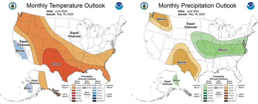
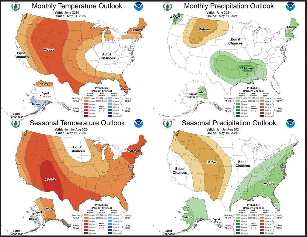
First, Let’s Take a Look at the (mid-month) Outlook for June

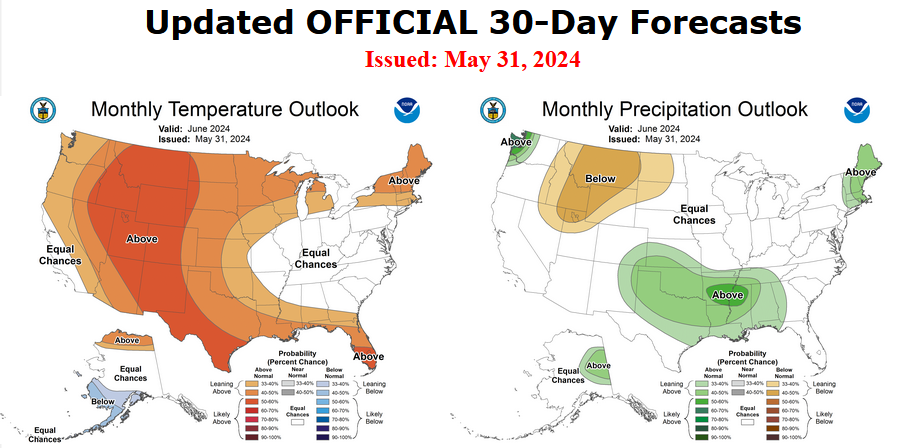
It will be updated on the last day of May.

The top row is what is now called the Mid-Month Outlook for next month which will be updated at the end of this month. There is a temperature map and a precipitation map. The second row is a three-month outlook that includes next month.  I think the outlook maps are self-explanatory. What is important to remember is that they show deviations from the current definition of normal which is the period 1991 through 2020.  So this is not a forecast of the absolute value of temperature or precipitation but the change from what is defined as normal or to use the technical term “climatology”.

Notice that the Outlook for next month and the three-month Outlook are somewhat different, especially about precipitation.  This tells us that July and August will be different than June to some extent.

The full NOAA Seasonal Outlook extends through June/July/August of 2025 (yes that is more than a year out). All of these maps are in the body of the article. Large maps are provided for June and the three-month period June/July/August.  Small maps are provided beyond that through June/July/August of 2025 with a link to get larger versions of these maps.

NOAA provides a discussion to support the maps. It is included in the body of this article. In some cases, one will need to click on “read more” to read the full article.  For those on my email list where I have sent the url of the article, that will not be necessary.

Today Through the Fourth Friday (22 to 28 days) Weather Outlook for the U.S. and a Six-Day Forecast for the World: posted May 17, 2024

This article focuses on what we are paying attention to in the next 48 to 72 hours. The article also includes weather maps for longer-term U.S. outlooks and a six-day World weather outlook which can be very useful for travelers.

First the NWS Short Range Forecast. The afternoon NWS text update can be found here but it is unlikely to have changed very much. The images in this article automatically update.

Short Range Forecast Discussion
NWS Weather Prediction Center College Park MD
Fri May 17 2024
Valid 12Z Fri May 17 2024 – 12Z Sun May 19 2024

…Potentially significant heavy rainfall threat spreads into portions of
southern Mississippi and western Alabama Friday…

…Wet start to the weekend for much of the eastern U.S. as well as the
Northern Rockies/Plains…

…Sweltering heat continues across South Florida and southern Texas into
this weekend…

A broad area of showers and thunderstorms is expected Friday across much
of the eastern U.S., with the chance for moderate to heavy rainfall likely
to focus from the Lower Great Lakes south through the Appalachians into
the Ohio/Tennessee Valleys and to the Gulf Coast. Starting along the Gulf
Coast, another day of potentially significant flash flooding is forecast
along and to the south of a warm front lifting slowly northward across the
region. A Moderate Risk of Excessive Rainfall (level 3/4) has been issued
for portions of southern Mississippi and Alabama where a complex of
organized, heavy downpour-producing storms is forecast over already
saturated soils from storms Thursday night. The location of these
additional storms will likely be influenced by the storms ongoing
overnight, bringing higher uncertainty and highlighting the importance of
remaining aware of the most current forecast. To the north, an active
series of shortwaves will help encourage a couple additional areas of
locally heavier rainfall focused over portions of the central Appalachians
as well as the Lower Ohio/Middle Mississippi Valley. Slight Risks of
Excessive Rainfall (level 2/4) are in place for both locations for the
threat of some scattered instances of flash flooding. Storm chances will
shift southeastward on Saturday, bringing the focus for moderate to heavy
rainfall to the southern Mid-Atlantic south along the coastal Carolinas
into Georgia and lingering along the central Gulf Coast. A Slight Risk of
Excessive Rainfall has been included here for portions of the central Gulf
Coast where higher available moisture is most likely to lead to locally
heavier downpours on top of already saturated conditions from the previous
days’ rainfall. Additional scattered instances of flash flooding remain
possible.

Another frontal system will bring shower and storm chances to the Northern
Rockies/High Plains early Friday and the Northern Plains/Upper-Midwest by
Friday evening. Generally light to moderate rainfall is expected, with the
more moderate rain most likely near the Red River Valley. Cooler
conditions may lead to some snow mixing in through the Northern Rockies,
though no accumulations are expected. Precipitation chances will taper off
into Saturday as the bulk of the system lifts northeastward into Canada.
However, to the southwest, some showers and storms will be possible late
Saturday into early Sunday along a trailing frontal boundary stretching
into the Central Plains.

Conditions will continue to remain unseasonably hot and very much
Summer-like for portions of South Florida and southern Texas into the
weekend. Forecast highs Friday and Saturday range from the low to mid-90s
in South Florida and the mid 90s to mid-100s in southern Texas,
potentially record-tying/breaking temperatures. High humidity will bring
heat indices into the mid- to upper-100s for many locations.
Unfortunately, this pattern looks to continue not only into next week but
into the following week as well. While not quite as hot, temperatures will
also be well-above average and Summer-like across portions of the Northern
and Central Plains Friday, with highs in the mid- to upper 80s forecast.
These temperatures will shift eastward into the Great Lakes region on
Saturday. Variable highs are expected for the rest of the central/eastern
U.S., with above average conditions into the 70s for most of the Northeast
Friday and Saturday, though portions of the Mid-Atlantic will see a cool
down into the 60s Saturday. Slightly below average conditions following a
frontal passage over the Southern Plains and Southeast will continue
Friday with highs mainly in the 70s to low 80s, though a quick warm-up
into the mid-80s to 90s will come Saturday for the Southern Plains. In the
West, conditions will be below average in the Pacific Northwest and along
coastal California, with highs mainly in the 60s. However, above average
conditions are expected into the interior, with highs in the 70s to low
80s in the Great Basin, 80s for the central California valleys, and 90s to
low 100s for the Desert Southwest.

To get your local forecast plus active alerts and warnings click HERE and enter your city, state or zip code.

Learn about wave patterns HERE.

Then, looking at the world and of course, the U.S. shows here also. Today we are looking at precipitation.

Please click on “Read More” below to access the full Daily Report issued today.

16May2024 Market Close & Major Financial Headlines: A Modest Down Day For The Markets. Industrial Production Down.

Summary Of the Markets Today:

  • The Dow closed down 38 points or 0.10%,
  • Nasdaq closed down 0.26%,
  • S&P 500 closed down 0.21%,
  • Gold $2,384 down $10.80,
  • WTI crude oil settled at $79 up $0.66,
  • 10-year U.S. Treasury 4.377% down 0.021 points,
  • USD index $104.51 up $0.17,
  • Bitcoin $63,127 up $1,675,

*Stock data, cryptocurrency, and commodity prices at the market closing.


Click here to read our current Economic Forecast – May 2024 Economic Forecast: No Real Change So Expect The Economy To Continue To Plod Along


Today’s Economic Releases Compiled by Steven Hansen, Publisher:

Job seekers’ relocating for new jobs fell to 1.5% in the final quarter of 2023, the lowest level on record as interest rates remained high and housing inventory low. However, in the first quarter of 2024, 2.4% of all job seekers relocated for new positions, and \ 3.7% of job seekers making over $200,000 moved for new jobs. Andrew Challenger, Senior Vice President and economic expert for Challenger, Gray & Christmas stated:
Currently, companies are in cost-savings mode and conducting layoffs, particularly of higher wage-earners. We’re also seeing several employers recalling workers to the office. The combination of these factors is resulting in a higher rate of workers moving for jobs.
JOB SEEKER RELOCATION RATES
Quarterly, 2018-2024

Industrial production was little changed in April 2024 with total industrial production 0.4 percentage point lower than its year-earlier level. Capacity utilization moved down to 78.4 percent in April, a rate that is 1.2 percentage points below its long-run (1972–2023) average. Industrial production component manufacturing was down 0.5% year-over-year, mining was down 1.3%, and utilities were up 2.3%. Manufacturing remains in a recession and is a drag on economic growth.

Molly Boesel from CoreLogic discussed the increasing consumer debt and how it might impact housing foreclosures:

Mortgage debt is larger, but the delinquencies on mortgages are very low right now, and they’ve remained low. But as consumers are building other debt, the delinquencies on that other debt are starting to go up. So, specifically, credit card debt and auto loan debt has been increasing.

Privately‐owned housing units authorized by building permits in April 2024 were 2.0% below April 2023. Privately‐owned housing starts were 0.6% below April 2023. Privately‐owned housing completions were 14.6% above April 2023. Housing completions are near record highs. Housing construction is a bright spot in the economy. The reason permits and starts are so low is that there is a huge backlog of housing units under construction which are tied for all time highs of 1975.

Import prices increased 1.1% year-over-year in April 2024 whilst export prices decreased 1.0% year-over-year. This is well within the 2% inflation target set by the Federal Reserve but the trend lines are upward. Following the current trend lines, within one year inflation would exceed 6% in this sector.

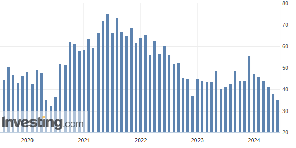
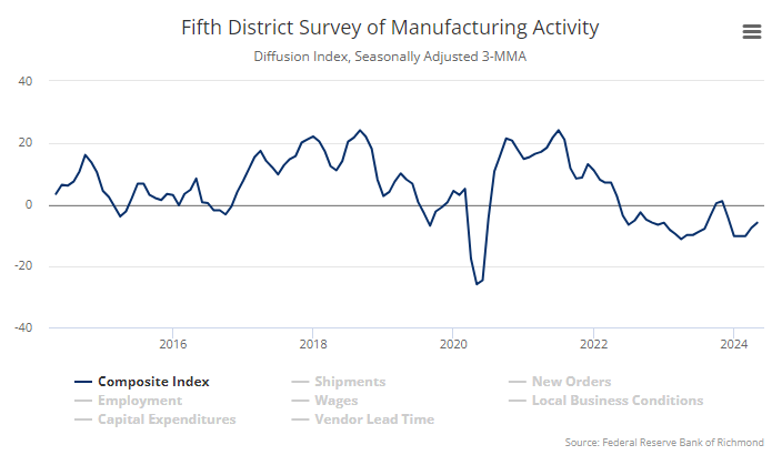
The Philly Fed Manufacturing Business Outlook Survey weakened overall. The diffusion index for current general activity remained positive but declined 11 points to 4.5 in May, mostly undoing its increase from last month. The survey’s indicators for new orders, and shipments all declined, with the latter two turning negative. The employment index suggests declines in employment overall. Both price indexes indicate overall increases in prices but remain below their long-run averages.

In the week ending May 11, the advance figure for seasonally adjusted initial unemployment claims 4-week moving average was 217,750, an increase of 2,500 from the previous week’s revised average. The previous week’s average was revised up by 250 from 215,000 to 215,250.


Here is a summary of headlines we are reading today:

  • U.S. Fast-Tracks $2 Billion Military Aid for Ukraine
  • Putin Meets With Xi Jinping As Sanctions Weigh on Russian Economy
  • Russia’s Shadow Oil Tanker Fleet Causes 50 Maritime Accidents
  • Existing Foreign Oil Producers in Venezuela May Get Licenses Despite Sanctions
  • Are High Commodity Prices Becoming a Problem for the Fed?
  • Refinery Repairs Drag Down Russia’s Oil Product Exports in April
  • Walmart surges to all-time high as earnings beat on high-income shopper, e-commerce gains
  • Walmart says more diners are buying its groceries as fast food gets pricey
  • US Spy Balloon Crashes In Northeast Syria

Click on the “Read More” below to access these, other headlines, and the associated news summaries moving the markets today.

Today Through the Fourth Friday (22 to 28 days) Weather Outlook for the U.S. and a Six-Day Forecast for the World: posted May 16, 2024

This article focuses on what we are paying attention to in the next 48 to 72 hours. The article also includes weather maps for longer-term U.S. outlooks and a six-day World weather outlook which can be very useful for travelers.

First the NWS Short Range Forecast. The afternoon NWS text update can be found here but it is unlikely to have changed very much. The images in this article automatically update.

Short Range Forecast Discussion
NWS Weather Prediction Center College Park MD
Thu May 16 2024
Valid 12Z Thu May 16 2024 – 12Z Sat May 18 2024

…Severe thunderstorms along with significant flash flooding possible
across portions of East Texas into the Gulf States through Saturday
morning…

…Unsettled weather persists across the Northeast and Central U.S today…

…Hazardous heat possible across South Florida and South Texas this week

Rain will spread across the Southern Plains and Gulf states as a hot,
moist airmass settles in across the South. This airmass will also
attribute to stint of unusually hot temperatures for South Florida and
Texas with heat indices rising above 100 degrees. Owing to the combination
of oppressive heat indices and forecast record warm overnight temperatures
in these areas, major heat-related impacts are possible with this round of
hot weather through the work week according to experimental NWS HeatRisk
guidance. The abundant moisture streaming northward as a warm front will
pool over Texas and the western/central Gulf Coast which will further
enhance rainfall efficiency and intensity as the cold front over the
Southern Plains advances eastward. Areal averages of 3 to 5 inches with
isolated higher amounts are expected to fall over areas that are already
sensitive from recent heavy rain and flooding. WPC has High Risk in effect
for portions of eastern Texas and western Louisiana today, which is a
level 4 out of 4 for significant impacts. There will likely be numerous
areas that will experience excessive rainfall and flooding. In additional
to the rainfall threat, there will also be strong to severe thunderstorms.
SPC has an Enhanced Risk in place for today with the primary threats are
large hail and damaging winds followed by a Slight Risk for Friday for the
central Gulf states. WPC had another Moderate Risk depicted over southern
Mississippi and Alabama, as the environment is ripe for continued
thunderstorm development on Friday.

Along the Eastern Seaboard, coastal low pressure located over the southern
DelMarVa will maintain locally heavy rainfall chances over Eastern Long
Island and Coastal New England through the morning hours, with 2-3″ of
rain and isolated flash flooding possible as the storm wraps up offshore.
Much of this activity in the Northeast will remain steady stratiform
rainfall, with the bulk of robust thunderstorms being confined to parts of
the Mid-Atlantic and Southeast. Across the West, most locations will have
dry and calm weather.

To get your local forecast plus active alerts and warnings click HERE and enter your city, state or zip code.

Learn about wave patterns HERE.

Then, looking at the world and of course, the U.S. shows here also. Today we are looking at precipitation.

Please click on “Read More” below to access the full Daily Report issued today.