Today Through the Fourth Friday (22 to 28 days) Weather Outlook for the U.S. and a Six-Day Forecast for the World: posted May 24, 2024

This article focuses on what we are paying attention to in the next 48 to 72 hours. The article also includes weather maps for longer-term U.S. outlooks and a six-day World weather outlook which can be very useful for travelers.

First the NWS Short Range Forecast. The afternoon NWS text update can be found here after about 4 p.m. New York time but it is unlikely to have changed very much from the morning update. The images in this article automatically update.

Short Range Forecast Discussion
NWS Weather Prediction Center College Park MD
Fri May 24 2024
Valid 12Z Fri May 24 2024 – 12Z Sun May 26 2024

…Heavy rain and severe thunderstorm chances extend from the Midwest to
the southern Plains today…

…Next round of severe weather to develop across the central/southern
Plains Saturday evening before shifting into parts of the mid-Mississippi
and Ohio valleys on Sunday…

…Dangerous and potentially record-breaking heat continues across South
Texas, the Gulf Coast, and southern Florida through Memorial Day weekend…

The relentlessly active spring weather pattern is set to continue through
the holiday weekend as two separate systems are anticipated to be
responsible for numerous showers and thunderstorms across the middle of
the Nation. An initial low pressure system deepening over the northern
Plains today, while an attached cold front extends from the Upper Midwest
to the Southern Plains, should maintain a focus for showers and
thunderstorms to develop. Additionally, cold air aloft on the backside of
the strong system could allow for snow to mix with rain across parts of
North Dakota. Along the cold front as it extends southward, storms could
turn severe from the Midwest to the southern Plains, with the greatest
potential for tornadoes across central to northern Illinois, far eastern
Iowa, and southern Wisconsin. This same cold front could slow it’s forward
progress and allow for thunderstorms to potentially train across parts of
southern Arkansas, northern Louisiana, and northeast Texas, leading to the
threat of scattered flash flooding. Elsewhere, scattered thunderstorms may
dampen outdoors plans throughout the Southeast and Tennessee Valley.

The next shortwave to eject out of the western U.S. and into the Great
Plains is expected to spark the next round of severe weather late on
Saturday in the central/southern Plains. At the surface, low pressure
forming in the lee of the central Rockies is forecast to lift a warm front
northward to the central Plains and mid-Mississippi Valley, while a sharp
dryline extends southward into the southern Plains. These features
combined with a strengthening low-level jet will allow for storms to turn
severe, containing a risk for large hail, intense rainfall rates, a few
tornadoes, and damaging wind gusts. The Storm Prediction Center has issued
an Enhanced Risk (level 3/5) for severe thunderstorms across parts of
Kansas, Oklahoma, and western Missouri in order to highlight the threat.
As clusters of storms move eastward with the system on Sunday, the flash
flooding and severe weather will shift to the mid-Mississippi and Ohio
valleys. Tornadoes, hail, strong winds, and flash flooding will be
possible. Residents and visitors located within the threat for severe
weather this weekend are urged to have multiple ways of receiving warnings
and to continue to check for the latest forecast.

Elsewhere, heat remains the main weather story along the Gulf Coast, South
Texas, and southern Florida. The hottest locations are forecast throughout
South Texas into late this weekend as highs soar above the century mark,
with heat indices up to 120 degrees possible. Temperatures into the upper
90s are anticipated to spread into much of Texas on Saturday and Sunday as
well. High heat indices will also impact the immediate Gulf Coast region
and South Florida, while also potentially breaking a few record high
temperatures. Warm overnight conditions will also provide little to no
relief for those without adequate or reliable cooling.

To get your local forecast plus active alerts and warnings click HERE and enter your city, state or zip code.

Learn about wave patterns HERE.

Then, looking at the world and of course, the U.S. shows here also. Today we are looking at precipitation.

Please click on “Read More” below to access the full Daily Report issued today.

23 May 2024 Market Close & Major Financial Headlines: Markets Gapped Up At The Opening Bell Setting New Historic Highs For The Nasdaq. At The End Of The Day, All The Three Major Indexes Closed Down With Dow Falling 600 Points For The Worst Day Of 2024

Summary Of the Markets Today:

  • The Dow closed down 606 points or 1.53%,
  • Nasdaq closed down 0.39%, (Closed at 16,732, New Historic high 16.996)
  • S&P 500 closed down 0.74, ( Closed at 5,268, New Historic high 5,342)
  • Gold $2,333 down $59.60,
  • WTI crude oil settled at $77 down $0.69,
  • 10-year U.S. Treasury 4.479 up 0.045 points,
  • USD index $105.07 up $0.140,
  • Bitcoin $66,640 down $3,097 (4.52%)

*Stock data, cryptocurrency, and commodity prices at the market closing.


Click here to read our current Economic Forecast – May 2024 Economic Forecast: No Real Change So Expect The Economy To Continue To Plod Along


Today’s Economic Releases Compiled by Steven Hansen, Publisher:

My favorite coincident indicator – the Chicago Fed National Activity Index (CFNAI) three-month moving average, increased insignificantly to –0.07 in April 2024 from –0.08 in March. The three month moving average is used for economic forecasting as the monthly data is too volatile. Twenty of the 85 individual indicators made positive contributions to the CFNAI in April, while 65 made negative contributions. Thirty indicators improved from March to April, while 54 indicators deteriorated and one was unchanged. Of the indicators that improved, 18 made negative contributions. The bottom line, which is confirmed by anecdotal data, is that the economy is running through a soft patch right now. Having said that, there is little indication that the economy is heading towards a hard landing at this point.

Sales of new single-family houses in April 2024 were 7.7% below April 2023. The median sales price of new houses sold in April 2024 was $433,500. The average sales price was $505,700. The seasonally-adjusted estimate of new houses for sale at the end of April was 480,000. This represents a supply of 9.1 months at the current sales rate. Residential sales has been a bright spot in the economy but lately sales have become more erratic – likely due to the high mortgage rates.

In the week ending May 18, the advance figure for seasonally adjusted initial unemployment claims 4-week moving average was 219,750, an increase of 1,750 from the previous week’s revised average. The previous week’s average was revised up by 250 from 217,750 to 218,000. There is no sign in the unemployment numbers of a slowing economy.

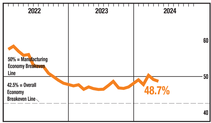
The Kansas City Fed Manufacturing Index month-over-month composite index was -2 in May 2024, up from -8 in April and -7 in March. The composite index is an average of the production, new orders, employment, supplier delivery time, and raw materials inventory indexes. The pace of decline slowed in paper, chemical, and fabricated metal manufacturing while activity expanded in printing, nonmetallic mineral, and furniture manufacturing. Manufacturing in the USA continues in a recession.

Here is a summary of headlines we are reading today:

Click on the “Read More” below to access these, other headlines, and the associated news summaries moving the markets today.

Today Through the Fourth Friday (22 to 28 days) Weather Outlook for the U.S. and a Six-Day Forecast for the World: posted May 23, 2024

This article focuses on what we are paying attention to in the next 48 to 72 hours. The article also includes weather maps for longer-term U.S. outlooks and a six-day World weather outlook which can be very useful for travelers.

First the NWS Short Range Forecast. The afternoon NWS text update can be found here after about 4 p.m. New York time but it is unlikely to have changed very much from the morning update. The images in this article automatically update.

Short Range Forecast Discussion
NWS Weather Prediction Center College Park MD
Thu May 23 2024
Valid 12Z Thu May 23 2024 – 12Z Sat May 25 2024

…Heavy rain and severe weather threats across the Arklatex region today
will expand northward across the northern and central Plains tonight…

…Heavy rain and severe weather threats will shift east into the Midwest
and remain across the Arklatex region on Friday…

…Heavy snow expected today across the higher elevations of the northern
Rockies…

As a low pressure system continues to move further away from the Great
Lakes into southeastern Canada, showers and thunderstorms ahead of the
associated cold front will push farther eastward across New England and
the Mid-Atlantic states today. Meanwhile, the trailing portion of the
front will become nearly stationary across the Mid-South where the focus
of heavy rain and severe thunderstorms will be the greatest today. These
thunderstorms may reform across the Arklatex region as the frontal
boundary meanders in the vicinity, along with the arrival of some
additional lifting mechanisms from an upper-level jet stream from the
west-southwest. The jet stream winds will tend to carry the showers and
storms downstream across the Mid-South toward the Appalachians and the
Mid-Atlantic states, keeping the weather unsettled for these areas through
the next couple of days with modest rainfall amounts although locally
heavy rain can be expected in some of the embedded thunderstorms.

Meanwhile, a rather deep and compact upper-level low from Alaska a couple
of days ago is now sweeping across the northwestern U.S. This system will
continue to usher a cold air mass through the western U.S. with a round of
heavy wet snow across the higher-elevations of Idaho, western Montana, and
into northwestern/northern Wyoming today. The energy from this system
will help develop another low pressure system across the northern and
central High Plains today. The low pressure system is forecast to further
intensify on Friday as the upper low exits into northern Plains and begins
to lift toward the northeast. Another round of showers and possibly
severe thunderstorms will develop and expand across many locations up and
down the Great Plains later today, and will begin to lift east and
northeastward into the Midwest, and along the Mississippi Valley on
Friday. A swath of cold rain is forecast across North Dakota,
southeastern Montana, and into northwestern Minnesota as the low pressure
center tracks just to the south. Temperatures could be cold enough for
some wet snow to mix in with the rain later tonight near the Canadian
border. Increasingly strong and gusty winds will also add to the chill as
the low pressure system intensifies and wraps the precipitation around the
center of circulation. By Saturday morning, the showers and storms should
progress into the Great Lakes and down across the Midwest ahead of and
near the cold/occluded fronts. Meanwhile, scattered showers and storms
will linger across the Mid-South into the Southeast where the old front
lingers.

Across southern Texas an early-season heat wave is forecast to gradually
intensify through the next few days into the Memorial Day weekend. Record
or near-record warm overnight temperatures will provide little to no
relief to those without adequate or reliable cooling. By this weekend,
record daily high temperatures and heat index readings over 115 degrees in
South Texas will also be possible. Check local media and government
websites for cooling center locations and hours, especially if you
encounter or are dealing with a loss of power. If you use a portable
generator, do so safely to avoid carbon monoxide poisoning. Never use a
generator inside a house, garage, or other enclosed space! Finally, a
critical fire danger is forecast for the southern Rockies into the
southern High Plains per the Storm Prediction Center.

To get your local forecast plus active alerts and warnings click HERE and enter your city, state or zip code.

Learn about wave patterns HERE.

Then, looking at the world and of course, the U.S. shows here also. Today we are looking at precipitation.

Please click on “Read More” below to access the full Daily Report issued today.

22 May 2024 Market Close & Major Financial Headlines: Markets Opened Fractionally Lower, Traded Sideways Across The Unchanged Line, Nasdaq Set New Historic High, Indexes Closed Moderately Lower

Summary Of the Markets Today:

  • The Dow closed down 202 points or 0.51%,
  • Nasdaq closed down 0.18%, (Closed at 16,802, New Historic high 16.855)
  • S&P 500 closed down 0.27,
  • Gold $2,381 down $46.60,
  • WTI crude oil settled at $77 down $1.34,
  • 10-year U.S. Treasury 4.422 up 0.008 points,
  • USD index $104.94 up $0.280,
  • Bitcoin $69,619 up $147 (0.21%)

*Stock data, cryptocurrency, and commodity prices at the market closing.


Click here to read our current Economic Forecast – May 2024 Economic Forecast: No Real Change So Expect The Economy To Continue To Plod Along


Today’s Economic Releases Compiled by Steven Hansen, Publisher:

The number of CEO changes at U.S. companies fell 30% to 126 in April, from 180 in March. It is down 14% from 147 CEO exits recorded in the same month last year. April’s total marks the first time in 14 months that CEO exits were lower than the corresponding month a year earlier. So far this year, 748 CEOs have announced their departures, the highest year-to-date total on record. It is up 32% from 565 exits that occurred during the same period last year, which was the previous year-to-date record. Andrew Challenger, Senior Vice President of Challenger, Gray & Christmas, Inc. stated:

The second quarter, on average, sees the fewest CEO changes, while the third quarter sees the most. This slowdown is not that surprising, given the high rate of turnover we’ve seen for the last 14 months. Leaders are navigating enormous change with the advancement of AI technology, as well as changing economic conditions, an uncertain political landscape, and burgeoning global conflicts.

Existing-home sales receded in April 2024. Total existing-home sales fell 1.9% year-over-year. Total housing inventorywas up 16.3% from one year ago. Unsold inventory sits at a 3.5-month supply at the current sales pace, up from 3.2 months in March and 3.0 months in April 2023. For homes priced $1 million or more, inventory and sales increased by 34% and 40%, respectively, from a year ago. The median existing-home price for all housing types in April was $407,600, an increase of 5.7% from the previous year ($385,800). All four U.S. regions registered price gains. NAR Chief Economist Lawrence Yun added:

Home sales changed little overall, but the upper-end market is experiencing a sizable gain due to more supply coming onto the market. Home prices reaching a record high for the month of April is very good news for homeowners. However, the pace of price increases should taper off since more housing inventory is becoming available.

LA area ports handle about 40% of the nation’s container port traffic. In April 2024, container imports are up 19% year-over-year whilst exports are up 9% year-over-year. Still, container traffic remains slightly below pre-pandemic levels – but container traffic appears to be on a slightly improving trend line.

Much time was spent discussing inflation, according to the 01May2024 Federal Open Market Committee (FOMC) meeting minutes. Highlights of the meeting minutes:

… Participants observed that while inflation had eased over the past year, in recent months there had been a lack of further progress toward the Committee’s 2 percent objective. The recent monthly data had showed significant increases in components of both goods and services price inflation. In particular, inflation for core services excluding housing had moved up in the first quarter compared with the fourth quarter of last year, and prices of core goods posted their first three-month increase in several months.

… Participants noted that they continued to expect that inflation would return to 2 percent over the medium term. However, recent data had not increased their confidence in progress toward 2 percent and, accordingly, had suggested that the disinflation process would likely take longer than previously thought. 

… Participants assessed that demand and supply in the labor market, on net, were continuing to come into better balance, though at a slower rate. 

… High interest rates appeared to weigh on consumer durables purchases in the first quarter, and growth of business fixed investment remained modest. Despite the high interest rates, residential investment grew more strongly in the first quarter than its modest pace in the second half of last year.

… Participants noted the important influence of productivity growth for the economic outlook. Some participants suggested that the recent increase in productivity growth might not persist because it reflected one-time adjustments to the level of productivity or reflected continued elevated volatility in the data over the past several years. A few participants commented that higher productivity growth might be sustained by the incorporation of technologies such as artificial intelligence into existing business operations or by high rates of new business formation in the technology sector.

… A number of participants judged that consumption growth was likely to moderate this year, as growth in labor income was expected to slow and the financial positions of many households were expected to weaken. Many participants noted signs that the finances of low- and moderate-income households were increasingly coming under pressure, which these participants saw as a downside risk to the outlook for consumption. 

… Participants discussed the risks and uncertainties around the economic outlook. They generally noted their uncertainty about the persistence of inflation and agreed that recent data had not increased their confidence that inflation was moving sustainably toward 2 percent. Some participants pointed to geopolitical events or other factors resulting in more severe supply bottlenecks or higher shipping costs, which could put upward pressure on prices and weigh on economic growth. The possibility that geopolitical events could generate commodity price increases was also seen as an upside risk to inflation. 

… participants who commented noted vulnerabilities to the financial system that they assessed warranted monitoring. Participants discussed a range of risks emanating from the banking sector, including unrealized losses on assets resulting from the rise in longer-term yields, high CRE exposure, significant reliance by some banks on uninsured deposits, cyber threats, or increased financial interconnections among banks.

Here is a summary of headlines we are reading today:

Click on the “Read More” below to access these, other headlines, and the associated news summaries moving the markets today.

Today Through the Fourth Friday (22 to 28 days) Weather Outlook for the U.S. and a Six-Day Forecast for the World: posted May 22, 2024

This article focuses on what we are paying attention to in the next 48 to 72 hours. The article also includes weather maps for longer-term U.S. outlooks and a six-day World weather outlook which can be very useful for travelers.

First the NWS Short Range Forecast. The afternoon NWS text update can be found here but it is unlikely to have changed very much. The images in this article automatically update.

Short Range Forecast Discussion
NWS Weather Prediction Center College Park MD
Wed May 22 2024
Valid 12Z Wed May 22 2024 – 12Z Fri May 24 2024

…Deep storm begins to move away from the upper Midwest/Great Lakes today
as the next heavy rain and severe weather threats emerge across the
southern Plains toward the lower to mid-Mississippi Valley tonight…

…Heavy wet snow expected to overspread the higher elevations of the
northern Rockies tonight into Thursday...

…Another rapidly developing low pressure system will bring severe
weather and heavy rain threats into the Thursday night into Friday
morning…

An active weather pattern continues from the western U.S. to the Great
Plains where unsettled and changeable weather can be expected for at least
the next couple of days. Residents across the upper Midwest into the
upper Great Lakes will wake up this morning with a rapidly intensifying
low-pressure system passing through. Much of the heavy rain and embedded
thunderstorms associated with the system are already moving into southern
Canada as the storm center continues to take a north-northeasterly track
across the western end of Lake Superior and heading quickly toward
southern Canada. Blustery winds behind the departing storm will take
extra time to subside today across the upper Midwest and the Great Lakes.
As the heavy rain and thunderstorms associated with the deep storm exit
the upper Midwest, the southern Plains will need to watch for an emerging
threat of heavy rain and severe thunderstorms where the trailing front
from the deep storm becomes nearly stationary. The most active weather
can be expected tonight as well as Thursday night from the southern Plains
toward the lower Mississippi Valley, with a lull in the activities
Thursday morning.

Meanwhile, the next energetic upper low, which had a history of diving
southeast from Alaska, is getting ready to reach the Pacific Northwest.
The system will bring a round of widespread precipitation through the
Northwest, with heavy wet snow falling across the higher elevations of
Idaho, western Montana, and into Wyoming for tonight and into Thursday.
The system will also usher a cold air mass through the Northwest by
Thursday, reaching into the northern Plains by Friday morning. Windy
conditions are also expected to overspread the entire area, especially
immediately behind a sharp cold front.

Elsewhere, relatively quiet weather is expected across the Southwest.
Meanwhile, very warm to hot weather is expected across much of the eastern
U.S. today before showers and thunderstorms quickly move into the interior
sections later today. The Mid-Atlantic states will see these showers and
embedded thunderstorms move in tonight and linger into Thursday as the
front becomes nearly stationary across the region. Additional moisture
from the South is forecast to ride along the front, bringing rounds of
showers and thunderstorms from the Mid-South to the Mid-Atlantic into
Friday morning.

Across southern Texas, the heat is forecast to gradually intensify through
the next few days, with heat indices possibly topping 110 degrees by
Thursday afternoon. Residents across southern Florida will also feel the
heat getting more oppressive as the week progresses due to gradually
increasing humidity under the influence of a high pressure ridge with fair
weather conditions.

To get your local forecast plus active alerts and warnings click HERE and enter your city, state or zip code.

Learn about wave patterns HERE.

Then, looking at the world and of course, the U.S. shows here also. Today we are looking at precipitation.

Please click on “Read More” below to access the full Daily Report issued today.

21 May 2024 Market Close & Major Financial Headlines: Indexes Opened Fractionally Lower, Then Trended Higher, Traded Mostly Sideways Just Above The Unchanged Line, Nasdaq Recorded A New High, Indexes Closed Fractionally higher

Summary Of the Markets Today:

  • The Dow closed up 66 points or 0.17%,
  • Nasdaq closed up 0.22%, (Closed at 16,833, New Historic high 16,839)
  • S&P 500 closed up 0.25%,
  • Gold $2,428 down $10.70,
  • WTI crude oil settled at $79 down $0.74,
  • 10-year U.S. Treasury 4.414 down 0.023 points,
  • USD index $104.64 up $0.07,
  • Bitcoin $69,532 down $127 (0.18%),

*Stock data, cryptocurrency, and commodity prices at the market closing.


Click here to read our current Economic Forecast – May 2024 Economic Forecast: No Real Change So Expect The Economy To Continue To Plod Along


Today’s Economic Releases Compiled by Steven Hansen, Publisher:

The Single-Family Rent Index (SFRI) shows single-family rent gains inched up again to 3.4% on an annual basis in March 2024, with the median monthly cost for a U.S. three-bedroom home at $2,052 in February. Of the 20 metro areas CoreLogic tracks, only six posted rental prices that were less expensive than the national average. Three metros in the South showed annual declines, while coastal job hubs again led for rent growth. This indicates that Americans who rent in expensive metros can shoulder the additional cost burden, thanks to higher wages in many job sectors and a U.S. unemployment rate that has remained below 4% for more than two years. Molly Boesel, principal economist for CoreLogic stated:

U.S. single-family rent growth strengthened overall in March, though some weaknesses are revealed in the latest numbers. Overbuilt areas, such as Austin, Texas continued to soften, decreasing by 3.5% annually in March. And for the first time in 14 years, single-family, attached properties posted a year-over-year decline. The continued strength in single-family detached rents indicates that potential homebuyers who are priced out of the home-purchase market are choosing to rent similar alternatives.

Here is a summary of headlines we are reading today:

Click on the “Read More” below to access these, other headlines, and the associated news summaries moving the markets today.
Today Through the Fourth Friday (22 to 28 days) Weather Outlook for the U.S. and a Six-Day Forecast for the World: posted May 21, 2024

This article focuses on what we are paying attention to in the next 48 to 72 hours. The article also includes weather maps for longer-term U.S. outlooks and a six-day World weather outlook which can be very useful for travelers.

First the NWS Short Range Forecast. The afternoon NWS text update can be found here but it is unlikely to have changed very much. The images in this article automatically update.

Short Range Forecast Discussion
NWS Weather Prediction Center College Park MD
Tue May 21 2024
Valid 12Z Tue May 21 2024 – 12Z Thu May 23 2024

…An increasing threat of severe weather and excessive rainfall as well
as high winds expected to overspread the northern Plains and upper Midwest
today through tonight and into Wednesday morning…

…Severe weather and heavy rain threat will emerge across the southern
Plains to the mid-Mississippi Valley on Wednesday…

…Cool conditions with periods of shower and high elevation snow chances
from the Rockies to the Pacific Northwest…

…Well above average temperatures across the central Plains will be
replaced by cooler conditions but summer-like weather expected to continue
across the southern Plains to the Northeast…

A persistent weather pattern will continue to send energetic and
fast-moving weather systems onshore from the Pacific Ocean into the
Northwest through the short-range forecast period. These systems will
tend to intensify as they reach into the mid-section of the country. One
such system is developing and tracking toward the northeast across the
central Plains this morning. The threat of severe weather and heavy rain
will be expanding toward the upper Midwest by tonight along with
increasingly windy conditions when the low pressure system is forecast to
become quite deep and intense. Thunderstorms that erupt ahead of a potent
cold front may contain damaging wind gusts, large hail, and a few
tornadoes, from the central Plains to the Great Lakes, and especially over
Iowa, where the Storm prediction Center has issued a Moderate Risk of
severe thunderstorms for later today. Heavy rain may also lead to
scattered instances of flash flooding through tonight across the upper
Midwest. The center of the system will begin to move into southern Canada
by Wednesday morning with the heavy rain threat quickly decreasing across
the Great Lakes but the winds will take extra time to subside there.

As the low pressure system begins to move away into southern Canada on
Wednesday, the trailing cold front will become nearly stationary across
the southern Plains where the next phase of severe weather and excessive
rainfall is forecast to emerge. It appears that these threats will expand
toward the mid-Mississippi Valley Wednesday night where thunderstorms will
tend to become slow-moving.

Meanwhile, cool and unsettled weather underneath a broad upper trough is
anticipated to remain locked-in over the Northwest and Rockies through at
least midweek. Snow is possible into the higher elevations of Wyoming and
Colorado today. Another upper trough will then bring the next round of
mountain snows and low-elevation rain into the Northwest on Wednesday
before overspreading the northern Rockies by early on Thursday where snow
levels could drop to around 7000 feet. High temperatures in these regions
are also expected to remain on the cooler side and 10 to 25 degrees below
average.

For areas south and east of the main storm system impacting the central
U.S. this week, highs are expected to soar above average and into
potentially record-breaking territory for certain spots. Widespread highs
into the 80s and low 90s are forecast from the Midwest and Deep South to
the Northeast through Wednesday, with mid-to-upper 90s and triple digits
in parts of South Texas and the southern High Plains. This heat could be
particularly dangerous for people dealing with a loss of power in parts of
Texas. Warm overnight temperatures will offer little relief and high
humidity could also lead to heat index readings over 110 degrees.

To get your local forecast plus active alerts and warnings click HERE and enter your city, state or zip code.

Learn about wave patterns HERE.

Then, looking at the world and of course, the U.S. shows here also. Today we are looking at precipitation.

Please click on “Read More” below to access the full Daily Report issued today.

20 May 2024 Market Close & Major Financial Headlines: Markets Opened Sharply Higher, Dow And Nasdaq Set New Historic Highs, Then Markets Trended Down To Close Mixed

Summary Of the Markets Today:

  • The Dow closed down 196 points or 0.49%, (Closed at 39,808, New Historic high 40.076)
  • Nasdaq closed up 0.65%, ( New Historic high 16.824)
  • S&P 500 closed up 0.09%,
  • Gold $2,433 up $15.50,
  • WTI crude oil settled at $80 down $0.32,
  • 10-year U.S. Treasury 4.443 up 0.023 points,
  • USD index $104.61 up $0.160,
  • Bitcoin $70,186 up $3,962 (5.88%), – Historic high 73,798.25

*Stock data, cryptocurrency, and commodity prices at the market closing.


Click here to read our current Economic Forecast – May 2024 Economic Forecast: No Real Change So Expect The Economy To Continue To Plod Along


Today’s Economic Releases Compiled by Steven Hansen, Publisher:

No releases today

Here is a summary of headlines we are reading today:

Click on the “Read More” below to access these, other headlines, and the associated news summaries moving the markets today.

Let’s take a look at the Weather in April 2024 in the U.S. and Globally – Posted on May 20, 2024

Much of the information in this report comes from the monthly emails I receive from John Bateman. He does public outreach for NOAA and in particular NCEI. I could find the same information and more on the NCEI website but John Bateman produces a good summary so I use it or most of it. I also add additional information from NCEI or other NOAA websites. At the end of the article, I provide links that will get you to the full reports and much additional information.


Looking at the trend for April over time.

This is the temperature trend for April in CONUS.

But look at this the most recent 25 years.  No increase but a decrease.  Data can be misleading if you do not look at it carefully

The temperature for the world, land and water hit a new record.

The temperature for the world, land only also was  a record.

The temperature for the world’s oceans also hit a record. Notice the slope is less. You can see the impact of ENSO in this graphic.

To read the rest of this article some will have to click on “Read More”.

Today Through the Fourth Friday (22 to 28 days) Weather Outlook for the U.S. and a Six-Day Forecast for the World: posted May 20, 2024

This article focuses on what we are paying attention to in the next 48 to 72 hours. The article also includes weather maps for longer-term U.S. outlooks and a six-day World weather outlook which can be very useful for travelers.

First the NWS Short Range Forecast. The afternoon NWS text update can be found here but it is unlikely to have changed very much. The images in this article automatically update.

Short Range Forecast Discussion
NWS Weather Prediction Center College Park MD
Mon May 20 2024
Valid 12Z Mon May 20 2024 – 12Z Wed May 22 2024

…Continued severe weather and excessive rainfall threats over the
central U.S. into mid-week…

…Cool conditions with periods of shower and storm chances from the
Rockies to the Pacific Northwest…

…Well above average, Summer-like temperatures to start the week across
much of the central/eastern U.S….

An energetic upper-level pattern featuring multiple shortwaves emitting
from a broader long-wave trough over the western U.S. will continue a
period of active weather over the central U.S. this week. An initial
shortwave/accompanying surface frontal system will bring showers and
thunderstorms to portions of the Upper Midwest/Great Lakes Region by early
Monday. A few more robust thunderstorms will be possible immediately ahead
of the wave over northeastern Illinois and adjacent Wisconsin/Indiana,
where the Storm Prediction Center has issued a Slight Risk of severe
weather (level 2/5) for the threat of some damaging winds and large hail.
Some locally heavy downpours and isolated flash flooding will also be
possible. Further west, lee cyclogenesis is expected over the central High
Plains as the long-wave trough further amplifies, helping to reinforce a
frontal boundary draped across the region. Moist upslope flow north of
this boundary is expected to lead to thunderstorms by Monday afternoon,
with an Enhanced Risk of severe weather (level 3/5) over northeastern
Colorado and southwestern Nebraska as some of the more robust storms may
produce very large hail, significant damaging winds, and a few tornadoes.
A broader Slight Risk extends northeastward along the front through the
central Plains into the Upper Midwest. Increasing storm coverage Monday
evening with the potential for some locally heavy downpours will also
bring the threat for some isolated flash flooding from northeastern
Colorado northeast into northwestern Iowa. Moisture spreading
northwestward into portions of the northern High Plains/Rockies will bring
moderate precipitation chances here as well, with some locally heavy
snowfall totals possible for higher mountain elevations.

Another shortwave ejecting from the longwave western trough will bring a
broader, greater chance for severe weather and flash flooding to portions
of the Midwest Tuesday. The accompanying surface low pressure/frontal
system will deepen and lift northeastward from the Plains into the Upper
Midwest, with an expansive warm sector from the Southern Plains
northeastward through the Lower Missouri and Upper Mississippi Valleys.
Both supercells and more organized convective systems are expected amidst
strengthening low and upper-level wind fields and strong instability. An
Enhanced Risk of severe weather is in place for the threat of tornadoes,
some strong, significant damaging winds, and large hail. In addition, a
deep influx of moisture as well as the strong forcing associated with the
deep surface low will help to promote heavy downpours. With more numerous
storms expected in vicinity of the surface low, a Slight Risk of Excessive
Rainfall (level 2/4) has been issued for portions of central/southern
Minnesota and northwestern Wisconsin for the risk of some scattered
instances of flash flooding. Lingering shower and thunderstorm chances
will also extend back west through the central Plains into the
central/northern Rockies.

Elsewhere, a few thunderstorms will remain possible over the Florida
Peninsula through at least Tuesday. An upper-low/frontal system dropping
southward from northwestern Canada will spread showers and storms into the
Pacific Northwest/northern Great Basin Tuesday, with some locally heavy
rainfall possible along the coastal ranges and Cascades. A broad area of
well above average temperatures is expected over much of the
central/eastern U.S. with ridging in place ahead of the trough over the
West. Highs in the 80s and even low 90s will be common, even in more
northerly locations from the Great Lakes into the Northeast. Sweltering
heat continues over portions of southern Texas into the southern High
Plains as highs soar into the 90s and 100s. In contrast, much cooler,
below average temperatures are expected to the north and west of the
system over the Plains under the influence of the western trough. Highs
from the Pacific Northwest into the Great Basin, northern/central Rockies,
and northern/central Plains will be in the 50s and 60s. Highs will be
closer to average in the Southwest with 80s and 90s forecast.

To get your local forecast plus active alerts and warnings click HERE and enter your city, state or zip code.

Learn about wave patterns HERE.

Then, looking at the world and of course, the U.S. shows here also. Today we are looking at precipitation.

Please click on “Read More” below to access the full Daily Report issued today.