Today Through the Fourth Friday (22 to 28 days) Weather Outlook for the U.S. and a Six-Day Forecast for the World: posted April 10, 2024

It is difficult to find a more comprehensive Weather Outlook anywhere else with the ability to get a local 10-day Forecast also.

This article focuses on what we are paying attention to in the next 48 to 72 hours. The article also includes weather maps for longer-term U.S. outlooks and a six-day World weather outlook which can be very useful for travelers.

First the NWS Short Range Forecast. The afternoon NWS text update can be found here but it is unlikely to have changed very much. The images in this article automatically update.

Short Range Forecast Discussion
NWS Weather Prediction Center College Park MD
400 AM EDT Wed Apr 10 2024

Valid 12Z Wed Apr 10 2024 – 12Z Fri Apr 12 2024

…Heavy rain, flash flooding and severe weather threat associated with an
intensifying low pressure system will sweep across the Arklatex region
today, reaching into the interior South tonight…

…The low pressure system will bring an expanding heavy rain and high
wind threat into much of the eastern U.S. on Thursday with severe weather
threat across the Southeast and upper Ohio Valley…

…High winds along with widespread moderate to heavy rain expected to
impact the entire Eastern Seaboard into the Great Lakes Thursday night
into Friday morning…

A low pressure system is currently consolidating over southern Texas as a
dynamic upper-level trough is getting ready to move off northern Mexico
and then vigorously interact with moisture returning from the Gulf of
Mexico. The clusters of strong to severe thunderstorms that have already
formed and impacted the western Gulf states are just a precursor of what
the system may produce later today when it is forecast to intensify
rapidly with thunderstorms erupting over the Arklatex region. These
thunderstorms are expected to contain very heavy rain, hail, high winds,
and the possibility of tornadoes across the interior South through tonight
as a potent cold front is forecast to sweep across from west to east. The
low pressure system itself is forecast to intensify, expand and track
toward the northeast for the next couple of days, with moderate to heavy
rainfall engulfing much of the eastern U.S. by Thursday. The heaviest
rainfall is expected to impact the central to eastern Gulf coast region
today through Thursday morning, with another heavy rain axis from the
Arklatex region to the Midwest following the center of the intensifying
low pressure system. The low pressure system is forecast to intensify and
expand further Thursday night into Friday morning, bringing high winds
into much of the eastern U.S. as well as the Great Lakes, Midwest and the
Ohio Valley. Thunderstorms should exit the Southeast by Friday morning as
the cold front moves off the coast. However, the Mid-Atlantic and
virtually the entire Northeast will likely be engulfed by moderate to
heavy rain along with high winds especially just ahead of the potent cold
front trailing south from the center of the intense and expanding low
pressure system.

Outside of the intensifying low pressure system, relatively quiet weather
is expected for the next couple of days with a stable upper ridging
building into the western U.S. Scattered rain and snow showers are
expected to fall across the northern Rockies and northern High Plains
today before reaching into the northern Plains as a clipper system swings
across these areas. Light precipitation is forecast to reach the Pacific
Northwest Thursday night with the arrival of the next Pacific system.
Otherwise, improvement in the fire weather threat is expected across the
southern High Plains where elevated fire danger is confined to the Texas
Big Bend today, followed by portions of the central Plains on Thursday.

To get your local forecast plus active alerts and warnings click HERE and enter your city, state or zip code.

Above is a 72 hour animation of the forecast. Learn about wave patterns HERE.

Then, looking at the world and of course, the U.S. shows here also. Today we are looking at precipitation.

Please click on “Read More” below to access the full Daily Report issued today.

09 Apr 2023 Market Close & Major Financial Headlines: After The Opening Bell The Markets Nose-Dived From Green Deeply Into The Red, Spending Most Of Today’s Session In Negative Territory Closing Mixed

Summary Of the Markets Today:

  • The Dow closed down 9 points or 0.02%,
  • Nasdaq closed up 0.32%,
  • S&P 500 closed up 0.14%,
  • Gold $2,366 up $16.90,
  • WTI crude oil settled at $85 down $1.14,
  • 10-year U.S. Treasury 4.358% down 0.062 points,
  • USD index $104.11 down $0.030,
  • Bitcoin $69,060 down $2,705 (3.76%)

*Stock data, cryptocurrency, and commodity prices at the market closing.


Click here to read our current Economic Forecast – April 2024 Economic Forecast: Economy Marginally Improving But Growth Will Be Weak


Today’s Economic Releases Compiled by Steven Hansen, Publisher:

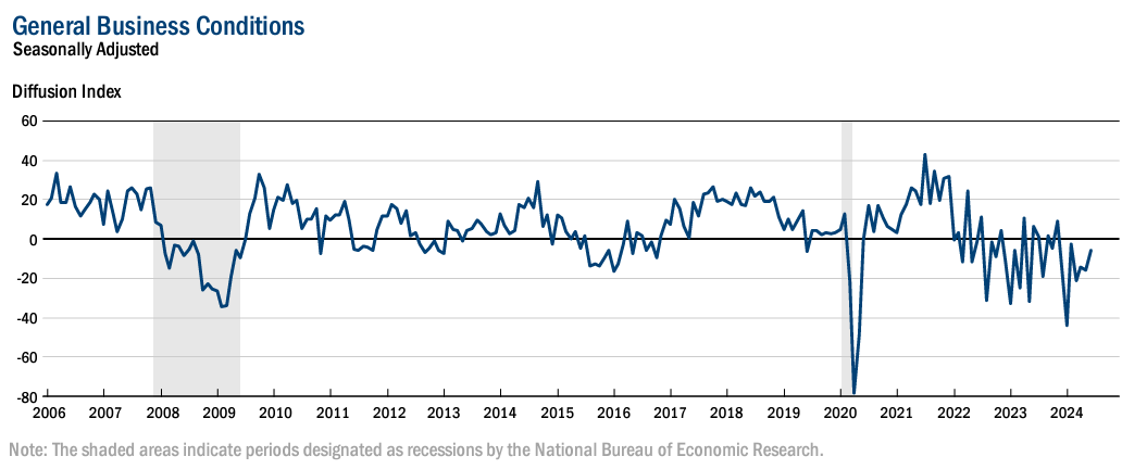
The NFIB Small Business Optimism Index decreased by 0.9 of a point in March 2024 to 88.5, the lowest level since December 2012. This is the 27th consecutive month below the 50-year average of 98. The net percent of owners raising average selling prices rose seven points from February to a net 28% percent seasonally adjusted. NFIB Chief Economist Bill Dunkelberg added:

Small business optimism has reached the lowest level since 2012 as owners continue to manage numerous economic headwind. Inflation has once again been reported as the top business problem on Main Street and the labor market has only eased slightly.

Here is a summary of headlines we are reading today:

Click on the “Read More” below to access these, other headlines, and the associated news summaries moving the markets today.

Today Through the Fourth Friday (22 to 28 days) Weather Outlook for the U.S. and a Six-Day Forecast for the World: posted April 9, 2024

It is difficult to find a more comprehensive Weather Outlook anywhere else with the ability to get a local 10-day Forecast also.

This article focuses on what we are paying attention to in the next 48 to 72 hours. The article also includes weather maps for longer-term U.S. outlooks and a six-day World weather outlook which can be very useful for travelers.

First the NWS Short Range Forecast. The afternoon NWS text update can be found here but it is unlikely to have changed very much. The images in this article automatically update.

Short Range Forecast Discussion
NWS Weather Prediction Center College Park MD
Tue Apr 09 2024
Valid 12Z Tue Apr 09 2024 – 12Z Thu Apr 11 2024

…Heavy rain, flash flooding and severe weather threat will expand across
the Southern Plains into the lower Mississippi Valley through Wednesday,
reaching into Midwest, Ohio/Tennessee Valleys and the Southeast by
Thursday morning…

…Critical fire danger shifts into Texas Big Bend and Rio Grande Valley…

Following the 2024 Great American Eclipse, a developing low pressure
system over the southern Plains will become the main weather story for the
next couple of days. A vigorous upper-level trough exiting the southern
Rockies/ northern Mexico will continue to interact with moisture returning
from the Gulf of Mexico to deliver sprawling areas of heavy rain and
embedded severe thunderstorms first across eastern Texas into the Arklatex
region today, before expanding into the Texas Panhandle tonight. The
dynamic interaction will then consolidate and intensify a low pressure
system gradually over eastern Texas tonight, before taking the system more
rapidly northeastward across the Arklatex region on Wednesday. It appears
that a potent cold front trailing south from the low center will be the
focus for strong to severe thunderstorms across eastern Texas Wednesday
morning, through the lower Mississippi Valley on Wednesday, before
reaching into the eastern Gulf states and the Florida Panhandle by early
on Thursday. Less of a severe weather threat is forecast for areas north
of the low pressure center track. Meanwhile, heavy rain could lead to
flooding concerns from the Texas Panhandle tonight, with the highest
threat across the Mid-South through Wednesday, before spreading into the
Midwest and lower Great Lakes early on Thursday. Winds will become
increasingly strong and gusty as the low pressure system becomes quite
strong by Thursday morning.

Outside of the intensifying low pressure system, relatively quiet weather
is expected for the next couple of days. The cloud cover and areas of rain
across the northern Plains into the upper Great Lakes are forecast to
taper off tonight as an old cyclone continues to fill and departs into
southern Canada. Scattered showers will then reach into the lower Great
Lakes Tuesday night, and continue to spread into New England Wednesday
night. The Pacific Northwest will see the arrival of a frontal zone with
some moisture and high elevation light snows into the northern Cascades
and eventually Rockies Tuesday before drying out on Wednesday. A warming
trend is in store for the West and East Coast, as well as the northern
tier states while cooler than normal temperatures will linger across the
South behind the intensifying low pressure system.

To get your local forecast plus active alerts and warnings click HERE and enter your city, state or zip code.

Above is a 72 hour animation of the forecast. Learn about wave patterns HERE.

Then, looking at the world and of course, the U.S. shows here also. Today we are looking at precipitation.

Please click on “Read More” below to access the full Daily Report issued today.

08 Apr 2023 Market Close & Major Financial Headlines: After The Opening Bell The Three Main Indexes Gyrated Across The Unchanged Line Before Closing Essentially Flat And Mixed

Summary Of the Markets Today:

  • The Dow closed down 11 points or 0.03%,
  • Nasdaq closed up 0.03%,
  • S&P 500 closed down 0.04%,
  • Gold $2,358 up $13.00,
  • WTI crude oil settled at $87 down $0.27,
  • 10-year U.S. Treasury 4.424% up 0.046 points,
  • USD index $104.16 down $0.140,
  • Bitcoin $71,671 up $2,392 (3.75%),

*Stock data, cryptocurrency, and commodity prices at the market closing.


Click here to read our current Economic Forecast – April 2024 Economic Forecast: Economy Marginally Improving But Growth Will Be Weak


Today’s Economic Releases Compiled by Steven Hansen, Publisher:

none today

Here is a summary of headlines we are reading today:

Click on the “Read More” below to access these, other headlines, and the associated news summaries moving the markets today.

Today Through the Fourth Friday (22 to 28 days) Weather Outlook for the U.S. and a Six-Day Forecast for the World: posted April 8, 2024

It is difficult to find a more comprehensive Weather Outlook anywhere else with the ability to get a local 10-day Forecast also.

This article focuses on what we are paying attention to in the next 48 to 72 hours. The article also includes weather maps for longer-term U.S. outlooks and a six-day World weather outlook which can be very useful for travelers.

First the NWS Short Range Forecast. The afternoon NWS text update can be found here but it is unlikely to have changed very much. The images in this article automatically update.

Short Range Forecast Discussion
NWS Weather Prediction Center College Park MD
Mon Apr 08 2024
Valid 12Z Mon Apr 08 2024 – 12Z Wed Apr 10 2024

…Northern New England remains the best location for clear viewing of the
total solar eclipse this afternoon…

…Lingering wet snow across the Northern Plains expected to taper off
later today while locally moderate rain moves across the Upper Midwest…

…Heavy rain, flash flooding and severe weather threat emerging across
the Southern Plains to the lower Mississippi Valley on Tuesday…

…Critical fire danger shifts southward into western Texas by Tuesday…

As the long-anticipated total solar eclipse scheduled to take place this
afternoon, the weather pattern across the U.S. is entering a transition
period from one that consists of a winter storm across the North to heavy
rain and severe thunderstorms across the South. The low pressure system
that has brought snow, high winds, and severe weather to various locations
across the northern and central U.S. will continue to weaken and track
northeast across the upper Midwest today, and then move into southern
Canada on Tuesday. Lingering wet snow across the Northern Plains is
expected to taper off later today while locally moderate rain moves across
the Upper Midwest.

Monday morning will feature showers and embedded thunderstorms across the
Great Lakes down into the Ohio Valley, Tennessee Valley and the lower
Mississippi Valley well in advance of the low pressure system and near the
trailing cold front. Meanwhile, moisture from the Gulf of Mexico is
beginning to return to the western Gulf states. Southern Texas will
likely wake up to fair conditions this morning but will likely followed by
a rapid untimely increase of clouds this morning into the afternoon prior
to the arrival of the solar eclipse. In contrast, northern New England
remains to be the region where cloud cover will likely be minimized along
the path of totality this afternoon as the nor’easter moves farther out
into the Atlantic. It appears that other locations in between will have a
fair chance of cloud covers at various levels, although locations across
the Midwest could see breaks in the clouds or high thin clouds during the
time of totality.

Monday night into Tuesday will likely see the threat of heavy rain
blossoming across the South from eastern Texas/eastern Oklahoma expanding
eastward into the lower Mississippi Valley in response to a potent upper
trough approaching from the southern Rockies that will interact with the
influx of Gulf moisture. A few inches of rain will likely be common from
northern Louisiana into southern Arkansas through Wednesday morning with
this setup. In addition, severe thunderstorms are also expected to
develop within the heavy rain area from Tuesday morning onward into
Wednesday morning when a low pressure system is forecast to develop over
Texas. The heaviest rains and severe storms should begin to head farther
east by Wednesday morning into the Mid-South as the low pressure system
intensifies and tracks toward the east-northeast.

Meanwhile, moisture from the next Pacific system is forecast to bring the
next round of precipitation into the Pacific Northwest by later today and
spread into the northern Rockies on Tuesday. Much of the Southwest into
the Four Corners will remain dry with some gusty winds as a dry cold front
passes through. As for fire weather, it appears that the area of Critical
Risk of Fire Weather will be confined to western Texas per the Storm
Prediction center.

Forecast high temperatures will tend to be at or above average and mild to
warm over much of the central/eastern U.S. today ahead of the system over
the Midwest/Plains. The greatest anomalies will be in the lower Great
Lakes vicinity, where temperatures into the 60s and 70s are upwards of
15-20 degrees above normal. The frontal boundary sagging southward and
increasing coverage of precipitation chances will bring cooler
temperatures from the Tennessee Valley west through the ArkLaTex and into
portions of the Southern Plains/Rockies Tuesday. Temperatures are forecast
to warm up by 10-15 degrees over the Northern Plains Tuesday following one
more chilly day on Monday. An expanding area of warm, above average
temperatures will spread inland from California into the Great Basin
Tuesday as an upper-level ridge builds in.

To get your local forecast plus active alerts and warnings click HERE and enter your city, state or zip code.

Above is a 72 hour animation of the forecast. Learn about wave patterns HERE.

Then, looking at the world and of course, the U.S. shows here also. Today we are looking at precipitation.

Please click on “Read More” below to access the full Daily Report issued today.

Today Through the Fourth Friday (22 to 28 days) Weather Outlook for the U.S. and a Six-Day Forecast for the World: posted April 7, 2024

It is difficult to find a more comprehensive Weather Outlook anywhere else with the ability to get a local 10-day Forecast also.

This article focuses on what we are paying attention to in the next 48 to 72 hours. The article also includes weather maps for longer-term U.S. outlooks and a six-day World weather outlook which can be very useful for travelers.

First the NWS Short Range Forecast. The afternoon NWS text update can be found here but it is unlikely to have changed very much. The images in this article automatically update.

Short Range Forecast Discussion
NWS Weather Prediction Center College Park MD
Sun Apr 07 2024
Valid 12Z Sun Apr 07 2024 – 12Z Tue Apr 09 2024

…Wet snow and high winds across the northern High Plains today are
expected to gradually become less intense by tonight…

…Mixed rain and wet snow spread east across the northern Plains into
tonight as showers and thunderstorms move across the Midwest, Mid-South,
Great Lakes toward the central Appalachians Monday morning…

…Threat of heavy rain quickly emerges across the western Gulf states
later on Monday and then expands further into the Mid-South by Tuesday
morning…

…Critical to Extreme Fire Weather Risk continues over portions of the
central/southern High Plains today with improvements on Monday…

An intense low pressure system, likely reaching peak intensity early this
Sunday morning, has continued to impact much of the High Plains and nearby
Rockies with winds locally gusting over hurricane force. The cold air
mass behind this intense storm is supporting wet snow across the northern
High Plains into the northern Rockies. The combination of wet snow in the
midst of the high winds has resulted in blizzard conditions locally over
western Nebraska. Meanwhile, plenty of warm air is wrapping around the
eastern side of the storm with bands of showers and thunderstorms sweeping
through the northern and central Plains. The intense storm is expected to
gradually weaken today as it moves generally toward the upper Midwest.
Mixed rain and wet snow are expected across the northern Plains by tonight
as showers and embedded thunderstorms move into the Great Lakes and down
the Mississippi Valley by early on Monday. The rain/snow over the
northern Plains is expected to taper off by Monday night when the low
pressure system weakens further and heads toward southern Canada by
Tuesday morning.

Meanwhile, the huge circulation associated with the weakening nor’easter
has been slow to exit New England, with some wet snow and rain still
affecting Maine and the Cape Cod area early Sunday morning. The
precipitation is expected to taper off this morning as the huge storm
begins to move out into the Atlantic. Colder air wrapping around the huge
storm will lead to below freezing temperatures as far south as the
southern Appalachians early this morning before the April sun and the
arrival warm air from the intense storm over the Plains send temperatures
well up into the 60s to near 70 by this afternoon.

For the total solar eclipse that is scheduled to take place on Monday, it
appears that southern Texas will wake up to considerable clouds Monday
morning with a resurgence of warm and moist air from the Gulf of Mexico.
In contrast, New England will likely wake up to clearing skies with cold
temperatures into the 20s Monday morning under a fresh snow cover from the
recent nor’easter. There will probably be some breaks in the clouds from
northern Arkansas to central Ohio behind a front, and mostly cloudy
farther northeast from eastern Ohio to western portions of New York.

Beginning late on Monday into Tuesday, a threat of heavy rain will quickly
emerge across the western Gulf states and then expands further into the
Mid-South in response to a return of Gulf moisture which will then
interact with an upper trough arriving from the southern Rockies. In
contrast, very dry conditions combined with strong downslope winds from
the Rockies will keep fire danger at critical to locally extreme levels
across the central to southern High Plains with some improvements on
Monday. Meanwhile, moisture from the next Pacific system is forecast to
bring the next round of precipitation into the Pacific Northwest by later
on Monday into Tuesday.

To get your local forecast plus active alerts and warnings click HERE and enter your city, state or zip code.

Above is a 72 hour animation of the forecast. Learn about wave patterns HERE.

Then, looking at the world and of course, the U.S. shows here also. Today we are looking at precipitation.

Please click on “Read More” below to access the full Daily Report issued today.

Federal Deficit Spending (Quarterly) and Inflation. Part 1

We have found that the correlation relationships between various types of credit and inflation are variable over time.  So far, the kinds of credit studied are government spending,1 consumer credit,2 mortgage debt,3 nonfinancial corporate credit,4 and financial sector debt.5 Here, we return to federal deficit spending and inflation by analyzing data organized differently than previously used.


The Treasury Department Building in Washington DC. (Public domain, Wikipedia.)

NOAA Sees No Sign of Greenhouse Gases Increases Slowing in 2023 – Posted April 6, 2024

Not a surprise but worth keeping track of and it is an interesting summary. I have published Theo Stein’s post in full and added some of my comments in boxes below some of the graphs and I added a paragraph explaining the Keeling Curve.


Some may need to click on “Read More” to read the rest of this interesting article

Today Through the Fourth Friday (22 to 28 days) Weather Outlook for the U.S. and a Six-Day Forecast for the World: posted April 6, 2024

It is difficult to find a more comprehensive Weather Outlook anywhere else with the ability to get a local 10-day Forecast also.

This article focuses on what we are paying attention to in the next 48 to 72 hours. The article also includes weather maps for longer-term U.S. outlooks and a six-day World weather outlook which can be very useful for travelers.

First the NWS Short Range Forecast. The afternoon NWS text update can be found here but it is unlikely to have changed very much. The images in this article automatically update.

Short Range Forecast Discussion
NWS Weather Prediction Center College Park MD
Sat Apr 06 2024
Valid 12Z Sat Apr 06 2024 – 12Z Mon Apr 08 2024

…Winter Storm to develop over the northern High Plains and nearby
foothills of the Rockies with high winds possible later today into
Sunday…

…Severe thunderstorms possible later today across the central Plains,
shifting toward the Mississippi Valley on Sunday…

…High winds will impact much of the High Plains today, reaching into the
Great Plains on Sunday…

…Critical Fire Weather Risk continues over Central/Southern High
Plains…

…Warm weekend ahead for Central U.S.; East and West Coasts remain below
average…

A low pressure system currently intensifying over the central High Plains
will be the focus of high winds, severe thunderstorms, and snow across the
mid-section of the country for the remainder of the weekend. The
highly-amplified upper trough that has ushered a fresh dose of cold air
into much of the western U.S. will continue to support mountain snow today
from the Great Basin to the Four Corners and up across the northern and
central Rockies. Meanwhile, the tight pressure gradient ahead of a potent
cold front will bring high winds across much of the central and southern
High Plains today. As the low pressure system intensifies further over
the central High Plains, the focus of the snow will gradually lift toward
the northern High Plains by tonight ahead of a nearly stationary front.
The snow is expected to become heavy from near the foothills of the
northern Rockies to the northern High Plains later today and into Sunday.
Anywhere between 6-12 inches of snow is possible with 1-2 feet more likely
at higher elevations (Big Horns, Shirley, Laramie Mountains). The winds
just behind the intense low pressure center will likely become very strong
and gusty, possibly resulting in blizzard conditions in these areas. The
strongest winds could occur near the foothills of northern Colorado where
winds could be damaging at times from Saturday night into early Sunday.
Farther south, the persistently dry downslope winds from the Rockies will
keep fire danger from critical to locally extreme levels across the
central to southern High Plains through the next couple of days.

On the warm side of the system, severe thunderstorms are possible ahead of
the intensifying low pressure system and the associated potent cold front
across the central Plains, mainly later today and into early on Sunday.
Sunday night should see the heavy snow and high winds to begin winding
down across the northern High Plains as the low pressure system weakens
and slowly moves farther to the east. Showers and thunderstorms are
expected to expand farther east into the upper Midwest and farther south
into the Mississippi Valley along the cold front.

Meanwhile, more snow showers are expected to continue today from the
central Appalachians up through the lower Great Lakes and interior
Northeast/New England as the circulation of a huge nor’easter will be slow
to exit into the Atlantic. An additional few inches of new snow with
locally up to 6 inches is possible across northern New England today
before sunshine returns on Sunday. High temperatures will remain below
average along the East Coast into Monday morning thanks to the cloudiness.
Meanhwile, a pronounced ridge will support warmer than average
temperatures across the Great Plains and Mississippi Valley this weekend.
In contrast, northern New England will wake up to temperatures in the 20s
Monday morning with clearing skies while southern Texas will be under
considerable cloudiness prior to the total solar eclipse.

To get your local forecast plus active alerts and warnings click HERE and enter your city, state or zip code.

Above is a 72 hour animation of the forecast. Learn about wave patterns HERE.

Then, looking at the world and of course, the U.S. shows here also. Today we are looking at precipitation.

Please click on “Read More” below to access the full Daily Report issued today.

05 Apr 2023 Market Close & Major Financial Headlines: Markets Gapped Up At The Opening Bell, Then Continued To Trend Higher, Closing Moderately Higher In The Green

Summary Of the Markets Today:

  • The Dow closed up 307 points or 0.80%,
  • Nasdaq closed up 1.24%,
  • S&P 500 closed up 1.11%, ( New high 5,265)
  • Gold $2,342 up $33.20,
  • WTI crude oil settled at $87 up $0.16,
  • 10-year U.S. Treasury 4.392% up 0.083 points,
  • USD index $104.30 up $0.180,
  • Bitcoin $67,356 down $1,404 (2.00%), – Historic high 73,798.25
  • Baker Hughes Rig Count: U.S. -1 to 620

*Stock data, cryptocurrency, and commodity prices at the market closing.


Click here to read our current Economic Forecast – April 2024 Economic Forecast: Economy Marginally Improving But Growth Will Be Weak


Today’s Economic Releases Compiled by Steven Hansen, Publisher:

Total nonfarm payroll employment rose by 303,000 in March 2024, and the unemployment rate changed little at 3.8 percent. Significant job gains occurred in health care, government, and construction. The household survey shows 498,000 jobs were added whilst the headline establishment survey shows 303,000 – this begins to lessen the employment gap between the household and establishment surveys which had been growing. And the household survey which is used for the headline unemployment rate added 469,000 people to the labor force [normally this would have caused the unemployment rate to grow but had little effect this month]. This is a very strong jobs report, and works against any reduction in the federal funds rate as the economy is heating up. In the graph below, the establish survey’s job gains are the blue bars whilst the establishment survey is the red bars.

Here is a summary of headlines we are reading today:

Click on the “Read More” below to access these, other headlines, and the associated news summaries moving the markets today.