The State of Joe Sixpack in 2Q2024: Most Households Are Worse Off Than They Were One Year Ago

Written by Steven Hansen

The Federal Reserve data release (Z.1 Flow of Funds) – which provides insight into the finances of the average household – shows most Americans are worse off in the second quarter of 2024 than they were in the first quarter – and also are worse off than they were one year ago. This is notwithstanding that their average net worth increased from $152,985 one year ago to $163,797 in 2Q 2024.

Today Through the Fourth Friday (22 to 28 days) Weather Outlook for the U.S. and a Six-Day Forecast for the World: posted September 15, 2024

This article focuses on what we are paying attention to in the next 48 to 72 hours. The article also includes weather maps for longer-term U.S. outlooks and a six-day World weather outlook which can be very useful for travelers.

First the NWS Short Range Forecast. The afternoon NWS text update can be found here after about 4 p.m. New York time but it is unlikely to have changed very much from the morning update. The images in this article automatically update.

Short Range Forecast Discussion
NWS Weather Prediction Center College Park MD
Sun Sep 15 2024
Valid 12Z Sun Sep 15 2024 – 12Z Tue Sep 17 2024

…Heavy rain/flash flood threat continues today for portions of the Lower
Mississippi Valley and Southeast…

…A coastal storm will bring wind and rain to the Carolinas and
Mid-Atlantic over the next few days…

…A strong low pressure system will bring unsettled weather and well
below normal temperatures to the West with high-elevation snow in the
Sierra Nevada…

Francine’s remnants will linger over the southeastern U.S. early this week
as a nearly stationary frontal boundary sags south to the Gulf Coast.
Chances for locally heavy rain and isolated to scattered instances of
flash flooding will continue today for portions of the Lower Mississippi
Valley and Southeast. There is a Slight Risk of Excessive Rainfall (level
2/4) for parts of Mississippi, Alabama, and the Florida panhandle where
flooding will be most likely. Chances for showers and storms will persist
across this region over the next few days, but the risk of flooding will
gradually decrease, with only isolated flooding concerns expected Monday
and Tuesday.

Meanwhile, a separate area of low pressure will strengthen off the
Southeast Coast and gradually move north towards the Carolinas. This
system is likely to bring gusty winds, heavy rain, coastal flooding, and
dangerous beach conditions to the Carolinas and portions of the
Mid-Atlantic through mid-week. Strong high pressure over the Northeast
will slow the forward motion of this system, increasing the chance of
heavy rainfall totals and flash flooding. There is a Slight Risk of
Excessive Rainfall (level 2/4) for portions of the eastern Carolinas and
far southeastern Virginia with an embedded Moderate Risk (level 3/4) over
southeastern North Carolina where the risk of flash flooding will be
highest. The National Hurricane Center is also monitoring this system for
potential subtropical or tropical development, and has marked this area
with a 50% chance of tropical formation over the next 48 hours. There is
still quite a bit of uncertainty on the timing, intensity, and track of
this system, so regularly check for forecast updates over the next couple
of days.

In the West, an unsettled pattern is beginning to take root as upper level
troughing moves into the region. A deep upper low will move over the West
Coast today and Monday and push across the Intermountain West to the
Rockies on Tuesday. This will push a strong frontal system across the West
that will bring widespread precipitation chances and much cooler
temperatures to the region over the next few days. Precipitation will
mainly fall as rain, but temperatures will be cold enough in the high
elevations of the Sierra Nevada for some early season snow. A Winter
Weather Advisory is in effect for portions of the Sierra Nevada above 8000
feet where up to 4 inches of snow may fall tonight and Monday.
Precipitation chances will also increase across the Southwest/Four Corners
region today as tropical moisture streams north from Tropical Cyclone
Ileana, which will support monsoon-like showers and thunderstorms through
Tuesday.

Temperatures will have a large range across the United States over the
next few days. Forecast precipitation and cloud cover will keep
temperatures slightly below normal across the Southeast and Mid-Atlantic,
with highs from the mid 70s to the mid 80s. Well above average
temperatures are forecast for the Central U.S. and Northeast, with the
highest anomalies forecast to develop under high pressure in the Upper
Midwest/Great Lakes region. High temperatures will reach the 80s and 90s,
which will be 10-20 degrees above normal for some areas. Well below
average temperatures are forecast to spread across the West through
Tuesday under the deep upper low/trough, and high temperatures will be as
low as 15-25 degrees below normal. The coldest anomalies will be in
Oregon, Nevada, and California on Monday. Highs in the 50s will be common
in the Great Basin, and highs will likely only reach the 30s and 40s in
the Sierra Nevada.

To get your local forecast plus active alerts and warnings click HERE and enter your city, state or zip code.

Learn about wave patterns HERE.

Then, looking at the world and of course, the U.S. shows here also. Today we are looking at precipitation.

Please click on “Read More” below to access the full Daily Report issued today.

NOAA Updates its ENSO Alert on September 12, 2024 – We Remain in ENSO Neutral – Published September 14, 2024

“Synopsis: ” A weaker La Niña implies that it would be less likely to result in conventional winter impacts, though predictable signals could still influence the forecast guidance”  

So we are really in ENSO Neutral but NOAA may not want to admit their forecast was wrong so they present it as waiting for La Nina. It is correct that we are in La Nina Watch but it is also correct that we currently remain in ENSO Neutral.

On the second Thursday of every month, NOAA (really their Climate Prediction Center CPC) issues its analysis of the status of ENSO. This includes determining the Alert System Status.  NOAA now describes their conclusion as “ENSO Alert System Status: La Nino Watch”

The exact timing of the transition is now perhaps more clear which should increase the reliability of the Seasonal Outlook to be issued next Thursday.

We have included an ENSO Blog article by Emily  Becker.

CLIMATE PREDICTION CENTER ENSO DISCUSSION (LINK)


The second paragraph is what is important:

“The IRI plume predicts a weak and a short duration La Niña, as indicated by the Niño-3.4 index values less than -0.5°C (Fig. 6).  This month, the team relies more on the latest North American Multi-Model Ensemble (NMME) guidance, which predicts La Niña to emerge in the next couple of months and continue through the Northern Hemisphere winter.  The continuation of negative subsurface temperatures and enhanced low-level easterly wind anomalies supports the formation of a weak La Niña.  A weaker La Niña implies that it would be less likely to result in conventional winter impacts, though predictable signals could still influence the forecast guidance (e.g., CPC’s seasonal outlooks).  In summary, La Niña is favored to emerge in September-November (71% chance) and is expected to persist through January-March 2025 (Fig. 7).”

Below is the middle paragraph from the discussion last month.

“The IRI plume indicates that Niño-3.4 is most likely to be below La Niña thresholds for four overlapping seasons, from September-November 2024 through December 2024 – February 2025.  Based on updated guidance and recent observations, the forecast team predicts nearly equal chances for ENSO-neutral and La Niña in August-October 2024, with higher odds for La Niña in September-November. Although the rate of SST cooling has been slower than previously anticipated, below-average subsurface temperatures and low-level easterly wind anomalies remain conducive to La Niña development in the coming months.  In summary, ENSO-neutral is expected to continue for the next several months, with La Niña favored to emerge during September-November (66% chance) and persist through the Northern Hemisphere winter 2024-25 (74% chance during November-January). “

We now provide additional details.

CPC Probability Distribution

Here are the new forecast probabilities. The probabilities are for three-month periods e.g. ASO  stands for August/September/October.

Here is the forecast from last month.

The analysis this month and last month are a bit different with again the transition to La Nina being slightly slower than thought last month. This seems to be a trend. The chart is clearer than the discussion in the summary report above.  The La Nina is aa bit slower to arrive. I am not sure that we will actually have a La Nina.

Some will need to click on “Read More” to read the rest of this article.

Today Through the Fourth Friday (22 to 28 days) Weather Outlook for the U.S. and a Six-Day Forecast for the World: posted September 14, 2024

This article focuses on what we are paying attention to in the next 48 to 72 hours. The article also includes weather maps for longer-term U.S. outlooks and a six-day World weather outlook which can be very useful for travelers.

First the NWS Short Range Forecast. The afternoon NWS text update can be found here after about 4 p.m. New York time but it is unlikely to have changed very much from the morning update. The images in this article automatically update.

Short Range Forecast Discussion
NWS Weather Prediction Center College Park MD
Sat Sep 14 2024
Valid 12Z Sat Sep 14 2024 – 12Z Mon Sep 16 2024

…Heavy rain and flash flood threat will continue for portions of the
Southeast this weekend, then the flash flood threat will shift to the
Carolinas/Mid-Atlantic early next week…

…A strong low pressure system will bring unsettled weather to the West
late this weekend/early next week, with wintry precipitation expected at
high elevations…

…Well above average temperatures for the Central U.S. and Northeast;
well below average temperatures for the West…

Though it is now post-tropical, Francine will continue to bring a threat
for heavy rain and flash flooding to portions of the Southeast through
Sunday. The central area of low pressure will gradually sink south towards
the Gulf Coast with a stationary boundary extending to the Southeast Coast
and a cold front extending back towards the Southern Plains. The
stationary boundary will be the main focus for convection this weekend,
and training showers and thunderstorms with locally heavy rainfall will
create a threat for scattered instances of flash flooding. There is a
Slight Risk of Excessive Rainfall (level 2/4) for portions of Arkansas,
Tennessee, Mississippi, Alabama, and Georgia today and Sunday. Flash Flood
Watches are in effect for much of this area, and urban/poor drainage areas
and areas that already received heavy rainfall over the past few days will
be most at risk for flash flooding.

A separate area of low pressure will strengthen along the stationary
boundary extending from the Southeast Coast, which will maintain shower
and thunderstorm chances from Florida to the Carolinas and southern
Mid-Atlantic through early next week. This low pressure system is forecast
to gradually track north along the East Coast early next week and will
bring a heavy rain and flash flood threat to portions of the Carolinas and
Mid-Atlantic. There is a Slight Risk of Excessive Rainfall (level 2/4) for
eastern North Carolina on Monday where scattered instances of flash
flooding will be possible.

In the West, an unsettled pattern is forecast to develop this weekend as a
strong upper low pushes a frontal system across the region. The system
will nudge into the Pacific Northwest today, then move across northern
California, the Great Basin, and the northern Rockies Sunday and Monday.
Widespread showers and thunderstorms will accompany this system, and there
is a broad Marginal Risk of Excessive Rainfall (level 1/4) in effect for
portions of the Northern Rockies and Great Basin on Monday. This system
will also usher in well below normal temperatures, which will allow for
wintry precipitation to fall at higher elevations. A Winter Weather
Advisory is already in effect for portions of the Sierra Nevada where up
to 4 inches of snow may fall Sunday night and Monday. Precipitation
chances will also increase across the Southwest/Four Corners region late
this weekend into early next week as tropical moisture streams north ahead
of Tropical Cyclone Ileana.

Temperatures this weekend will have a large range across the United States
with well above average temperatures in the Central U.S. and Northeast and
well below average temperatures under the strong upper low in the West.
High temperatures will be in the 80s and 90s for the Central U.S. and
Northeast through Monday, which is more than 15 degrees above average for
some areas in the Upper Midwest/Great Lakes. High temperatures in the West
will be near to slightly below average today, then drop to 15 to 25
degrees below average in Oregon, California, and Nevada by Monday. Highs
in the 50s will be common in the Great Basin, and highs will likely only
reach the 30s and 40s in the Sierra Nevada.

To get your local forecast plus active alerts and warnings click HERE and enter your city, state or zip code.

Learn about wave patterns HERE.

Then, looking at the world and of course, the U.S. shows here also. Today we are looking at precipitation.

Please click on “Read More” below to access the full Daily Report issued today.

13 SEPT 2024 Market Close & Major Financial Headlines: Wall Street Market’s Opened Fractionally Higher, Trended Upward, Closing Moderately Higher

Summary Of the Markets Today:

  • The Dow closed up 297 points or 0.72%,
  • Nasdaq closed up 0.65%,
  • S&P 500 closed up 0.54%,
  • Gold $2,610 up $29.70,
  • WTI crude oil settled at $69 up $0.21,
  • 10-year U.S. Treasury 3.659 down 0.021 points,
  • USD index $101.11 down $0.26,
  • Bitcoin $59,743 up $1,617 or 2.78%,
  • Baker Hughes Rig Count: U.S. +8 to 590 Canada -2 to 218

*Stock data, cryptocurrency, and commodity prices at the market closing

Today’s Highlights

U.S. stocks rallied on Friday, capping off a strong week of gains as investors increasingly bet on a larger interest rate cut from the Federal Reserve. For the week, the Nasdaq surged over 5%, marking its best week of the year. The S&P 500 increased 4% The Dow Jones added 2%

Traders are now pricing in a 49% chance of a 50 basis point rate cut at the Fed’s upcoming meeting, up from just 15% a day earlier. This sudden shift in expectations has fueled the market’s upward momentum. However, some analysts caution that a 50 basis point cut could signal economic concerns, potentially introducing volatility into the markets.

Tech stocks, which struggled earlier in the summer, have been leading the market’s gains this week. Treasury yields eased ahead of the Fed meeting, providing additional support for stocks.

Oracle climbed 2%, capping a strong week with a potential 16% gain, its best performance in over two decades. RH, the home-furnishings company, jumped 22.6% after reporting better-than-expected quarterly results. Uber rose 6.8% following an announcement about autonomous ride-hailing expansion.


Click here to read our current Economic Forecast – September 2024 Economic Forecast: One Recession Flag Removed With Three Remaining


Today’s Economic Releases Compiled by Steven Hansen, Publisher:

US import prices increased 0.8% year-over-year (down from 1.7% last month) while export prices decreased 0.7% year-over-year (down from 1.2% last month). What will be interesting is next month’s data as the US dollar index has devalued 1.5% this month so far (September 2024).

Here is a summary of headlines we are reading today:

  • Next-Gen Nuclear Power: Oracle’s Solution for Energy-Hungry AI
  • U.S. Oil and Gas Rig Count Jumps
  • Macquarie Sees “Heavy Surplus” for Oil in 2025, Cuts Oil Price Forecast
  • An End To a Four-Week Losing Streak for Oil?
  • Boeing warns strike will ‘jeopardize’ recovery, hurt aircraft production
  • S&P 500 and Nasdaq rally Friday to cap best week in 2024: Live updates
  • Tesla Semi fire in California took 50,000 gallons of water to extinguish
  • Bitcoin nears $60,000 as consumer sentiment hits four-month high: CNBC Crypto World
  • Mortgage rates are dropping, but homes aren’t expected to get cheaper—here’s why
  • OpenAI Says Latest o1 Model On “New Level”, Can “Think Before It Answers”
  • New US shipping rules target China’s Shein and Temu
  • 2-year Treasury yield ends at lowest since September 2022 as traders weigh chance of big Fed rate cut

Click on the “Read More” below to access these, other headlines, and the associated news summaries moving the markets today.

Today Through the Fourth Friday (22 to 28 days) Weather Outlook for the U.S. and a Six-Day Forecast for the World: posted September 13, 2024

This article focuses on what we are paying attention to in the next 48 to 72 hours. The article also includes weather maps for longer-term U.S. outlooks and a six-day World weather outlook which can be very useful for travelers.

First the NWS Short Range Forecast. The afternoon NWS text update can be found here after about 4 p.m. New York time but it is unlikely to have changed very much from the morning update. The images in this article automatically update.

Short Range Forecast Discussion
NWS Weather Prediction Center College Park MD
Fri Sep 13 2024
Valid 12Z Fri Sep 13 2024 – 12Z Sun Sep 15 2024

…Francine will continue to weaken while bringing a heavy rain and flash
flood threat to the Southeast over the next couple days…

…Above average temperatures will develop across the Central U.S. and
Northeast while below normal temperatures persist in the Southeast and
West…

Francine will continue to weaken today as its low pressure center meanders
east across northern Arkansas. A stationary boundary extending from the
occluded system will remain parked across the Southeast and provide a
focus for showers and thunderstorms through Saturday. The storm’s slow
motion will result in multiple days of heavy rain for the Southeast, which
will create a flash flooding risk. There is a Slight Risk of Excessive
Rainfall (level 2/4) today from western Tennessee through northern and
central Alabama to central/southern Georgia, with an embedded Moderate
Risk (level 3/4) for portions of northern and central Alabama. Flooding
will be most likely in urban and poor drainage areas and areas that
receive training/repeat convection, and locally considerable flash
flooding may be possible, especially where soils are already saturated
from previous rainfall. The flash flood threat will continue for these
areas on Saturday with another Slight Risk (level 2/4). Flood Watches are
in effect for much of the risk area. If you encounter flooding, turn
around, don’t drown. It is never safe to walk or drive into flood waters,
and most flood fatalities occur in vehicles. Isolated severe thunderstorms
will also be possible for parts of the Southeast today where the Storm
Prediction Center has issues a Marginal Risk of Severe Thunderstorms
(level 1/5). Severe storm hazards may include a few tornadoes or severe
wind gusts.

The flash flood and severe weather threats associated with Francine will
gradually decease through the weekend, and the remnants will begin moving
south Saturday night and stall along the Gulf Coast on Sunday. Another
area of low pressure is forecast to form along the stalled frontal
boundary off the Southeast Coast, which will create stormy weather from
Florida through the eastern Carolinas through this weekend into early next
week.

In the north, an occluded low pressure system north of Montana will push
further into Canada today and Saturday and will bring a weak cold front
across the northern and central Plains. Precipitation will linger on the
backside of the low in the northern Rockies and northern High Plains this
morning, and cold air will allow for snow and mixed wintry precipitation
at higher elevations. Shower and thunderstorm chances will accompany the
weak cold front through Saturday. Strong high pressure over the Northeast
will prevent the front from making significant eastward progress, and the
front will weaken and dissipate on Sunday.

In the West, a stronger Pacific frontal system will approach the coast
later today and move inland over the weekend. Precipitation chances will
begin in the Northwest late tonight/early Saturday and spread across the
Great Basin and northern California Sunday into Monday. Precipitation
chances will also increase across portions of the Southwest on Sunday as
tropical moisture from Ileana spreads north.

Temperatures will be on the rise this weekend across the Central U.S. and
Northeast, with high temperatures forecast to reach values as high as
10-15 degrees above normal for this time of year. Highs in the 80s and 90s
will be common for the Plains, Upper Midwest/Great Lakes, and Northeast.
Precipitation and cloud cover from Francine will keep temperatures below
average for much of the Southeast. Temperatures across much of the West
will be near to slightly below average through Saturday. On Sunday, the
Pacific frontal system will usher in cooler, unsettled weather, and
temperatures will drop to well below normal along the West Coast.

To get your local forecast plus active alerts and warnings click HERE and enter your city, state or zip code.

Learn about wave patterns HERE.

Then, looking at the world and of course, the U.S. shows here also. Today we are looking at precipitation.

Please click on “Read More” below to access the full Daily Report issued today.

12 SEPT 2024 Market Close & Major Financial Headlines: Wall Street Market’s Began Today’s Session Fractionally Lower, But Trended Upwards Closing Moderately Higher In The Green

Summary Of the Markets Today:

  • The Dow closed up 235 points or 0.58%,
  • Nasdaq closed up 1.00%,
  • S&P 500 closed up 0.75%,
  • Gold $2,586 up $43.80,
  • WTI crude oil settled at $69 up $1.92,
  • 10-year U.S. Treasury 3.687 up 0.034 points,
  • USD index $101.28 down $0.40,
  • Bitcoin $57,730 up $126 or 0.22%,

*Stock data, cryptocurrency, and commodity prices at the market closing

Today’s Highlights

[Publisher note: This section highlights what the markets’ believe – and much of it is opinion and may be contradicted by our review of market releases.] U.S. stocks rose on Thursday as investors processed new inflation and labor data ahead of the Federal Reserve’s upcoming interest rate decision. The August Producer Price Index (PPI) data released on Thursday indicated easing inflationary pressures. Additionally, initial jobless claims climbed more than anticipated, reaching 230,000 last week, an increase of 2,000 from the previous week. These reports led traders to increase their odds of a 25 basis point rate cut to 87%, up from 50% just days earlier. The market’s reaction suggests that investors are now leaning towards expectations of a smaller, quarter-point interest rate cut from the Federal Reserve next week, rather than a larger half-point reduction. This shift in sentiment follows the release of consumer price data on Wednesday, which showed gradual cooling of inflation. In the corporate sector, Moderna’s shares fell by 12% after the company lowered its annual revenue outlook for 2025 and announced plans to reduce its research and development budget. Meanwhile, tech stocks led the market gains, with companies like Nvidia and Meta each rising by approximately 2%.


Click here to read our current Economic Forecast – September 2024 Economic Forecast: One Recession Flag Removed With Three Remaining


Today’s Economic Releases Compiled by Steven Hansen, Publisher:

In the week ending September 7, the advance figure for seasonally adjusted initial unemployment claims 4-week moving average was 230,750, an increase of 500 from the previous week’s revised average. The previous week’s average was revised up by 250 from 230,000 to 230,250.

According to CoreLogic, home prices nationwide, including distressed sales, increased year over year by 4.3% in July 2024. The CoreLogic HPI Forecast indicates that home prices will rise by 2.2% on a year-over-year basis from July 2024 to July 2025.

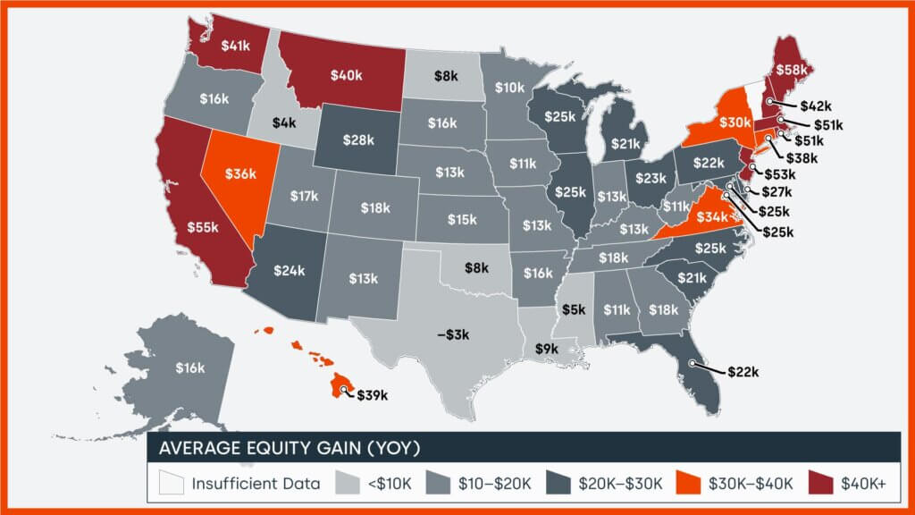
CoreLogic’s Homeowner Equity Report (HER) for the second quarter of 2024 shows that U.S. homeowners with mortgages (which account for roughly 62% of all properties) saw home equity increase by 8.0% year over year.

The Producer Price Index for final demand increased  1.7% for the 12 months ended in August 2024 (down from 2.1% for the previous month). What is going on is that the prices for oil have decreased significantly year-over-year which is evident when one removes food, energy, and trade – which shows the year-over-year inflation rate has remained steady around 3.3% year-over-year. The Federal Reserve generally removes food and energy when they look at inflation pressures – and the current situation shows inflation pressures are not subsiding but remaining steady.


Here is a summary of headlines we are reading today:

  • How Falling Oil Prices Could Save The Economy
  • Nippon Steel’s Investment Could Revitalize U.S. Steel Industry
  • Why Goldman Sachs is Still Bearish on Lithium
  • Florida LNG Export Project Delayed Five Years Due to Supply Chain Issues
  • Europe’s LNG Ambitions Face Reality Check
  • U.S. Gasoline Prices Set to Drop Below $3 Before Election Day
  • Here’s the deflation breakdown for August 2024 — in one chart
  • Dow closes 200 points higher, S&P 500 posts four-day win streak as tech giants rally: Live updates
  • Interest payments on the national debt top $1 trillion as deficit swells
  • New high yield funds are hitting the market as Fed prepares to cut interest rates
  • Trump rejects second Harris debate
  • “We’re Just Giving Them Away”: EV Leases Have Plunged To As Low As $20 Per Month
  • National debt forecast to treble over next 50 years
  • Sell signs are all over the stock market now — but the bulls are holding out
  • 30-year Treasury yield finishes just below 4% after soft bond auction

Click on the “Read More” below to access these, other headlines, and the associated news summaries moving the markets today.

Today Through the Fourth Friday (22 to 28 days) Weather Outlook for the U.S. and a Six-Day Forecast for the World: posted September 12, 2024

This article focuses on what we are paying attention to in the next 48 to 72 hours. The article also includes weather maps for longer-term U.S. outlooks and a six-day World weather outlook which can be very useful for travelers.

First the NWS Short Range Forecast. The afternoon NWS text update can be found here after about 4 p.m. New York time but it is unlikely to have changed very much from the morning update. The images in this article automatically update.

Short Range Forecast Discussion
NWS Weather Prediction Center College Park MD
Thu Sep 12 2024
Valid 12Z Thu Sep 12 2024 – 12Z Sat Sep 14 2024

…Heavy rainfall from Francine will spread into the Mid-South, Tennessee
Valley, and Southeast today while the severe weather threat shifts east
into Alabama and the Florida Panhandle…

…A round of moderate to heavy rain and strong thunderstorms with move
across the northern High Plains with high-elevation snow in the northern
Rockies…

…Elevated to critical fire weather concerns extend across much of the
High Plains and into portions of the central Great Basin…

Tropical Storm Francine continues to weaken and lift north early this
morning into southern Mississippi at the same time spreading gusty winds
and heavy rain across the region. The system is forecast to lose remaining
tropical characteristics later today as it pushes northward into the
Mid-South and connects with nearby frontal boundaries, while still
producing areas of locally heavy rain and chances for severe
thunderstorms. Tornadoes will be the main severe weather hazard through
tonight, potentially impacting parts of Alabama and the Florida Panhandle
along a slow-moving warm front. The Storm Prediction Center has issued a
Slight Risk (level 2/5) of severe weather for this region. The greatest
threat for considerable flash flooding exists across parts of northern and
central Alabama, where a slow-moving line of showers and thunderstorms
capable of containing intense rainfall rates could linger for several
hours and produce localized totals up to 10 inches. Heavy rain is also
possible from northeast Arkansas through the Tennessee Valley and into the
Florida Panhandle today. Looking ahead to the start of the weekend,
showers and localized torrential downpours will remain possible throughout
much of the Southeast as lingering tropical moisture and stationary
frontal boundaries stay draped across the region. Residents are advised to
have multiple ways of receiving warnings and never drive across flooded
roadways.

A potent storm system is also impacting parts of the West and High Plains
as an area of low pressure organizes in eastern Montana today. Areas of
heavy rain and severe weather are possible across the state. Gusty winds
and large hail associated with thunderstorms are most likely to impact
eastern Montana and far western North Dakota through tonight, with heavy
rain a potential weather hazard in central/western Montana. Additionally,
cool temperatures in the high elevations of the northern Rockies could
lead to early-season mountain snowfall for western Montana and the greater
Yellowstone National Park area. The other aspect of this system will
correspond with strong southerly winds throughout the High Plains. Wind
gusts up to 50 mph are possible, which could result in a few power
outages. These strong winds will also increase the fire weather threat
across the region as dry vegetation and low relative humidity create a
ripe environment for erratic fire behavior. Red Flag Warnings and/or Wind
Advisories span from southern Utah to North Dakota.

Elsewhere, high pressure will keep much of the Great Lakes and Northeast
dry as high temperatures increased into the 80s through the beginning of
this weekend. Warm and dry weather will also be found throughout the
Desert Southwest and southern Plains, with high temperatures into the
mid-to-upper 90s. Conversely, below average temperatures in the wake of a
cold front will be felt across much of the West to end the week.

cone graphic

To get your local forecast plus active alerts and warnings click HERE and enter your city, state or zip code.

Learn about wave patterns HERE.

Then, looking at the world and of course, the U.S. shows here also. Today we are looking at precipitation.

Please click on “Read More” below to access the full Daily Report issued today.

11 SEPT 2024 Market Close & Major Financial Headlines: Markets Battled Core Inflation Numbers After Opening Deep Into The Red For The Small Caps To Finally Close Strongly Higher In The Green

Summary Of the Markets Today:

  • The Dow closed up 125 points or 0.31%,
  • Nasdaq closed up 2.17%,
  • S&P 500 closed up 1.07%,
  • Gold $2,541 up $2.00,
  • WTI crude oil settled at $67 up $1.40,
  • 10-year U.S. Treasury 3.661 up 0.017 points,
  • USD index $101.72 up $0.09,
  • Bitcoin $57,647 up $70 or 0.12%,

*Stock data, cryptocurrency, and commodity prices at the market closing

Today’s Highlights

The U.S. stock market closed higher on Wednesday after initially falling, as investors processed the August inflation report and the first presidential debate between Donald Trump and Kamala Harris. Nvidia led the tech rally, with shares surging over 8% Inflation. Inflation fell to a more than three-year low. Core inflation (excluding food and gas) rose 0.3% month-over-month, higher than the expected 0.2% The higher core inflation reading reduced expectations for a larger Fed rate cut. Odds of a 50 basis point rate cut at the next Fed meeting dropped to 15%, down from 44% a week ago. Markets now favor a smaller 25 basis point cut. Investors analyzed the Trump-Harris presidential debate, which provided limited detail on market-moving economic issues. GameStop shares fell almost 12% after missing quarterly revenue expectations. Oil prices rebounded from three-year lows, with WTI and Brent crude both rising about 2%.


Click here to read our current Economic Forecast – September 2024 Economic Forecast: One Recession Flag Removed With Three Remaining


Today’s Economic Releases Compiled by Steven Hansen, Publisher:

The Consumer Price Index for All Urban Consumers (CPI-U) rose 2.5% for the 12 months ending August 2024 (down from last month’s 2.9%), the smallest 12-month increase since February 2021. The all items less food and energy index rose 3.2% year-over-year (unchanged from last month). The energy index decreased 4.0 percent for the 12 months ending August. The food index increased 2.1% over the last year. The primary reason for the decline of the CPI-U was energy which declined 10.1% year-over-year. Over the years I have done several detailed analysis of the CPI and my conclusion is that inflation is different for each of us depending on how money is spent. The CPI shows food is up only 0.9% year-over-year – I am seeing food up 5%+ (see the table below for the 12 month change in the components of the CPI).

Un-adjusted 12-mos. ended Aug. 2024
All items 2.5
Food 2.1
Food at home 0.9
Food away from home(1) 4.0
Energy -4.0
Energy commodities -10.1
Gasoline (all types) -10.3
Fuel oil -12.1
Energy services 3.1
Electricity 3.9
Utility (piped) gas service -0.1
All items less food and energy 3.2
Commodities less food and energy commodities -1.9
New vehicles -1.2
Used cars and trucks -10.4
Apparel 0.3
Medical care commodities(1) 2.0
Services less energy services 4.9
Shelter 5.2
Transportation services 7.9
Medical care services 3.2


Here is a summary of headlines we are reading today:

  • Oil Markets Are Ignoring Imminent Production Cuts By 3 OPEC+ Members
  • China’s Carbon Trading Market to Encompass Steel and Aluminum Sectors
  • Oil Prices Jump 3% as Hurricane Takes 675,000 bpd Offline in the Gulf of Mexico
  • Goldman Sachs: RBOB Gasoline Sees Open Interest Surge As Storm Looms
  • U.S. Inflation Cooled in August Thanks to Lower Energy Prices
  • Study Claims Banks ‘Greenlaunder’ Trillions of Dollars of Fossil Fuels Funding
  • S&P 500 rises, Nasdaq closes 2% higher in rebound from inflation report rout: Live updates
  • Here’s the inflation breakdown for August 2024 — in one chart
  • Bitcoin could soon hit six figures regardless of who wins U.S. election, investors say
  • Hurricane Francine takes aim at the Louisiana coast amid fears of storm surge and flooding
  • Uranium Stocks Ignite After Putin Asks Gov’t To Weigh Export Restrictions On Critical Commodities
  • Treasury yields bounce off 2024 lows after August CPI inflation report

Click on the “Read More” below to access these, other headlines, and the associated news summaries moving the markets today.

Today Through the Fourth Friday (22 to 28 days) Weather Outlook for the U.S. and a Six-Day Forecast for the World: posted September 11, 2024

This article focuses on what we are paying attention to in the next 48 to 72 hours. The article also includes weather maps for longer-term U.S. outlooks and a six-day World weather outlook which can be very useful for travelers.

First the NWS Short Range Forecast. The afternoon NWS text update can be found here after about 4 p.m. New York time but it is unlikely to have changed very much from the morning update. The images in this article automatically update.

Short Range Forecast Discussion
NWS Weather Prediction Center College Park MD
Wed Sep 11 2024
Valid 12Z Wed Sep 11 2024 – 12Z Fri Sep 13 2024

…Hurricane Francine is forecast to make landfall in Louisiana later this
evening with damaging winds, life-threatening storm surge, and torrential
rainfall…

…A round of moderate to heavy rain with high-elevation snow forecast
throughout the northern Rockies…

…Elevated to critical fire weather concerns across much of the Great
Basin and portions of the High Plains…

Ample attention is on the central Gulf Coast today as Hurricane Francine
is anticipated to make landfall in Louisiana this evening before spreading
impacts north to the Mid-South through the end of the week. Once the storm
pushes onshore south-central Louisiana tonight, life-threatening weather
conditions are expected to impact parts of the state, including the cites
of Lafayette, Baton Rouge, and New Orleans. Hazardous weather conditions
include storm surge, strong winds, torrential rainfall, and a few
tornadoes. While the strongest winds and peak storm surge are expected to
occur closer to the center of Francine in south-central portions of
Louisiana, the heavy rain and tornado threats are forecast to span much
farther east along the central and eastern Gulf Coast, including southern
Mississippi, Alabama, and the Florida Panhandle. In total, Francine is
expected to produce rainfall amounts of 4 to 8 inches, with local amounts
to 12 inches for the central/eastern Gulf Coast through Thursday night.
This rainfall could lead to considerable flash and urban flooding. As
Francine pushes northward into the Mid-South and weakens by the end of the
week, additional heavy rain is possible and could lead to scattered
instances of flash flooding. Additionally, a lingering frontal boundary
draped across the Florida Peninsula could lead to localized flash flooding
concerns over the next few days. Residents under hurricane-related
warnings should follow advice of local officials, including evacuation
orders, and never drive across flooded roadways.

A separate weather system will also impact the Nation through the end of
this week, with moderate to heavy rain and gusty winds impacting parts of
the Intermountain West and northern Rockies. This autumn storm will be
driven by a deep upper low crossing from the Northwest today before
closing-off and churning over the northern Rockies on Thursday. Most of
the impactful precipitation will be confined to the northern Rockies and
the High Plains on Montana. A few inches of rainfall could produce
flooding concerns throughout northwest Montana, prompting a Slight Risk
(level 2/4) of Excessive Rainfall both today and Thursday. Snow levels
dropping to around 7,000-8000 feet may also create hazardous winter-like
conditions for the high elevations of Montana Idaho, and northwest
Wyoming. The other aspect of this system will be associated with gusty
winds and increased fire weather concerns throughout the Great Basin and
High Plains. Strong winds combined with dry vegetation and low relative
humidity are forecast to be more pronounced over the Great Basin today and
increase the chances for erratic fire behavior. Additionally, elevated to
critical fire weather also exists across the High Plains and is most
apparent on Thursday as southerly winds increase in speed. Red Flag
Warnings and Fire Weather Watches have been issued throughout 10 states
between California and Nebraska. Outdoor burning is not recommended
throughout these regions and residents are reminded to not go near any
wildfires as they can spread quickly.

Otherwise, a large high pressure system over the Northeast will aid in
producing tranquil weather from the Great Lakes to much of the East. Well
above average temperatures are expected to overspread the north-central
U.S. before a warming trend is also noticeable across the southern Plains
by Friday. Highs across the northern Plains, Upper Midwest, and Great
Lakes are forecast to reach into the upper 80s and low 90s, while upper
90s eventually return to the western half of Texas and eastern New Mexico.

cone graphic

To get your local forecast plus active alerts and warnings click HERE and enter your city, state or zip code.

Learn about wave patterns HERE.

Then, looking at the world and of course, the U.S. shows here also. Today we are looking at precipitation.

Please click on “Read More” below to access the full Daily Report issued today.