24 SEPT 2024 Market Close & Major Financial Headlines: Markets Opened Higher, Took A dip Into The Red Before Trading Higher Where The Dow And The S&P 500 Set New Record Highs

Summary Of the Markets Today:

  • The Dow closed up 84 points or 0.20%, (Closed at 42,208, New Historic high 42,281)
  • Nasdaq closed up 0.56%,
  • S&P 500 closed up 0.25%, (Closed at 5,733, New Historic high 5,734)
  • Gold $2,687 up $34.80,
  • WTI crude oil settled at $72 up $1.17,
  • 10-year U.S. Treasury 3.732 down 0.006 points,
  • USD index $100.37 down $0.48,
  • Bitcoin $64,378 up $991 or 1.56%,

*Stock data, cryptocurrency, and commodity prices at the market closing

Today’s Highlights

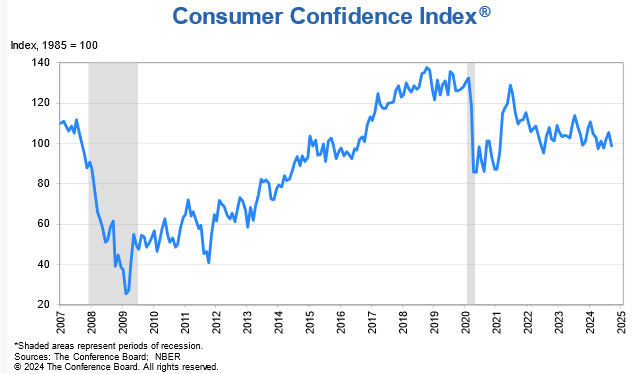
US stocks experienced modest gains on Tuesday, with both the S&P 500 and Dow Jones Industrial Average achieving record closes. Investor sentiment was bolstered by China’s announcement of significant stimulus measures aimed at revitalizing its economy, which had a positive ripple effect on global markets. Notably, US-listed Chinese e-commerce stocks surged, with JD.com seeing a nearly 14% jump following the news. However, this optimism was tempered by a decline in US consumer confidence; the Conference Board’s index fell to 98.7 in September from 105.6 in August, missing economists’ expectations. The Federal Reserve’s recent interest rate cuts also contributed to market positivity, despite some dissent among policymakers regarding inflation risks. Fed Governor Michelle Bowman expressed concerns about potential inflationary pressures following last week’s half-point rate cut.


Click here to read our current Economic Forecast – September 2024 Economic Forecast: One Recession Flag Removed With Three Remaining


Today’s Economic Releases Compiled by Steven Hansen, Publisher:

The Conference Board Consumer Confidence Index® fell in September 2024 to 98.7 (1985=100), from an upwardly revised 105.6 in August. Consumer Confidence has been little changed in the the last 2 years. Dana M. Peterson, Chief Economist at The Conference Board added:

Consumer confidence dropped in September to near the bottom of the narrow range that has prevailed over the past two years. September’s decline was the largest since August 2021 and all five components of the Index deteriorated. Consumers’ assessments of current business conditions turned negative while views of the current labor market situation softened further. Consumers were also more pessimistic about future labor market conditions and less positive about future business conditions and future income. The drop in confidence was steepest for consumers aged 35 to 54. As a result, on a six-month moving average basis, the 35–54 age group has become the least confident while consumers under 35 remain the most confident. Confidence declined in September across most income groups, with consumers earning less than $50K experiencing the largest decrease. On a six-month moving average basis, consumers earning over $100K remained the most confident.

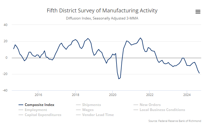
Richmond Fed manufacturing activity remained sluggish in September 2024. The composite manufacturing index edged down from −19 in August to −21 in September. Of its three component indexes, shipments decreased from −15 to −18, new orders increased from −26 to −23, and employment fell from −15 to −22. Manufacturing remains in a recession in the USA.

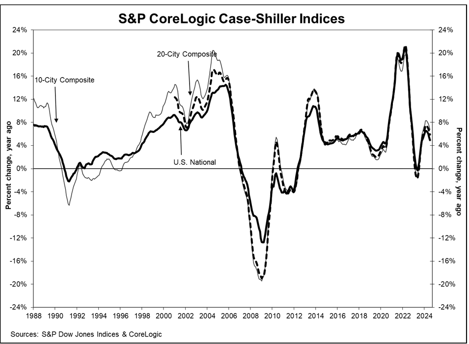
The S&P CoreLogic Case-Shiller 20-City Composite posted a year-over-year increase of 5.9% in July 2024, dropping from a 6.5% increase in the previous month. CoreLogic Chief Economist Dr. Selma Hepp explains:

With the summer characterized by broader cooling of housing demand amid high mortgage rates, home prices continued to weaken, and July monthly gains appear to be falling below the historical trend. Nevertheless, with a speedy decline in mortgage rates since August, housing market demand tracked by pending sales activity in CoreLogic data is finally showing signs of a rebound, which is expected to boost monthly price gains and return them to historical trends. Interestingly, the weakness in home prices remains in markets that have struggled with demand this year, including markets in Texas and Florida, while more expensive Western markets started to feel the pressure from rising rates in late spring. Going forward, home prices are likely to see a boost from a drop in mortgage rates and improved affordability.

Here is a summary of headlines we are reading today:

  • Rising EV Charging Costs Threaten UK’s Electric Vehicle Adoption
  • Saudi Aramco Looks To Raise $3 Billion from New Bond Issue
  • Goldman Sees Upside for Oil Prices Amid Supply Concerns
  • Coal’s Resurgence Challenges Global Energy Transition
  • The U.S. Is the World’s Top Gasoline Exporter
  • 81% of New Renewable Energy Capacity Added in 2023 Was Cheaper Than Fossil Fuels
  • ‘Stop ripping us off’: Senate grills Novo Nordisk CEO on weight loss drug pricing
  • September consumer confidence falls the most in three years
  • S&P 500 rises to new record high Tuesday, posts back-to-back gains: Live updates
  • ‘Childless cat lady’ is a more common lifestyle choice. Here’s what being child-free means for your money
  • US accuses Visa of debit card monopoly
  • Oil ends higher after back-to-back losses as China announces stimulus measures

Click on the “Read More” below to access these, other headlines, and the associated news summaries moving the markets today.

Weather Outlook for the U.S. for Today Through at Least 22 Days and a Six-Day Forecast for the World: posted September 24, 2024

This article focuses on what we are paying attention to in the next 48 to 72 hours. The article also includes weather maps for longer-term U.S. outlooks (up to four weeks) and a six-day World weather outlook which can be very useful for travelers.

First the NWS Short Range Forecast. The afternoon NWS text update can be found here after about 4 p.m. New York time but it is unlikely to have changed very much from the morning update. The images in this article automatically update.

Short Range Forecast Discussion
NWS Weather Prediction Center College Park MD
Tue Sep 24 2024
Valid 12Z Tue Sep 24 2024 – 12Z Thu Sep 26 2024

…Potential Tropical Cyclone Nine is forecast to pass not too far from
the Florida Keys Wednesday night as a hurricane before skirting up the
West Coast of Florida by Thursday morning…

…Much needed rainfall from the Ohio Valley into the central to southern
Appalachians, Upper Tennessee Valley and Mid-Atlantic…

…Much above average temperatures continue across the West into the
Northern Plains and across the Gulf Coast into the Southeast…

A relatively benign mid- to upper-level trough that will likely bring
beneficial rainfall for the eastern U.S. is forecast to deepen when
another upper-level trough over the northern Plains drops southeast and
merges with the lead trough. The resulting trough amplification will be
instrumental in pulling the tropical moisture as well as Potential Cyclone
Nine (PTC9) northward into the eastern portion of the Gulf of Mexico by
the end of the short-range forecast period on Thursday morning.

The initial impacts from the lead trough will be in the form of an
expanding area of moderate to heavy rainfall potential from the Midwest
into the lower Great Lakes, Ohio Valley, upper Tennessee Valley, central
to southern Appalachians into the Mid-Atlantic near and ahead of a low
pressure wave. Much of these areas are currently experiencing severe to
exceptional drought conditions, with the expected 1 to 1.5 inch plus
rainfall amount over the next two days bringing some relief to these
drought conditions. With the dry conditions across these areas, river
flooding will be unlikely. However, there is still at least a marginal
risk of isolated flash flooding with the expected heavy rainfall amounts,
especially if they occur over urbanized regions.

As the above-mentioned amplifying pattern develops over the northern
Plains and dips toward the Deep South, PTC9 is forecast to track more
toward the north and intensify rapidly as it moves across the Yucatan
Channel on Wednesday and then pass not too far from the Florida Keys
Wednesday night. The Florida Keys can expect strengthening winds with
more frequent passages of squally downpours Wednesday night as PTC9 is
forecast to pass to the west as a hurricane. Computer models indicate
that the circulation of PTC9 will expand as it interacts with the
deepening upper trough in the Deep South. Given a more robust convective
structure concentrated more on the east side of the storm, the West Coast
of Florida could begin to see more frequent and intense squalls with winds
further strengthening by Thursday morning. Please refer to the National
Hurricane Center for the latest updates on this system.

The amplifying upper ridge across the interior West will be supporting
widespread much above average temperatures over the next few days across
nearly all of the West and into the Northern Plains. High temperatures
across these regions are forecast to be as much as 10 to 20 degrees above
average. Above average temperatures also likely across the Gulf Coast and
into the Southeast. While temperatures are forecast to be much above
across these areas over the next few days, there are not expected to be
many record highs. However, more numerous record high morning
temperatures are possible both today and Wednesday morning along the West
coast and from portions of the southern Mid-Atlantic into the Southeast
and Florida. Across the Pacific Northwest, the cold front associated
with a Pacific cyclone centered over the Gulf of Alaska will only bring
some rainfall into the region by Wednesday.

cone graphic

To get your local forecast plus active alerts and warnings click HERE and enter your city, state or zip code.


Learn about wave patterns HERE.

Then, looking at the world and of course, the U.S. shows here also. Today we are looking at precipitation.

Please click on “Read More” below to access the full Daily Report issued today.

23 SEPT 2024 Market Close & Major Financial Headlines: The Dow Opened Recording A New Historic High, Then Continued To Trade Sideways Closing At A New High

Summary Of the Markets Today:

  • The Dow closed up 61 points or 0.15%, (Closed at 42,124, New Historic high 42,190)
  • Nasdaq closed up 0.14%,
  • S&P 500 closed up 0.28%,
  • Gold $2,651 up $5.10,
  • WTI crude oil settled at $71 down $0.45,
  • 10-year U.S. Treasury 3.747 up 0.019 points,
  • USD index $100.89 up $0.17,
  • Bitcoin $63,443 down $187 or 0.29%,

*Stock data, cryptocurrency, and commodity prices at the market closing

Today’s Highlights

US stocks rose on Monday, with the Dow Jones Industrial Average and S&P 500 reaching new record closing highs. Investors are looking ahead to key economic data releases and Federal Reserve speakers for clues about future rate cuts. The main focus is on

  • Friday’s PCE index reading (the Fed’s preferred inflation gauge)
  • Thursday’s second quarter GDP print Remarks from Fed officials, including Chair Jerome Powell Federal Reserve Insights

Fed officials Raphael Bostic and Neel Kashkari explained their support for the recent 50 basis point rate cut, citing progress on inflation and a cooling job market. Investors are closely watching for further comments from Fed officials, especially given the rare lack of unanimity in the last decision. Tesla (TSLA) stock rose on a bullish delivery forecast ahead of its robotaxi day in October. Intel (INTC) shares jumped after Apollo Global Management reportedly offered a multibillion-dollar investment. Boeing (BA) shares increased 2% after raising its negotiation offer to its machinist union. General Motors (GM) stock dropped following a downgrade by Bernstein analysts, who cited earnings headwinds and cost concerns.


Click here to read our current Economic Forecast – September 2024 Economic Forecast: One Recession Flag Removed With Three Remaining


Today’s Economic Releases Compiled by Steven Hansen, Publisher:

The Chicago Fed National Activity Index (CFNAI) three-month moving average, CFNAI-MA3, decreased to –0.17 in August from –0.13 in July.  A zero value for the CFNAI has been associated with the national economy expanding at its historical trend (average) rate of growth; negative values with below-average growth (in standard deviation units); and positive values with above-average growth. Following a period of economic expansion, an increasing likelihood of a recession has historically been associated with a CFNAI-MA3 value below –0.70. Conversely, following a period of economic contraction, an increasing likelihood of an expansion has historically been associated with a CFNAI-MA3 value above –0.70 and a significant likelihood of an expansion has historically been associated with a CFNAI-MA3 value above +0.20. The bottom line here is that according to this index the USA economy has been relatively poor for the last two years – which roughly correlates to the elevated inflation situation.

Here is a summary of headlines we are reading today:

  • Three Mile Island Nuke to Reopen with Microsoft Contract
  • Oil Steadies Amid Israeli Bombardment of Southern Lebanon
  • Shell Abandons Norway’s Hydrogen Projects Due To Lack Of Demand
  • China’s Russian Oil Imports Jump 25% as Beijing Seeks Cheap Crude
  • Looming Port Strike Threatens to Cripple East Coast Supply Chains
  • U.S. Administration Backs $1-Billion Fund for Small Automakers Investing in EVs
  • Southwest Airlines tells staff ‘difficult decisions’ ahead in push to boost profits
  • S&P 500 rises to fresh record close Monday as traders aim to extend Fed cut relief rally: Live updates
  • How Foot Locker is waging a comeback after its breakup with Nike
  • FBI stats show murder dropped 11.6%, the largest single year decline in the last 20 years
  • Minneapolis Fed President Kashkari sees a slower pace of rate cuts ahead
  • Barclays & Goldman Analysts Share Tesla Vehicle Delivery Estimates With Clients
  • Investors clinging to cash face these two risks as the Fed cuts interest rates, researchers say

Click on the “Read More” below to access these, other headlines, and the associated news summaries moving the markets today.

Weather Outlook for the U.S. for Today Through at Least 22 Days and a Six-Day Forecast for the World: posted September 23, 2024

This article focuses on what we are paying attention to in the next 48 to 72 hours. The article also includes weather maps for longer-term U.S. outlooks (up to four weeks) and a six-day World weather outlook which can be very useful for travelers.

First the NWS Short Range Forecast. The afternoon NWS text update can be found here after about 4 p.m. New York time but it is unlikely to have changed very much from the morning update. The images in this article automatically update.

Short Range Forecast Discussion
NWS Weather Prediction Center College Park MD
Mon Sep 23 2024
Valid 12Z Mon Sep 23 2024 – 12Z Wed Sep 25 2024

…Threat of heavy rain and locally strong to severe thunderstorms will
slowly shift from the southern Plains this morning to the Ohio Valley,
central Appalachians and lower Great Lakes on Tuesday into early
Wednesday…

…Watching the western Caribbean Sea for tropical cyclone formation that
could bring strengthening winds and passing squally downpours into the
Florida Keys Tuesday night into Wednesday morning…

A low pressure consolidating over the southern Plains along a slow-moving
front is forecast to move northeastward through the Mid-Mississippi Valley
by tonight, then across the Midwest and Ohio Valley on Tuesday. Heavy
showers and some severe thunderstorms this morning across the southern
Plains are expected to taper off as today progresses but the threat of
heavy rain and locally strong to severe thunderstorms will increase from
the Mid-Mississippi Valley into the Midwest in the mean time. By Tuesday,
the center of the low will pass through the Midwest toward the lower Great
Lakes, the threat of heavy rain and embedded strong thunderstorms will
then develop well ahead of the low across the Ohio Valley, mainly from
Tuesday afternoon into Tuesday night. By early Wednesday, many areas
across the lower Great Lakes and the interior East Coast will be
enshrouded by showers and embedded thunderstorms. These showers and
storms will extend farther southwest near/along the trailing front across
the interior Gulf Coast states. Showers and periods of rain will also
move across the lower Great Lakes into the central Appalachians and
upstate New York in association with another wave of low pressure near the
front.

The upper-level low behind the slow-moving front will slide across the
central Plains, allowing much of the western U.S. to remain dry along with
a warming trend for the next couple of days. Meanwhile, colder air will
remain entrenched across the Plains behind the front but 90s will be
common in the afternoon across the South and into the interior Southeast
today and Tuesday ahead of the front. The outer edge of a Pacific cyclone
centered over the Gulf of Alaska will only bring some light rain into
northwestern Washington State this morning.

Farther south into the tropics, the National Hurricane Center continues to
watch the western Caribbean Sea for potential tropical cyclone formation.
Computer models now appear to be in good agreement for the system to move
northwestward and reach the Yucatan Channel by the time the short-range
forecast period ends Wednesday morning. This means that the Florida Keys
could experience strengthening winds along with passing squally downpours
from Tuesday night into Wednesday morning. Please refer to the National
Hurricane Center for the latest updates on this system.

To get your local forecast plus active alerts and warnings click HERE and enter your city, state or zip code.


Learn about wave patterns HERE.

Then, looking at the world and of course, the U.S. shows here also. Today we are looking at precipitation.

Please click on “Read More” below to access the full Daily Report issued today.

Fed Funds Rate and Inflation. Part 1

Notice:  This post has incorrect calculations for changes in the Fed Funds rate.  See Fed Funds Rate and Inflation: Part 1 – Corrected.

How does CPI inflation vary as the Fed Funds rate changes? That is the next question in our investigation of possible cause-and-effect relationships for changes in inflation.


Marriner S. Eccles Federal Reserve Board Building, Wikipedia,
Creative Commons Attribution-Share Alike 3.0 Unported license.

Weather Outlook for the U.S. for Today Through at Least 22 Days and a Six-Day Forecast for the World: posted September 22, 2024

This article focuses on what we are paying attention to in the next 48 to 72 hours. The article also includes weather maps for longer-term U.S. outlooks (up to four weeks) and a six-day World weather outlook which can be very useful for travelers.

First the NWS Short Range Forecast. The afternoon NWS text update can be found here after about 4 p.m. New York time but it is unlikely to have changed very much from the morning update. The images in this article automatically update.

Short Range Forecast Discussion
NWS Weather Prediction Center College Park MD
Sun Sep 22 2024
Valid 12Z Sun Sep 22 2024 – 12Z Tue Sep 24 2024

…A low pressure wave will bring showers and possible severe weather
across the central High Plains this morning…

…Rounds of heavy rain and embedded thunderstorms are expected to stretch
from the south-central Plains through the mid-Mississippi Valley, Midwest,
and into the Ohio Valley for the next couple of days…

…Locally heavy rain and strong thunderstorms moving across the interior
Mid-Atlantic this morning…

Much of the active weather for the next couple of days will continue to be
focused in the vicinity of a slow-moving frontal boundary stretching from
the south-central Plains through the mid-Mississippi Valley, Midwest, and
into the Ohio Valley. The strongest thunderstorms are expected to
traverse the Texas and Oklahoma Panhandles early this morning, and then
weaken during the day as they move farther east. Rounds of heavy rain and
embedded thunderstorms can also be found this morning across the central
Plains into the Midwest, followed by addition showers and thunderstorms
forming and moving across Lower Michigan during the day today.

By Monday, a low pressure wave is forecast to organize along the front and
move northeast across the south-central Plains. Showers and embedded
thunderstorms can be expected to accompany the low as well as the frontal
boundary. By Tuesday morning, showers and embedded strong thunderstorms
are expected to move across the Midwest toward the Ohio Valley as the low
pressure center tracks across the region.

Across the interior Mid-Atlantic, a subtle upper-level disturbance is
delivering a round of heavy rain with strong to locally severe
thunderstorms moving from north to south this morning. Meanwhile, recent
wet weather in the vicinity of Cape Cod is lingering into this morning.
As the slow-moving coastal cyclone begins to slide further out into the
Atlantic, the rain is forecast to end during the day today.

The high-elevation of central Colorado is waking up to some wet snow due
to an influx of colder air associated with the upper low. The upper low
will lift into the southern Plains, allowing much of the western U.S. to
remain dry for the next couple of days with near normal temperatures.
Colder air will surge down the Plains behind the front but 90s will be
common in the afternoon across the South into the interior eastern U.S.
ahead of the front.

To get your local forecast plus active alerts and warnings click HERE and enter your city, state or zip code.


Learn about wave patterns HERE.

Then, looking at the world and of course, the U.S. shows here also. Today we are looking at precipitation.

Please click on “Read More” below to access the full Daily Report issued today.

Midwest Drought Update – Published on September 21, 2024

Before we get started on this,  I want to include the key graphic from the Updated Four Season  Outlook that we discussed  HERE  yesterday.

The top row is what is now called the Mid-Month Outlook for next month which will be updated at the end of this month. There is a temperature map and a precipitation map. The second row is a three-month outlook that includes next month.

Some will need to click on “Read More” to read the full article.

Weather Outlook for the U.S. for Today Through at Least 22 Days and a Six-Day Forecast for the World: posted September 21, 2024

This article focuses on what we are paying attention to in the next 48 to 72 hours. The article also includes weather maps for longer-term U.S. outlooks (up to four weeks) and a six-day World weather outlook which can be very useful for travelers.

First the NWS Short Range Forecast. The afternoon NWS text update can be found here after about 4 p.m. New York time but it is unlikely to have changed very much from the morning update. The images in this article automatically update.

Short Range Forecast Discussion
NWS Weather Prediction Center College Park MD
Sat Sep 21 2024
Valid 12Z Sat Sep 21 2024 – 12Z Mon Sep 23 2024

…Threat of heavy rainfall and severe weather will be focused across the
central U.S. and into Midwest for the next couple of days…

…A slow-moving coastal storm will bring another rainy day today across
southeastern New England and coastal flooding during high tides for the
northern Mid-Atlantic coast…

…Much below normal temperatures surge into the central High Plains on
Sunday as above average temperatures shift east from the Plains into the
Ohio and Mississippi Valley…

Most of the active weather for the next couple of days will be focused
across the central U.S. and will slowly shift east into the Midwest by
Monday morning. This is in response to a vigorous upper-level low
pressure system that will swing across the Southwest today and then
interact with a surge of cool air down from western Canada. Thunderstorms
are expected to develop quickly later today across the southern High
Plains where severe weather will be possible as a cold front surges south
and clashes with warm and moist air lifted northward by the upper low. By
Saturday night into Sunday, the main activities will then gradually shift
east across the central Plains toward the mid-Mississippi Valley as low
pressure waves form along the front. Sunday into Monday morning will see
the potential of heavy rain shifting farther east into the Midwest and
toward the Ohio Valley. Meanwhile, colder air behind the system will
change the rain into wet snow across the higher elevations of Colorado
Rockies Saturday night into Sunday morning. Showers and embedded
thunderstorms can also be expected farther north near/behind the cold
front across the northern Plains today, into the upper Midwest tonight,
followed by the upper Midwest and the Great Lakes Sunday into Monday
morning.

Temperatures will fall precipitously on the backside of the cold front
over portions of the southern High Plains and central Plains beginning
Saturday. High temperatures in the 50s will represent 15 to 30 degree
departures from average for the aforementioned areas. Above average
temperatures will be in place across the Midwest and Southeast this
weekend as upper-level ridging extending from Mexico into Texas remains in
place. Elsewhere, a slow-moving coastal storm will bring another rainy
day across southeastern New England with coastal flooding during high
tides for the northern Mid-Atlantic coast for today before the storm
slowly moves out into the Atlantic on Sunday.

To get your local forecast plus active alerts and warnings click HERE and enter your city, state or zip code.


Learn about wave patterns HERE.

Then, looking at the world and of course, the U.S. shows here also. Today we are looking at precipitation.

Please click on “Read More” below to access the full Daily Report issued today.

20Sep2024 Market Close & Major Financial Headlines: Markets Close Mixed After Yesterday’s Record Close

Summary Of the Markets Today:

  • The Dow closed up 38 points or 0.09%,
  • Nasdaq closed down 0.36%,
  • S&P 500 closed down 0.16%,
  • Gold $2,647 up $31.90,
  • WTI crude oil settled at $72 down $0.18,
  • 10-year U.S. Treasury 3.739 down 0.001 points,
  • USD index $100.79 up $0.18,
  • Bitcoin $62,928 down $16 or 0.03%,
  • Baker Hughes Rig Count down 2 to 588

*Stock data, cryptocurrency, and commodity prices at the market closing

Today’s Highlights

US stocks closed mixed on Friday as the initial enthusiasm for potential rate cuts faded. Investors had initially embraced Fed Chair Jerome Powell’s message about interest rate cuts, but concerns about economic risks and potential market bubbles tempered enthusiasm. Despite the muted action, the major averages still ended the week in positive territory. Dow Jones Industrial Average: Managed to stay above 42,000, eking out another record close. The market’s rally slowed as investors reassessed the Federal Reserve’s stance on interest rate cuts. Traders are pricing in deeper cuts this year than policymakers’ projections, according to Fed Funds futures. Concerns about potential risks to economic growth persisted. Shares spiked nearly 8% following reports that Qualcomm had approached the company about a potential takeover – stock fell about 4% after the takeover approach news. FedEx shares slumped after reporting a sharp drop in profit, missing Wall Street estimates. Nike stock jumped after naming a new CEO amid pressure on sales.


Click here to read our current Economic Forecast – September 2024 Economic Forecast: One Recession Flag Removed With Three Remaining


Today’s Economic Releases Compiled by Steven Hansen, Publisher:

no releases today

Here is a summary of headlines we are reading today:

  • The State of Joe Sixpack in 2Q2024: Most Households Are Worse Off Than They Were One Year Ago
  • Canada’s Role in Global Energy Supply Critical for U.S., Says RBC Chief
  • Oil, Gas Drilling Stalls in U.S.
  • Gazprom Accelerates Pipeline Gas Transports to China
  • 3-Mile-Long Freight Trains Cause Traffic Nightmares in Texas
  • Three Mile Island Nuclear Power Plant to Restart Following Microsoft Agreement
  • Russia Boosts Use of Sanctioned Tankers to Export Its Oil
  • Tensions Between Israel and Hezbollah Reach Fever Pitch
  • Intel shares pop on report Qualcomm has approached it about takeover
  • The big post-Fed rally could get tested in week ahead: ‘A lot holds in the balance’ of the next few days
  • China-Mexico freight traffic surges in Trump, Biden tariff era, as companies find ways to evade U.S. trade war
  • Georgia Election Board Approves Rule Requiring Hand Count Of Ballots
  • The Fed rate cut scared me. Where should I invest my $127,000 in savings now?

Click on the “Read More” below to access these, other headlines, and the associated news summaries moving the markets today.

NOAA Updates its Seasonal Outlook on September 19, 2024 – Similar to the Outlook Issued last Month but the potential La Nina is Downgraded – Posted on September 20, 2024

On the third Thursday of the month right on schedule NOAA issued their updated Seasonal Outlook which I describe as their Four-Season Outlook because it extends a bit more than one year into the future. The information released also included the Mid-Month Outlook for the following month plus the weather and drought outlook for the next three months.  I present the information issued by NOAA and try to add context to it. It is quite a challenge for NOAA to address the subsequent month, the subsequent three-month period as well as the twelve successive three-month periods for a year or a bit more.

With respect to the long-term part of the Outlook which I call the Four-Season Outlook, the timing of the transition from Neutral to LaNina is challenging to predict.  We are now in ENSO Neutral. La Nina is the likely scenario soon, but the strength of the La Nina may be fairly  weak..

From the NOAA discussion:

“The most recent International Research Institute (IRI) for Climate and Society plume forecast of the Niño-3.4 SST index predicts a weak and a short duration La Niña, as indicated by the Niño-3.4 index values less than -0.5°C. This month, the latest North American Multi-Model Ensemble (NMME) guidance was relied upon, which predicts La Niña to emerge in the next couple of months and continue through the Northern Hemisphere winter. The continuation of negative subsurface temperatures and enhanced low-level easterly wind anomalies supports the formation of a weak La Nina. In summary, La Niña is favored to emerge in SON (71% chance) and is expected to persist through JFM 2025.”

“However, chances of a moderate to strong La Niña are currently less than 50% through the Fall and Winter. ENSO-neutral conditions are favored to re-emerge by the February-April (FMA) 2025 season.”

I personally would not have total confidence in this outlook given the uncertainty about there actually being a La Nina and its strength if it does happen.  I  do not have the JAMSTEC outlook yet but for sure they will lean towards a weak La Nina with Modoki characteristics. I do not have a lot of confidence that NOAA knows how to deal with a La Nina Modoki. But they may have it exactly correct.

Let’s Take a Look at the (mid-month) Outlook for October

It will be updated on the last day of August.

Then we look at a graphic that shows both the next month and the next three months.

The top row is what is now called the Mid-Month Outlook for next month which will be updated at the end of this month. There is a temperature map and a precipitation map. The second row is a three-month outlook that includes next month.  I think the outlook maps are self-explanatory. What is important to remember is that they show deviations from the current definition of normal which is the period 1991 through 2020.  So this is not a forecast of the absolute value of temperature or precipitation but the change from what is defined as normal or to use the technical term “climatology”.

Notice that the Outlook for next month and the three-month Outlook are dissimilar. This tells us that November and December will be substantially different than October.

The full NOAA Seasonal Outlook extends through October/November/December of 2025 (yes that is more than a year out). All of these maps are in the body of the article. Large maps are provided for October and the three-month period October/November/December  Small maps are provided beyond that through October/November/December of 2025 with a link to get larger versions of these maps.

NOAA provides a discussion to support the maps. It is included in the body of this article. In some cases, one will need to click on “read more” to read the full article. For those on my email list where I have sent the url of the article, that will not be necessary.