October 6, 1982

October 6, 1982

Do you remember what you were doing on October 6, 1982?

Perhaps not, as it was exactly 42 years ago.

But I do, because it was a special day for me – I finally “escaped” from “communist China” on that day – I left China for Japan on October 6, 1982!

No, I did not leave China in a boat, nor did I sneak out of China in darkness. Instead, together with 149 other “top” Chinese students, I left China with a huge honor: after being chosen by the government to pursue graduate degrees in Japan, we were warmly sent off by some government officials on that day in anticipation that we, upon completion of our studies in Japan, would all come back home, helping modernize China.

Weather Outlook for the U.S. for Today Through at Least 22 Days and a Six-Day Forecast for the World: posted October 6, 2024

This article focuses on what we are paying attention to in the next 48 to 72 hours. The article also includes weather maps for longer-term U.S. outlooks (up to four weeks) and a six-day World weather outlook which can be very useful for travelers.

First the NWS Short Range Forecast. The afternoon NWS text update can be found here after about 4 p.m. New York time but it is unlikely to have changed very much from the morning update. The images in this article automatically update.

Short Range Forecast Discussion
NWS Weather Prediction Center College Park MD
400 AM EDT Sun Oct 06 2024
Valid 12Z Sun Oct 06 2024 – 12Z Tue Oct 08 2024

…Tropical Storm Milton continues to intensify over the southwest Gulf of
Mexico and is expected to move northeastward towards the Florida Gulf
Coast…

…Very heavy rainfall well ahead of Tropical Storm Milton will arrive
across the Florida Peninsula and Keys bringing the threat of flash
flooding…

…Showers and thunderstorms expected for portions of the interior
Northeast Sunday with the threat for some large hail and damaging winds…

…Record-breaking heat will continue across California and the Southwest
through the remainder of the weekend and into early next week…

Tropical Storm Milton continues to intensify in the southwestern Gulf of
Mexico and is currently forecast by the National Hurricane Center (NHC) to
move northeastward towards the Gulf Coast of Florida, with a possible
landfall on Wednesday. However, potentially significant flooding impacts
are expected well ahead of the storm as anomalously moist tropical air and
instability increase south of a wavy frontal boundary draped across the
Florida Peninsula. There is now a Moderate Risk of Excessive Rainfall
(level 3/4) Sunday over South Florida for a more concentrated corridor of
thunderstorms producing intense downpours with totals that could exceed
5″. This will bring a more significant risk of scattered to numerous
instances of flash flooding in urban areas. A Slight Risk (level 2/4)
extends north along the Atlantic Coast and also west along the Gulf Coast
through the central Peninsula for additional scattered instances of flash
flooding. Another Slight Risk on Monday covers the Atlantic Coast of the
central Peninsula as well as the southwestern Gulf Coast and South Florida
as the threat for thunderstorms with very heavy rainfall and flash
flooding continues. Follow the latest forecast from the NHC for updated
information on the expected track and potential impacts mid-week.

An upper-level wave/surface frontal system will pass through areas of the
interior Northeast including the Appalachians, Lower Great Lakes, and the
Upper Ohio Valley Sunday bringing scattered showers and thunderstorms.
Sufficient instability ahead of the front as well as strong flow at the
low and mid-levels may lead to some more robust, severe thunderstorms. The
Storm Prediction Center (SPC) has highlighted western New York and
Pennsylvania as well as eastern Ohio and the northern Panhandle of West
Virginia with a Slight Risk (level 2/5) of severe weather mainly for the
threat of large hail and damaging winds. The SPC has also noted that gusty
winds and dry conditions behind a trailing cold front extending to the
southwest through the Midwest and into the central Plains will lead to an
Elevated Risk of fire weather. As the system continues eastward, showers
and thunderstorms will spread into the northern Mid-Atlantic late
Sunday/early Monday and into New England during the day Monday. Most of
the rest of the country will be without precipitation chances the next
couple of days expect the Pacific Northwest where rain chances will pick
up by later Monday ahead of a Pacific system.

A record-breaking late-season heat wave continues this weekend and into
early next week across central and southern California and the Desert
Southwest as a ridge of high pressure aloft persists over the region.
Forecast highs continue to soar into the upper 90s to low 100s outside of
the immediate coastal areas of central and southern California, with high
temperatures reaching as high as the low 110s for the interior portions of
the Desert Southwest. Numerous daily record-tying or record-breaking high
temperatures are expected to occur across the region going through Monday.
Heat-related advisories and warnings are in place as this persistent level
of major to extreme heat remains a danger to anyone without adequate
air-conditioning or hydration, and for those spending greater time
outdoors. While not quite as hot, highs will trend above average again for
most of the rest of the Intermountain West as well, with highs in the 70s
and low 80s for the northern Great Basin/Rockies and into the mid-80s for
the central Great Basin. These very warm temperatures will also spread
east out into the northern/central Plains early next week. In fact, by
Monday and Tuesday, some areas of the northern Plains are expected to see
high temperatures upwards of 20 degrees above average, reaching as high as
the upper 70s and low 80s. Much of the Ohio/Tennessee Valleys and
Mid-South/Lower Mississippi Valley will see unseasonably warm temperatures
well into the 80s on Sunday. A cold front passage will bring much cooler,
more seasonable temperatures to the Great Lakes/Ohio Valley Monday as
highs only top out in the 60s, with 70s into the Tennessee Valley and
Mid-South. Further south, hot temperatures will also continue for portions
of the southern Plains and Texas, with daily highs remaining in the upper
80s to mid-90s.

cone graphic

To get your local forecast plus active alerts and warnings click HERE and enter your city, state or zip code.

Learn about wave patterns HERE.

Then, looking at the world and of course, the U.S. shows here also. Today we are looking at precipitation.

Please click on “Read More” below to access the full Daily Report issued today.

Our Report on the JAMSTEC Three-Season Forecast – Can be Compared to the NOAA Outlook – Posted on October 5, 2024

The Japan Agency for Marine-Earth Science and Technology, or JAMSTEC, is a Japanese national research institute for marine-earth science and technology

From the JAMSTEC Discussion:

“The latest observations show that there are weak signs of a La Niña. However, the SINTEX-F ensemble mean predicts that a La Niña Modoki will develop in the boreal autumn and persist into the boreal winter, although there is a large uncertainty in the timing and amplitude of the event.”

Although it is a World forecast, it includes a forecast for North America since North America is part of the World. One might try to compare it to the NOAA Outlook we published recently which can be accessed HERE.

First, we take a look at the forecasted sea surface temperature anomalies (SSTA). JAMSTEC starts by forecasting the SSTA and Nino 3.4 Index on the first day of the month and from there it usually takes their models about two weeks to produce their seasonal forecast. I received it from JAMSTEC on September 25 which was much later than when NOAA issued their Seasonal Update this month.  The JAMSTEC model runs are based on conditions as of September 1, 2024. The NOAA Seasonal Outlook is based on conditions closer to the time when it was issued.

We do not have a full three-season forecast from JAMSTEC this month. We have forecast maps for  OND, DJF and MAM so it is really an eight-month forecast as OND and DJF overlap a bit. For each of these three-month Outlooks, I also show the corresponding NOAA Precipitation Outlook for comparison purposes. The two are remarkably similar which is very unusual.

We also have single-month JAMASTEC forecasts for October through March 2025. I have a single-month outlook for October from NOAA but not single-month outlooks for the other five months so I could not show those comparisons.

Let’s take a look.

This shows their forecast of sea surface temperature anomalies at three points in time. Blue is a cold anomaly and is associated with La Nina if it occurs in the Nino 3.4 measurement areas in the Pacific along the Equator. The cool anomaly along the Equator is somewhat further west than usual which gives it the Modoki characteristics.

The U.S.  funded some of the Modoki research but for some reason declines to mention it in their seasonal outlook discussions.

In the OND image above, look at that blob of cool (anomaly) water to the west along the Equator. Thus the La Nina has Modoki characteristics that impact the Walker circulation. I have written about that before. It raises questions about the reliability of our current approach to thinking about the ENSO Cycle. This is covered in another article that can be accessed HERE.

Of interest also is the neutrally cold water just off the West Coast of the U.S. and the warm water between Africa and the north coast of South America which can support tropical storms and hurricanes.

NOAA  publishes a similar SSTA  analysis. It can be accessed  HERE.

JAMSTEC uses the same definition of Normal (climatology) as NOAA. JAMSTEC does a better job at characterizing La Ninas and El Ninos than NOAA. JAMSTEC provides me with a lot of other information that I do not include in my articles to keep them to a manageable size for readers. That material is the atmospheric pressure patterns.

Some Readers will have to click on “Read More” to read the rest of the article which you need to read to see the forecasts. I can only include a certain amount of material in the lede.

Weather Outlook for the U.S. for Today Through at Least 22 Days and a Six-Day Forecast for the World: posted October 5, 2024

This article focuses on what we are paying attention to in the next 48 to 72 hours. The article also includes weather maps for longer-term U.S. outlooks (up to four weeks) and a six-day World weather outlook which can be very useful for travelers.

First the NWS Short Range Forecast. The afternoon NWS text update can be found here after about 4 p.m. New York time but it is unlikely to have changed very much from the morning update. The images in this article automatically update.

Short Range Forecast Discussion
NWS Weather Prediction Center College Park MD
Sat Oct 05 2024
Valid 12Z Sat Oct 05 2024 – 12Z Mon Oct 07 2024

…Record-breaking heat remains across California and the Southwest
through this weekend, while briefly overspreading portions of the Plains
and Midwest on Saturday…

…Strong winds and dangerous fire weather conditions are forecast from
the northern/central Rockies into the Plains on Saturday…

…Locally heavy rainfall will be possible across the immediate Gulf Coast
through Saturday, with more of a focus toward the Florida Peninsula by
late Sunday…

A record-breaking late-season heat wave continues over portions of
central/southern California and the Desert Southwest this weekend as
upper-level ridging persists over the region. Forecast highs will once
again soar into the upper 90s to low 100s outside of immediate coastal
areas in central/southern California and into the 100s to low 110s into
the Desert Southwest. Numerous daily record-tying/breaking highs will
likely be reached again following days of new record daily temperatures.
Heat-related advisories and warnings are in place as this persistent level
of major to extreme heat remains a danger to anyone without adequate
air-conditioning/hydration and those spending greater time outdoors. After
a brief period of more seasonable temperatures to the north following a
cold frontal passage, highs will trend above average again for most of the
rest of the Interior West by Sunday, with 70s into the northern Great
Basin/Rockies and 80s for the central Great Basin. Further to the east
over the central U.S., a brief period of upper-level ridging and strong
southerly flow ahead of an approaching system will bring some hotter high
temperatures to portions of the Midwest and Central Plains on Saturday.
Forecast highs into the low to mid-90s are upwards of 20 degrees above
average, and some record-tying/breaking temperatures possible here as
well. An approaching cold front will bring cooler, more seasonable air on
Sunday with highs back down into the 70s. The Southern Plains will remain
hot and above average south of the front through the weekend with upper
80s and low 90s forecast.

As noted, an upper-level wave will move quickly along the northern-tier of
the country this weekend with an accompanying surface frontal system. Lee
cyclogenesis east of the Rockies has led to a rapidly deepening area of
low pressure just north of the U.S./Canadian border, with a tightening
pressure gradient leading to widespread very strong, gusty winds across
the northern/central Rockies and into the northern/central Plains.
Wind-related advisories and warnings are in place for gusts upwards of
60-70 mph through Saturday. In addition, very dry conditions combined with
the gusty winds with cold frontal passage will also bring a significant
risk of wildfires. The Storm Prediction Center has highlighted areas from
northern Colorado/southern Wyoming into central Nebraska and southern
South Dakota with a Critical Risk of fire weather (level 2/3). Widespread
Red Flag Warnings and Fire Weather Watches cover much of the rest of the
region due to wildfire risk. Greater moisture further east will lead to
some showers and storms ahead of the frontal system over the Upper Great
Lakes by Saturday afternoon. Some moderate rainfall will be possible, and
strong dynamic forcing with the system could lead to some more potent
thunderstorms. A Slight Risk of severe weather (level 2/5) has been
introduced from the Storm Prediction Center in northeastern Wisconsin
mainly for the threat of some large hail. The system will continue into
the Northeast Sunday afternoon/evening with more showers and thunderstorms
expected.

An area of low pressure over the southwestern Gulf of Mexico and
increasing Gulf moisture will lead to periods of thunderstorms producing
locally heavy rainfall along the immediate Gulf Coast and eastward along a
surface trough/weak frontal boundary across the Florida Peninsula this
weekend. While storms may be generally ill-focused for any potential
flooding threat, a couple areas will see a low but non-zero risk. More
concentrated storms along a coastal trough nearby the far south Texas Gulf
Coast could lead to some isolated flash flooding on Saturday. Another
focus will be along and ahead of the weak frontal boundary through the
central Florida Peninsula on Sunday, with some isolated flash flooding
possible along the Florida Gulf Coast and South Florida. The National
Hurricane Center (NHC) continues to monitor this area of low pressure for
potential tropical development, though if something were to develop this
remains more likely after the current forecast period into next week.

cone graphic

To get your local forecast plus active alerts and warnings click HERE and enter your city, state or zip code.

Learn about wave patterns HERE.

Then, looking at the world and of course, the U.S. shows here also. Today we are looking at precipitation.

Please click on “Read More” below to access the full Daily Report issued today.

04Oct2024 Market Close & Major Financial Headlines: Market Surge Attributed To Strong Jobs Report

Summary Of the Markets Today:

  • The Dow closed up 341 points or 0.81%,
  • Nasdaq closed up 219 points or 1.22%,
  • S&P 500 closed up 51 points or 0.90%,
  • Gold $2,671 down $7.70 or 0.29%,
  • WTI crude oil settled at $74.43 up $0.77 or 1.02%,
  • 10-year U.S. Treasury 3.971 up 0.123 points or 1.0%,
  • USD index $102.48 up $0.49 or 0.48%,
  • Bitcoin $62,365 up $1,591 or 2.62%,
  • Baker Hughes rig count 585 down 2

*Stock data, cryptocurrency, and commodity prices at the market closing

Today’s Highlights

The stock market rallied strongly on Friday following a better-than-expected September jobs report: The strong jobs data suggests the labor market remains robust, boosting hopes for a “soft landing” for the economy. Financial and Consumer Discretionary stocks led the gains. The positive jobs report shifted expectations toward a smaller 25 basis point interest rate cut from the Federal Reserve next month, rather than a larger 50 basis point cut. Oil prices saw their biggest weekly gain in over a year due to the Israel-Iran conflict, though gains were pared on Friday after President Biden discouraged Israel from targeting Iranian oil fields. The US dockworkers’ strike ended after a tentative wage deal was reached. Concerns remain about the potential escalation of the Middle East conflict. Overall, stocks showed resilience in the face of various economic and geopolitical challenges, with major indexes closing out the week with gains and nearing record highs.


Click here to read our current Economic Forecast – October 2024 Economic Forecast: One More Recession Flag Removed Yet Little Headway On Inflation


Today’s Economic Releases Compiled by Steven Hansen, Publisher:

Total BLS nonfarm payroll employment increased by 254,000 (establishment survey) in September 2025, and the unemployment rate changed little at 4.1% (household survey).  In comparing the two surveys that comprise this report – the household survey estimates 430,000 jobs were added whilst the headline establishment survey shows only 254,000. The headline unemployment rate declined because of the significant increase in the number of jobs added combined with a 281,000 DECLINE in the number of unemployed. Well over 2/3rds of the employment gains were in three sectors – health care, leisure/hospitality, and government employment. Manufacturing lost 7,000 jobs. Weekly work hours declined from 34.3 to 34.2. I see little recessionary data in this report.

Here is a summary of headlines we are reading today:

  • Will EU’s EV Tariffs Ignite a Global Trade War?
  • Brazil Eyes Fresh Oil Boom as it Revitalizes Tupi Field
  • Iran Aims at Israel’s Gas Assets if Conflict Ignites
  • Natural Gas Demand From European Industry Is Set to Drop Again
  • OPEC+ Spare Capacity Could Cushion Oil Markets
  • Fears of World War III Are Greatly Exaggerated
  • Fed close to pulling off the elusive economic soft landing in 2024 after great September jobs report
  • East and Gulf Coast ports strike deal is not close to done: Automation still a big hurdle in ILA/USMX negotiations
  • Stellantis files federal lawsuit against UAW union over strike threats
  • Selena Gomez couldn’t afford to go to her first Disney casting—now she’s a billionaire startup founder
  • “Doghouse Is Back!”: Stellantis CFO Instructs Staff To Take “Drastic Measures” To Conserve Cash

Click on the “Read More” below to access these, other headlines, and the associated news summaries moving the markets today.

Weather Outlook for the U.S. for Today Through at Least 22 Days and a Six-Day Forecast for the World: posted October 4, 2024

This article focuses on what we are paying attention to in the next 48 to 72 hours. The article also includes weather maps for longer-term U.S. outlooks (up to four weeks) and a six-day World weather outlook which can be very useful for travelers.

First the NWS Short Range Forecast. The afternoon NWS text update can be found here after about 4 p.m. New York time but it is unlikely to have changed very much from the morning update. The images in this article automatically update.

Short Range Forecast Discussion
NWS Weather Prediction Center College Park MD
Fri Oct 04 2024
Valid 12Z Fri Oct 04 2024 – 12Z Sun Oct 06 2024

…Record-breaking heat remains across California and the Southwest
through this weekend, while also building into the central United States
on Saturday…

…Strong winds and dangerous fire weather concerns forecast throughout
the northern Great Basin, northern Rockies, and into the northern/central
Plains…

…Locally heavy rain possible across the immediate Gulf Coast as
unsettled weather develops in the Gulf of Mexico…

A Fall heatwave will continue into the weekend over portions of the Desert
Southwest and central/southern California as a persistent trend of
upper-ridging over the region remains in place. Numerous
record-tying/breaking highs are forecast as temperatures soar once again
into the upper 90s to 100s. Heat-related advisories/warnings are in place
as the heat remains at levels dangerous to anyone without adequate cooling
or hydration. While not quite as hot, temperatures will still be
well-above average Friday elsewhere across the Interior West, with highs
well into the 80s for many locations across the northern/central Rockies
and Great Basin. A cold front will bring cooler, more Fall-like
temperatures to the northern Great Basin/Rockies on Saturday. Higher
heights will also expand eastward over the central United States on
Saturday helping to spread much above average temperatures into portions
of the central/southern Plains and Upper Midwest. Forecast highs in the
80s to low 90s in the Upper Midwest and as high as the mid-90s in the
central Plains are upwards of 20 degrees above average, with
record-tying/breaking highs possible here as well.

A fast-moving upper-level wave/accompanying surface frontal system will
pass along the northern tier of the West and into the central U.S. over
the next couple of days. Some moderate to locally heavy rainfall will be
possible over the Pacific Northwest on Friday, with some lighter showers
into the northern Rockies. Additional showers/storms will accompany the
system as it reaches the Upper Great Lakes later Saturday and into the
early morning hours Sunday. However, the bigger story will be widespread
gusty winds and high fire danger with the fast moving system as it passes
through the northern Great Basin/Rockies Friday and into the northern High
Plains Saturday. Wind-related watches and warnings have been issued as
gusts higher than 60 mph can be expected, leading to risk of blowing
debris, potential property damage, and isolated power outages, as well as
difficult travel conditions especially for high-profile vehicles. In
addition, the gusty winds and very dry conditions ahead of the approaching
cold front with the system will bring an increased threat for wildfires.
The Storm Prediction Center has highlighted a Critical Risk (level 2/3) of
Fire Weather over portions of the northern Great Basin and central/eastern
Wyoming Friday, and the central Rockies into the central Plains on
Saturday. Much of the rest of the region is under Red Flag Warnings and
Fire Weather Watches.

Enhanced tropical moisture along the Gulf Coast will lead to periods of
moderate to locally heavy showers for the next few days. The lack of a
focusing system/boundary and scattered nature of the storms currently
suggests a low risk for flash flooding, but an isolated instance or two of
flash flooding cannot be ruled out. Elsewhere, some light to moderate
showers can be expected with a cold frontal passage through the Northeast
late Friday/early Saturday. High temperatures will generally be at to a
bit above average for the eastern U.S., with widespread 70s to the north
and 80s in the South.

To get your local forecast plus active alerts and warnings click HERE and enter your city, state or zip code.


Learn about wave patterns HERE.

Then, looking at the world and of course, the U.S. shows here also. Today we are looking at precipitation.

Please click on “Read More” below to access the full Daily Report issued today.

03 OCT 2024 Market Close & Major Financial Headlines: Markets Opened Sharply Lower, Continued Trading With Wide Swings, Mostly Sideways, Finally Closing Moderately Down In The Red

Summary Of the Markets Today:

  • The Dow closed down 185 points or 0.44%,
  • Nasdaq closed down 7 points or 0.04%,
  • S&P 500 closed down 10 points or  0.17%,
  • Gold $2,678 up $8.50 or 0.28%,
  • WTI crude oil settled at $74 up $3.83 or 5.31%,
  • 10-year U.S. Treasury 3.850 up 0.067 points or 0.54%,
  • USD index $101.97 up $0.30 or 0.3%,
  • Bitcoin $60,987 up $314 or 0.52%,

*Stock data, cryptocurrency, and commodity prices at the market closing

Today’s Highlights

U.S. stocks slipped on Thursday as investors turned their focus back to the economy and the upcoming monthly jobs report, while concerns over the Middle East conflict pushed oil prices higher. Here are the key points: Investors are bracing for the September jobs report to be released on Friday. This comes after a surprise uptick in private payrolls and signs of loosening in the labor market. Weekly jobless claims increased slightly from the previous week, indicating a general cooling trend in the labor market. A report from Challenger, Gray and Christmas showed planned layoffs in the U.S. decreased from a five-month high. The ongoing Israel-Iran crisis has contributed to rising oil prices for the third consecutive day. Brent crude and West Texas Intermediate futures both gained over 5% following comments from President Biden about a potential Israeli retaliatory attack on Iran’s oil facilities. Signs of labor market deterioration could prompt the Federal Reserve to consider another significant interest rate cut, following last month’s 0.5% reduction. Tesla stock continued to decline, falling more than 3% on Thursday, following disappointing delivery figures and reports of halting U.S. online orders for its cheapest Model 35.


Click here to read our current Economic Forecast – October 2024 Economic Forecast: One More Recession Flag Removed Yet Little Headway On Inflation


Today’s Economic Releases Compiled by Steven Hansen, Publisher:

New orders for manufactured goods in August 2024 were down 0.6% year-over-year – down from +3.8% the previous month. I believe that manufacturing remains in a recession and no action to re-shore manufacturing is evident.

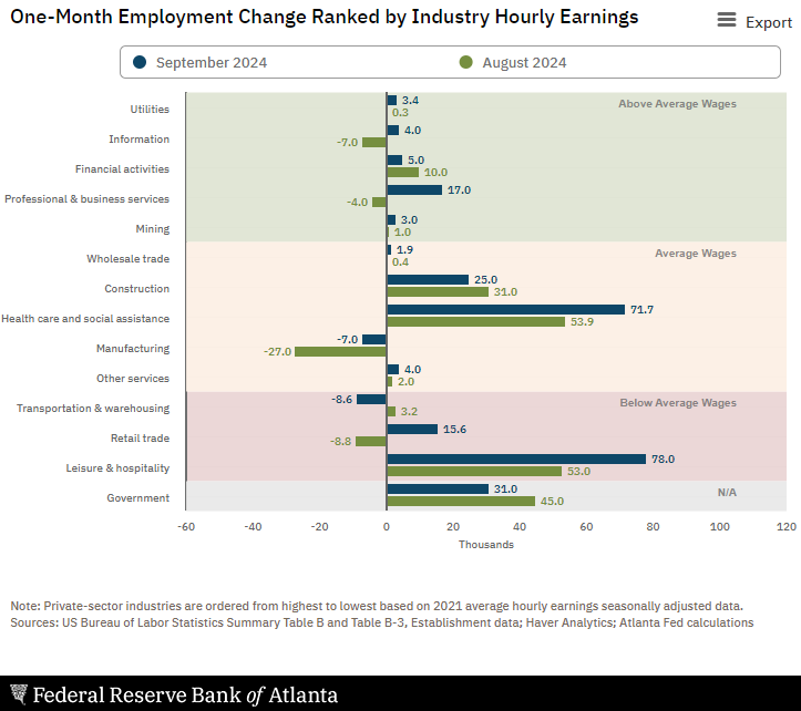
U.S.-based employers announced 72,821 job cuts in September 2024, a 4% decrease from the 75,891 cuts announced one month prior. It is up 53% from the 47,457 cuts announced in the same month in 2023. The current layoffs are a sign of a mature market where employers are trying to optimize profits. Andrew Challenger, Senior Vice President of Challenger, Gray & Christmas, Inc. added:

We’re at an inflection point now, where the labor market could stall or tighten. It will take a few months for the drop in interest rates to impact employer costs, as well as consumer savings accounts. Consumer spending is projected to increase, which may lead to more demand for workers in consumer-facing sectors. Layoff announcements have risen over last year, and job openings are flat. Seasonal employers seem optimistic about the holiday shopping season. That said, many of those who found themselves laid off this year from high-wage, high-skill roles, will not likely fill seasonal positions.

In the week ending September 28, the advance figure for seasonally adjusted initial unemployment claims 4-week moving average was 224,250, a decrease of 750 from the previous week’s revised average. The previous week’s average was revised up by 250 from 224,750 to 225,000. There is no sign of a recession in this data.

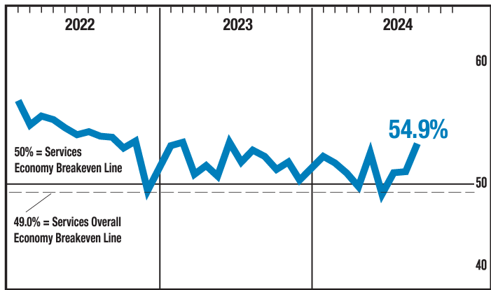
In September 2024 , the ISM Services PMI® registered 54.9%, 3.4 percentage points higher than August’s figure of 51.5 percent. The Business Activity Index registered 59.9 percent in September, 6.6 percentage points higher than the 53.3 percent recorded in August, indicating a third month of expansion after a contraction in June. The New Orders Index expanded to 59.4 percent in September, 6.4 percentage points higher than August’s figure of 53 percent. The Employment Index contracted for the first time in three months; the reading of 48.1 percent is a 2.1-percentage point decrease compared to the 50.2 percent recorded in August. These are not great numbers as the US is a services driven economy – but at least they are moving in the right direction.

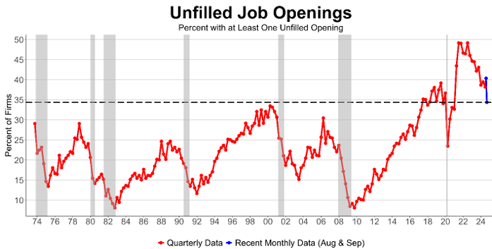
NFIB’s September jobs report found that 34% (seasonally adjusted) of small business owners reported job openings they could not fill in September, down 6 points from August and the lowest reading since January 2021. It appears that the abnormally high unfilled positions in small business is moderating. NFIB Chief Economist Bill Dunkelberg added:

Overall, the job market appears to be softening. Fewer small firms have openings they can’t fill as we head into fall. But many still report trouble finding qualified applicants and plans to increase compensation is once again on the rise.

Here is a summary of headlines we are reading today:

  • AI-Powered Disinformation Campaigns Target U.S. Voters
  • Nuclear Power Gains Momentum as Multiple Plants Seek Revival
  • Reuters Poll Shows OPEC September Output At Yearly Low
  • Oil Explodes 4% Amid Talk of Israel Attacking Iranian Oil & Gas
  • Bank of England Warns Middle East Conflict Could Lead to a Major Oil Price Shock
  • Here’s everything to expect when the September jobs report is released Friday
  • Panic buying amid U.S. ports strike is creating supermarket supply concerns
  • U.S. crude oil jumps as Biden comments on possible Israel retaliation against Iran
  • OpenAI gets $4 billion revolving credit line, giving it more than $10 billion in liquidity
  • States affected by Hurricane Helene warn of price gouging and other scams. Here’s how to avoid being a victim of post-storm schemes
  • Why Open AI’s $100 billion 2029 revenue target seems like a tech-fever dream
  • 10-year Treasury yield ends at highest level since August after better-than-expected ISM data

Click on the “Read More”

Weather Outlook for the U.S. for Today Through at Least 22 Days and a Six-Day Forecast for the World: posted October 3, 2024

This article focuses on what we are paying attention to in the next 48 to 72 hours. The article also includes weather maps for longer-term U.S. outlooks (up to four weeks) and a six-day World weather outlook which can be very useful for travelers.

First the NWS Short Range Forecast. The afternoon NWS text update can be found here after about 4 p.m. New York time but it is unlikely to have changed very much from the morning update. The images in this article automatically update.

Short Range Forecast Discussion
NWS Weather Prediction Center College Park MD
Thu Oct 03 2024
Valid 12Z Thu Oct 03 2024 – 12Z Sat Oct 05 2024

…Showers and thunderstorms return to the Gulf Coast from Thursday
evening into Saturday…

…Rain develops over the Pacific Northwest and scattered showers over
parts of the Midwest, Central/Southern Appalachians, and Northeast…

…There are Excessive Heat Warnings and Heat Advisories over parts of
Southern California and the Southwest…

On Thursday, tropical moisture will start to build over the
Central/Eastern Gulf Coast and Florida. Upper-level energy over the
Western Gulf Coast and Northern Gulf of Mexico will move into parts of the
Southeast and Central Gulf Coast, producing showers and thunderstorms over
parts of the Gulf Coast from Thursday evening into Saturday. In addition,
showers and thunderstorms will develop over parts of Florida through
Saturday. Furthermore, the moisture will also build over the
Central/Southern Appalachians, as upper-level energy moves over the area,
showers and thunderstorms will develop from Thursday afternoon into Friday
evening.

Meanwhile, a front extending from the Upper Great Lakes to parts of the
Central Plains will move eastward to just off the Northeast and
Mid-Atlantic Coast by Saturday. The boundary will produce rain with
embedded thunderstorms over parts of the Middle Mississippi Valley on
Friday morning into the early afternoon. As the front moves into the
Northeast and Mid-Atlantic, showers and thunderstorms will develop over
parts of the region late Friday evening into Saturday.

In addition, on Friday morning, a second front will move onshore over the
Pacific Northwest, moving to the Northern Plains by Saturday. The system
will produce rain over parts of the Pacific Northwest from Friday into
late Friday evening. Overnight Friday, wet snow will develop over the
highest elevations of the Cascades. The rain will expand into the Northern
Intermountain Region Friday evening into Saturday.

Moreover, the upper-level ridge over the Four Corners Region will create
high temperatures over Southern California and the Southwest, ranging from
the upper 90s to 110s. Low temperatures will be in the upper 80s to low
90s, providing little relief from the heat overnight. The temperatures
have prompted Excessive Heat Warnings and Heat Advisories over parts of
Southern California and the Southwest.

Record-breaking heat is expected across portions of the Southwest this
week. Moderate to major heat impacts are possible in areas near San
Francisco, Las Vegas, and Los Angeles. Extreme Heat Risk impacts are
forecast for parts of the Southwest. Remember, Heat is the Deadliest
Weather Phenomenon in the U.S.! People spending more time outdoors or in a
building without cooling are at an increased risk of heat-related illness.
Visit www.weather.gov/safety/heat and check local media and government
websites for information on cooling centers.

To get your local forecast plus active alerts and warnings click HERE and enter your city, state or zip code.


Learn about wave patterns HERE.

Then, looking at the world and of course, the U.S. shows here also. Today we are looking at precipitation.

Please click on “Read More” below to access the full Daily Report issued today.

02 OCT 2024 Market Close & Major Financial Headlines: Markets Opened Lower, Trended Upwards And Closed Fractionally Higher In The Green

Summary Of the Markets Today:

  • The Dow closed up 40 points or 0.09%,
  • Nasdaq closed up 0.08%,
  • S&P 500 closed up 0.01%,
  • Gold $2,680 down $10.60,
  • WTI crude oil settled at $71 up $1.13,
  • 10-year U.S. Treasury 3.783 up 0.04 points,
  • USD index $101.61 up $0.42,
  • Bitcoin $60,793 down $86 or 0.14%,

*Stock data, cryptocurrency, and commodity prices at the market closing

Today’s Highlights

U.S. stocks drifted higher on Wednesday despite escalating tensions between Israel and Iran, which had initially prompted caution in the market. Stocks had been under pressure at the start of October due to geopolitical concerns, which dampened previous optimism about potential U.S. interest rate cuts. Oil prices extended their surge, with Brent crude and West Texas Intermediate futures rising more than 1% on Wednesday. This follows a significant 5% spike on Tuesday, the largest increase in almost a year6. Traders are factoring in potential supply risks due to heightened attacks between Israel and Iran – as well as the ongoing port strikes on the east and gulf coasts. ADP data showed the private sector added 143,000 jobs in September, surpassing economists’ estimates of 125,000 and significantly higher than August’s 99,000. Tesla shares fell more than 3% as global deliveries rose in Q3 but fell short of Wall Street estimates. Nike shares dropped over 6% after withdrawing its annual outlook and reporting lower-than-expected Q1 revenue.


Click here to read our current Economic Forecast – October 2024 Economic Forecast: One More Recession Flag Removed Yet Little Headway On Inflation


Today’s Economic Releases Compiled by Steven Hansen, Publisher:

According to ADP National Employment Report, hiring showed a widespread rebound after a five-month slowdown, with private employers adding 143,000 jobs in September 2024. Year-over-year pay gains for job-stayers fell slightly in September to 4.7%. ADP chief economist Nela Richardson said: “Stronger hiring didn’t require stronger pay growth last month. Typically, workers who change jobs see faster pay growth. But that premium over job-stayers shrank to 1.9 percent, matching a low we last saw in January.” A 143,000 job gains is not excellent but not terrible either. After BLS’s last employment revision, the BLS employment data now aligns better with ADP – and I would expect Friday’s job report to be around 150,000.

Here is a summary of headlines we are reading today:

  • China’s Energy Grid Overwhelmed by Renewable Surge
  • Robots are Making Nuclear Energy Safer and More Efficient
  • OPEC+ Leaves Current Output Cut Policy Unchanged at JMMC
  • Oil Moves Higher Despite Rising U.S. Crude Inventories
  • Japan Maintains Energy Policy Focused on Boosting Nuclear and Renewables
  • The East and Gulf coast ports strike could be a no-win situation for the Biden administration
  • OpenAI closes funding at $157 billion valuation, as Microsoft, Nvidia, SoftBank join round
  • Dow ekes out narrow gain Wednesday as Middle East tensions weigh on markets: Live updates
  • Tesla stock slips after EV maker misses estimates on deliveries
  • JPM Analysts Flip-Flop iPhone 16 Demand Forecast In Just Three Days
  • 10-year Treasury yield rises from 1-week low as inflation worries return
  • Oil prices end at 2-week high as Israel weighs response to Iran missile attack

Click on the “Read More”