NOAA Updates its ENSO Alert on October 10, 2024 – We Remain in ENSO Neutral – Published October 11, 2024

Synopsis:  La Niña is favored to emerge in September-November (60% chance) and is expected to persist through January-March 2025. ”  

So we are really in ENSO Neutral but NOAA may not want to admit their forecast was wrong so they present it as waiting for La Nina. It is correct that we are in La Nina Watch but it is also correct that we currently remain in ENSO Neutral.

On the second Thursday of every month, NOAA (really their Climate Prediction Center CPC) issues its analysis of the status of ENSO. This includes determining the Alert System Status.  NOAA now describes their conclusion as “ENSO Alert System Status: La Nino Watch”

The exact timing of the transition is now perhaps more clear which should increase the reliability of the Seasonal Outlook to be issued next Thursday.

We have included an ENSO Blog article by Emily  Becker.

CLIMATE PREDICTION CENTER ENSO DISCUSSION (LINK)


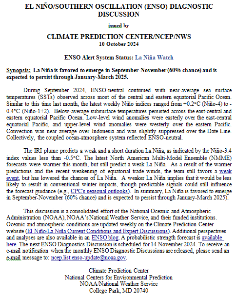
The second paragraph is what is important:

“The IRI plume predicts a weak and a short duration La Niña, as indicated by the Niño-3.4 index values less than -0.5°C. The latest North American Multi-Model Ensemble (NMME) forecasts were warmer this month, but still predict a weak La Niña.  As a result of the warmer predictions and the recent weakening of equatorial trade winds, the team still favors a weak event, but has lowered the chances of La Niña.  A weaker La Niña implies that it would be less likely to result in conventional winter impacts, though predictable signals could still influence the forecast guidance (e.g., CPC’s seasonal outlooks).  In summary, La Niña is favored to emerge in September-November (60% chance) and is expected to persist through January-March 2025).”

Below is the middle paragraph from the discussion last month.

“The IRI plume predicts a weak and a short duration La Niña, as indicated by the Niño-3.4 index values less than -0.5°C (Fig. 6).  This month, the team relies more on the latest North American Multi-Model Ensemble (NMME) guidance, which predicts La Niña to emerge in the next couple of months and continue through the Northern Hemisphere winter.  The continuation of negative subsurface temperatures and enhanced low-level easterly wind anomalies supports the formation of a weak La Niña.  A weaker La Niña implies that it would be less likely to result in conventional winter impacts, though predictable signals could still influence the forecast guidance (e.g., CPC’s seasonal outlooks).  In summary, La Niña is favored to emerge in September-November (71% chance) and is expected to persist through January-March 2025 (Fig. 7).”

We now provide additional details.

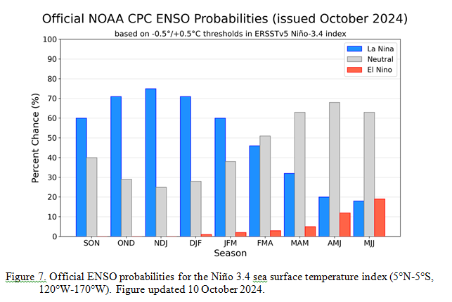
CPC Probability Distribution

Here are the new forecast probabilities. The probabilities are for three-month periods e.g. ASO  stands for August/September/October.

Here is the forecast from last month.

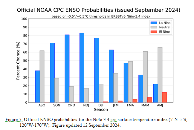
The analysis this month and last month are a bit different with again the transition to La Nina being slightly slower than thought last month. Also the probabilities of a La Nina are lower than estimated last month. This seems to be a trend. The chart is clearer than the discussion in the summary report above.  The La Nina is a bit slower to arrive. I am not sure that we will actually have a La Nina.

This graphic from Emily Becker’s ENSO Blog Post says it all.

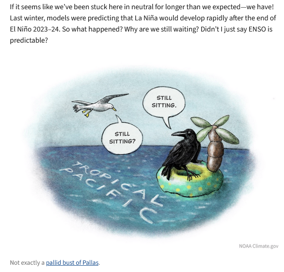
We have been waiting for this La Nina  a long time.

Some will need to click on “Read More” to read the rest of this article.

Weather Outlook for the U.S. for Today Through at Least 22 Days and a Six-Day Forecast for the World: posted October 11, 2024

This article focuses on what we are paying attention to in the next 48 to 72 hours. The article also includes weather maps for longer-term U.S. outlooks (up to four weeks) and a six-day World weather outlook which can be very useful for travelers.

First the NWS Short Range Forecast. The afternoon NWS text update can be found here after about 4 p.m. New York time but it is unlikely to have changed very much from the morning update. The images in this article automatically update.

Short Range Forecast Discussion
NWS Weather Prediction Center College Park MD
Fri Oct 11 2024
Valid 12Z Fri Oct 11 2024 – 12Z Sun Oct 13 2024

…Record-breaking heat forecast across parts of the Southwest and
south-central United States…

…Developing storm system to bring unsettled weather to the Ohio Valley,
Great Lakes, and Northeast this weekend…

…Locally heavy rain possible over southeast Florida…

Predominant upper-level ridging stretching from the Southwest to the
southern High Plains will allow for another day of record-breaking heat
across parts of Nevada and Arizona today. High temperatures are forecast
to reach into the upper 90s and triple digits, with temperatures only
expected to be a few degrees cooler this weekend. Meanwhile, heat is
anticipated to expand across the south-central U.S. by Saturday as highs
into the mid-90s engulf the southern Plains. Well above average
temperatures should span into the central Plains and mid-Mississippi
Valley as well, with numerous daily record high temperatures possible.
Cooler and more fall-like temperatures will be found across the East
today, with areas of frost likely from the central Appalachians to the
Northeast early this morning.

The next autumn cold front to impact the Nation is forecast to cross the
Great Lakes and Northeast by Saturday before stalling over the
Mid-Atlantic on Sunday. An area of low pressure developing along this
frontal boundary is expected to deepen and move eastward over the Ohio
Valley and Lower Great Lakes. Areas of showers and thunderstorms
surrounding the system may dampen outdoor activities, with a few isolated
strong thunderstorms possible between eastern Kentucky and West Virginia.

Following in the wake of Hurricane Milton, strong northeasterly flow aided
by a high pressure system over the southern Appalachians will provide the
potential for continued coastal hazards as well as locally heavy rain
along the Atlantic Coast of Florida. Developing thunderstorms along the
southeast Florida coastline in particular may remain somewhat stationary
due to opposing flow aloft, while also containing intense rainfall rates.
A Marginal Risk (level 1/4) of Excessive Rainfall has been issued for this
region on Saturday and Sunday in order to highlight the threat of
localized flash flooding.

To get your local forecast plus active alerts and warnings click HERE and enter your city, state or zip code.

Learn about wave patterns HERE.

Then, looking at the world and of course, the U.S. shows here also. Today we are looking at precipitation.

Please click on “Read More” below to access the full Daily Report issued today.

10 OCT 2024 Market Close & Major Financial Headlines: Wall Street’s Three Main Indexes Opened Moderately Lower, Finally Closing Fractionally Down In The Red

Summary Of the Markets Today:

  • The Dow closed down 58 points or 0.14%,
  • Nasdaq closed down 10 points or 0.05%,
  • S&P 500 closed down 12 points or 0.21%,
  • Gold $2,647 up $20.90 or 0.79%,
  • WTI crude oil settled at $76 up $2.72 or 3.71%,
  • 10-year U.S. Treasury 4.071 down 0.004 points or 0.035%,
  • USD index $102.86 down $0.07 or 0.06%,
  • Bitcoin $59,796 down $960 or 1.9%,

*Stock data, cryptocurrency, and commodity prices at the market closing

Today’s Highlights

The latest consumer inflation report in the US came in higher than expected, causing stocks to decline on Thursday. The Consumer Price Index (CPI) rose 0.2% month-over-month in September, above the expected 0.1% increase. Core inflation, excluding food and energy, increased 0.3% month-over-month and 3.3% year-over-year. The hotter-than-expected inflation data has reduced expectations for interest rate cuts by the Federal Reserve. Traders now see a 17% chance of no rate cut in November, up from 0% a week ago. Initial unemployment claims rose unexpectedly to 258,000, the highest level since August 2023. The 10-year Treasury yield increased to 4.1%, its highest level since late July.


Click here to read our current Economic Forecast – October 2024 Economic Forecast: One More Recession Flag Removed Yet Little Headway On Inflation


Today’s Economic Releases Compiled by Steven Hansen, Publisher:

The Consumer Price Index declined from 2.6% to 2.4% year-over-year in September 2024. If food and energy are excluded inflation remains little changed at 3.3% year-over-year. The driving force in moderating inflation is energy but everywhere I look – there are inflationary pressures present.

In the week ending October 5, the advance figure for seasonally adjusted initial unemployment claims 4-week moving average was 231,000, an increase of 6,750 from the previous week’s unrevised average of 224,250. The increase this week is attributable was Hurricane Helene. Natural disasters like hurricanes often lead to temporary spikes in unemployment claims as businesses are forced to close or reduce operations in affected areas.. There is no recessionary trend in this data.

Here is a summary of headlines we are reading today:

  • Australia’s First Major Waste-to-Energy Plant Sparks Debate
  • U.S. Clears ConocoPhillips to Recover Venezuela Assets
  • The Price of Charging an EV in Europe
  • Saudi, UAE, Qatar Lobbying DC to Keep Gulf Oil Safe from Israel
  • Finland’s Top Power Utility Targeted With Daily Cyber Attacks
  • AMD launches AI chip to rival Nvidia’s Blackwell
  • Dow and S&P 500 retreat from records as sticky inflation report weighs on stocks: Live updates
  • These income-generating assets are paying yields of more than 5%
  • TD Bank pleads guilty in money laundering case, will pay $3 billion in penalties
  • Stagflation Signal Stalls Stocks; Sparks Gold Gains
  • Stunning Foreign Demand For Strongest 30 Year Auction On Record
  • Trump floats new tax break for car loans, saying it’ll help buyers and auto industry

Click on the “Read More” below to access these, other headlines, and the associated news summaries moving the markets today.

Weather Outlook for the U.S. for Today Through at Least 22 Days and a Six-Day Forecast for the World: posted October 10, 2024

This article focuses on what we are paying attention to in the next 48 to 72 hours. The article also includes weather maps for longer-term U.S. outlooks (up to four weeks) and a six-day World weather outlook which can be very useful for travelers.

First the NWS Short Range Forecast. The afternoon NWS text update can be found here after about 4 p.m. New York time but it is unlikely to have changed very much from the morning update. The images in this article automatically update.

Short Range Forecast Discussion
NWS Weather Prediction Center College Park MD
Thu Oct 10 2024
Valid 12Z Thu Oct 10 2024 – 12Z Sat Oct 12 2024

…Impacts from Milton will wind down through early Thursday as the
Hurricane departs the Florida Peninsula and moves into the open Atlantic…

…Unseasonably very warm temperatures continue over much of the western
and central U.S., some record-tying/breaking highs will be possible…

…Most of the country will see dry conditions through Friday…

Impacts related to Hurricane Milton will be winding down early Thursday as
the storm continues to weaken and departs the Florida Peninsula into the
open Atlantic. Water levels from ongoing flooding and storm surge will
remain elevated and dangerous until the water has receded. As attention
turns to recover efforts, be aware of areas that remain flooded and do not
drive through flooded roadways. Some gusty winds may linger for Florida
and along the southeast Atlantic Coast. More isolated thunderstorms will
remain possible for central and south Florida through early Friday
morning.

Otherwise, the rest of the country will be mostly dry. Some isolated light
showers are possible in the Upper Great Lakes and interior Northeast on
Thursday, with some more moderate rainfall along coastal northern
California as a Pacific system approaches the area on Friday. The main
story will be continued very warm, well above average temperatures for
western and central portions of the country as a broad upper-level ridge
remains in place. Some of the greatest anomalies will be over the northern
Plains/Upper Midwest Thursday as highs soar into the mid-80s, upwards of
20-25 degrees above average. While temperatures have returned to less
dangerously hot levels compared to this past weekend, the Desert Southwest
still remains abnormally hot, with highs into the 100s. Elsewhere, highs
will be in the 80s in the Great Basin and lower elevations of the
central/southern Rockies, the mid- to upper 80s in the central Plains, and
into the mid-90s in Texas. Some record-tying/breaking highs will be
possible, especially in the Desert Southwest. A cold front moving through
the northern Rockies into the northern Plains/Upper Midwest will bring
cooler, more seasonable temperatures to in the 60s to these areas on
Friday. In contrast, much of the East Coast will be more seasonable and
even cool for northern locations. Forecast highs for the interior
Northeast and New England will only be in the 50s on Thursday, with 60s in
the Mid-Atlantic and 60s and 70s into the Southeast. Morning lows dipping
into the 30s for areas in the interior Northeast and within the
Appalachians could lead to some patchy frost Friday morning. Most of the
interior Northeast will see warmer temperatures Friday as highs climb back
into the 60s.

cone graphic

[Image of WPC Flash Flooding/Excessive Rainfall Outlook]

To get your local forecast plus active alerts and warnings click HERE and enter your city, state or zip code.

Learn about wave patterns HERE.

Then, looking at the world and of course, the U.S. shows here also. Today we are looking at precipitation.

Please click on “Read More” below to access the full Daily Report issued today.

09 OCT 2024 Market Close & Major Financial Headlines: Wall Street Main Indexes Opened Fractionally Lower And Trended Higher From There. The S&P 500 Recorded A New Historic High And The Indexes Closed Near Session Highs.

Summary Of the Markets Today:

  • The Dow closed up 432 points or 1.03%,
  • Nasdaq closed up 109 points or 0.60%,
  • S&P 500 closed up 41 points or 0.71%, (Closed at 5,792, New Historic high 5,797)
  • Gold $2,627 down $8.20 or 0.31%,
  • WTI crude oil settled at $74 down $0.07 or 0.10%,
  • 10-year U.S. Treasury 4.071 down 0.036 points or 0.285%,
  • USD index $102.92 up $0.37 or 0.36%,
  • Bitcoin $63,127 down $1,141 or 1.84%,

*Stock data, cryptocurrency, and commodity prices at the market closing

Today’s Highlights

US stocks rose on Wednesday, with the S&P 500 and Dow Jones Industrial Average closing at new record highs. The Nasdaq Composite also gained after paring earlier losses. The market was focused on several key developments, including the US Department of Justice considering asking a judge to force Google to sell off parts of its business to address its monopoly in internet search. This news initially pressured Alphabet shares. The minutes from the Fed’s September meeting showed a “substantial majority” of officials supported the 50 basis point interest rate cut, but some favored a smaller 25 basis point cut. This suggests a slightly more hawkish sentiment than previously thought. Investors are awaiting the release of the September Consumer Price Index (CPI) report on Thursday, which will provide further insight into inflation trends and potentially influence the Fed’s future rate decisions. Market expectations for the Fed’s November meeting have shifted, with a 24% chance now priced in for no rate cut, up significantly from previous estimates.


Click here to read our current Economic Forecast – October 2024 Economic Forecast: One More Recession Flag Removed Yet Little Headway On Inflation


Today’s Economic Releases Compiled by Steven Hansen, Publisher:

August 2024 sales of merchant wholesalers were up 1.1% from the revised August 2023 level. Total inventories of merchant wholesalers were up 0.6% from the revised August 2023 level. The August inventories/sales ratio for merchant wholesalers, except manufacturers’ sales branches and offices, based on seasonally adjusted data, was 1.35. The August 2023 ratio was 1.35. Employment in this sector is up 0.7% which suggests there is marginal growth  In fact, using US Census own numbers – we see sales growth over 2% year-over-year – and relatively the same as the previous month. Bottom line is that there is no indication of a recession or slowing of this sector.

Here is a summary of the Participants’ Views on Current Conditions and the Economic Outlook in the minutes of the Federal Open Market Committee for the meeting held on September 17-18, 2024:

Participants expressed cautious optimism about inflation trends, noting that while inflation remains elevated, recent data suggests a sustainable return to the 2% target. Key factors influencing this outlook include diminishing pricing power among businesses and a slowdown in nominal wage growth, which is critical for controlling inflation in the services sector. Labor market conditions have eased, with a notable rise in the unemployment rate since April 2023. However, participants agreed that the labor market remains solid, with limited layoffs and manageable job vacancies. The overall economic activity is expanding at a steady pace, supported by resilient consumer spending despite some financial strains on low- and moderate-income households. Participants acknowledged risks to the economic outlook, with reduced upside risks to inflation and increased downside risks to employment. This balance of risks informed their decision to ease monetary policy by lowering the federal funds rate target range by 50 basis points to 4.75% to 5%. While some members preferred a more gradual reduction of 25 basis points, the majority agreed that this adjustment aligns with current economic indicators. Looking ahead, participants anticipate a gradual move toward a more neutral monetary policy stance as inflation trends down sustainably and employment remains near maximum levels. They emphasized that future monetary policy decisions will depend on ongoing economic developments rather than a predetermined course.

Since the meeting, there was a blowout BLS employment report which many believe is inflationary. Likely, this report will temper further federal funds rate reductions. As must know, I did not favor a reduction in the federal funds rate as I believed there remains a significant amount of inflationary pressures which have not moderated.

Here is a summary of headlines we are reading today:

  • Shale Producers Prioritize Profit Over Growth
  • Chevron Shuts Down Tampa Terminal As Hurricane Milton Approaches
  • Exxon Gets Rare Sell Rating On Oversupply Concerns
  • Russia’s Planned Idle Refining Capacity Raised by 67% for October
  • Mining Giant Rio Tinto to Buy Arcadium Lithium for $6.7 Billion
  • IEA: The World Is Not on Track to Triple Renewable Capacity by 2030
  • Dow jumps more than 400 points to record close, S&P 500 hits all-time high: Live updates
  • Fed officials were divided on whether to cut rates by half a point in September, minutes show
  • What the Google break-up threat means for Alphabet’s stock
  • Warren Buffett’s S&P 500 bet paid off. Experts weigh in on whether it’s still a winning strategy
  • FTC gets ‘troubling reports’ of price gouging for essentials ahead of Hurricane Milton
  • Milton Could Trigger $175 Billion Worst-Case Damage Scenario
  • FOMC Minutes Show Fed Considerably More Divided Over Size Of Rate Cut
  • This is your brain on screens: Phones and computers are creating a FOMO epidemic
  • Hurricane Milton is upending cruise itineraries: What travelers need to know in such stormy situations

Click on the “Read More” below to access these, other headlines, and the associated news summaries moving the markets today.

Weather Outlook for the U.S. for Today Through at Least 22 Days and a Six-Day Forecast for the World: posted October 9, 2024

This article focuses on what we are paying attention to in the next 48 to 72 hours. The article also includes weather maps for longer-term U.S. outlooks (up to four weeks) and a six-day World weather outlook which can be very useful for travelers.

First the NWS Short Range Forecast. The afternoon NWS text update can be found here after about 4 p.m. New York time but it is unlikely to have changed very much from the morning update. The images in this article automatically update.

Short Range Forecast Discussion
NWS Weather Prediction Center College Park MD
Wed Oct 09 2024
Valid 12Z Wed Oct 09 2024 – 12Z Fri Oct 11 2024

…Major Hurricane Milton is expected to make landfall along the
west-central coast of Florida overnight Wednesday…

…Milton will bring life-threatening impacts to much of Florida including
a destructive storm surge, devastating hurricane-force winds, and
catastrophic flash and urban flooding…

…Unseasonably warm temperatures continue over much of the western and
central U.S., some record-tying/breaking highs will be possible…

Major Hurricane Milton continues to churn across the Gulf of Mexico early
Wednesday morning and is forecast to move northeastward and make landfall
along the west coast of Florida late Wednesday/early Thursday. Expected
impacts include a large area of destructive storm surge, with highest
inundations of 10 feet or greater, and devastating hurricane-force winds
along portions of the west-central coast of Florida. Milton is expected to
remain a hurricane while it crosses the peninsula bringing these
life-threatening hurricane-force winds, especially in gusts, inland.
Preparations to protect life and property, including being ready for
long-duration power outages, should be rushed to completion as winds and
rain will begin to pick up rapidly through the day Wednesday as the storm
approaches. In addition, there is a High Risk of Excessive Rainfall (level
4/4) Wednesday through at least mid-day Thursday across central and
northern portions of the peninsula. Extremely heavy rainfall totals
between 6 to 12 inches, locally up to 18 inches, will bring the risk of
catastrophic flash and urban flooding along with moderate to major river
flooding, especially in areas where coastal and inland flooding combine to
increase the overall flood threat. While Hurricane Milton is expected to
experience some weakening prior to landfall, the forecast for these
life-threatening impacts already takes this into account. Several
tornadoes will be possible as bands of thunderstorms move across the
central and southern Peninsula. The Storm Prediction Center has
highlighted portions of the central Peninsula in an Enhanced Risk (level
3/5) for the possibility of a strong tornado or two. Impacts from the
Hurricane will extend to the northeast along the southeastern Atlantic
Coast Thursday with life-threatening storm surge and gusty winds forecast.
Some rain will be possible, though the current forecast keeps the heaviest
rain off the coast over the Atlantic.

The rest of the country will be mostly quiet precipitation-wise other than
some showers for the interior Northeast/New England and the Pacific
Northwest Wednesday. The main story continues to be unseasonably warm
temperatures over much of the central and western U.S. under the presence
of upper-level ridging. Forecast highs are 10-20 degrees above average for
many locations, particularly over the northern Plains. Most will see highs
in the 80s across the Great Basin, Rockies, and northern/central Plains.
Even hotter temperatures into the low to mid-90s are expected for Texas
and interior central/southern California, with 100s in the Desert
Southwest. A few daily record-tying/breaking highs are possible,
particularly in the Desert Southwest. A cold front will bring cooler, more
seasonable temperatures in the 60s and low 70s to the northern Great
Basin/Rockies/High Plains on Thursday. In contrast, much of the eastern
U.S. will be more seasonable for Fall, and even a bit cool along the
northern tier. Forecast highs range in the 50s in the Upper Great
Lakes/Interior Northeast, the 60s and 70s for the Mid-Atlantic/Ohio
Valley, and the 70s and 80s in the South. Some patchy morning frost will
be possible for areas of the Upper Great Lakes/New England.

cone graphic

[Image of WPC Flash Flooding/Excessive Rainfall Outlook]

To get your local forecast plus active alerts and warnings click HERE and enter your city, state or zip code.

Learn about wave patterns HERE.

Then, looking at the world and of course, the U.S. shows here also. Today we are looking at precipitation.

Please click on “Read More” below to access the full Daily Report issued today.

08 OCT 2024 Market Close & Major Financial Headlines:Small Caps Opened Sharply Higher, While The Dow Struggled To Stay Above The Unchanged Line, Indexes Close Moderately Higher In The Green

Summary Of the Markets Today:

  • The Dow closed up 126 points or 0.30%,
  • Nasdaq closed up 259 points or 1.45%,
  • S&P 500 closed up 55 points or 0.97%,
  • Gold $2,641 down $25.40 or 0.95%,
  • WTI crude oil settled at $74 down $3.22 or 4.17%,
  • 10-year U.S. Treasury 4.026 down 0.002 points or 0.020%,
  • USD index $102.50 up $0.03 or 0.03%,
  • Bitcoin $62,239 down $997 or 1.44%,

*Stock data, cryptocurrency, and commodity prices at the market closing

Today’s Highlights

US stocks closed higher across the board on Tuesday, with tech stocks leading the gains. The S&P 500 closed near its previous record high. Key factors driving the market performance included Chipmaker Nvidia which led the bounce back in tech stocks. Other “Magnificent Seven” tech giants like Amazon, Apple, and Alphabet also finished firmly in positive territory. Oil prices retreated as Middle East tensions somewhat cooled. The pullback in surging oil prices helped shift investor focus back to interest rates and the US economy. Investors turned their attention to monetary policy, with Federal Reserve officials making comments about the economic outlook. Markets are still adjusting expectations after hopes for large interest rate cuts were dampened. China’s failure to announce another large stimulus package surprised investors and put pressure on oil prices. This led to a slump in Hong Kong stocks as the stimulus-fueled rally in Chinese equities fizzled out.


Click here to read our current Economic Forecast – October 2024 Economic Forecast: One More Recession Flag Removed Yet Little Headway On Inflation


Today’s Economic Releases Compiled by Steven Hansen, Publisher:

The NFIB Small Business Optimism Index rose by 0.3 points in September 2024 to 91.5. This is the 33rd consecutive month below the 50-year average of 98. NFIB Chief Economist Bill Dunkelberg stated:

Small business owners are feeling more uncertain than ever. Uncertainty makes owners hesitant to invest in capital spending and inventory, especially as inflation and financing costs continue to put pressure on their bottom lines. Although some hope lies ahead in the holiday sales season, many Main Street owners are left questioning whether future business conditions will improve.

August 2024 imports were up 6.8% year-over-year, exports up 5.8% year-over-year – and the resulting trade deficit up 18.1% year-over-year. The overall trade deficit is trending up because imports are increasing after a relative lull last year.

Here is a summary of headlines we are reading today:

  • EU Unveils New Sanctions to Counter Russian Hybrid Warfare
  • Tensions Rise as Ukraine Ends Russian Gas Transit Agreement
  • U.S. Set Record-Highs in Natural Gas Power Generation This Summer
  • Oil Prices Under Pressure as Supply Disruptions Fail to Materialize
  • Oil Prices Tumble 4% as Demand Fears Override Middle East Risk
  • Kinder Morgan Shuts Tampa Terminals Ahead of Hurricane Milton
  • Hurricane Milton could cause as much as $175 billion in damage, according to early estimates
  • S&P 500 jumps nearly 1%, Dow adds 100 points as cooler oil prices lift stocks: Live updates
  • The bull market turns two soon. History shows it should keep going, but some investors are wary
  • FTX cleared to repay nearly all customers 119% of allowed bankruptcy claims: CNBC Crypto World
  • Tampa Bay hasn’t been hit directly by a major hurricane since 1921. Milton may be the one
  • “Something Went Totally Nuts” At BLS But Labor Market Indicator Still Strongly Suggests Recession
  • Benchmark 10-year Treasury yield closes above 4% for a second day

Click on the “Read More” below to access these, other headlines, and the associated news summaries moving the markets today.

07Oct2024 Market Close & Major Financial Headlines: Markets Decline Not Helped by Geopolitical Concerns and Hurricane Milton

Summary Of the Markets Today:

  • The Dow closed down 399 points or 0.94%,
  • Nasdaq closed down 214 points or 1.18%,
  • S&P 500 closed down 55 points or 0.96%,
  • Gold $2,664 down $4.00 or 0.14%,
  • WTI crude oil settled at $77.33 up $2.95 or 3.98%,
  • 10-year U.S. Treasury 4.026 up 0.045 points or 1.0%,
  • USD index $102.50 up $0.03 or 0.363%,
  • Bitcoin $62,365 up $1,591 or 2.62%,
  • Baker Hughes rig count 585 down 2

*Stock data, cryptocurrency, and commodity prices at the market closing

Today’s Highlights

U.S. stocks fell on Monday, with major indexes dropping: The 10-year Treasury yield jumped above 4% for the first time since August. Fading hopes for aggressive Fed rate cuts after strong jobs report. Oil prices jumped over 3.5% on geopolitical concerns and Hurricane Milton. Judge ordered Alphabet to open Google Play app store to more competition, sending tech stocks lower. Nvidia was the only gainer in the “Magnificent 7”, rising about 2-3%. Amazon and Tesla were the biggest decliners, falling over 3% each Alphabet dropped over 2% on the Google Play ruling. Traders now see an 88% chance of a 0.25% Fed rate cut in November, down from previous bets on a larger 0.50% cut. The market will be closely watching key consumer inflation data coming later this week for further clues on the Fed’s next moves.


Click here to read our current Economic Forecast – October 2024 Economic Forecast: One More Recession Flag Removed Yet Little Headway On Inflation


Today’s Economic Releases Compiled by Steven Hansen, Publisher:

According to the Federal Reserve: “In August, consumer credit increased at a seasonally adjusted annual rate of 2.1 percent. Revolving credit decreased at an annual rate of 1.2 percent, while nonrevolving credit increased at an annual rate of 3.3 percent.” Revolving credit is mostly credit cards whilst non-revolving credit are for things like car loans and student loans. The only way to look at the numbers is analyzing year-over-year growth. Here we see revolving credit’s growth is 5.6% year-over-year, non-revolving credit growing 1.2% year-over-year, and total consumer credit growth at 2.3% year-over-year (1.2% inflation-adjusted). It appears consumer credit is growing even slower than economic growth.

Here is a summary of headlines we are reading today:

  • Kazakhstan’s Nuclear Power Vote Sparks Controversy
  • Crude Oil Soars over 3.5% As Hezbollah Strikes Haifa
  • Florida Restricts Port Activity as Hurricane Milton Hits Category 5
  • Hurricane Helene Exposes Tech Industry’s Fragile Supply Chain
  • China is on a LNG Stockpiling Spree
  • Saudi Arabia Raises Oil Prices to Asia
  • Is Israel Waiting For The U.S. Elections To Make Its Biggest Move Against Iran?
  • Google ordered to open Android app store in Epic Games trial
  • Consumers Crack: Credit Card Debt Suddenly Plunges Most Since Covid As APRs Hit Record High
  • The stock market’s response to geopolitical tension hasn’t followed the old script. Here’s why.

Click on the “Read More” below to access these, other headlines, and the associated news summaries moving the markets today.

Weather Outlook for the U.S. for Today Through at Least 22 Days and a Six-Day Forecast for the World: posted October 7, 2024

This article focuses on what we are paying attention to in the next 48 to 72 hours. The article also includes weather maps for longer-term U.S. outlooks (up to four weeks) and a six-day World weather outlook which can be very useful for travelers.

First the NWS Short Range Forecast. The afternoon NWS text update can be found here after about 4 p.m. New York time but it is unlikely to have changed very much from the morning update. The images in this article automatically update.

Short Range Forecast Discussion
NWS Weather Prediction Center College Park MD
Mon Oct 07 2024
Valid 12Z Mon Oct 07 2024 – 12Z Wed Oct 09 2024

…Hurricane Milton continues to intensify over the southwest Gulf of
Mexico and is expected to move northeastward towards the Florida Peninsula
by the middle of the week…

…Very heavy rainfall well ahead of Hurricane Milton brings the threat of
flash flooding to the central/southern Florida Peninsula and Keys…

…Record-breaking heat continues early this week for California and the
Desert Southwest, with much above average temperatures also expected for
the Intermountain West and Plains…

Hurricane Milton continues to intensify over the southwestern Gulf of
Mexico and is currently forecast by the National Hurricane Center (NHC) to
move northeastward and make landfall along the central Florida Gulf Coast
on Wednesday. However, potentially significant flash flooding impacts are
expected to continue well ahead of the storm as anomalously moist tropical
air and instability increase along a wavy frontal boundary draped across
the southern Florida Peninsula. Separate waves of low pressure along this
front will favor areas of very heavy to potentially extreme rainfall in a
concentrated fashion across portions of South Florida Tuesday, with a
Moderate Risk of Excessive Rainfall (level 3/4) in effect. This will bring
the potential for numerous instances of urban flash flooding. A broader
Slight Risk covers the central Atlantic Florida Coast as well as the
southwestern Gulf Coast for more scattered instances of flash flooding. A
Slight Risk is also in place on Tuesday as one wave departs and ahead of
the approach of Hurricane Milton, as locally very heavy rainfall and some
scattered instances of flash flooding will remain possible. Please consult
the latest NHC public advisories for updated information on the expected
track and impacts from Hurricane Milton as it approaches the Florida Gulf
Coast mid-week, including life-threatening storm surge, damaging winds,
and a continued threat of very heavy rainfall and widespread flash
flooding.

Meanwhile, a record-breaking late-season heat wave continues early this
week across areas of central and southern California and the Desert
Southwest as a ridge of high pressure aloft persists over the region.
Forecast highs Monday will once again soar into the upper 90s to low 100s
outside of the immediate coastal areas of central and southern California,
with high temperatures reaching as high as the low 110s for the interior
portions of the Desert Southwest. Heat-related advisories and warnings are
in place as this persistent level of major to extreme heat remains a
danger to anyone without adequate air-conditioning or hydration, and for
those spending greater time outdoors. Numerous daily record-tying or
record-breaking high temperatures are expected to occur across the region.
The one reprieve is that temperatures are expected to slowly drop through
the week beginning on Tuesday, with highs a few degrees lower and less
heat-related impacts expected. A few daily record-tying/breaking highs
still remain possible in the Desert Southwest though. While not quite as
hot, highs are also trending well above average for most of the rest of
the Intermountain West, with highs in the 70s and low 80s for the northern
Great Basin/Rockies and into the mid-80s for the central Great Basin.
These very warm temperatures will also spread east out into the
northern/central Plains as the ridge of high pressure shifts eastward this
week. Forecast highs the next couple of days are in the 70s to low 80s for
the northern Plains and into the mid-80s for the central Plains. Forecast
highs have continued to remain unseasonably warm for the Southern
Plains/Texas, with mid-80s to mid-90s expected.

Elsewhere, a cold front moving through New England will bring showers and
thunderstorms Monday, with a few storms lingering into Tuesday for
Downeast Maine. Forecast highs will be more seasonable for much of the
Midwest/Great Lakes into the Northeast following the cold front passage,
with highs in the 60s to low 70s. The South will be dry and a bit hot on
Monday ahead of the cold front, with highs generally in the mid- to upper
80s. Temperatures will drop to more seasonable levels on Tuesday here as
well after the cold front passes through, with highs in the 70s to low
80s. A system entering the Pacific Northwest will bring rain chances
Tuesday.

cone graphic

To get your local forecast plus active alerts and warnings click HERE and enter your city, state or zip code.

Learn about wave patterns HERE.

Then, looking at the world and of course, the U.S. shows here also. Today we are looking at precipitation.

Please click on “Read More” below to access the full Daily Report issued today.