05 NOV 2024 Market Close & Major Financial Headlines: Wall Street’s Small Caps Gapped Up Fractionally At The Opening Bell, By Early Morning Trading The Three Major Indexes Trended Sideways, Finally Closing Moderately Higher In The Green

Summary Of the Markets Today:

  • The Dow closed up 427 points or 1.02%,
  • Nasdaq closed up 259 points or 1.43%,
  • S&P 500 closed up 70 points or 1.23%,
  • Gold $2,753 up $6.20 or 0.22%,
  • WTI crude oil settled at $72 up $0.65 or 0.09%,
  • 10-year U.S. Treasury 4.289 down 0.022 points or 0.164%,
  • USD index $103.45 down $0.44 or 0.42%,
  • Bitcoin $69,358 up $1,949 or 2.81%, (24 Hours)

*Stock data, cryptocurrency, and commodity prices at the market closing

Today’s Highlights

US stocks closed higher on Election Day as Americans voted in the presidential race between Kamala Harris and Donald Trump. Investors are preparing for potential market volatility, as the election outcome may not be clear for days or weeks if disputed. The dollar retreated further as traders reduced bets on a Trump win. The 10-year Treasury yield dropped 2 basis points. The Federal Reserve is expected to announce a 25 basis point rate cut on Thursday. Boeing shares fell nearly 3% despite workers ending a 7-week strike by voting for a new contract with a 38% pay hike. The S&P 500 is up over 20% year-to-date through October, its best performance in the first 10 months of an election year since at least 1950. Historically, the S&P 500 has risen in 6 of the past 10 election cycles in the month after the election and 8 of 10 cases over the following 3 months. Analysts warn of potential short-term volatility once the election outcome is known, but advise investors to focus on long-term trends.


Click here to read our current Economic Forecast – November 2024 Economic Forecast: Our Index Marginally Declines – We Are Stuck With The Crappy Economy We Have Seen So Far This Year


Today’s Economic Releases Compiled by Steven Hansen, Publisher:

The trade deficit has grown 35.6% year-over-year driven by falling export growth of 4.5% year-over-year and rising import growth of 8.9%. Capital goods and consumer goods drove the rise in exports. When I was younger, the saying was that the US was manufacturing nothing  – it was not true then but becoming true now. 

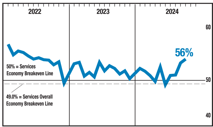
In October, the ISM Services PMI registered 56%, 1.1 percentage points higher than September’s figure of 54.9 percent. The reading in October marked the eighth time the composite index has been in expansion territory this year. The Business Activity Index registered 57.2 percent in October, 2.7 percentage points lower than the 59.9 percent recorded in September, indicating a fourth month of expansion after a contraction in June. The New Orders Index decreased to 57.4 percent in October, 2 percentage points lower than September’s figure of 59.4 percent. If I had only one index to look at to understand the economy, it would be this ISM services index even though this is a survey [I dislike most surveys]. It is showing moderate expansion. 

U.S. home price growth continued to cool, slowing to 3.4% year-over-year in September 2024. Compared with the month prior, home prices rebounded to post a very slight uptick (0.02%). Taken together, home price levels have been relatively flat since late summer. Home prices are subject to the laws of supply and demand – and there are a bunch of buyers currently priced out because of high mortgage rates. So if the mortgage rates moderate – home price inflation will increase.

Here is a summary of headlines we are reading today:

  • NATO Flexes Military Muscle with Extensive Drills in Northern Finland
  • Australia’s Rare Earth Supply Chain Faces Major Disruptions
  • Iran’s Oil Supply to China Most Expensive in Five Years As Loadings Fall
  • Foreign Interference Threatens U.S. Election Integrity, Officials Warn
  • Dow rallies 400 points, S&P 500 gains 1% as traders await U.S. election results: Live updates
  • Coinbase’s big election bet is about to be tested
  • Nvidia passes Apple as world’s most valuable company
  • Palantir shares jump 23% to record on uplifting guidance
  • Boeing machinists end strike after approving labor contract with 38% raises
  • Protests Explode In Tel Aviv After Netanyahu Fires Defense Minister Gallant
  • How Markets Reacted To Each US Election Since 2000
  • Ukraine Announces First Direct Clashes With North Korean Troops
  • 10-year Treasury yield ends lower after strong auction as investors await election results

Click on the “Read More” below to access these, other headlines, and the associated news summaries moving the markets today.

Weather Outlook for the U.S. for Today Through at Least 22 Days and a Six-Day Forecast for the World: posted November 5, 2024

This article focuses on what we are paying attention to in the next 48 to 72 hours. The article also includes weather maps for longer-term U.S. outlooks (up to four weeks) and a six-day World weather outlook which can be very useful for travelers.

First the NWS Short Range Forecast. The afternoon NWS text update can be found here after about 4 p.m. New York time but it is unlikely to have changed very much from the morning update. The images in this article automatically update.

Short Range Forecast Discussion
NWS Weather Prediction Center College Park MD
Tue Nov 05 2024
Valid 12Z Tue Nov 05 2024 – 12Z Thu Nov 07 2024

…Heavy rain and severe weather threats shifting east toward the
Arklatex, Mid-Mississippi Valley, and into the Midwest/Ohio Valley today…

…Mountain snow and wind will spread south from the northern Rockies
today, reaching into much of the central Rockies and Four Corners on
Wednesday into Thursday morning…

…Watching South Florida and especially the Florida Keys for impacts
associated with Tropical Storm Rafael forecast to become a hurricane as it
enters the southern Gulf of Mexico on Wednesday…

…Above average temperatures approaching record levels will spread across
the Mississippi Valley, Great Lakes, and East Coast…

The weather system that has sustained the heavy rain and severe weather
across the south-central U.S. for the past couple of days is beginning to
advance farther east. This is in response to a low pressure system
consolidating along the trailing front as supported by the final pieces of
energy of the deep upper trough reaching into the southern Plains. The
threats of heavy rain and severe weather today are shifting farther east
toward the Mississippi Valley this morning ahead of the front. As the low
pressure center tracks farther north across the upper Midwest today and
then into the Great Lakes by tonight, the heavy rain threat across the
Mississippi Valley will gradually lessen. The front is forecast to become
nearly stationary across the Ohio and Tennessee Valleys by Wednesday with
scattered showers and thunderstorms remaining in the vicinity into
Thursday morning.

Focus will then shift into the Gulf of Mexico as Tropical Storm Rafael is
forecast to track across western Cuba on Wednesday as a hurricane. The
Florida Keys will likely be closest to the path of Rafael with increasing
winds amid passing squally downpours associated with rainbands from Rafael
by later on Wednesday into Thursday morning. Please refer to the National
Hurricane Hurricane for the latest advisories on Rafael. Some moderate to
heavy rainfall well ahead of Rafael could move into the Southeast by
Wednesday night and continue into Thursday morning.

Weather out West is getting active again as another strong upper level
trough quickly digs across. A cold front and attendant low pressure system
have already traversed the Pacific Northwest. In addition to winter
weather across the mountains that has prompted winter weather advisories
and storm warnings, strong winds accompanying the low have also prompted
high wind warnings for the interior Pacific Northwest and portions of
Montana and Wyoming. The front will dip farther south into the southern
Rockies by Wednesday and then across the central and southern Plains by
Thursday morning. A round of new snow is expected to blanket much of the
Four Corners region behind the strong front. Temperatures will plunge as
an arctic air mass invades the region. Highs will be in the 30s and 40s
across the valleys and lows may approach the single digits in the cool
spots. Make sure to bundle up.

To get your local forecast plus active alerts and warnings click HERE and enter your city, state or zip code.

Learn about wave patterns HERE.

Then, looking at the world and of course, the U.S. shows here also. Today we are looking at precipitation.

Please click on “Read More” below to access the full Daily Report issued today.

04 NOV 2024 Market Close & Major Financial Headlines: Markets Opened Mixed, Slipped Below The Unchanged Line, Finally Closing Moderately Lower

Summary Of the Markets Today:

  • The Dow closed down 258 points or 0.61%,
  • Nasdaq closed down 60 points or 0.33%,
  • S&P 500 closed down 16 points or 0.28%,
  • Gold $2,746 down $2.80 or 0.09%,
  • WTI crude oil settled at $72 up $2.15 or 3.11%,
  • 10-year U.S. Treasury 4.299 down 0.064 points or 0.523%,
  • USD index $103.91 up $0.37 or 0.36%,
  • Bitcoin $67,474 down $1,579 or 2.34%, (24 Hours)

*Stock data, cryptocurrency, and commodity prices at the market closing

Today’s Highlights

U.S. stock markets declined on Monday as investors braced for two potentially market-moving events – the presidential election on Tuesday and the Federal Reserve’s policy decision later in the week. The major indexes all slipped: Trading was choppy as markets grappled with uncertainty around the tight presidential race between Kamala Harris and Donald Trump. Recent polls showing Harris gaining ground led to some recalibration of expectations. The dollar experienced its largest drop in a month as traders adjusted their positioning. Treasury yields also retreated, with the 10-year yield falling nearly 10 basis points. In other markets, oil prices jumped nearly 3% after OPEC+ delayed a planned production increase.


Click here to read our current Economic Forecast – November 2024 Economic Forecast: Our Index Marginally Declines – We Are Stuck With The Crappy Economy We Have Seen So Far This Year


Today’s Economic Releases Compiled by Steven Hansen, Publisher:

no releases today

Here is a summary of headlines we are reading today:

  • Libyan Oil Output Resumption Significantly Increases OPEC Output
  • TotalEnergies: Oil Demand Will Peak After 2030
  • Trudeau Government Orders Canadian Oil & Gas Firms To Cut Emissions
  • 20 States See Gasoline Prices Fall Below $3 Ahead of Presidential Elections
  • Is This The Eye Of The Coming Israeli Storm Of Attacks Directly On Iran?
  • South Korea Set to Buy More U.S. Oil and Gas If Trump Becomes President
  • Dow closes down more than 200 points ahead of presidential election: Live updates
  • Striking Boeing machinists vote on union-backed contract proposal, this time with a warning
  • What the stock market typically does after the U.S. election, according to history
  • Quantifying how much Nvidia will influence the Dow after it joins the storied average
  • Retailers brace for DEI blowback in lead-up to election, holiday shopping season
  • Stocks making the biggest moves midday: Nvidia, Berkshire Hathaway, Yum China and more
  • 10-year Treasury yield dives by most in a month after Iowa poll tilts in favor of Harris

Click on the “Read More” below to access these, other headlines, and the associated news summaries moving the markets today.

Weather Outlook for the U.S. for Today Through at Least 22 Days and a Six-Day Forecast for the World: posted November 4, 2024

This article focuses on what we are paying attention to in the next 48 to 72 hours. The article also includes weather maps for longer-term U.S. outlooks (up to four weeks) and a six-day World weather outlook which can be very useful for travelers.

First the NWS Short Range Forecast. The afternoon NWS text update can be found here after about 4 p.m. New York time but it is unlikely to have changed very much from the morning update. The images in this article automatically update.

Short Range Forecast Discussion
NWS Weather Prediction Center College Park MD
Mon Nov 04 2024
Valid 12Z Mon Nov 04 2024 – 12Z Wed Nov 06 2024

…More heavy rain and severe weather focusing across eastern Oklahoma to
the Midwest today will weaken and gradually shift east toward the
Mid-Mississippi Valley on Tuesday…

…Next round of mountain snow and wind will quickly overspread into the
Pacific Northwest today, across the northern Rockies on Tuesday, and then
into the central Rockies by Tuesday night…

…Watching South Florida and especially the Florida Keys for impacts
associated with Potential Tropical Cyclone Eighteen which is forecast to
reach hurricane strength by Wednesday morning…

…Above average temperatures approaching record levels will build across
the Mississippi Valley, Great Lakes, and East Coast…

The ongoing active weather system over the south-central U.S. will bring
another day of heavy rain and severe weather across the south-central
U.S., with the heaviest rainfall expected to impact eastern Oklahoma,
northwestern Arkansas, much of Missouri and into Illinois. In addition,
the Storm Prediction Center continues to highlight an Enhanced Risk (level
3/5) of severe thunderstorms centered around eastern Oklahoma and into
adjacent areas where damaging winds, large hail, as well as a few
tornadoes are mostly likely. More energy ejecting from the upper-level
trough currently spreading mountain snow across the Intermountain West
will consolidate a low pressure system over the south-central Plains
today. This system is forecast to push a cold front farther eastward by
tonight, ending the heavy rain threat across Oklahoma but then shifting
the heavy rain and severe weather threats into the Arklatex region,
Mid-Mississippi Valley and across Midwest on Tuesday. As the low pressure
center tracks quickly northeastward across the Great Lakes Tuesday night,
the trailing cold front will weaken with time, leading to a lessening
threat of heavy rain and severe weather farther east across the
Mid-Mississippi Valley on Tuesday. Nevertheless, moderate to locally heavy
rain with embedded thunderstorms are expected to reach into the Ohio and
Tennessee Valleys Tuesday night into Wednesday morning.

With another piece of energy associated the upper trough beginning to exit
the Southwest into the Plains today, mountain snow over central Colorado
will slowly taper off while mountain snow over New Mexico will linger into
this evening. A rather strong low pressure system from the Pacific Ocean
will quickly spread the next round of coastal rain into the Pacific
Northwest today followed by a good dose of mountain snow farther inland
along with windy conditions. The mountain snow will then reach into the
northern Rockies Monday night into Tuesday morning as the low pressure
system redevelops over the northern High Plains. The greatest chances
(>80%) for over 8 inches of snowfall in a 24-hour period is forecast over
the northern Cascades on Monday and northern Rockies on Tuesday. Be sure
to prepare for winter driving conditions if traveling throughout these
elevated mountain ranges and stay tuned to the latest local weather
forecast. By Tuesday night into Wednesday morning, the snow is forecast
to blanket the central Rockies into the central High Plains behind a polar
front.

Warmer and mostly dry conditions will be felt east of the Mississippi
River through early next week, besides rain chances throughout parts of
the Midwest and Great Lakes. A large high pressure system centered over
the Great Lakes is forecast to slide eastward and off the New England
coastline, ushering in warm southerly flow on the western periphery. This
will support widespread above average high temperatures into the upper 60s
and 70s from the central/southern Plains to the Mid-Atlantic early this
week, with 80s along the Gulf Coast States. When compared to early
November climatology, the Midwest and upper Ohio Valley is expected to
experience temperatures well above average. The anomalous warmth will
eventually spread to the East Coast by Election Day as showers and
thunderstorms ahead of the cold front continue throughout the Midwest and
Mississippi Valley.

In the mean time, the National Hurricane Center (NHC) has begun issuing
advisories on Potential Tropical Cyclone Eighteen (PTC 18) in the
southwestern Caribbean. This system has the potential to bring increasing
winds with the arrival of outer rainbands especially for the Florida Keys
by Wednesday morning as the cyclone is forecast to reach hurricane
strength by then. Please refer to the NHC for the latest advisory on PTC
18.

To get your local forecast plus active alerts and warnings click HERE and enter your city, state or zip code.

Learn about wave patterns HERE.

Then, looking at the world and of course, the U.S. shows here also. Today we are looking at precipitation.

Please click on “Read More” below to access the full Daily Report issued today.

Weather Outlook for the U.S. for Today Through at Least 22 Days and a Six-Day Forecast for the World: posted November 3, 2024

This article focuses on what we are paying attention to in the next 48 to 72 hours. The article also includes weather maps for longer-term U.S. outlooks (up to four weeks) and a six-day World weather outlook which can be very useful for travelers.

First the NWS Short Range Forecast. The afternoon NWS text update can be found here after about 4 p.m. New York time but it is unlikely to have changed very much from the morning update. The images in this article automatically update.

Short Range Forecast Discussion
NWS Weather Prediction Center College Park MD
Sun Nov 03 2024
Valid 12Z Sun Nov 03 2024 – 12Z Tue Nov 05 2024

…Another day of heavy rain and severe weather expected across the
central U.S. before shifting east into the Arklatex, Mid-Mississippi
Valley and Midwest by Monday night…

…Mountain snow moving across the Intermountain West and Rockies today
will begin to taper off on Monday as the next round of mountain snow and
wind quickly overspreads the Pacific Northwest on Monday…

…Above average temperatures approaching record levels will shift east
from the Plains today towards the Mississippi Valley by Monday with no
rain in sight along the East Coast…

The ongoing active weather system over the south-central U.S. will
continue to trigger additional rounds of heavy rain and severe weather for
the remainder of today, with the heaviest rainfall expected to impact
central to eastern Oklahoma into portions of northwestern Arkansas and
southern Missouri. More energy ejecting from the upper-level trough
currently spreading mountain snow across the Intermountain West will
eventually consolidate a low pressure system over the central High Plains
by tonight. This low pressure system will track northeastward across the
central Plains followed by another low pressure system to develop over the
south-central Plains on Monday. This second system is forecast to
push a cold front farther eastward Monday night, ending the heavy rain
threat across Oklahoma but shifting the heavy rain and severe weather
threats into the Arklatex region, Mid-Mississippi Valley and Midwest by
Monday night.

The upper trough will usher colder than normal temperatures through much
of the western U.S. for the next couple of days with mountain snow passing
through the Intermountain region today, followed by the central and
southern Rockies on Monday. Meanwhile, a rather strong low pressure
system from the Pacific Ocean will quickly spread the next round of
coastal rain into the Pacific Northwest on Monday followed by a good dose
of mountain snow farther inland along with quite a bit of wind. The
mountain snow will reach into the northern Rockies Monday night into
Tuesday morning as the low pressure system redevelops over the northern
High Plains. The greatest chances (>80%) for over 8 inches of snowfall in
a 24-hour period is forecast over the northern Cascades on Monday. Be
sure to prepare for winter driving conditions if traveling throughout
these elevated mountain ranges and stay tuned to the latest local weather
forecast.

Warmer and mostly dry conditions will be felt east of the Mississippi
River through early next week, besides rain chances entering parts of the
Midwest and Great Lakes. A large high pressure system centered over the
Great Lakes is forecast to slide eastward and off the New England
coastline by Monday, ushering in warm southerly flow on the western
periphery. This will support widespread above average high temperatures
into the upper 60s and 70s from the central/southern Plains to the
Mid-Atlantic by Monday, with 80s along the Gulf Coast States. When
compared to early November climatology, the Midwest is expected to
experience temperatures well above average on Monday. The anomalous
warmth will then spread across the Ohio Valley into the Great Lakes by
Monday night into early Tuesday as showers and thunderstorms ahead of the
cold front reach into the Midwest.

To get your local forecast plus active alerts and warnings click HERE and enter your city, state or zip code.

Learn about wave patterns HERE.

Then, looking at the world and of course, the U.S. shows here also. Today we are looking at precipitation.

Please click on “Read More” below to access the full Daily Report issued today.

Book Review: ‘Who Will Defend Europe? An Awakened Russia and a Sleeping Continent’

Despite frequent US calls to lift defence spending, most of NATO’s European members pocketed a ‘peace dividend’ in recent years by reducing their armed forces and defence industries. They imagined that war would never return to Europe and that, in any event, they could rely on the US to ensure their national security.

Both of these assumptions were illusory, as Keir Giles argues in a new book, Who Will Defend Europe? Giles is a senior fellow at Chatham House and Director of the Conflict Studies Research Centre. He has been a very active and prescient analyst of Russia, especially since the invasion of Ukraine, notably through his books Moscow Rules and Russia’s War on Everybody.

Drought Update – Posted November 2, 2024

Every week on Thursday, the Drought Monitor LINK is updated for every state in the U.S. plus most territories.


Row Crops


Livestock

Specialty Crops (Click HERE to access the links in this image).

And there is another source of information on drought from certain groupings of states that operate what is called a Drought Early Warming System (DEWS). They sometimes have webinars and may issue reports without having a webinar. Not all parts of the U.S. are covered. These groups of states seem to issue reports every two months. I am only showing the recent reports since a month-old report at this time of the year can be misleading.

To get to that part of this article where I provide these reports you may have to click on “Read More”. I provide information for all of the existing DEWS which is current (issued in October or today).

Weather Outlook for the U.S. for Today Through at Least 22 Days and a Six-Day Forecast for the World: posted November 2, 2024

This article focuses on what we are paying attention to in the next 48 to 72 hours. The article also includes weather maps for longer-term U.S. outlooks (up to four weeks) and a six-day World weather outlook which can be very useful for travelers.

First the NWS Short Range Forecast. The afternoon NWS text update can be found here after about 4 p.m. New York time but it is unlikely to have changed very much from the morning update. The images in this article automatically update.

Short Range Forecast Discussion
NWS Weather Prediction Center College Park MD
Sat Nov 02 2024
Valid 12Z Sat Nov 02 2024 – 12Z Mon Nov 04 2024

…Frequent rounds of heavy rain and severe weather expected across the
central and southern Plains throughout this weekend and into Monday…

…Mountain snow will spread from the Pacific Northwest into much of the
Intermountain West over the next couple of days…

…Much above average temperatures expected across large portions of the
central to eastern U.S. with no rain in sight along the East Coast…

An upper-level trough digging into the western U.S. will be pushing
against a ridge of high pressure building across the eastern U.S. This
will result an amplifying weather pattern across the mainland U.S. through
this weekend, with the most vigorous battle zone occurring over the
south-central U.S. As mountain snow being ushered into the western U.S.
with the arrival of the upper trough, a large high pressure system will
quickly build across the northeastern quadrant of the country today. This
high pressure system will settle and expand across the eastern two-thirds
of the country this weekend, bringing cooler air into the Northeast. In
contrast, widespread above average temperatures are expected from the
Plains eastward with no rain in sight along the East Coast into the first
few days of November.

Attention will then focus across the mid-section of the country where a
rather significant heavy rain and severe weather event is currently
developing. As moist air from the Gulf of Mexico returns and streams
northward into the southern Plains behind the high pressure system, the
deepening upper-level trough moving into the western U.S. will spread more
mountain snow across the Intermountain West this weekend. Southwesterly
flow ahead of the trough will then interact with the returning Gulf
moisture and lift the moisture over a warm front across the central and
southern Plains. Heavy rain associated with organized thunderstorms are
currently erupting over the southern High Plains. The thunderstorms and
heavy rain will then expand northeastward into the central Plains through
the weekend. A few inches of heavy rain with locally higher amounts is
forecast across the south-central U.S., with the heaviest rainfall
expected across central Oklahoma. Similar to many areas of the Lower 48,
this region is experiencing moderate to extreme drought conditions. While
this heavy rain event will help alleviate the drought, the expected high
rainfall rates will bring an increasing threat of flash flooding. WPC
currently has a moderate risk of flash flooding in place from central
Oklahoma to southeastern Kansas and into southwestern Missouri from Sunday
into early Monday. Please stay abreast of the latest forecast updates on
this upcoming heavy rain/severe weather event across the central to
southern Plains. This system will also spread some light to moderate rain
farther north across the northern Plains, and moderate to locally heavy
rain toward the upper Midwest on Sunday into early Monday.

To get your local forecast plus active alerts and warnings click HERE and enter your city, state or zip code.

Learn about wave patterns HERE.

Then, looking at the world and of course, the U.S. shows here also. Today we are looking at precipitation.

Please click on “Read More” below to access the full Daily Report issued today.

01 NOV 2024 Market Close & Major Financial Headlines: Wall Streets Three Main Indexes Opened Sharply Higher, Unfortunately The Small Caps Were Unable To Make Gains On Yesterday’s Losses, But All Three Closed Moderately Higher In The Green

Summary Of the Markets Today:

  • The Dow closed up 288 points or 0.69%,
  • Nasdaq closed up 145 points or 0.80%,
  • S&P 500 closed up 23 points or 0.41%,
  • Gold $2,744 down $5.40 or 0.19%,
  • WTI crude oil settled at $69 up $0.16 or 0.23%,
  • 10-year U.S. Treasury 4.380 up 0.096 points or 0.762%,
  • USD index $104.31 up $0.34 or 0.32%,
  • Bitcoin $69,204 down $1,460 or 2.11%, (24 Hours)
  • Baker Hughes Rig Count: U.S. unchanged at 585 Canada -3 to 213
    U.S. Rig Count is down 33 rigs from last year’s count of 618 with oil rigs down 17, gas rigs down 16 and miscellaneous rigs unchanged.

*Stock data, cryptocurrency, and commodity prices at the market closing

Today’s Highlights

US stocks rebounded on Friday as investors processed a disappointing jobs report and positive earnings from major tech companies. The economy added only 12,000 jobs in October, falling significantly short of expectations. Amazon shares surged over 6% after reporting strong earnings and triple-digit revenue growth in its cloud unit’s AI business. Intel stock jumped more than 3% following better-than-expected Q3 revenue and a positive Q4 forecast. Apple shares declined slightly due to weaker-than-expected Q4 service revenue and China revenue. The positive earnings from Amazon and Intel helped alleviate concerns about Big Tech’s prospects. The jobs report is the last major economic data before the Fed’s policy decision on November 7. Market expectations for the upcoming meeting remained largely unchanged, with traders estimating a 99% probability of a quarter-point interest rate reduction. Despite Friday’s recovery, all three major indexes were on track to register losses for the week.


Click here to read our current Economic Forecast – November 2024 Economic Forecast: Our Index Marginally Declines – We Are Stuck With The Crappy Economy We Have Seen So Far This Year


Today’s Economic Releases Compiled by Steven Hansen, Publisher:

The October 2024 Jobs report was bad. Payroll employment increased by only 12,000 and the unemployment rate unchanged at 4.1%. Part of the reason the unemployment rate was unchanged is that the household survey (which provides the headline unemployment rate) reduced the size of the workforce by 220,000, lowered the amount of employed by 368,000, and then removed 428,000 from the workforce. Remember the household survey is a poll of 60,000 households done monthly by the BLS. Note that the Establishment Survey produces the headline 12,000 jobs growth which is totally inconsistent with Household Surveys employment decline of 368,000. The October 2024 BLS jobs report was weak due to several key factors:

  1. Hurricane impacts: Hurricanes Helene and Milton affected employment, particularly in Florida and North Carolina, though the exact impact was difficult to quantify.
  2. Boeing strike: A significant labor strike at Boeing resulted in approximately 44,000 job losses in the manufacturing sector.
  3. Downward revisions: Previous months’ job figures were revised downward significantly. August’s numbers were adjusted from 159,000 to just 78,000, while September’s were revised from 254,000 to 223,000. This resulted in a total downward revision of 112,000 jobs
  4. Broad-based weakness: Several sectors experienced job losses or minimal growth:
    • Manufacturing shed 46,000 jobs
    • Temporary help services lost 49,000 jobs
    • Leisure and hospitality declined by 4,000 jobs
    • Retail trade and transportation/warehousing also reported slight losses
  5. Slower overall trend: Even before October, job creation in 2024 had been averaging about 200,000 per month, which was already about 60,000 less than the same period in 2023.
  6. Economic deceleration: The weak report may indicate a broader economic slowdown, with some pundits blaming the Federal Reserve’s interest rate hikes aimed at controlling inflation.

While some of these factors, like the hurricanes and the Boeing strike, are temporary, the broad-based weakness across sectors and the significant downward revisions to previous months could suggest underlying softness in the job market. Honestly, raising the federal funds rate has little to do with the soft numbers as there was a lot of money available. Goods production is escaping the high cost of doing business in the US with imports rising and domestic production falling. In addition, the Bureau of Labor Statistics (BLS) does not explicitly count or exclude unauthorized immigrants in its employment surveys. However, the household survey, which is part of the BLS jobs report, does include unauthorized immigrants in its data collection. With over 10 million illegals in the country recently – how does this affect the jobs report data?

Construction spending during September 2024 was 4.6% above the September 2023 (down from 4.8% last month). Spending on private construction was up 3.8% year-over-year (up from 3.7% last month) and spending on public construction was up 7.0% year-over-year (down from 8.5% last month). Construction spending is one of the bright spots in the economy but growth has been declining in 2024.

The ISM Manufacturing PMI® registered 46.5% in October 2024, 0.7 percentage point lower compared to the 47.2 percent recorded in September. This is the lowest Manufacturing PMI reading in 2024. The overall economy continued in expansion for the 54th month after one month of contraction in April 2020. (A Manufacturing PMI above 42.5 percent, over a period of time, generally indicates an expansion of the overall economy.) The New Orders Index remained in contraction territory, registering 47.1 percent, 1 percentage point higher than the 46.1 percent recorded in September. Manufacturing contraction is accelerating and pretty soon made in USA labels will be hard to find.

Here is a summary of headlines we are reading today:

  • Interest Rates and Weak Demand Cloud European Steel Market
  • U.S. Drilling Activity Going Nowhere Baker Hughes Data Shows
  • Exxon Completes Sale of French Refinery to Trafigura-Led Buyer
  • Oil Markets on Edge After a Volatile Week
  • A Mixed Earnings Season for Oil and Gas Giants
  • Stocks climb to start November as traders look past weak jobs report: Live updates
  • Here’s where the jobs are for October 2024 – in one chart
  • IRS announces 401(k) contribution limits for 2025
  • Election next week holds big implications for stock market, especially the control of Congress
  • Super Micro’s 44% plunge this week wipes out stock’s gains for the year
  • Bitcoin slips below $70,000 after notching 12% gain in October: CNBC Crypto World
  • Record numbers of wealthy Americans are making plans to leave the U.S. after the election
  • Amazon shares jump 7%, approach record after earnings beat

Click on the “Read More” below to access these, other headlines, and the associated news summaries moving the markets today.