Weather Outlook for the U.S. for Today Through at Least 22 Days and a Six-Day Forecast for the World: posted November 9, 2024

This article focuses on what we are paying attention to in the next 48 to 72 hours. The article also includes weather maps for longer-term U.S. outlooks (up to four weeks) and a six-day World weather outlook which can be very useful for travelers.

First the NWS Short Range Forecast. The afternoon NWS text update can be found here after about 4 p.m. New York time but it is unlikely to have changed very much from the morning update. The images in this article automatically update.

Short Range Forecast Discussion
NWS Weather Prediction Center College Park MD
Sat Nov 09 2024
Valid 12Z Sat Nov 09 2024 – 12Z Mon Nov 11 2024

…Widespread, potentially significant flash flooding possible in central
and southwestern Louisiana today…

…Showers and thunderstorms will bring heavy rain and the risk for flash
flooding to the Lower Mississippi and Tennessee/Ohio Valleys this
weekend…

…Atmospheric river to arrive across the Pacific Northwest on Sunday with
heavy coastal rains and high elevation snowfall...

…Above average temperatures continue for much of the country this
weekend…

A significant flash flooding event is anticipated today ahead of a low
pressure system/cold front moving eastward towards the Mississippi Valley
this morning that will slow and eventually stall as ridging builds
northward over the eastern U.S. Strong southerly flow ahead of the front
will continue to bring a fetch of deep, very moist air associated with
Tropical Storm Rafael northward over the region. Numerous showers and
thunderstorms producing very heavy downpours (rain rates 1-2″+ per hour)
are expected along and ahead of the front from the Lower Tennessee
Valley/Mid-South southwestward into the Lower Mississippi Valley and the
western Gulf Coast. A concentrated risk of locally significant heavy
rainfall totals of 3-6″, locally 10″, and widespread instances of flash
flooding is expected ahead of the front closer to the Gulf over
central/southwestern Louisiana, where a High Risk of Excessive Rainfall
(level 4/4) is in effect. A broader Slight Risk (level 2/4) covers the
rest of the region for more scattered instances of flash flooding. The
front will make some progress eastward Sunday, especially with northern
extent, bringing the heavy rainfall threat further eastward across the
Ohio and Tennessee Valleys while lingering through the Lower Mississippi
Valley. However, the more progressive nature of the front/storm movement
as well as a decreasing fetch of moisture should limit the flash flood
threat to a few isolated instances. While this moisture streaming
northward from Rafael will influence the threat for heavy rain, the storm
is located far offshore over the Gulf of Mexico and forecast by the
National Hurricane Center to remain offshore and dissipate over the next
few days.

Outside of this heavy rainfall threat, an expanding area of showers and
thunderstorms is forecast ahead of the low pressure system and an arcing
occluded/cold front lifting northeastward across the northern Plains,
Midwest, and Mississippi Valley on Saturday with some moderate amounts
possible. Some moderate snow may linger over portions of the central
Rockies in Colorado after a historic snowstorm the past couple days,
though most snow will have tapered off this morning as the low moves away.
The low pressure system/front will continue eastward on Sunday, bringing a
broad area of beneficial rainfall to the Northeast after weeks of little
to no precipitation. Showers and thunderstorms are also expected in
vicinity of a wavy frontal boundary along the coastal Southeast/Florida
this weekend. Elsewhere, an initial system pushing inland over the Pacific
Northwest will continue to bring moderate to heavy showers for lower
elevations with some very high elevation snow Saturday, and a wintry mix
and higher elevation snow spreading into the northern Rockies by Sunday
morning. Then, during the day Sunday, a stronger system and accompanying
Atmospheric River will begin to bring heavier rain with an isolated chance
of flooding to the Pacific Northwest, expected to last over the next
several days.

Most of the country will continue to see above average temperatures this
weekend outside of portions of the central/southern Rockies and High
Plains on Saturday, though temperatures will begin to recover here as well
by Sunday. Forecast highs will generally be in the 50s from the Pacific
Northwest east through the northern Rockies/Plains, Great Lakes, and into
New England; the 50s and 60s in the Great Basin, central Plains, Midwest,
and Mid-Atlantic; and the 70s and 80s in the Southwest, Texas, and the
Southeast. Aforementioned cooler temperatures in the 40s and 50s over the
central/southern Rockies and High Plains will moderate by 10 degrees or so
for most locations by Sunday.

[Image of cumulative wind history]

To get your local forecast plus active alerts and warnings click HERE and enter your city, state or zip code.

Learn about wave patterns HERE.

Then, looking at the world and of course, the U.S. shows here also. Today we are looking at precipitation.

Please click on “Read More” below to access the full Daily Report issued today.

08 NOV 2024 Market Close & Major Financial Headlines: Third Session Continues To Push The Three Main Indexes And Bitcoin To New Historic Highs, Ultimately Closing At New Highs

Summary Of the Markets Today:

  • The Dow closed up 260 points or 0.59%, (Closed at 43,989, New Historic high 44,157)
  • Nasdaq closed up 17 points or 0.09%, (Closed at 19,287, New Historic high 19,319)
  • S&P 500 closed up 22 points or 0.38%, (Closed at 5,973, New Historic high 6,012)
  • Gold $2,694 down $11.80 or 0.43%,
  • WTI crude oil settled at $70 down $1.89 or 2.61%,
  • 10-year U.S. Treasury 4.304 down 0.039 points or 0.898%,
  • USD index $104.35 up $0.43 or 0417%,
  • Bitcoin $76,740 up $40 or 0.06%, (24 Hours) , (New Bitcoin Historic high 77,221)
  • Baker Hughes Rig Count: U.S. unchanged at 585 Canada -6 to 207
    U.S. Rig Count is unchanged from last week at 585 with oil rigs unchanged at 479, gas rigs unchanged at 102 and miscellaneous rigs unchanged at 4.

*Stock data, cryptocurrency, and commodity prices at the market closing

Today’s Highlights

The S&P 500 briefly hit 6,000 for the first time, capping its best week of the year to close at a new record. The Dow Jones Industrial Average crossed 44,000 for the first time during the session. The Nasdaq Composite closed near the flatline. The strong weekly performance was driven by optimism following Donald Trump’s White House victory and the Federal Reserve’s latest interest rate cut. Nvidia officially joined the Dow Jones Industrial Average, replacing Intel. Nvidia’s stock rose 2.9% in after-hours trading on the news, while Intel fell 1.8%. Tesla shares soared over 9%, pushing the company’s market capitalization to $1 trillion. Trump Media & Technology Group stock jumped more than 10% after President-elect Trump said he would not sell his shares in the company. The US dollar and Treasury yields gave up some of their post-election gains, tempering the initial “Trump trade” rush. Disappointment over China’s new fiscal stimulus plan put some pressure on Chinese stocks and oil prices. Next week companies providing quarterly results include Live Nation (LYV), Spotify (SPOT), Home Depot (HD) and Hertz (HTZ). On Monday, November 11 the stock market will be open but the bond market closed in observance of Veterans Day.


Click here to read our current Economic Forecast – November 2024 Economic Forecast: Our Index Marginally Declines – We Are Stuck With The Crappy Economy We Have Seen So Far This Year


Today’s Economic Releases Compiled by Steven Hansen, Publisher:

The University of Michigan Preliminary Consumer Sentiment results for November 2024:

Heading into the election, consumer sentiment improved for the fourth consecutive month, rising 3.5% to its highest reading in six months. While current conditions were little changed, the expectations index surged across all dimensions, reaching its highest reading since July 2021. Expectations over personal finances climbed 6% in part due to strengthening income prospects, and short-run business conditions soared 9% in November. Long-run business conditions increased to its most favorable reading in nearly four years. Sentiment is now nearly 50% above its June 2022 trough but remains below pre-pandemic readings. Note that interviews for this release concluded on Monday and thus do not capture any reactions to election results.

[Note: This consumer sentiment survey exemplifies why I dislike surveys – for the most part they are not representative of the population or sector the survey purportedly represents. This survey over the last 3 months attributed the rise in consumer sentiment to Kamala Harris winning the election. I hope in the future, this survey can put on political blinders, and re-examines its methodology to have a more representative sample group. As this is a preliminary survey for September – I expect a significant fall in consumer sentiment if changes are not made to its sample grouping.]

Here is a summary of headlines we are reading today:

  • Oil Prices Decline As Hurricane Risk Fades, China Demand Weakens
  • U.S. Drilling Activity Still Unmoved Amid Market Uncertainty
  • Oil Prices Remain Rangebound Despite Dramatic Week
  • Trump Set to Renew Maximum Pressure Policy on Iran
  • Dow tops 44,000 for first time, S&P 500 closes at record high to cap election week rally: Live updates
  • Tesla hits $1 trillion market cap as stock rallies after Trump win
  • Powell and the Fed won’t be able to avoid talking about Trump forever
  • The 10-year Treasury yield has been rising. Here’s where BlackRock’s Rick Rieder sees an opportunity
  • Stocks making the biggest moves midday: Tesla, Airbnb, Toast, Pinterest and more
  • Yields on cash are still ‘well ahead of inflation,’ expert says. Here’s where to put your money now
  • The S&P 500 breaks 6,000 and the Dow tops 44,000. Why stocks could keep climbing.
  • Oil ends down on the day, up for the week on conflicting supply-demand prospects

Click on the “Read More” below to access these, other headlines, and the associated news summaries moving the markets today.

Weather Outlook for the U.S. for Today Through at Least 22 Days and a Six-Day Forecast for the World: posted November 8, 2024

This article focuses on what we are paying attention to in the next 48 to 72 hours. The article also includes weather maps for longer-term U.S. outlooks (up to four weeks) and a six-day World weather outlook which can be very useful for travelers.

First the NWS Short Range Forecast. The afternoon NWS text update can be found here after about 4 p.m. New York time but it is unlikely to have changed very much from the morning update. The images in this article automatically update.

Short Range Forecast Discussion
NWS Weather Prediction Center College Park MD
Fri Nov 08 2024
Valid 12Z Fri Nov 08 2024 – 12Z Sun Nov 10 2024

…Winter storm brings significant heavy snowfall and blizzard conditions
to portions of Colorado and New Mexico Friday…

…Showers and thunderstorms will bring the threat of flash flooding to
the central/southern Plains Friday and Lower Mississippi Valley Saturday…

…Above average temperatures continue for much of the country heading
into the weekend…

A significant heavy snow event is underway over portions of the
central/southern Rockies and High Plains early Friday. A vigorous
upper-level trough plunging southward has ushered in colder air from the
north as a low pressure system over western Texas helps to funnel moist
air from the Gulf northwestward over the region. The compact nature of the
upper low will help to sustain very heavy snow rates of up to 1-2″/hr
leading to snowfall totals of 4-8 inches for much of eastern Colorado and
northeastern New Mexico, with locally higher totals of 12-18″ for the
Palmer Divide and Raton Mesa and 18-24″ over higher elevations of the
Front Range mountains/foothills. The combination of heavy snow rates and
gusty winds will lead to blizzard conditions for some locations and create
difficult to impossible travel conditions for the I-25 corridor and
eastern Plains, where numerous area roads are already closed. The most
intense snowfall should begin to taper off overnight Friday, with some
lighter snow possibly lingering into Saturday morning.

Meanwhile to the east, on the warm side of the system, the influx of Gulf
moisture and increased instability will to lead to widespread showers and
thunderstorms producing very heavy rain over the next couple of days.
Storms currently over western Oklahoma and northwest Texas will continue
eastward along and ahead of an eastward moving cold front during the day
Friday. A Slight Risk of Excessive Rainfall (level 2/4) covers much of
Oklahoma and central/northern Texas where locally heavy downpours over
saturated grounds may lead to some scattered instances of flash flooding.
Showers and storms with more moderate rainfall and an isolated flash
flooding threat are expected more broadly over the central/southern
Plains. The low pressure system will move northeastward across the central
Plains Saturday with an expanding area of showers and thunderstorms along
an arcing occluded/cold front over the Midwest and Mississippi Valley.
Areas of the Lower Tennessee/Mississippi Valley will see more intense
storms feeding off higher instability and moisture streaming northward
from Hurricane Rafael over the Gulf of Mexico bringing additional rounds
of very heavy rainfall. Localized totals of 3-5″ over saturated grounds
from recent rains will lead to threat for more scattered instances of
flash flooding, with a Slight Risk of Excessive Rainfall in effect here as
well. While moisture from Rafael will help to increase this heavy rainfall
threat, the storm itself is currently forecast by the National Hurricane
Center to remain well offshore over the Gulf of Mexico and dissipate.

A Pacific system will bring increasing precipitation chances to the
Pacific Northwest Friday/Saturday with moderate to heavy rainfall possible
and snow for high elevations of the local mountains. Precipitation chances
with lower elevation rain and high elevation snow will spread into the
northern Rockies on Saturday. Elsewhere, some widely scattered light
showers are possible head of cold fronts over the interior Northeast and
coastal Southeast Friday. Temperature-wise, most of the country will
continue to see above average conditions outside of the Four Corners
Region and central/southern Plains under the influence of the deep
upper-low. Forecast highs over the central/eastern U.S. Friday will range
from the 50s and low 60s for the northern Plains/Midwest/New England, 60s
across the Middle Mississippi Valley/Ohio Valley, 60s and 70s for the
Mid-Atlantic, and 70s and 80s for the Southeast/Gulf Coast. Gusty winds
and extremely dry conditions over portions of the Mid-Atlantic and
southern New England have prompted Red Flag Warnings for the risk of
wildfires Friday. A cold front will bring cooler, more seasonable
temperatures to portions of the East Coast Saturday, with highs dropping
into the 40s and 50s for New England and the 50s and 60s in the
Mid-Atlantic. In the West, highs will be in the 50s and 60s for the
Northwest, Great Basin, and northern California with 70s into southern
California. As noted, temperatures will be much cooler and below average
in the Four Corners region as highs top out in the 40s and 50s, with 60s
and 70s into the Desert Southwest. Highs across the central/southern
Plains will be in the 30s and 40s Friday, warming a bit for the southern
High Plains into the 50s and 60s Saturday.

To get your local forecast plus active alerts and warnings click HERE and enter your city, state or zip code.

Learn about wave patterns HERE.

Then, looking at the world and of course, the U.S. shows here also. Today we are looking at precipitation.

Please click on “Read More” below to access the full Daily Report issued today.

07 NOV 2024 Market Close & Major Financial Headlines: Red Wave Continues To Push Main Indices And Bitcoin To New Historic Highs

Summary Of the Markets Today:

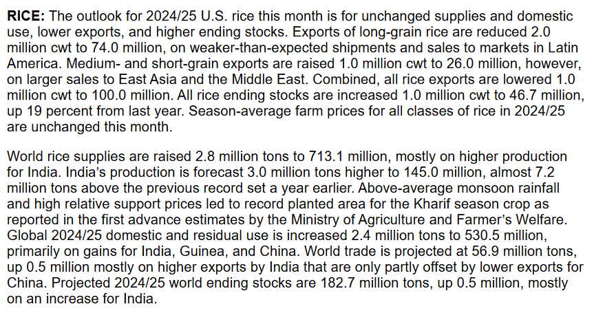
  • The Dow closed down 1 points or 0.00%, (Closed at 43,729, New Historic high 43,823)
  • Nasdaq closed up 286 points or 1.51%, (Closed at 19,269, New Historic high 19,302)
  • S&P 500 closed up 44 points or 0.74%, (Closed at 5,973, New Historic high 5,984)
  • Gold $2,712 up $36.30 or 1.33%,
  • WTI crude oil settled at $72 up $0.30 or 0.43%,
  • 10-year U.S. Treasury 4.332 down 0.094 points or 2.079%,
  • USD index $104.35 down $0.74 or 0.07%,
  • Bitcoin $76,510 up $390 or 0.51%, (24 Hours) , – New Bitcoin Historic high 76,874.36)

*Stock data, cryptocurrency, and commodity prices at the market closing

Today’s Highlights

The S&P 500 and Nasdaq Composite reached new record highs on Thursday, driven by a tech-led rally. This came as investors processed two major events – Federal Reserve interest rate cut and Donald Trump’s election victory: Trump’s win on Wednesday had already sent stock indices to record levels, with his proposed corporate tax cuts and deregulation fueling economic optimism. Nvidia and Amazon shares reached new all-time highs The Magnificent Seven stocks (Apple, Alphabet, Microsoft, Amazon, Meta, Tesla, and Nvidia) outperformed the broader market, with their ETF rising over 8% in the past five days compared to the S&P 500’s 4.69% gain. Fed Chair Jerome Powell addressed questions about the potential impact of Trump’s election on Fed policy, stating that in the near term, the election would not affect their decisions.


Click here to read our current Economic Forecast – November 2024 Economic Forecast: Our Index Marginally Declines – We Are Stuck With The Crappy Economy We Have Seen So Far This Year


Today’s Economic Releases Compiled by Steven Hansen, Publisher:

September 2024 sales of merchant wholesalers were down 0.4 percent (±0.9 percent)* from the revised September 2023 level. Total inventories of merchant wholesalers were up 0.3% from the revised September 2023 level. The September inventories/sales ratio for merchant wholesalers was 1.34. The September 2023 ratio was 1.33. Honestly, I am not sure why I consider this a significant release anymore. We need more wholesalers because companies have become only assemblers – and need to outsource more and more components. Combine this with more and more assemblers moving overseas – and this chaos makes understanding WTF is going on close to impossible.

In the week ending November 2, the advance figure for seasonally adjusted initial unemployment claims 4-week moving average was 227,250, a decrease of 9,750 from the previous week’s revised average. The previous week’s average was revised up by 500 from 236,500 to 237,000. No sign of recession in these numbers.

Nonfarm business productivity is up 2.0% year-over-year with costs up 3.4%. When costs rise faster than productivity, you are becoming less competitive. And honestly, the way productivity is calculated by the BLS is incorrect anyway. It takes a detailed analysis of each persons motion in a company and not a broad brush analysis of hours to produce a product. 

The Federal Reserve’s FOMC meeting concluded today with the expected 0.25 point reduction of the federal funds rate. The meeting statement:

Recent indicators suggest that economic activity has continued to expand at a solid pace. Since earlier in the year, labor market conditions have generally eased, and the unemployment rate has moved up but remains low. Inflation has made progress toward the Committee’s 2 percent objective but remains somewhat elevated.

The Committee seeks to achieve maximum employment and inflation at the rate of 2 percent over the longer run. The Committee judges that the risks to achieving its employment and inflation goals are roughly in balance. The economic outlook is uncertain, and the Committee is attentive to the risks to both sides of its dual mandate.

In support of its goals, the Committee decided to lower the target range for the federal funds rate by 1/4 percentage point to 4-1/2 to 4-3/4 percent. In considering additional adjustments to the target range for the federal funds rate, the Committee will carefully assess incoming data, the evolving outlook, and the balance of risks. The Committee will continue reducing its holdings of Treasury securities and agency debt and agency mortgage‑backed securities. The Committee is strongly committed to supporting maximum employment and returning inflation to its 2 percent objective.

In assessing the appropriate stance of monetary policy, the Committee will continue to monitor the implications of incoming information for the economic outlook. The Committee would be prepared to adjust the stance of monetary policy as appropriate if risks emerge that could impede the attainment of the Committee’s goals. The Committee’s assessments will take into account a wide range of information, including readings on labor market conditions, inflation pressures and inflation expectations, and financial and international developments.

According to the Federal Reserve, consumer credit increased in September at an annual rate of 1.4%. My take is that total consumer credit is up 2.2% year-over-year, nonrevolving credit (like car and student loans) is up 1.3% year-over-year, and revolving loans (say credit cards) is up 5.0% year-over-year. Revolving credit growth  continues to decline – and consider with inflation that the real growth of revolving credit is under 3%. There is no indication in these numbers that economic growth is constrained by credit availability.

Here is a summary of headlines we are reading today:

  • Duke Energy’s Hurricane Restoration Costs Could Hit $2.9 Billion
  • 17 Gulf Oil Platforms Evacuated Under Approach of Hurricane Rafael
  • Bank of England Cuts Interest Rates
  • Weaker U.S. Fracking Drags Halliburton Earnings Below Estimates
  • Big Oil CEOs Voice Concern Over Geopolitical Tensions
  • Fed meeting recap: Powell ‘feeling good’ about economy, says Trump can’t legally fire him
  • S&P 500, Nasdaq close at records and extend postelection rally as Fed cuts rates: Live updates
  • Airbnb stock up as revenue jumps
  • Rivian significantly misses Wall Street’s third-quarter revenue expectations
  • Former Treasury Secretary Mnuchin says Trump’s top priorities will be tax cuts, Iran sanctions and tariffs
  • The Federal Reserve cuts interest rates by a quarter point after election. Here’s what that means for you
  • Interest rates cut but Bank hints fewer falls to come
  • The bull market is ‘still an infant’: Why Evercore sees the S&P 500 at 6,600 by mid-2025
  • Powell sends one crystal clear message to Trump: Firing me is ‘not permitted under the law’

Click on the “Read More” below to access these, other headlines, and the associated news summaries moving the markets today.

Weather Outlook for the U.S. for Today Through at Least 22 Days and a Six-Day Forecast for the World: posted November 7, 2024

This article focuses on what we are paying attention to in the next 48 to 72 hours. The article also includes weather maps for longer-term U.S. outlooks (up to four weeks) and a six-day World weather outlook which can be very useful for travelers.

First the NWS Short Range Forecast. The afternoon NWS text update can be found here after about 4 p.m. New York time but it is unlikely to have changed very much from the morning update. The images in this article automatically update.

Short Range Forecast Discussion
NWS Weather Prediction Center College Park MD
351 AM EST
Valid 12Z Thu Nov 07 2024 – 12Z Sat Nov 09 2024

…Heavy snow expected to impact portions of Colorado and New Mexico while
heavy rain, severe weather, as well as increasingly windy conditions sweep
across the Southern Plains through the next couple of days…

…Heavy rain threat over the Southeast is expected to gradually diminish
by this evening…

…Hurricane Rafael is forecast to track more westward away from the
Florida Keys and into the Gulf Mexico through the next couple of days…

…Record warmth continues from the Mid-Atlantic down into the Southeast
and along the Gulf Coast…

Tropical moisture interacting with a disturbance under a broad channel of
southerly flow aloft has continued to produce heavy rainfall across the
Southeast this morning. The main dynamics associated with the disturbance
is forecast to track northeastward, allowing the heavy rain threat to
diminish by this evening as the disturbance tracks off the Carolina
coasts. WPC currently maintains a slight risk of heavy rain from eastern
Georgia into portions of South Carolina for today.

Farther south, tropical-storm-force winds and squally downpours associated
with rainbands from Hurricane Rafael were impacting the western portion of
the Florida Keys this morning. Rafael is forecast to track more toward
the west, allowing the tropical storm conditions over the Florida Keys to
gradually subside through the remainder of today.

Meanwhile, a winter storm continues to get organized across portions of
the central and southern Rockies and into the nearby High Plains. A
vigorous upper-level trough continues to plunge south and usher polar air
into the region while gradually develops a low pressure system over the
southern High Plains. The compact and vigorous nature of the upper low
will help sustain the snow in the general vicinity of Central/Southern
Rockies into the nearby High Plains (mostly within Colorado and New
Mexico) as the upper low rotates and lingers. If the upper low deepens
more than expected, the associated snow could linger in the same area
farther out in time. There is potential for a foot of snow to fall across
the Front Range of Colorado, while up to a few feet of wet snow is
possible farther south across the higher elevations near the Colorado-New
Mexico border and into northern New Mexico. Winter Storm Watches and
Warnings as well as Winter Weather Advisories have been expanded across
much of the aforementioned areas. In addition to producing snow, this
vigorous upper low could have changeable influences on the future track of
Rafael in the Gulf of Mexico. Please refer to NHC for the latest forecast
track on Rafael.

In addition to the heavy snow, this low pressure system will bring heavy
rain and severe weather farther east across the Southern Plains by later
today. The highest threat of heavy rain is forecast to be expanding
across western Texas toward southwestern Oklahoma tonight into Friday
morning when the low pressure system develops and intensifies over western
Texas as it tracks northward. A band of severe thunderstorms can also be
expected to sweep across western Texas ahead of a potent cold front. Much
of the central to southern High Plains will come under an increasing
threat of high winds as well especially by this evening into Friday
morning when the low pressure system deepens most rapidly. This could
result in gale force winds to accompany heavy snow on Friday across the
central High Plains in Colorado, while wind-swept rain impacts Oklahoma
and Kansas, and severe thundertorms sweep east across Texas ahead of the
potent cold front. By Saturday morning, much of the rain should be
pushing east into the Arklatex region and into the Central Plains ahead of
the low pressure system. This will allow the Southern Plains to dry out.
However, heavy snow could linger across central Colorado into Saturday
morning depending on the strength of the low pressure system.

Much colder temperatures are expected across the West behind the low
pressure system and a cold front; with 30s and 40s across the valleys and
dipping into the single digits in the cool spots for overnight lows. Make
sure to bundle up. Strong wind gusts along with lower moisture will
increase the risk for wildfires in the Southwest over the next few days.
Critical wildfire conditions persist across California where Red flag
warnings are in effect for portions of coastal and interior California.
The Storm Prediction Center has Critical Fire Conditions highlighted for
southern California with an extreme area in the vicinity of Santa Clarita
which will carry over for today. In contrast, record warm minimum
temperatures are forecast to continue from the Mid-Atlantic down into
theSoutheast and along the Gulf Coast through the next couple of nights.
High temperatures are not quite reaching record levels but will remain
well above normal for these areas for early November.

To get your local forecast plus active alerts and warnings click HERE and enter your city, state or zip code.

Learn about wave patterns HERE.

Then, looking at the world and of course, the U.S. shows here also. Today we are looking at precipitation.

Please click on “Read More” below to access the full Daily Report issued today.

06 NOV 2024 Market Close & Major Financial Headlines: Trump Win Ignites Markets To New Highs

Summary Of the Markets Today:

  • The Dow closed up 1,508 points or 3.57%, (Closed at 43,730, New Historic high 43,779)
  • Nasdaq closed up 544 points or 2.95%, (Closed at 18,983, New Historic high 19,005)
  • S&P 500 closed up 146 points or 2.53%, (Closed at 5,929, New Historic high 5,936)
  • Gold $2,669 down $8.10 or 2.94%,
  • WTI crude oil settled at $72 up $0.03 or 0.04%,
  • 10-year U.S. Treasury 4.441 up 0.153 points or 3.568%,
  • USD index $105.12 up $1.70 or 1.64%,
  • Bitcoin $75,993 up $7,326 or 9.64%, (24 Hours) , – New Bitcoin Historic high 76,355.00

*Stock data, cryptocurrency, and commodity prices at the market closing

Today’s Highlights

US stocks surged to record highs on Wednesday as investors reacted to Donald Trump’s victory in the presidential election over Kamala Harris. The decisive outcome dispelled anxieties about a potentially contested election and days of uncertainty. Key highlights: The Dow Jones Industrial Average jumped closing at a record high. The S&P 500 rose surpassing the 5,900 level for the first time. The Nasdaq Composite climbed also reaching a new record. The so-called “Trump trade” saw significant gains across various sectors: Financial stocks rallied, with the S&P Regional Banking ETF up over 11%. Tesla shares surged more than 14%, likely due to CEO Elon Musk’s support for Trump during the campaign. Bitcoin hit a record high above $75,000 before settling around $73,800. Bond yields also rose sharply, with the 10-year Treasury yield climbing, signaling expectations of higher inflation and interest rates under Trump’s policies. Beyond the presidential race, Republicans gained control of the Senate, though the House of Representatives outcome remains uncertain. Investors are now turning their attention to the Federal Reserve’s rate decision, expected on Thursday afternoon.


Click here to read our current Economic Forecast – November 2024 Economic Forecast: Our Index Marginally Declines – We Are Stuck With The Crappy Economy We Have Seen So Far This Year


Today’s Economic Releases Compiled by Steven Hansen, Publisher:

There were no releases today as the USA begins recovering from a brutal election cycle. Food for thought from Statista:

Infographic: Political Polarization Relatively Strong in the U.S. | Statista

You will find more infographics at Statista

Here is a summary of headlines we are reading today:

  • U.S. Sanctions Target Central Asian Firms for Aiding Russia’s War Effort
  • Trump’s Victory Signals a Shift in Global Power Dynamics
  • Rare Earth Prices Soar as Myanmar’s Mining Operations Halt
  • EIA Confirms Inventory Builds Across the Board
  • Bitcoin, Treasury Yields Jump as Trump Takes White House
  • Dow soars 1,500 points to record high in best day since 2022 after Trump election win: Live updates
  • The Fed is expected to cut interest rates again Thursday. Here’s everything you need to know
  • Trump promised no taxes on Social Security benefits. It’s too soon to plan on that change, experts say
  • Mortgage rates surge higher on Trump victory, causing housing stocks to fall
  • Yields Slide After Stellar 30Y Auction, But Then Blow Out Again
  • Bitcoin at record high above $75,000 is good news for Nifty bulls also. Here’s why
  • 30-year bond yield closes with biggest jump since 2022 after Trump wins
  • Oil prices end with a modest loss as Trump’s win lifts the dollar

Click on the “Read More” below to access these, other headlines, and the associated news summaries moving the markets today.

Weather Outlook for the U.S. for Today Through at Least 22 Days and a Six-Day Forecast for the World: posted November 6, 2024

This article focuses on what we are paying attention to in the next 48 to 72 hours. The article also includes weather maps for longer-term U.S. outlooks (up to four weeks) and a six-day World weather outlook which can be very useful for travelers.

First the NWS Short Range Forecast. The afternoon NWS text update can be found here after about 4 p.m. New York time but it is unlikely to have changed very much from the morning update. The images in this article automatically update.

Short Range Forecast Discussion
NWS Weather Prediction Center College Park MD
Wed Nov 06 2024
Valid 12Z Wed Nov 06 2024 – 12Z Fri Nov 08 2024

…Heavy rain threat emerging over the interior Southeast late today into
Thursday as tropical moisture associated with weak low over southeastern
Gulf of Mexico lifts northward...

…Increasing threat for heavy snow to impact the central to southern
Rockies and nearby High Plains through the next couple of days…

…Watching the Florida Keys for impacts associated with Hurricane Rafael
forecast to pass not far too to the west tonight…

…Record warmth expected for the Mid-Atlantic and southern New England
today…

As heavy rain threat across the Mississippi Valley gradually diminishes
today, tropical moisture associated with a weak low pressure circulation
centered over southeastern Gulf of Mexico is beginning to lift north
toward the Florida Panhandle under a broad channel of southerly flow
aloft. This weak low is a system somewhat separate from Hurricane Rafael
farther south in the Caribbean Sea. The tropical moisture associated with
the weak low is forecast to be drawn northward today, leading to heavy
rainfall tonight into Thursday morning across the interior section of the
Southeast. WPC currently places a moderate risk of heavy rain across
central Georgia into portions of South Carolina for this upcoming heavy
rain event. Meanwhile, moderate to locally heavy rain associated with a
cold front early this morning along the Mississippi and Ohio Valley early
this morning is forecast to become more scattered in nature as today
progresses.

Meanwhile, Hurricane Rafael continues to intensify over the northwestern
Caribbean Sea while heading northwest toward western Cuba. The National
Hurricane Center calls for Rafael to be a category-2 hurricane as it
passes not too far to the west of Key West tonight into Thursday morning.
Tropical Storm Warning is in effect for the western portion of the Florida
Keys where increasing winds with passing squally downpours associated with
rainbands from Rafael can be expected by tonight.

As Rafael threatens the Florida Keys, a winter storm is brewing across the
southern Rockies. A vigorous upper-level trough is plunging south toward
the Four Corners early this morning, ushering a surge of polar air into
the region while developing an area of snow over the central Rockies into
the central High Plains. The snow is expected to expand in coverage and
pickup intensity as today progresses. The compact and vigorous nature of
this upper low will help sustain the snow in the general vicinity of
central to southern Rockies into the nearby High Plains (mostly within
Colorado and New Mexico) as the upper low rotates and lingers. If the
upper low deepens more than expected, the associated snow could linger in
the same area farther out in time. There is potential for a foot of snow
to fall across the Front Range of Colorado, while a few feet of wet snow
is possible farther south across the higher elevations near the
Colorado-New Mexico border and into northern New Mexico. Winter Storm
Watches and Warnings as well as Winter Weather Advisories have been issued
for much of the aforementioned areas. In addition to producing snow, this
vigorous upper low could have changeable influences on the future track of
Rafael in the Gulf of Mexico. Please refer to NHC for the latest forecast
track on Rafael.

As arctic air plunges into the region temperatures will fall to the 30s
and 40s across the valleys and drop to the single digits in the cool spots
for overnight lows. Make sure to bundle up. Strong wind gusts along with
lower moisture will increase the risk for wildfires over the next few
days. Red flag warnings are in effect for portions of coastal and interior
California. The Storm Prediction Center has Critical Fire Conditions
highlighted for southern California today with an extreme area in the
vicinity of Santa Clarita which will carry over into Thursday. In
contrast, high temperatures are forecast to challenge or break records
today across the Mid-Atlantic into southern New England as well as
scattered locations in the South ahead of the weakening cold front moving
across the Mississippi Valley.

To get your local forecast plus active alerts and warnings click HERE and enter your city, state or zip code.

Learn about wave patterns HERE.

Then, looking at the world and of course, the U.S. shows here also. Today we are looking at precipitation.

Please click on “Read More” below to access the full Daily Report issued today.