Short Term and Intermediate-Term Weather Outlooks for the U.S. and a Six-Day Forecast for the World: posted September 17, 2023

Here is what we are paying attention to in the next 48 to 72 hours. The article also includes weather maps for longer-term outlooks and a six-day World weather outlook.

We start with the U.S. Information. You can update this section here but these are 48 to 72-hour forecasts so if I have not been able to update this area twice daily, what is shown is still valid and the images in the body of the article update automatically but sometimes they are a bit slow to update.

Short Range Forecast Discussion
NWS Weather Prediction Center College Park MD
319 PM EDT Sun Sep 17 2023
Valid 00Z Mon Sep 18 2023 – 00Z Wed Sep 20 2023

…Shower and storm chances along the East Coast confine to New England on
Monday…

…Unsettled weather and severe storm chances return to parts of the
Southern Plains on Tuesday…

…Much above average high temperatures spread from the Northern Rockies
to the Northern Plains early this week…

Eight Dancing Queens & Kings at USDC 2023

Eight Dancing Queens & Kings at USDC 2023

In a previous post (Dancing Queens & Kings: Call for Participation (4)), I highlighted eight dancing queens or kings as examples (age-group):

  • Linda Gill (S2).
  • Kristin Franceschi (S1).
  • Lou Nielson (S1).
  • Giovanni Fortezza (C).
  • Nichelle Kennedy (C).
  • Sara Granberg (B).
  • Alexis Salapatek (A).
  • Frank Li (S1).

Now, let me highlight how they did at USDC 2023 last week (9/4-10).

Looking Back at the Global Climate in August 2023 – This past August was the Warmest August on Record. But it was More Than That – September 16, 2023

Every month, John Bateman sends me a nice email. Usually, he sends me two: one about the U.S. and one about the world.  I do not recall receiving an email from him on the U.S. but I published my own article on August in the U.S. and you can find it HERE. Yesterday he sent me the email for the world. Since they are emails, I usually can not provide a link to what he sent me. He is a spokesperson (not sure that is the right description of his job) for NOAA both NCEI and other parts of NOAA.  For this monthly article, all of the information in his email comes from the NOAA National Centers for Environmental Information so the information he includes in his email and much more can be found HERE. I published his article in full but included two additional graphics from NCEI namely the historical year by year record and the map of important events.

Obviously the headline this month is that August has been the warmest August since this data has been collected.  And it was also the fifth consequtive month of record ocean surface temperatures.


This is the record of August land and ocean temperature anomalies and this Augugust appears to have set a new record high. It is just speculation on my part but I think it is the stepwise rise in temperature we get with an El Nino. But some believe that other factors were a larger contributor to this in August and also in July than simply the increase in greenhouse gases. They may be correct in that many factors impact temperature and precipitation. In this article, we report what happened rather than try to explain why it happened. “Attribution” is always very complex.


Short Term and Intermediate-Term Weather Outlooks for the U.S. and a Six-Day Forecast for the World: posted September 16, 2023 – Hurricane Lee Arrives

It is now Post-Tropical Cyclone Lee rather than Hurricane Lee with the change occurring right after I published so I could not change the title of the article.

Here is what we are paying attention to in the next 48 to 72 hours. The article also includes weather maps for longer-term outlooks and a six-day World weather outlook.

We start with the U.S. Information. You can update this section here but these are 48 to 72-hour forecasts so if I have not been able to update this area twice daily, what is shown is still valid and the images in the body of the article update automatically but sometimes they are a bit slow to update.

Short Range Forecast Discussion
NWS Weather Prediction Center College Park MD
Sat Sep 16 2023
Valid 12Z Sat Sep 16 2023 – 12Z Mon Sep 18 2023

…Tropical storm conditions for coastal New England today as Lee tracks
by…

…Shower and storm chances this weekend from the Southern Plains to the
Southeast/Mid-Atlantic with some locally heavy rainfall possible…

…Much above average highs expected for the Pacific Northwest/Northern
Rockies this weekend with a Critical Risk of Fire Weather Saturday…

cone graphic

[Key Messages]

15 Sept 2023 Market Close & Major Financial Headlines: Dow Lost All But 30 Points From Yesterday’s Gains, Some Investors Are Blaming The UAW Auto Strike

Summary Of the Markets Today:

  • The Dow closed down 289 points or 0.83%,
  • Nasdaq closed down 1.56%,
  • S&P 500 closed down 1.22%,
  • Gold $1,944 up $11.60,
  • WTI crude oil settled at $91 up $0.96,
  • 10-year U.S. Treasury 4.328% up 0.038 points,
  • USD Index $105.34 down $0.070,
  • Bitcoin $26,405 down $279,
  • Baker Hughes Rig Count: U.S. +9 to 641 Canada +8 to 190

*Stock data, cryptocurrency, and commodity prices at the market closing.


Click here to read our Economic Forecast for September 2023


Today’s Economic Releases Compiled by Steven Hansen, Publisher:

U.S. import prices are down 3.0% year-over-year whilst export prices are down 5.5% year-over-year. This deflation was caused by over-aggressive price increases a year ago.

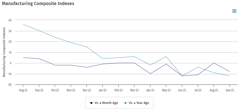
The September 2023 Empire State Manufacturing Survey rose twenty-one points to 1.9. Manufacturing has been in a recession. This index jumping 21 points in one month is not believable.

Industrial production increased 0.2 percent year-over-year in August 2021 – year -over-year growth in sub-components manufacturing, mining, and utilities rose -0.6, 3.9, and 1.2 year-over-year respectively. Capacity utilization moved up to 79.7 percent in August, in line with its long-run (1972–2022) average. Manufacturing remains in a recession.

University of Michigan consumer sentiment inched down a scant 1.8 index points this month and has been essentially flat for the past two months. At 67.7 points, sentiment is currently about 35% above the all-time historic low reached in June of 2022 but remains shy of the historical average reading of 86.


Here is a summary of headlines we are reading today:

  • Yen’s Dramatic Slide Triggers Unexpected Gold Rush In Japan
  • U.S. Drilling Activity Ticks Up As Oil Prices Rise
  • Gas Markets Stabilize As Freeport LNG Roars Back To Full Power
  • Historic Strike Hits Big Three Automakers Hard
  • The Oil Price Rally Is Fueling Inflation Concerns
  • Dow sheds nearly 300 points Friday, S&P 500 and Nasdaq suffer second straight week of losses: Live updates
  • Uranium Prices Hit A 12-Year High
  • Futures Movers: Oil futures mark a new high for the year, up a third straight week
  • Commodities Corner: Consumers take notice as inflation bites and oil prices top $90 a barrel
  • Chip-equipment stocks drop following reported TSMC setback, but analysts see buying opportunity

Click on the “Read More” below to access these, other headlines, and the associated news summaries moving the markets today.

NOAA Updates its ENSO Alert on September 14, 2023 – The El Nino Advisory Continues. In a Week, NOAA Will Update us on how this Impacts U.S. Weather

On the second Thursday of every month, NOAA (really their Climate Prediction Center CPC) issues its analysis of the status of ENSO. This includes determining the Alert System Status.  NOAA again describes their conclusion as “ENSO Alert System Status: El Nino Advisory”

There is not much doubt that we have an El Nino. How long it lasts and its strength remains to be seen. NOAA may be more conservative compared to some other Weather Advisory Organizations.

CLIMATE PREDICTION CENTER ENSO DISCUSSION

The second paragraph is what is important:

“The most recent IRI plume indicates El Niño will persist through the Northern Hemisphere winter 2023-24.  Despite nearly the same ensemble mean amplitude as last month, the shorter forecast horizon means that the odds of at least a “strong” El Niño (≥1.5C for the November-January seasonal average in Niño-3.4) have increased to 71%.  However, a strong El Niño does not necessarily equate to strong impacts locally, with the odds of related climate anomalies often lower than the chances of El Niño itself (e.g., CPC’s seasonal outlooks).  In summary, El Niño is anticipated to continue through the Northern Hemisphere winter (with greater than 95% chance through January – March 2024; ).”

We now provide additional detail but I am keeping this article shorter than usual because nothing much has changed since last month.

CPC Probability Distribution

Here are the new forecast probabilities. This information in the past has been released twice a month and the first release is based on a survey of Meteorologists, the second is based on model results. The probabilities are for three-month periods e.g. ASO stands for August/September/October. The approach may have changed as IRI (The International Research Institute for Climate and Society, Columbia University Climate School) may no longer be involved.  Their website has not been updated this month.

Here is the current release of the probabilities:

You can clearly see the forecast does not extend beyond AMJ 2024 and one does see a tail-off in the probabilities for El Nino conditions in the Eastern Pacific after the winter season.  Some Meteorological Agencies see El Nino lasting longer but JAMSTEC showed it ending sooner in the article I posted last night which you can access HERE.

Here is the forecast from late last month.

This showed a slower demise of the El Nino.

Select Short Term and Intermediate-Term Weather Outlooks for the U.S. and a Six-Day Forecast for the World: posted September 15, 2023 – Hurricane Lee is Still a Factor

Here is what we are paying attention to in the next 48 to 72 hours. The article also includes weather maps for longer-term outlooks and a six-day World weather outlook.

We start with the U.S. Information. You can update this section here but these are 48 to 72-hour forecasts so if I have not been able to update this area twice daily, what is shown is still valid and the images in the body of the article update automatically but sometimes they are a bit slow to update.

Short Range Forecast Discussion
NWS Weather Prediction Center College Park MD
Fri Sep 15 2023
Valid 12Z Fri Sep 15 2023 – 12Z Sun Sep 17 2023

…Lee continues tracking north, tropical storm and hurricane conditions
possible for coastal New England Friday and Saturday…

…Heavy rain and strong storms likely over the Southern Plains Friday…

…Dry conditions in the West with some much above average highs expected
for the Pacific Northwest/Northern Rockies this weekend...
cone graphic

[Key Messages]

14 Sept 2023 Market Close & Major Financial Headlines: Wall Street Rallies On Improved Economic Data, Dow Closes Above 330 points

Summary Of the Markets Today:

  • The Dow closed up 332 points or 0.96%,
  • Nasdaq closed up 0.81%,
  • S&P 500 closed up 0.84%,
  • Gold $1,931 down $1.50,
  • WTI crude oil settled at $90 up $1.81,
  • 10-year U.S. Treasury 4.290% up 0.042 points,
  • USD Index $105.37 up $0.600,
  • Bitcoin $26,663 up $468,

*Stock data, cryptocurrency, and commodity prices at the market closing.


Click here to read our Economic Forecast for September 2023


Today’s Economic Releases Compiled by Steven Hansen, Publisher:

Advance estimates of U.S. retail and food services sales for August 2023 were up 2.5% (blue line on the graph below) above August 2022 – up 0.9% year-over-year inflation-adjusted (red line on the graph below). It was gasoline sales that accounted for the modest increase year-over-year over last month.

The Producer Price Index for final demand rose 1.6 percent for the 12 months ended in August 2023 (blue line on the graph below). In August, 80 percent of the rise in final demand prices is attributable to a 2.0 percent jump in the index for final demand goods (green line on the graph below). For the 12 months ended in August, prices for final demand less foods, energy, and trade services rose 3.0 percent, the largest advance since moving up 3.4 percent for the 12 months ended in April. I expect inflation pressures to grow through the rest of the year.

In the week ending September 9, the advance figure for seasonally adjusted initial unemployment claims 4-week moving average was 224,500, a decrease of 5,000 from the previous week’s revised average. The previous week’s average was revised up by 250 from 229,250 to 229,500.

Here is a summary of headlines we are reading today:

  • The Future Of Lithium-ion Battery Recycling
  • European Central Bank Surprises Markets With Rate Hike
  • Rising Gasoline Prices Push August Consumer Price Index Higher
  • OPEC Slams The IEA Over Peak Fossil Fuel Demand Claims
  • Dow jumps 300 points for best day since early August as Arm debut revives IPO market hopes: Live updates
  • Everything you need to know about UAW’s targeted strike plans – and possible lockouts
  • Hunter Biden indicted on firearms charges
  • SoftBank’s Masayoshi Son says AI-fueled technology can surpass human intelligence ‘big time’
  • August wholesale inflation rises 0.7%, hotter than expected, but core prices in check
  • Manhattan median rent remains at record high of nearly $4,400 a month
  • Dollar hits 6-month high after data, ECB announcement
  • Market Extra: Triple witching day: analysts brace for volatility as $3.4 trillion in stock options set to expire Friday

Click on the “Read More” below to access these, other headlines, and the associated news summaries moving the markets today.

Our Report on the JAMSTEC Three-Season Weather Forecast – September 14, 2023

The Japan Agency for Marine-Earth Science and Technology, or JAMSTEC, is a Japanese national research institute for marine-earth science and technology

From the JAMSTEC Discussion:

As predicted, the recent observation confirms the occurrence of the El Niño. The SINTEX-F ensemble mean predicts that the El Niño will reach its peak in the late boreal autumn and persist at least until the next boreal spring. However, there is a large uncertainty in the predicted amplitude.

Although it is a World forecast, it includes a forecast for North America since North America is part of the World. The JAMSTEC discussion does not address it but the maps show the U.S. being an area that has a lot of area that is not warmer than Climatology which I interpret as a fairly cold winter but surprisingly dry in the Southwest.

First, we take a look at the forecasted sea surface temperature anomalies (SSTA). JAMSTEC starts by forecasting the SSTA and Nino 3.4 Index on the first day of the month and from there it usually takes their models about two weeks to produce their seasonal forecast. I received it from JAMSTEC on September 12, 2023 which is a week earlier than when we will receive the Seasonal Outlook from NOAA which will be on September 21.  The JAMSTEC model runs are based on conditions as of September 1, 2023. The NOAA Seasonal Outlook will be based on conditions closer to the time when it is issued.


Short Term and Intermediate-Term Weather Outlooks for the U.S. and a Six-Day Forecast for the World: posted September 14, 2023 – Hurricane Lee is Still a Factor

Here is what we are paying attention to in the next 48 to 72 hours. The article also includes weather maps for longer-term outlooks and a six-day World weather outlook.

We start with the U.S. Information. You can update this section here but these are 48 to 72-hour forecasts so if I have not been able to update this area twice daily, what is shown is still valid and the images in the body of the article update automatically but sometimes they are a bit slow to update.

Short Range Forecast Discussion
NWS Weather Prediction Center College Park MD
Thu Sep 14 2023
Valid 12Z Thu Sep 14 2023 – 12Z Sat Sep 16 2023

….As Lee continues to track north, tropical storm conditions are
possible across a large portion of coastal New England beginning Friday
night…

…Life-threatening storm surge flooding possible in portions of
southeastern Massachusetts beginning late Friday…

…Unsettled weather, with heavy rain and strong storms possible, to
continue into the weekend over the southern Plains…

cone graphic