Weather Outlook for the U.S. for Today Through at Least 22 Days and a Six-Day Forecast for the World: – Posted on January 7, 2025
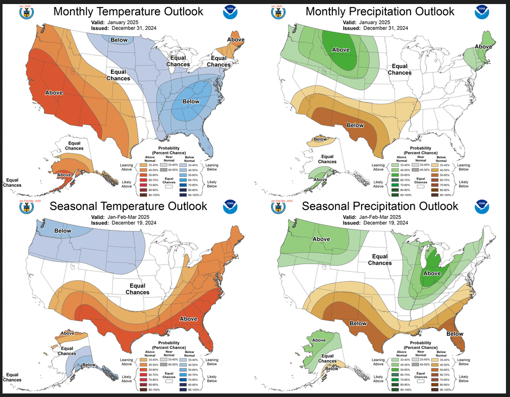
This article focuses on what we are paying attention to in the next 48 to 72 hours. The article also includes weather maps for longer-term U.S. outlooks (up to four weeks) and a six-day World weather outlook which can be very useful for travelers.
First the NWS Short Range Forecast. The afternoon NWS text update can be found here after about 4 p.m. New York time but it is unlikely to have changed very much from the morning update. The images in this article automatically update.
Short Range Forecast Discussion
NWS Weather Prediction Center College Park MD
Tue Jan 07 2025
Valid 12Z Tue Jan 07 2025 – 12Z Thu Jan 09 2025…Moderate to heavy lake-effect snow downwind from the Great Lakes on
Tuesday and Wednesday……A Developing Winter Storm will produce snow and rain/freezing rain,
icing, over parts of Texas on Wednesday……Light snow over parts of the Great Basin, Southwest, and
Central/Southern Rockies on Tuesday and over the Northern Rockies/Northern
High Plains on Wednesday……There is a Critical Risk of fire weather over parts of Southern
California on Tuesday and Wednesday, with an Extremely Critical Risk for
portions of Los Angeles and Ventura counties on Wednesday…Cold high pressure over the Northern High Plains will move southeastward
to the Ohio Valley by Thursday. The cold air and upper-level energy will
aid in producing moderate to heavy lake-effect snow downwind from the
Great Lakes through Thursday. In addition, moderate to heavy upslope snow
will develop over parts of Northern New England, and light to moderate
upslope snow over the Central Appalachians will develop through Thursday.Meanwhile, strong high pressure will develop over parts of the Great
Basin, setting up Santa Ana winds over Southern California on Tuesday,
that will continue into Wednesday. Therefore, the SPC has issued a
Critical Risk Fire Weather Outlook over parts of Southern California on
Tuesday and Wednesday, with an Extremely Critical Outlook for portions of
Los Angeles and Ventura counties on Wednesday. Winds of 20 to 25 mph on
Tuesday, increasing up to 40 mph on Wednesday, with stronger gusts in
terrain-favored areas, along with low relative humidity, and dry fuels
will contribute to dangerous conditions.Moreover, on Tuesday, upper-level energy over Southern California will
move southward to Northwestern Mexico, creating a deep upper low over the
region by Wednesday. The energy will begin to move eastward over Northern
Mexico by Thursday. By Tuesday morning, light to moderate snow will
develop over parts of the Great Basin and the Northern/Central Rockies.
Light to moderate snow will develop over parts of the Southern Rockies by
Tuesday evening.The system will produce light snow over West Texas on Wednesday before a
more significant storm on Thursday. Many areas from northern Texas,
including the Dallas-Fort Worth Metroplex, will have at least some chance
(>30%) of wintry weather. With cold air already in place, a wintry mix of
snow, sleet, and freezing rain is forecast for the Southern Plains, which
may cause hazardous driving conditions, starting late Wednesday night and
continuing into Thursday morning.Further, additional upper-level energy will move over the Pacific
Northwest Wednesday morning and reach the Central Rockies by Thursday,
aiding in the development of a new front from the Northern/Central Plains
into the Central Rockies. The new energy will create a short-lived light
coastal rain and higher-elevation snow over parts of the Pacific Northwest
on early Wednesday morning. By Wednesday evening, light snow will develop
over parts of the Northern Rockies, expanding into parts of the Northern
Plains and Central Rockies by Thursday.
To get your local forecast plus active alerts and warnings click HERE and enter your city, state or zip code.