Today Through the Fourth Friday (22 to 28 days) Weather Outlook for the U.S. and a Six-Day Forecast for the World: posted April 21, 2024

It is difficult to find a more comprehensive Weather Outlook anywhere else with the ability to get a local 10-day Forecast also.

This article focuses on what we are paying attention to in the next 48 to 72 hours. The article also includes weather maps for longer-term U.S. outlooks and a six-day World weather outlook which can be very useful for travelers.

First the NWS Short Range Forecast. The afternoon NWS text update can be found here but it is unlikely to have changed very much. The images in this article automatically update.

Short Range Forecast Discussion
NWS Weather Prediction Center College Park MD
Sun Apr 21 2024
Valid 12Z Sun Apr 21 2024 – 12Z Tue Apr 23 2024

…Lingering showers and storms expected across the Southeast today and
Florida through Monday…

…Above average temperatures forecast throughout the Southwest, with
below average readings for most locations east of the Rockies…

Strong high pressure over the central U.S. today is set to slide eastward
by early this week and will allow for mostly tranquil weather conditions
across the Nation. A lingering frontal boundary along the Southeast will
produce additional scattered showers and thunderstorms through tonight
across the Carolinas, Georgia, and northern Florida. Rainfall amounts are
expected to remain mostly light as the activity quickly races to the east,
with rainfall chances on Monday confined to the Florida Peninsula. As the
aforementioned frontal boundary crosses central Florida to start the new
workweek, a few storms could strengthen enough to contain damaging wind
gusts and hail. The Storm Prediction Center has issued a Marginal Risk
(level 1/5) for severe weather across parts of the central and southern
Florida Peninsula in order to highlight this potential.

Outside of a few rain and snow showers across New England associated with
an approaching cold front on Sunday night, the only other areas with
notable precipitation will be linked to a low pressure system and attached
cold front stretching from the Upper Great Lakes to the central Plains
Monday night. Rainfall amounts are expected to remain meager and mostly
under a half inch through Tuesday as the system swings into Midwest and
Ohio Valley.

Temperatures across the country will remain split today, with warmth in
the Southwest and cooler than average highs across the central and eastern
United States. As high pressure weakens and slides east, a gradual warm up
can be expected east of the Rockies. The greatest turnaround is
anticipated over the southern Plains, where highs in the 60s today could
be replaced by 80s on Tuesday. Meanwhile, lows into the 20s and 30s this
morning are likely to lead to frost/freeze concerns throughout the Midwest
and parts of the Ohio Valley. Chilly morning temperatures are also
expected to linger on Monday, before cool weather erodes to the Northeast
on Tuesday with portions the Appalachians, Mid-Atlantic, and Northeast
waking up to frosty temperatures in the 30s.

To get your local forecast plus active alerts and warnings click HERE and enter your city, state or zip code.

Learn about wave patterns HERE.

Then, looking at the world and of course, the U.S. shows here also. Today we are looking at precipitation.

Please click on “Read More” below to access the full Daily Report issued today.

Today Through the Fourth Friday (22 to 28 days) Weather Outlook for the U.S. and a Six-Day Forecast for the World: posted April 20, 2024

It is difficult to find a more comprehensive Weather Outlook anywhere else with the ability to get a local 10-day Forecast also.

This article focuses on what we are paying attention to in the next 48 to 72 hours. The article also includes weather maps for longer-term U.S. outlooks and a six-day World weather outlook which can be very useful for travelers.

First the NWS Short Range Forecast. The afternoon NWS text update can be found here but it is unlikely to have changed very much. The images in this article automatically update.

Short Range Forecast Discussion
Sat Apr 20 2024
Valid 12Z Sat Apr 20 2024 – 12Z Mon Apr 22 2024

…Heavy rain and scattered instances of flash flooding possible across
the southern Plains and lower Mississippi Valley today…

…Light snow continues across parts of the central Rockies and central
High Plains…

…Below average temperatures for much of the Nation east of the Rockies
this weekend before spring warmth returns to the Plains on Monday…

A lingering quasi-stationary front draped across the Southeast, Gulf Coast
States, and southern Plains will be the focus for numerous showers and
thunderstorms this weekend. The greatest impacts associated with this
system are expected to occur today as heavy rain could lead to scattered
flash flooding issues from Texas to Mississippi. Multiple rounds of
potentially intense rainfall developing over saturated terrain has
prompted a Slight Risk (level 2/4) of Excessive Rainfall through tonight.
This area includes much of central and eastern Texas, northern Louisiana,
southern Arkansas, and central Mississippi. A few isolated storms could
also contain damaging wind gusts and hail throughout central/southern
Texas and the Southeast. The greatest coverage of showers and
thunderstorms are expected to progress eastward tonight and eventually
confine to the central Gulf Coast and Southeast on Sunday, with lessening
chances for flash flooding and severe thunderstorms.

Light precipitation chances are also forecast to continue across other
parts of the Nation through Monday. Light snow will linger throughout
parts of Colorado today, where a few additional inches of accumulating
snowfall are expected along the Front Range. Winter Weather Advisories
remain in effect. Meanwhile, an exiting cold front today followed by a
stronger cold front on Sunday night will lead to rain and snow showers
traversing New England. Lastly, the next frontal system to impact the
Pacific Northwest will rapidly spread showers throughout the region
tonight before swiftly pushing rain chances into the northern Plains and
Upper Midwest on Monday.

Temperatures are anticipated to remain below average for much of the
country behind the cold front extending from the Southeast to the southern
Plains. This leaves the West, Southwest, and Southeast as the warm spots
this weekend with highs into the 70s and 80s. As temperatures moderate on
Monday and return flow enters the central U.S., below normal temperatures
are expected to erode as highs into the 70s surge into the central Plains,
with cooler weather remaining across the Northeast. Additionally, lows
into the 30s over the next few mornings could lead to frost/freeze
concerns for locations already in the growing season from the Midwest to
the upper Ohio Valley.

To get your local forecast plus active alerts and warnings click HERE and enter your city, state or zip code.

Learn about wave patterns HERE.

Then, looking at the world and of course, the U.S. shows here also. Today we are looking at precipitation.

Please click on “Read More” below to access the full Daily Report issued today.

NOAA Updates its Seasonal Outlook on April 18, 2024 – La Nina is Coming: Published April 19, 2024

On the third Thursday of the month right on schedule NOAA issued their updated Seasonal Outlook which I describe as their Four-Season Outlook because it extends a bit more than one year into the future. The information released also included the Mid-Month Outlook for the following month plus the weather and drought outlook for the next three months.  I present the information issued by NOAA and try to add context to it. It is quite a challenge for NOAA to address the subsequent month, the subsequent three-month period as well as the twelve successive three-month periods for a year or a bit more.

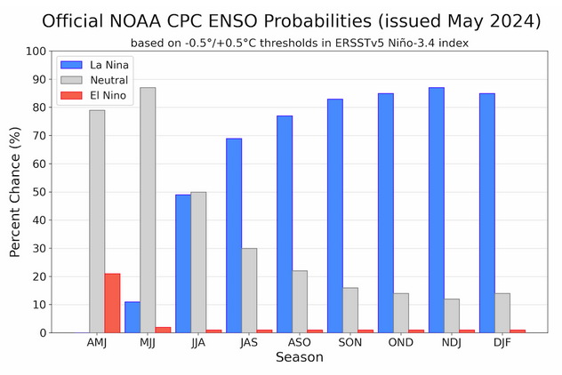
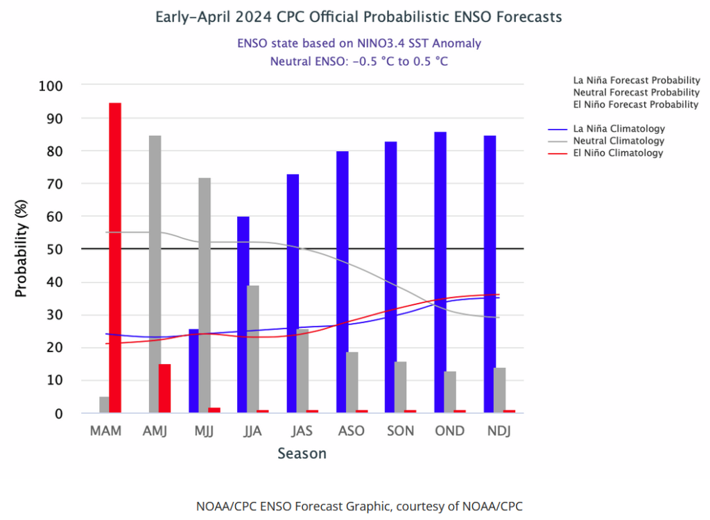
With respect to the long-term part of the Outlook which I call the Four-Season Outlook, there is a rapid transition from El Nino to ENSO Neutral to LaNina. So getting the timing right is challenging. La Nina is now the likely scenario for this summer almost to the end of the forecast period. The Outlook beyond May has not been significantly changed from what was issued last month. This suggests increasing confidence in the outlook.  I may write another article on the implications of this forecast for agriculture and perhaps energy usage.

First, Let’s Take a Look at the (mid-month) Outlook for May

It will be updated on the last day of April.

The top row is what is now called the Mid-Month Outlook for next month which will be updated at the end of this month. There is a temperature map and a precipitation map. The second row is a three-month outlook that includes next month.  I think the outlook maps are self-explanatory. What is important to remember is that they show deviations from the current definition of normal which is the period 1991 through 2020.  So this is not a forecast of the absolute value of temperature or precipitation but the change from what is defined as normal or to use the technical term “climatology”.

Notice that the Outlook for next month and the three-month Outlook are somewhat different, especially with regard to temperature.  This tells us that June and July will be different than May to some extent.

The full NOAA Seasonal Outlook extends through May/June/July of 2025 (yes that is more than a year out). All of these maps are in the body of the article. Large maps are provided for May and the three-month period May/June/July.  Small maps are provided beyond that through May/June/July of 2025 with a link to get larger versions of these maps.

NOAA provides an excellent discussion to support the maps. It is included in the body of this article. In some cases, one will need to click on “read more” to read the full article.  For those on my email list where I have sent the url of the article, that will not be necessary.

Today Through the Fourth Friday (22 to 28 days) Weather Outlook for the U.S. and a Six-Day Forecast for the World: posted April 19, 2024

It is difficult to find a more comprehensive Weather Outlook anywhere else with the ability to get a local 10-day Forecast also.

This article focuses on what we are paying attention to in the next 48 to 72 hours. The article also includes weather maps for longer-term U.S. outlooks and a six-day World weather outlook which can be very useful for travelers.

First the NWS Short Range Forecast. The afternoon NWS text update can be found here but it is unlikely to have changed very much. The images in this article automatically update.

Short Range Forecast Discussion
NWS Weather Prediction Center College Park MD
Fri Apr 19 2024
Valid 12Z Fri Apr 19 2024 – 12Z Sun Apr 21 2024

…Scattered showers and thunderstorms push into the central/southern
Appalachians and Southeast today…

…Wet snow and wintry mix over the central High Plains on Saturday as
heavy rain threat develops over parts of Texas and the lower Mississippi
Valley…

…Unseasonably warm across much of the South and Southwest as below
average temperatures expand throughout the Great Plains and Midwest…

The main weather feature and focus for showers and thunderstorms through
this weekend will be a cold front progressing across the East and stalling
between the Southeast and southern Texas. Unsettled weather will start the
short range forecasting period located across the central/southern
Appalachians and Southeast. These locations will have the greatest chances
for isolated thunderstorms to become strong enough to produce locally
damaging wind gusts and hail. Elsewhere, light showers are expected to
extend into the Northeast through tonight.

Precipitation is also expected to become more widespread and increase in
intensity throughout the central High Plains and Colorado Front Range by
tonight. A mix of rain and snow is likely, with heavy snow (greater than 4
inches) most likely along the Front Range and lesser amounts into the
foothills on eastward into the High Plains. Snow chances should gradually
subside by Saturday evening, but chilly temperatures will remain across
much of the Great Plains on Sunday.

Meanwhile, instances of heavy rain and scattered flash flooding are
possible on Saturday across parts of the southern Plains and lower
Mississippi Valley as numerous showers and embedded thunderstorms develop
to the north of a stationary front. Repeating rounds of intense rainfall
and areas with wet antecedent ground conditions have prompted a Slight
Risk (level 2/4) of Excessive Rainfall between central Texas and the
ArkLaMiss region. Fortunately, this system is forecast to quickly exit to
the east on Sunday and shift shower and thunderstorm chances to the
Southeast, limiting the flooding threat somewhat.

A quick-moving system will also swing light precipiation into the
Northwest this weekend, which will continue to promote above average
temperatures over the Southwest. Spring warmth will also be found
throughout much of the South today and Saturday for places avoiding
afternoon rain. For a majority of the Nation; however, well below average
temperatures will remain locked in place this weekend underneath high
pressure streaming in from Canada. Highs are anticipated to range from the
40s in the northern Plains and Upper Midwest to the 60s from the
Mid-Atlantic to the Tennessee Valley. Lows into the 30s could produce
frost and/or freeze conditions in the Midwest as well.

To get your local forecast plus active alerts and warnings click HERE and enter your city, state or zip code.

Learn about wave patterns HERE.

Then, looking at the world and of course, the U.S. shows here also. Today we are looking at precipitation.

Please click on “Read More” below to access the full Daily Report issued today.

Today Through the Fourth Friday (22 to 28 days) Weather Outlook for the U.S. and a Six-Day Forecast for the World: posted April 18, 2024

It is difficult to find a more comprehensive Weather Outlook anywhere else with the ability to get a local 10-day Forecast also.

This article focuses on what we are paying attention to in the next 48 to 72 hours. The article also includes weather maps for longer-term U.S. outlooks and a six-day World weather outlook which can be very useful for travelers.

First the NWS Short Range Forecast. The afternoon NWS text update can be found here but it is unlikely to have changed very much. The images in this article automatically update.

Short Range Forecast Discussion

Short Range Forecast Discussion
NWS Weather Prediction Center College Park MD
Thu Apr 18 2024
Valid 12Z Thu Apr 18 2024 – 12Z Sat Apr 20 2024

…Severe weather and isolated flash flooding for the Middle
Mississippi/Lower Ohio Valleys and Southern Plains Thursday…

…Showers, thunderstorms, and cooler weather for much of the Southern
Plains Friday; wintry mix into the central High Plains…

…Unseasonably warm conditions for much of the southern U.S.; chillier
weather expands across the northern Rockies/Plains and Upper Midwest…

A weakening system over the Northeast will bring some shower chances to
the northern Mid-Atlantic into New England Thursday. To the west, a much
broader area of showers and thunderstorms is expected ahead of a cold
front from the Middle Mississippi/Lower Ohio Valleys southwestward through
the Southern Plains. Sufficient shear and instability will be in place in
the Middle Mississippi/Lower Ohio Valleys for some organized
thunderstorms/line segments, with the Storm Prediction Center noting an
Enhanced Risk (level 3/5) for severe weather. Very large hail, damaging
winds, and a few tornadoes will all be possible. A Slight Risk (level 2/5)
extends southwestward along the front into Texas, with a more isolated
threat for some large hail and damaging winds. The prospect of widespread
storm coverage, especially for areas further north through the Middle
Mississippi Valley, and the potential for heavy downpours may lead to some
isolated flash flooding as well.

Shower and thunderstorm chances will progress eastward with the advancing
cold front into the Appalachians by Friday morning and eventually the East
Coast by Friday evening, though coverage and intensity looks to trend
downward during the day as the front approaches the coast. A few isolated
severe thunderstorms may occur over the Southeast. Areas of moderate to
rainfall will linger over portions of the Southern Plains along and north
of the cold front over Texas as it begins to slow and stall over the
region. Some isolated flooding will be possible. Post-frontal upslope flow
will also bring precipiation chances to the central High Plains and Front
Range of the Rockies, with a mix of rain and snow showers for lower
elevations and snow into the mountains. Any accumulations at the lower
elevations should remain minimal.

Forecast high temperatures remain rather warm to even hot across southern
portions of the country Thursday, with highs in the mid-80s to near 90
from Texas eastward through the Southeast, and even as far north as
portions of the Middle Mississippi and Lower Ohio Valleys. Areas of west
Texas and along the Rio Grande Valley will see mid- to upper 90s.
Conditions will be similarly hot in the Desert Southwest. The southerly
progression of the cold front will bring much cooler temperatures Friday
across northern Texas and into the Mid-South and Tennessee Valley as highs
drop into the 60s and 70s. Conditions will remain hot south of the frontal
boundary. Further north, highs will range in the 50s and 60s across the
central Plains northeastward into the Great Lakes region, with 60s and 70s
from the Ohio Valley into the southern Mid-Atlantic. The northern
Mid-Atlantic into New England will be a bit chilly Thursday with highs in
the 40s and 50s, with temperatures expected to recover a bit Friday. Cold
temperatures will also expand in coverage across the northern
Rockies/Plains and Upper Midwest as high pressure settles in over the
region, with highs in the 30s and 40s. In the West, highs will range from
the 60s and 70s from the Pacific Northwest southward through coastal
California and inland across the Great Basin, with 80s for the central
California valleys.

To get your local forecast plus active alerts and warnings click HERE and enter your city, state or zip code.

Learn about wave patterns HERE.

Then, looking at the world and of course, the U.S. shows here also. Today we are looking at precipitation.

Please click on “Read More” below to access the full Daily Report issued today.

Today Through the Fourth Friday (22 to 28 days) Weather Outlook for the U.S. and a Six-Day Forecast for the World: posted April 17, 2024

It is difficult to find a more comprehensive Weather Outlook anywhere else with the ability to get a local 10-day Forecast also.

This article focuses on what we are paying attention to in the next 48 to 72 hours. The article also includes weather maps for longer-term U.S. outlooks and a six-day World weather outlook which can be very useful for travelers.

First the NWS Short Range Forecast. The afternoon NWS text update can be found here but it is unlikely to have changed very much. The images in this article automatically update.Short Range Forecast Discussion

NWS Weather Prediction Center College Park MD
220 PM EDT Wed Apr 17 2024
Valid 00Z Thu Apr 18 2024 – 00Z Sat Apr 20 2024

…Severe weather and isolated flash flooding for the Great Lakes/Ohio
Valley this evening; threat shifts to the Ohio and middle Mississippi
valleys and Southern Plains Thursday…

…Warm to hot temperatures across the southern U.S.; chillier weather
spreading southeast from the northern Rockies/Plains…

Showers and thunderstorms will continue to develop into the evening along
and ahead of a cold front now advancing eastward across Lower Michigan and
the Ohio Valley. Some of these storms may become strong to severe,
producing damaging winds, large hail, and a few tornadoes. In addition to
severe weather, locally heavy rainfall and isolated flash flooding are
concerns as well.

Later this evening, storms are forecast to develop from the central Plains
into the lower Missouri Valley. These storms too may become strong to
severe, with damaging hail expected to be the primary threat.

As the system in Plains moves further east, storms are likely to redevelop
from the Ohio Valley into the southern Plains on Thursday. Severe weather
will once again become a concern, especially across portions of the mid
Mississippi into the lower Ohio valleys. The Storm Prediction Center has
issued an Enhanced Risk (level 3/5) for portions of the region, noting
that strong to severe storms capable of damaging winds, and possibly a few
tornadoes, are likely tomorrow. While widespread heavy rains are not
expected, locally heavy accumulations resulting in isolated flash flooding
are possible.

Temperatures across the southern U.S. will remain warm through the period,
with highs in the upper 80s and 90s common from the Southwest to the
Southeast over the next couple of days. Much cooler temperatures now
centered over the northern Rockies and Plains will spread southeastward,
lowering temperatures across much of the Midwest and Ohio Valley by Friday.

To get your local forecast plus active alerts and warnings click HERE and enter your city, state or zip code.

Learn about wave patterns HERE.

Then, looking at the world and of course, the U.S. shows here also. Today we are looking at precipitation.

Please click on “Read More” below to access the full Daily Report issued today.

Today Through the Fourth Friday (22 to 28 days) Weather Outlook for the U.S. and a Six-Day Forecast for the World: posted April 16, 2024

[Note that at the time of publication some NOAA websites seemed to not be working. The NWS text forecast is working. One can find the U.S. forecast in the international forecasts since the U.S. is part of the world.]

It is difficult to find a more comprehensive Weather Outlook anywhere else with the ability to get a local 10-day Forecast also.

This article focuses on what we are paying attention to in the next 48 to 72 hours. The article also includes weather maps for longer-term U.S. outlooks and a six-day World weather outlook which can be very useful for travelers.

First the NWS Short Range Forecast. The afternoon NWS text update can be found here but it is unlikely to have changed very much. The images in this article automatically update.

Short Range Forecast Discussion
NWS Weather Prediction Center College Park MD
Tue Apr 16 2024
Valid 12Z Tue Apr 16 2024 – 12Z Thu Apr 18 2024

…Storm system to bring the threat of severe weather and isolated flash
flooding to the Mississippi Valley Tuesday and the Lower Great Lakes/Ohio
Valley on Wednesday…

…Moderate to locally heavy snowfall expected over the next couple of
days for the northern Rockies…

…Warm temperatures continue across the South and Desert Southwest,
chillier weather expected for the Upper Great Lakes and northern Rockies…

A seasonably strong low pressure/frontal system over the central U.S. will
move from the Plains into the Mississippi Valley during the day Tuesday. A
sustained arc of showers and thunderstorms wrapping around the low over
the Northern Plains into the Upper Midwest this morning will continue to
progress to the northeast, with more scattered storms extending southward
through the central/southern Plains along an eastward advancing cold
front. A renewed round of storms is expected along and ahead of the cold
front Tuesday afternoon. Strong deep-layer and low-level shear along with
more than sufficient buoyancy will be available in the warm sector for
robust supercell development. The Storm Prediction Center has issued an
Enhanced Risk of Severe Weather (level 3/5) for portions of southern Iowa,
northeastern Missouri, and far western Illinois where these storms will
pose a threat for very large hail, damaging winds, and tornadoes,
including the risk for a strong tornado. A broader Slight Risk (level 2/5)
extends southward through Missouri into northern Arkansas where a more
isolated threat for storms will exist, but will still pose the threat for
all hazards. In addition to severe weather, rounds of heavy rainfall from
the more widespread storms over the Upper Midwest along with potentially
more scattered but heavier downpours with storms to the south through the
Middle Mississippi Valley will pose a threat for some isolated flash
flooding.

The system will continue eastward on Wednesday into the Great Lakes region
and Ohio Valley. Similar to Tuesday, storms will likely be ongoing
overnight Tuesday into early Wednesday, especially to the north from the
Upper Midwest into the Great Lakes. Some scattered storms may also
continue along the cold front as it pushes into the Ohio Valley. A renewed
round of storm development is expected ahead of the front by Wednesday
afternoon, with a Slight Risk of severe weather in place from eastern
Indiana into southern Michigan and western Ohio for the threat of large
hail, damaging winds, and a few tornadoes. The storms are forecast to
continue overnight Wednesday into the Mid-Atlantic. Again, similar to
Tuesday, more widespread rainfall over the Great Lakes and the potential
for some more potent downpours with storms further south will pose a
threat for some isolated flash flooding.

To the West, another upper-level trough/associated surface frontal system
pushing southeastward through the northern Rockies will bring the chance
for some moderate to locally heavy snow for higher elevations in the
mountains of Montana Tuesday and into Wyoming by Wednesday morning. Winter
weather-related advisories and warnings are in place for snow
accumulations generally between 6-12″, with higher amounts more likely in
Wyoming. Some lighter snow showers will also be possible along the
trailing end of the frontal system over the northern Cascades Tuesday.
Otherwise, the remainder of the country will be mostly dry. Temperatures
will tend to generally be at or above average along the southern tier of
the country with cooler temperatures along the northern tier. Forecast
highs in the 80s are expected from the Southern Plains east through the
Southeast, with 70s and 80s for California and the Central Plains east
through the Ohio Valley, and 70s in the Mid-Atlantic. The warmest
temperatures will be over the Desert Southwest as highs climb into the
90s. To the north, 50s and 60s are expected for the Pacific Northwest,
Northern Plains, and New England. Areas of the Upper Great Lakes and
northern Rockies will see the coolest temperatures, with highs mainly in
the 40s by Wednesday.

To get your local forecast plus active alerts and warnings click HERE and enter your city, state or zip code.

Above is a 72 hour animation of the forecast. Learn about wave patterns HERE.

Then, looking at the world and of course, the U.S. shows here also. Today we are looking at precipitation.

Please click on “Read More” below to access the full Daily Report issued today.

Today Through the Fourth Friday (22 to 28 days) Weather Outlook for the U.S. and a Six-Day Forecast for the World: posted April 15, 2024

It is difficult to find a more comprehensive Weather Outlook anywhere else with the ability to get a local 10-day Forecast also.

This article focuses on what we are paying attention to in the next 48 to 72 hours. The article also includes weather maps for longer-term U.S. outlooks and a six-day World weather outlook which can be very useful for travelers.

First the NWS Short Range Forecast. The afternoon NWS text update can be found here but it is unlikely to have changed very much. The images in this article automatically update.

Short Range Forecast Discussion
NWS Weather Prediction Center College Park MD
Mon Apr 15 2024
Valid 12Z Mon Apr 15 2024 – 12Z Wed Apr 17 2024

…Intensifying storm system to bring the threat of severe weather and
isolated flash flooding to the Plains Monday, followed by the Mississippi
Valley on Tuesday…

…Scattered thunderstorms, including the threat for some severe weather,
from the Upper Ohio Valley east through the Mid-Atlantic Monday…

…Moderate to locally heavy snowfall expected over the next couple of
days for higher elevations of the northern Cascades, northern/central
Rockies, and eastern Great Basin…

…Well above average temperatures across the Central/Eastern U.S;
Critical Risk of Fire Weather for the central/southern High Plains
Monday….

A deep, upper-level low and associated low pressure/frontal system over
the West will begin to push into the Plains Monday. The accompanying
height falls will help lead to lee cyclogenesis, rapidly
deepening/organizing the low pressure system over the central High Plains.
Gulf moisture return aided by intensifying southerly flow will eventually
lead to increasing shower and thunderstorm chances by Monday evening to
the northwest of the low over the central/northern High Plains, along a
warm front slowly lifting northward through the Missouri and Middle
Mississippi Valleys, and southward ahead of a dry line/rapidly approaching
cold front through the central and southern Plains. An Enhanced Risk of
severe thunderstorms (level 3/5) has been issued by the Storm Prediction
Center from the low pressure center in western Nebraska/South Dakota
arcing southward ahead of the approaching dry line/cold front across
portions of the central Plains. Some more robust, supercell thunderstorms
are expected to produce instances of very large hail, damaging winds, and
a few tornadoes. A Slight Risk (level 2/5) extends southward into the
southern Plains where storm coverage is more uncertain, but any storms
that do develop will still pose the same threat. Additionally, there will
be a conditional threat for some isolated instances of flash flooding,
both along and north of the warm front from the Northern Plains into the
Missouri Valley where widespread, but not quite as potent storms will
exist, and south into portions of the central/southern Plains where more
potent storms will exist, but drier antecedent conditions will limit the
risk.

The storms will progress eastward with the frontal system through the
overnight hours Monday and into the day Tuesday, spreading into the
Mississippi Valley, Great Lakes, and Ohio Valley. Areas where residual
storms from the night before clear, most likely through the Middle
Mississippi Valley southwestward into the Ark-La-Tex, will see a renewed
threat for severe thunderstorms. Another Enhanced Risk has been issued for
portions of southern Iowa, northern Missouri, and western Illinois near
the track of the low pressure center where favorable wind fields will lead
to a locally greater threat of very large hail, damaging winds, and
tornadoes, including the potential for a strong tornado. A Slight Risk
once again extends further south towards the Ark-La-Tex where storms will
likely be more isolated, but still pose a threat for all hazards. A broad
threat for isolated flash flooding will exist over the region very similar
to Monday, with more widespread storms to the north and more isolated but
potent downpours possible to the south.

Further east, another round of storms is expected Monday along and ahead
of a cold front sagging southward through the Upper Ohio/Tennessee Valleys
eastward through the southern Mid-Atlantic. There is a Slight Risk of
severe weather centered around the Tidewater region of Virginia where
enough CAPE for some stronger updrafts will exist, posing a threat for a
few instances of large hail and damaging winds. In the West,
winter-weather related advisories/warnings are in place for higher
elevations of the mountains of the eastern Great Basin and central Rockies
where remaining moisture under the influence of the upper-low is forecast
to lead to snow accumulations of 6-12″+. Another upper-level wave and
accompanying surface frontal system pushing southeastward through the
Cascades Monday and northern Rockies Tuesday will bring a similar chance
for moderate to locally heavy snowfall for higher mountain elevations.

Warmer than average temperatures will continue Monday for most areas of
the central/eastern U.S. as upper-level ridging precedes the system over
the West. Highs generally in the 80s are expected across the
central/southern Plains east through the Mississippi Valley and into the
Mid-Atlantic/Southeast. A few 90s will even be possible over the
central/southern High Plains. These hot temperatures and dry conditions,
along with intensifying winds due to the deepening low pressure system,
have prompted a Critical Risk (level 2/3) of Fire Weather from the Storm
Prediction Center Monday. Warm, similarly above average highs are also
expected across the northern tier, with most locations outside of the
Upper Great Lakes/Interior Northeast forecast to be in the 60s and 70s.
Temperatures will slip a few degrees in general Tuesday, but still remain
above average for most locations. Cooler temperatures will continue Monday
across southern portions of the West under the influence of the upper-low,
with 50s and 60s across California and the Great Basin and 70s in the
Desert Southwest. Conditions will rebound by about 10 degrees on Tuesday
as the upper-low moves eastward over the Plains.

To get your local forecast plus active alerts and warnings click HERE and enter your city, state or zip code.

Above is a 72 hour animation of the forecast. Learn about wave patterns HERE.

Then, looking at the world and of course, the U.S. shows here also. Today we are looking at precipitation.

Please click on “Read More” below to access the full Daily Report issued today.

Today Through the Fourth Friday (22 to 28 days) Weather Outlook for the U.S. and a Six-Day Forecast for the World: posted April 14, 2024

It is difficult to find a more comprehensive Weather Outlook anywhere else with the ability to get a local 10-day Forecast also.

This article focuses on what we are paying attention to in the next 48 to 72 hours. The article also includes weather maps for longer-term U.S. outlooks and a six-day World weather outlook which can be very useful for travelers.

First the NWS Short Range Forecast. The afternoon NWS text update can be found here but it is unlikely to have changed very much. The images in this article automatically update.

Short Range Forecast Discussion
NWS Weather Prediction Center College Park MD
Sun Apr 14 2024
Valid 12Z Sun Apr 14 2024 – 12Z Tue Apr 16 2024

…Severe thunderstorms possible over interior portions of the Northeast
on Sunday…

…Lingering locally heavy showers and moderate to heavy snow in
California Sunday…

…Intensifying storm system over the Plains to bring the threat of severe
weather Monday…

…Well above average temperatures across the central/eastern U.S;
Critical Risk of Fire Weather for the central/southern High Plains
Monday….

An upper-level shortwave/surface frontal system dropping southeast through
the Great Lakes into the Upper Ohio Valley/Interior Northeast Sunday will
bring a renewed chance for showers and thunderstorms. Strong wind fields
overlapping a southward moving cold front from central Ohio east into
Pennsylvania will lead to some supercell structures and potentially a
developing line of more intense thunderstorms. The Storm Prediction Center
has issued an Enhanced Risk of Severe Weather (level 3/5) for the threat
of some damaging wind gusts with these storms, along with a few instances
of large hail and perhaps a tornado or two. Some locally heavy downpours
will also be possible, and wet antecedent conditions through the terrain
of the Appalachians could lead to an isolated risk of some flash flooding
across this region as well. Storm chances should quickly diminish
overnight Monday as the frontal system pushes southeastward off the East
Coast.

A deep upper-level low and associated surface frontal system over the West
will continue to progress eastward during the day Sunday. A few areas of
heightened precipitation will continue under the influence of the low,
particularly for portions of southern Oregon/northern California and
southern California. Moderate to locally heavy lower elevation
coastal/valley rain showers, including some thunderstorms, are expected.
Moist onshore/upslope flow along the Transverse Ranges of southern
California may lead to a couple inches of rain on top of wet antecedent
soils from Saturday’s rainfall, with an isolated threat for flooding.
Higher elevation mountain snow will also continue in California, with a
few more inches of accumulations forecast for the Sierra Nevada.
Precipiation chances will spread further inland with the system with some
lower elevation valley rain and higher elevation snow possible for the
northern Rockies and central Great Basin Sunday evening, continuing into
Monday for the Great Basin and spreading into the central Rockies. Some
moderate snow accumulations will be possible for the higher mountain
elevations here as well.

As the system spreads into the Plains, lee cyclogenesis will help to
deepen the surface low pressure system, with intensifying moist southerly
flow from the Gulf leading to widespread shower and thunderstorm
development by Monday evening. This will be most likely for upslope
portions of the northern/central High Plains northwest of the low, along
the arcing cold front south across the central/southern Plains, and
eastward along a warm front into the Middle Mississippi Valley. Strong
buoyancy and strengthening low to upper-level flow will lead to the threat
of severe thunderstorms. The Storm Prediction Center has outlined a broad
Slight Risk of Severe Weather (level 2/5) across the central/Southern
Plains for the threat of large hail, damaging winds, and a few tornadoes.
An Enhanced Risk (level 3/5) has been included over western
Oklahoma/northwest Texas where a locally higher risk for very large hail
exists. While storms will tend to be rather progressive, especially with
southern extent along the cold front, the influx of higher moisture may be
enough for some locally heavier downpours and an attendant isolated risk
for flash flooding. The storms will continue to progress eastward into the
Midwest and Mississippi Valley overnight Monday and into the day Tuesday,
just beyond the current forecast period.

A broad area of well above average temperatures will continue across the
central/eastern U.S. Sunday and Monday as ridging leads the approaching
system over the West. Highs from the central/southern Plains through the
Mississippi Valley and into the Mid-Atlantic/Southeast will be into the
80s. Some 90s will even be possible Sunday over the central/southern High
Plains. Unfortunately, strengthening winds with the intensifying system
over the Plains on top of dry conditions behind a surface dryline through
the central/southern Plains has prompted a Critical Risk of Fire Weather
(level 2/3) from the Storm Prediction Center for portions of the
central/southern High Plains Monday. Conditions will also be warm along
the northern tier as well, with 60s and 70s from the Northern Plains to
the Great Lakes. Cooler temperatures will prevail over most of the West
under the influence of the upper-low and following cold frontal passage,
with 50s and 60s over California Sunday spreading further into the Great
Basin Monday. Highs in the Desert Southwest will generally be in the 70s.
Warmer temperatures will arc northwest into the Pacific Northwest/Northern
Rockies Sunday, with highs in the 60s and 70s, though cooler temperatures
will also follow here Monday.

To get your local forecast plus active alerts and warnings click HERE and enter your city, state or zip code.

Above is a 72 hour animation of the forecast. Learn about wave patterns HERE.

Then, looking at the world and of course, the U.S. shows here also. Today we are looking at precipitation.

Please click on “Read More” below to access the full Daily Report issued today.

Today Through the Fourth Friday (22 to 28 days) Weather Outlook for the U.S. and a Six-Day Forecast for the World: posted April 13, 2024

It is difficult to find a more comprehensive Weather Outlook anywhere else with the ability to get a local 10-day Forecast also.

This article focuses on what we are paying attention to in the next 48 to 72 hours. The article also includes weather maps for longer-term U.S. outlooks and a six-day World weather outlook which can be very useful for travelers.

First the NWS Short Range Forecast. The afternoon NWS text update can be found here but it is unlikely to have changed very much. The images in this article automatically update.

Short Range Forecast Discussion
NWS Weather Prediction Center College Park MD
Sat Apr 13 2024
Valid 12Z Sat Apr 13 2024 – 12Z Mon Apr 15 2024

…Heavy lower elevation rain, mountain snow, and gusty winds forecast for
California…

…Shower and thunderstorm chances from the Great Lakes into the Northeast
this weekend, with a threat for some severe weather in the Upper Ohio
Valley/central Appalachians Sunday…

…Well above average temperatures across the Interior West/central U.S.
Saturday expand to the East Coast Sunday…

A deep upper-level closed low and associated surface frontal system
approaching the California coast this morning will be the dominant driver
of hazardous weather for the country for at least the next several days.
Pacific moisture flowing inland will bring moderate to locally heavy lower
elevation coastal/valley rain showers and thunderstorms to portions of the
Pacific Northwest and California Saturday. The heaviest rain totals are
expected where the moist flow intersects favorable upslope regions along
the central Coastal Ranges into the Transverse Ranges and northern/central
Sierra, and some isolated instances of flooding could occur. Rainfall
amounts overall should come down into the day Sunday as the system moves
further inland and the influx of moisture from the ocean decreases.
However, some locally heavy amounts are once again possible, particularly
for the Transverse Ranges where wet antecedent conditions from the prior
days rainfall will bring another risk of some isolated flooding. In
addition to rainfall, higher elevations in the northern Coastal Ranges,
Klamath Mountains, and Sierra Nevada will see some moderate snowfall
accumulations, with Winter Weather Advisories in place. Much cooler air
settling in following the passage of the cold front and with the deep
upper-low overhead will even lead to some snow for higher elevations in
the mountains around greater Los Angeles. Some light to moderate lower
elevation rain showers and higher elevation snow will also spread into the
Great Basin Saturday and northern Great Basin/Rockies Sunday. Otherwise,
conditions in vicinity of the system will be rather dry as it pushes
through the Rockies and into the Plains by Monday morning, with a renewed
threat for more widespread showers and thunderstorms, including some
severe weather, later Monday just beyond the current forecast period.
Winds will also be rather gusty as the system passes through the West.

Some lingering areas of light to moderate showers continue this morning
across portions of the Great Lakes/Interior Northeast, rotating around a
deep cyclone located in southeastern Canada. Some higher elevations of the
Appalachians may see some snow mix in. Gusty winds will remain in place as
well. Shower chances should taper off into the day as the cyclone moves
away from the U.S. However, a clipper-like system dropping southeast from
Canada will bring a renewed chance of moderate showers and thunderstorms
Sunday to the Interior Northeast, Lower Great Lakes, Upper Ohio Valley,
and central/northern Appalachians. A strengthening upper-level wind field
will overlap enough surface moisture/buoyancy to lead to the threat of
some severe thunderstorms, with a Slight Risk (level 2/5) from the Storm
Prediction Center from eastern Ohio into central Pennsylvania. Damaging
winds will be the main threat, though some large hail and a tornado or two
will be possible as well.

A broad area of high temperatures 10-20 degrees above average will expand
from the Interior West/Plains into the eastern U.S. this weekend as an
upper-level trough departs the East Coast. Some of the greatest anomalies
will be over portions of the northern/central Plains on Saturday, where
highs into the 80s are upwards of 20-30 degrees above average. A few near
record-tying/breaking highs will be possible Sunday across parts of the
central/southern Plains into the Middle Mississippi Valley as highs reach
into the mid-80s to low 90s. The combination of warmer temperatures as
well as dry antecedent conditions and gusty winds have prompted an
Elevated Risk of Fire Weather (level 1/3) from the Storm Prediction Center
for portions of the central/southern High Plains Saturday and Sunday. In
contrast, highs will be cool and well below average in California
Saturday, spreading into portions of the central Great Basin and Desert
Southwest Sunday, as the Pacific system pushes inland.

To get your local forecast plus active alerts and warnings click HERE and enter your city, state or zip code.

Above is a 72 hour animation of the forecast. Learn about wave patterns HERE.

Then, looking at the world and of course, the U.S. shows here also. Today we are looking at precipitation.

Please click on “Read More” below to access the full Daily Report issued today.