23 July 2024 Market Close & Major Financial Headlines: Markets Opened Fractionally Lower, Then Traded Back And Forth Across The Unchanged Line Finally Closing About Where They Opened

Summary Of the Markets Today:

  • The Dow closed down 57 points or 0.14%,
  • Nasdaq closed down 0.06%,
  • S&P 500 closed down 0.16%,
  • Gold $2,410 up $15.10,
  • WTI crude oil settled at $77 down $1.04,
  • 10-year U.S. Treasury 4.251 down 0.008 points,
  • USD index $104.47 up $0.15,
  • Bitcoin $65,662 down $1,896 or 2.81%,

*Stock data, cryptocurrency, and commodity prices at the market closing.


Click here to read our current Economic Forecast – July 2024 Economic Forecast: One Recession Flag Removed But Little Indication The Economy Is Strengthening


Today’s Economic Releases Compiled by Steven Hansen, Publisher:

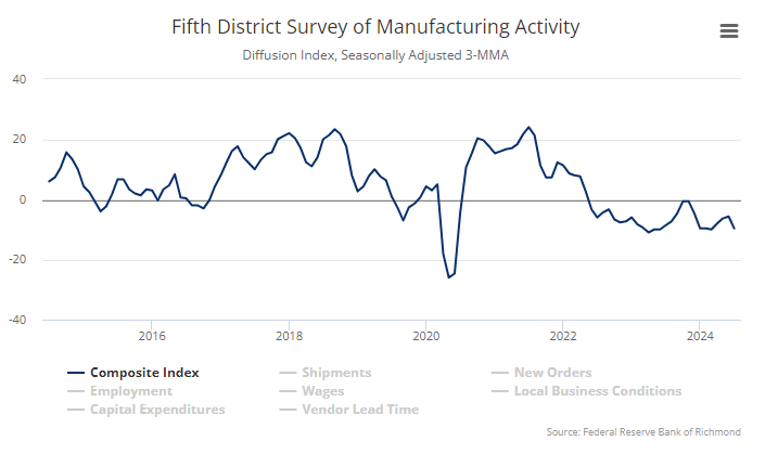
Richmond Fed manufacturing activity worsened in July 2024 with the composite manufacturing index decreasing from −10 in June to −17 in July. Of its three component indexes, shipments fell notably from −9 to −21, new orders decreased from −16 to −23, and employment edged down from −2 to −5. No matter how you cut it, manufacturing is not doing well in the U.S.
Existing-home sales faded 5.4% year-over-year in June 2024 . The median existing-home sales price grew 4.1% from June 2023 to $426,900. The inventory of unsold existing homes rose 3.1% from the previous month – the equivalent of 4.1 months’ supply at the current monthly sales pace. With the high mortgage rates, I see little ability of the lower segment of the middle class to buy a home.  NAR Chief Economist Lawrence Yun’s view:

We’re seeing a slow shift from a seller’s market to a buyer’s market. Homes are sitting on the market a bit longer, and sellers are receiving fewer offers. More buyers are insisting on home inspections and appraisals, and inventory is definitively rising on a national basis.

Here is a summary of headlines we are reading today:

Click on the “Read More” below to access these, other headlines, and the associated news summaries moving the markets today.

July 2024 Economic Forecast: One Recession Flag Removed But Little Indication The Economy Is Strengthening

Authored by Steven Hansen

EconCurrent‘s Economic Index marginally declined but remained slightly in positive territory. The economy remains very stratified where some sectors are going gangbusters, other sectors are barely above recessionary levels, whilst others are in recession territory. A major index is no longer indicating a recession is coming.  Read on to understand the currents affecting our economic growth.

Frank Li: The most efficient amateur male in pro/am ballroom dancing

Frank Li: The most efficient amateur male in pro/am ballroom dancing

My first out-of-town ballroom dance competition was OSB 2019, and I placed 4th (Gentlemen, Open Smooth, age-group C). After that, I started privately claiming that I am America’s most efficient male amateur in pro/am ballroom dancing (age-group C initially and S1 now) based on this simple fact: All the other five finalists had been dancing for many more years than I had. Now, it is time to reveal this claim publicly!

May 2024 Economic Forecast: No Real Change So Expect The Economy To Continue To Plod Along

Authored by Steven Hansen

EconCurrent‘s Economic Index was unchanged and remained slightly in positive territory. The economy remains very stratified where some sectors are going gangbusters whilst others are barely above recessionary levels. There remain three major indicators that suggest a recession is coming.  Read on to understand the currents affecting our economic growth.

Today Through the Fourth Friday (22 to 28 days) Weather Outlook for the U.S. and a Six-Day Forecast for the World: posted April 23, 2024

It is difficult to find a more comprehensive Weather Outlook anywhere else with the ability to get a local 10-day Forecast also.

This article focuses on what we are paying attention to in the next 48 to 72 hours. The article also includes weather maps for longer-term U.S. outlooks and a six-day World weather outlook which can be very useful for travelers.

First the NWS Short Range Forecast. The afternoon NWS text update can be found here but it is unlikely to have changed very much. The images in this article automatically update.

Short Range Forecast Discussion
NWS Weather Prediction Center College Park MD
Tue Apr 23 2024
Valid 12Z Tue Apr 23 2024 – 12Z Thu Apr 25 2024

…Unsettled weather and severe thunderstorm chances ramp up across parts
of the central and southern Plains this week…

…Above average temperatures throughout the western and central United
States, with cooler weather in the Great Lakes and much of the East…

The mostly quiet weather pattern experienced the last few days over the
Lower 48 is expected to gradually retreat as an upper trough develops over
the western U.S. midweek and sparks increasing thunderstorm chances
throughout the Great Plains and parts of the Midwest. First, a pair of
cold fronts crossing the Great Lakes and Ohio Valley today will spread
showers and isolated thunderstorms over the region before reaching the
Northeast on Wednesday. Temperatures may drop rapidly enough for
precipitation to end as snow across northern New England. Meanwhile, a
trailing cold front entering the southern Plains will be the focus for
thunderstorms over the next few days from northern and West Texas to
central Oklahoma. A few storms could be capable of producing large hail
and damaging wind gusts across northwest Texas today, which has prompted
the Storm Prediction Center to issue a Slight Risk (level 2/5) of severe
weather. A few isolated severe thunderstorms may also develop off a
southern High Plains dryline on Wednesday ahead of the approaching western
upper trough. This upper level system will aid in more widespread shower
and thunderstorm activity throughout the central and southern Plains on
Thursday. Scattered severe thunderstorms are possible as low pressure
develops over the central High Plains and a strengthening dryline pushes
eastward, with most of the severe potential located between south-central
Nebraska and northern Texas. Along with the severe thunderstorm threat,
heavy rain could lead to isolated instances of flash flooding.

Elsewhere, unsettled weather is also in the forecast throughout parts of
the Great Basin and eventually the Pacific Northwest by Thursday as
initial upper ridging and well above average temperatures gradually erode.
Much of the rainfall is expected to be mostly beneficial outside of any
lightning potential with thunderstorms over the central Great Basin. Highs
throughout the southwest are anticipated to reach the 80s and 90s through
Wednesday, with 60s and 70s for much of the Intermountain West.

Cooler weather is in store for the Great Lakes and much of the eastern
U.S. beginning with the potential for frost this morning from the southern
Appalachians to southern New England. Lows dipping into the 30s here may
damage sensitive plants and vegetation if left unprotected. Temperatures
are forecast to rebound this afternoon as highs reach into the 60s and 70s
ahead of the next spring cold front entering from the Great Lakes tonight.
This will allow for midweek temperatures to drop to around 10 to 20
degrees below average for the Great Lakes and Northeast, equating to high
temperatures ranging from the 40s in northern locations to 60s along the
northern Mid-Atlantic coastline.

To get your local forecast plus active alerts and warnings click HERE and enter your city, state or zip code.

Learn about wave patterns HERE.

Then, looking at the world and of course, the U.S. shows here also. Today we are looking at precipitation.

Please click on “Read More” below to access the full Daily Report issued today.