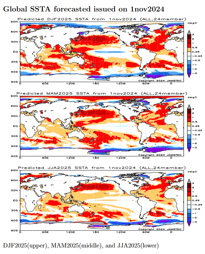
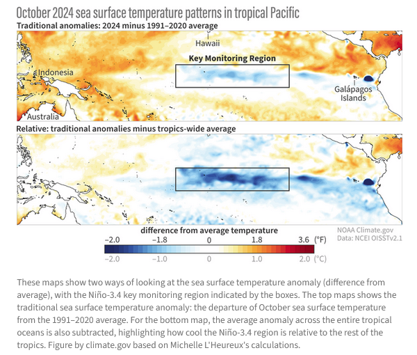
NOAA Updates its ENSO Alert on November 14, 2024 – We Remain in ENSO Neutral or do We?– Published November 15, 2024

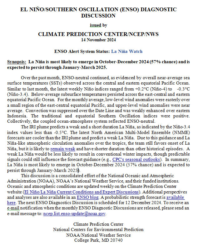
Synopsis:   In summary, La Niña is most likely to emerge in October-December 2024 (57% chance) and is expected to persist through January-March 2025).”

So we are really in ENSO Neutral but NOAA may not want to admit their forecast was wrong so they present it as waiting for La Nina. It is correct that we are in La Nina Watch but it is also correct that we currently remain in ENSO Neutral.

On the second Thursday of every month, NOAA (really their Climate Prediction Center CPC) issues its analysis of the status of ENSO. This includes determining the Alert System Status.  NOAA now describes their conclusion as “ENSO Alert System Status: La Nino Watch”

The exact timing of the transition is now perhaps more clear which should increase the reliability of the Seasonal Outlook to be issued next Thursday.

We have included an ENSO Blog article by Emily  Becker. It raises the question which I have raised before. With Global Warming, are we measuring the phases of ENSO correctly?

CLIMATE PREDICTION CENTER ENSO DISCUSSION (LINK)

The second paragraph is what is important:

The IRI plume predicts a weak and short duration La Niña, as indicated by the Niño-3.4 index values less than -0.5°C. The latest North American Multi-Model Ensemble (NMME) forecasts are cooler than the IRI plume and predict a weak La Niña.  Due to this guidance and La Niña-like atmospheric circulation anomalies over the tropics, the team still favors the onset of La Niña, but it is likely to remain weak and have a shorter duration than other historical episodes.  A weak La Niña would be less likely to result in conventional winter impacts, though predictable signals could still influence the forecast guidance (e.g., CPC’s seasonal outlooks).  In summary, La Niña is most likely to emerge in October-December 2024 (57% chance) and is expected to persist through January-March 2025).

Below is the middle paragraph from the discussion last month.

“The IRI plume predicts a weak and a short duration La Niña, as indicated by the Niño-3.4 index values less than -0.5°C. The latest North American Multi-Model Ensemble (NMME) forecasts were warmer this month, but still predict a weak La Niña.  As a result of the warmer predictions and the recent weakening of equatorial trade winds, the team still favors a weak event, but has lowered the chances of La Niña.  A weaker La Niña implies that it would be less likely to result in conventional winter impacts, though predictable signals could still influence the forecast guidance (e.g., CPC’s seasonal outlooks).  In summary, La Niña is favored to emerge in September-November (60% chance) and is expected to persist through January-March 2025).”

We now provide additional details.

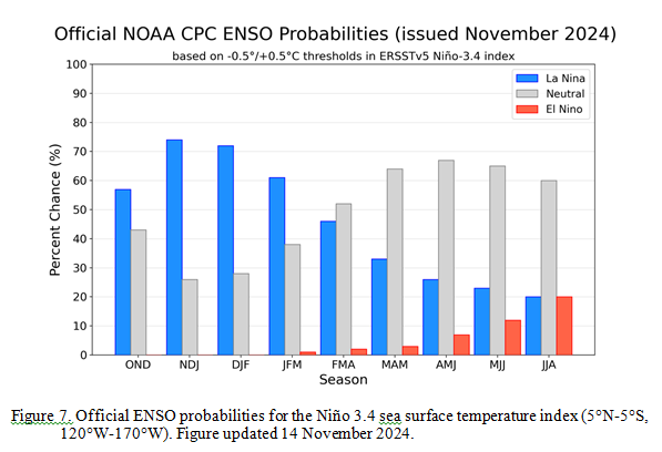
CPC Probability Distribution

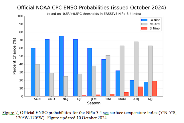
Here are the new forecast probabilities. The probabilities are for three-month periods e.g. ASO  stands for August/September/October.

Here is the forecast from last month.

The analysis this month and last month are a bit different with again the transition to La Nina being slightly slower than thought last month. Also, the probabilities of a La Nina are lower than estimated last month. This seems to be a trend. The chart is clearer than the discussion in the summary report above.  The La Nina is a bit slower to arrive. I am not sure that we will actually have a La Nina.  However, one should read the Emily Becker article, which is discussed later in this article.

Some will need to click on “Read More” to read the rest of this article.

Weather Outlook for the U.S. for Today Through at Least 22 Days and a Six-Day Forecast for the World: posted November 15, 2024

This article focuses on what we are paying attention to in the next 48 to 72 hours. The article also includes weather maps for longer-term U.S. outlooks (up to four weeks) and a six-day World weather outlook which can be very useful for travelers.

First the NWS Short Range Forecast. The afternoon NWS text update can be found here after about 4 p.m. New York time but it is unlikely to have changed very much from the morning update. The images in this article automatically update.

Short Range Forecast Discussion
NWS Weather Prediction Center College Park MD
Fri Nov 15 2024
Valid 12Z Fri Nov 15 2024 – 12Z Sun Nov 17 2024

…Unsettled weather persists throughout much of the West today before the
next strong storm system enters the Pacific Northwest on Saturday…

…Elevated fire weather concerns continue across parts of the Northeast…

…Next round of heavy rain and severe weather potential to develop over
the Southern Plains late Sunday…

The end of the workweek and upcoming weekend will have plenty of potential
weather hazards scattered across the Nation as we reach the midway point
of November. A system crossing the Intermountain West today will continue
to bring areas of moderate snowfall from the central Sierra Nevada to the
Northern Rockies into Saturday. The highest elevations have high chances
(>70%) for at least 4 inches of snowfall and coincide with where Winter
Weather Advisories have been issued. Precipitation is also possible across
the Northern Plains on Saturday as an area of low pressure crosses the
region, with a mix of rain and snow at times. This system will also have
the potential to produce periods of strong winds across parts of the
Montana Front Range on Saturday. As the weekend begins, a strong frontal
boundary and surge of Pacific moisture is set to move inland across the
Pacific Northwest and bring the potential for heavy coastal/lowland
rainfall and snow to the Washington and Oregon Cascades. In fact, Winter
Storm Watches have been hoisted for the Cascades due to the potential for
total snow accumulations of 1 to 2 feet, with locally higher snow amounts
over the highest peaks.

For the East, two separate storm systems brushing coastal regions while a
large area of high pressure builds into the Great Lakes and slides over
the Appalachians by Sunday will drive weather conditions through this
weekend. Gusty winds and locally heavy rain are possible along the Outer
Banks of North Carolina and surrounding Mid-Atlantic coastline today due
to a rapidly deepening, but quickly exiting, low pressure system. Showers
and strong winds will be short-lived as the storm races eastward into the
open Atlantic by tonight, with breezy conditions remaining due to a tight
pressure gradient related to high pressure over the Great Lakes. A
separate storm system swinging into the Canadian Maritimes will produce
showers over parts of Maine, with a light glaze of freezing rain possible
today where temperatures hang just below the freezing mark. In between
these two system will remain a very dry and breezy Northeast, prompting an
additional few days of fire weather concerns. Conditions will remain ripe
for developing wildfires through at least Saturday thanks to a stiff
northwest breeze and low relative humidity, including major I-95 cities
between Philadelphia and Boston.

By late this weekend the next rainmaker for the Southern Plains is
forecast to develop as an organizing low pressure system strengthens over
West Texas Sunday night. This system is then forecast to move
northeastward into Monday morning and spread numerous showers and
thunderstorms between the Texas Panhandle/North Texas to central Oklahoma.
Periods of heavy rain may lead to areas of flash flooding, especially in
urban and poor drainage locations. A few strong thunderstorms may also
have the potential to contain large hail, frequent lightning, and damaging
wind gusts.

To get your local forecast plus active alerts and warnings click HERE and enter your city, state or zip code.

Learn about wave patterns HERE.

Then, looking at the world and of course, the U.S. shows here also. Today we are looking at precipitation.

Please click on “Read More” below to access the full Daily Report issued today.

Weather Outlook for the U.S. for Today Through at Least 22 Days and a Six-Day Forecast for the World: posted November 14, 2024

This article focuses on what we are paying attention to in the next 48 to 72 hours. The article also includes weather maps for longer-term U.S. outlooks (up to four weeks) and a six-day World weather outlook which can be very useful for travelers.

First the NWS Short Range Forecast. The afternoon NWS text update can be found here after about 4 p.m. New York time but it is unlikely to have changed very much from the morning update. The images in this article automatically update.

Short Range Forecast Discussion
NWS Weather Prediction Center College Park MD
Thu Nov 14 2024
Valid 12Z Thu Nov 14 2024 – 12Z Sat Nov 16 2024

…A rapidly developing coastal storm is expected to bring a period of
gusty winds, enhanced rainfall and thunderstorms from the Carolinas to the
Mid-Atlantic states Thursday night into Friday…

…Lower elevation/coastal rain and mountain snow continue for the Pacific
Northwest Thursday; a rain/snow mix will spread inland across the Great
Basin and Rockies Thursday and Friday…

…Most of the country will see seasonable to above average temperatures
to end the week…

Showers will continue this morning and into Thursday afternoon ahead of a
low pressure/frontal system pushing through the Great Lakes region, with
precipitation chances gradually winding down with time and eastward extent
Thursday evening as the system weakens. To the south, more vigorous
showers and thunderstorms and heavier rainfall will continue ahead of the
front over the Upper Ohio/Tennessee Valleys and into the Southeast,
spreading into the central/southern Appalachians Thursday afternoon. Then,
by Thursday evening, a secondary low is expected to develop along the
coast of the Carolinas and deepen as it moves offshore, helping to enhance
onshore flow and rain chances over the Carolinas and southern Mid-Atlantic
into Thursday night. Some gusty winds will also be possible. Rain chances
should quickly taper off from west to east by Friday morning as the low
moves away from the coast. Further north, an area of low pressure lifting
northward over the Atlantic and into Nova Scotia will bring some showers
and possibly a wintry mix into Maine on Friday.

A Pacific frontal system moving through the West will spread precipitation
chances inland over the next couple of days. Lower elevation/coastal rain
and higher elevation snowfall over the Pacific Northwest and northern
California will continue through the day Thursday before tapering off into
Thursday evening as moist flow from the Pacific comes to an end. A lower
elevation rain/snow mix and higher elevation snow will spread further
inland with the system over the northern Rockies/Great Basin Thursday and
into the central Great Basin/Rockies on Friday. Some moderate to locally
heavy snowfall is also forecast for the Sierra Nevada through Friday.

Most of the country will see seasonable to above average temperatures
Thursday and Friday. Central portions of the country will continue to see
temperatures 5-15 degrees above average as an upper-level ridge passes
over the region. Forecast highs generally range from the 40s and 50s for
the Great Lakes/Midwest, the 50s for the northern Plains, the 60s for the
central Plains, and the 60s and 70s for the southern Plains. Highs will be
more seasonable and even a bit below average for the East Coast Thursday,
with 40s and 50s for New England, the Mid-Atlantic, and the Carolinas.
Temperatures will rebound a bit Friday as conditions moderate, with highs
5-10 degrees warmer and into the 50s and 60s. Areas of the Southeast/Gulf
Coast ahead of the cold front will see highs as warm as the upper 70s
Thursday before falling into the 60s and low 70s following the frontal
passage on Friday. Most of the inland West will see seasonable to above
average highs Thursday ahead of the incoming frontal system, with highs in
the 50s for the Great Basin/Rockies/Four Corners region and the 80s into
the Desert Southwest. Highs on Friday will drop into the 40s for the Great
Basin and 60s to low 70s for the Desert Southwest following the frontal
passage. The West Coast will see highs mainly in the 50s and 60s.

To get your local forecast plus active alerts and warnings click HERE and enter your city, state or zip code.

Learn about wave patterns HERE.

Then, looking at the world and of course, the U.S. shows here also. Today we are looking at precipitation.

Please click on “Read More” below to access the full Daily Report issued today.

Weather Outlook for the U.S. for Today Through at Least 22 Days and a Six-Day Forecast for the World: posted November 13, 2024

This article focuses on what we are paying attention to in the next 48 to 72 hours. The article also includes weather maps for longer-term U.S. outlooks (up to four weeks) and a six-day World weather outlook which can be very useful for travelers.

First the NWS Short Range Forecast. The afternoon NWS text update can be found here after about 4 p.m. New York time but it is unlikely to have changed very much from the morning update. The images in this article automatically update.

Short Range Forecast Discussion
NWS Weather Prediction Center College Park MD
Wed Nov 13 2024
Valid 12Z Wed Nov 13 2024 – 12Z Fri Nov 15 2024

…Atmospheric River brings heavy coastal rain and high-elevation mountain
snow to the Pacific Northwest and northern California Wednesday…

…Showers and thunderstorms will bring locally heavy rainfall to the
Lower Ohio, Tennessee, and Mississippi Valleys Wednesday, with the risk
for some scattered flash flooding in Louisiana and Mississippi…

…Above average temperatures continue for much of the central U.S. and
Gulf Coast states while colder air moves into the Northeast and the West…

Heavy lower elevation rain and high elevation mountain snow continues in
the Pacific Northwest this morning as a Pacific frontal system and
associated plume of moisture/Atmospheric River move inland over the
region. Precipitation coverage will expand southward into northern
California through the day Wednesday, with favorable upslope locations
along the coastal ranges and Cascades seeing locally heavy rainfall with
an isolated risk for flooding. Precipitation will also spread inland with
the front into the northern Rockies/Great Basin bringing rain and a wintry
mix to lower elevations and more snow to higher elevations in the local
mountain ranges. Precipiation chances across the region will continue into
Thursday, though with more moderate amounts expected as the moisture
flowing in from the Pacific wanes.

Gulf moisture flowing northward ahead of a low pressure/frontal system
over the Mississippi Valley will help trigger a broad area of showers and
thunderstorms today stretching from the Midwest/Great Lakes south through
the Ohio, Tennessee, and Lower Mississippi Valleys. Greater and deeper
moisture content closer to the Gulf as well as some marginal instability
will bring the threat for some locally heavy downpours producing a few
inches of rain for the Lower Ohio, Tennessee, and Lower Mississippi
Valleys, where a Marginal Risk of Excessive Rainfall (level 1/4) is in
effect for some isolated flash flooding. A targeted Slight Risk (level
2/4) has been introduced from central Louisiana northeast into central
Mississippi where higher confidence in greater rainfall rates and very wet
antecedent conditions from prior heavy rainfall events may lead to a few
more scattered instances of flash flooding. The system will continue
eastward on Thursday, bringing shower and thunderstorm chances to the
Upper Ohio Valley, Appalachians, and the Carolinas/Southeast, while
lingering across the Great Lakes. Some more moderate to locally heavy
rainfall totals are most likely across the central/southern Appalachians
and Carolinas where precipitation will be enhanced by a second frontal
boundary lifting northward from the Gulf. The rest of the country will
remain mostly dry.

Much of the central U.S. and Gulf Coast states continue to see above
average high temperatures by around 5-15 degrees this week. Forecast highs
Wednesday and Thursday range from the 40s and 50s in the Great
Lakes/Midwest; 50s in the northern Plains; 50s and 60s in the central
Plains, Middle Mississippi Valley, and Ohio Valley; the 70s for Texas and
the Lower Mississippi Valley, and the 80s along the Gulf Coast and into
Florida. Frontal passages and generally unsettled weather along the East
Coast and in the West will keep temperatures cooler and more seasonable in
these areas. Forecast highs range from the 30s and 40s in New England, the
40s and 50s in the Mid-Atlantic, and the 50s and 60s from the Carolinas
south into Georgia. In the West, highs Wednesday are in the 40s and 50s
for the Pacific Northwest and Interior West, the 60s in California, and
the 70s in the Desert Southwest. Temperatures will moderate for eastern
interior areas on Thursday as upper-level ridging builds northward, with
highs climbing into the 50s and 60s for the Rockies and Four Corners
Region, and the 80s for the Desert Southwest.

To get your local forecast plus active alerts and warnings click HERE and enter your city, state or zip code.

Learn about wave patterns HERE.

Then, looking at the world and of course, the U.S. shows here also. Today we are looking at precipitation.

Please click on “Read More” below to access the full Daily Report issued today.

Weather Outlook for the U.S. for Today Through at Least 22 Days and a Six-Day Forecast for the World: posted September 28, 2024

This article focuses on what we are paying attention to in the next 48 to 72 hours. The article also includes weather maps for longer-term U.S. outlooks (up to four weeks) and a six-day World weather outlook which can be very useful for travelers.

First the NWS Short Range Forecast. The afternoon NWS text update can be found here after about 4 p.m. New York time but it is unlikely to have changed very much from the morning update. The images in this article automatically update.

Short Range Forecast Discussion
NWS Weather Prediction Center College Park MD
Sat Sep 28 2024
Valid 12Z Sat Sep 28 2024 – 12Z Mon Sep 30 2024

…HELENE is forecast to continue to weaken and dissipate by Monday…

…There is a Marginal Risk of excessive rainfall over parts of the
Ohio/Tennessee Valleys on Saturday and over the Central
Appalachians/Mid-Atlantic Sunday…

…There are Excessive Heat Warnings over parts of Southeastern California
and the Southwest…

HELENE is forecast to continue to weaken and dissipate by Monday. The
system will produce moderate to heavy rain over parts of the
Ohio/Tennessee Valleys. Therefore, the WPC has issued a Marginal Risk
(level 1/4) of excessive rainfall over parts of the Ohio/Tennessee Valleys
through Sunday morning. The associated heavy rain will create localized
areas of flash flooding, affecting areas that experience rapid runoff with
heavy rain.

On Sunday, the area of moderate to heavy rain will move eastward to the
Central Appalachians/Mid-Atlantic. Therefore, the WPC has issued a
Marginal Risk (level 1/4) of excessive rainfall over parts of the Central
Appalachians/Mid-Atlantic from Sunday through Monday morning. The
associated heavy rain will create localized areas of flash flooding,
affecting areas that experience rapid runoff with heavy rain. In addition,
there will be a Marginal Risk of excessive rainfall over parts of the
Florida Peninsula on Saturday and Sunday.

Meanwhile, a wave of low pressure over the Pacific Northwest will move
northeastward into West-Central Canada by Sunday while the trailing front
moves into the Northern Plains. The system is expected to produce little
precipitation along the boundary.

Moreover, an upper-level high will remain over the Four Corners Region
through Monday. High temperatures over Southeastern California and the
Southwest will range from the upper 90s to 110s, and low temperatures will
be in the upper 80s to low 90s, providing little relief from the heat
overnight. The temperatures have prompted Excessive Heat Warnings over
parts of Southeastern California and the Southwest

To get your local forecast plus active alerts and warnings click HERE and enter your city, state or zip code.


Learn about wave patterns HERE.

Then, looking at the world and of course, the U.S. shows here also. Today we are looking at precipitation.

Please click on “Read More” below to access the full Daily Report issued today.

23 July 2024 Market Close & Major Financial Headlines: Markets Opened Fractionally Lower, Then Traded Back And Forth Across The Unchanged Line Finally Closing About Where They Opened

Summary Of the Markets Today:

  • The Dow closed down 57 points or 0.14%,
  • Nasdaq closed down 0.06%,
  • S&P 500 closed down 0.16%,
  • Gold $2,410 up $15.10,
  • WTI crude oil settled at $77 down $1.04,
  • 10-year U.S. Treasury 4.251 down 0.008 points,
  • USD index $104.47 up $0.15,
  • Bitcoin $65,662 down $1,896 or 2.81%,

*Stock data, cryptocurrency, and commodity prices at the market closing.


Click here to read our current Economic Forecast – July 2024 Economic Forecast: One Recession Flag Removed But Little Indication The Economy Is Strengthening


Today’s Economic Releases Compiled by Steven Hansen, Publisher:

Richmond Fed manufacturing activity worsened in July 2024 with the composite manufacturing index decreasing from −10 in June to −17 in July. Of its three component indexes, shipments fell notably from −9 to −21, new orders decreased from −16 to −23, and employment edged down from −2 to −5. No matter how you cut it, manufacturing is not doing well in the U.S.

Existing-home sales faded 5.4% year-over-year in June 2024 . The median existing-home sales price grew 4.1% from June 2023 to $426,900. The inventory of unsold existing homes rose 3.1% from the previous month – the equivalent of 4.1 months’ supply at the current monthly sales pace. With the high mortgage rates, I see little ability of the lower segment of the middle class to buy a home.  NAR Chief Economist Lawrence Yun’s view:

We’re seeing a slow shift from a seller’s market to a buyer’s market. Homes are sitting on the market a bit longer, and sellers are receiving fewer offers. More buyers are insisting on home inspections and appraisals, and inventory is definitively rising on a national basis.

Here is a summary of headlines we are reading today:

Click on the “Read More” below to access these, other headlines, and the associated news summaries moving the markets today.

July 2024 Economic Forecast: One Recession Flag Removed But Little Indication The Economy Is Strengthening

Authored by Steven Hansen

EconCurrent‘s Economic Index marginally declined but remained slightly in positive territory. The economy remains very stratified where some sectors are going gangbusters, other sectors are barely above recessionary levels, whilst others are in recession territory. A major index is no longer indicating a recession is coming.  Read on to understand the currents affecting our economic growth.

May 2024 Economic Forecast: No Real Change So Expect The Economy To Continue To Plod Along

Authored by Steven Hansen

EconCurrent‘s Economic Index was unchanged and remained slightly in positive territory. The economy remains very stratified where some sectors are going gangbusters whilst others are barely above recessionary levels. There remain three major indicators that suggest a recession is coming.  Read on to understand the currents affecting our economic growth.

Today Through the Fourth Friday (22 to 28 days) Weather Outlook for the U.S. and a Six-Day Forecast for the World: posted April 23, 2024

It is difficult to find a more comprehensive Weather Outlook anywhere else with the ability to get a local 10-day Forecast also.

This article focuses on what we are paying attention to in the next 48 to 72 hours. The article also includes weather maps for longer-term U.S. outlooks and a six-day World weather outlook which can be very useful for travelers.

First the NWS Short Range Forecast. The afternoon NWS text update can be found here but it is unlikely to have changed very much. The images in this article automatically update.

Short Range Forecast Discussion
NWS Weather Prediction Center College Park MD
Tue Apr 23 2024
Valid 12Z Tue Apr 23 2024 – 12Z Thu Apr 25 2024

…Unsettled weather and severe thunderstorm chances ramp up across parts
of the central and southern Plains this week…

…Above average temperatures throughout the western and central United
States, with cooler weather in the Great Lakes and much of the East…

The mostly quiet weather pattern experienced the last few days over the
Lower 48 is expected to gradually retreat as an upper trough develops over
the western U.S. midweek and sparks increasing thunderstorm chances
throughout the Great Plains and parts of the Midwest. First, a pair of
cold fronts crossing the Great Lakes and Ohio Valley today will spread
showers and isolated thunderstorms over the region before reaching the
Northeast on Wednesday. Temperatures may drop rapidly enough for
precipitation to end as snow across northern New England. Meanwhile, a
trailing cold front entering the southern Plains will be the focus for
thunderstorms over the next few days from northern and West Texas to
central Oklahoma. A few storms could be capable of producing large hail
and damaging wind gusts across northwest Texas today, which has prompted
the Storm Prediction Center to issue a Slight Risk (level 2/5) of severe
weather. A few isolated severe thunderstorms may also develop off a
southern High Plains dryline on Wednesday ahead of the approaching western
upper trough. This upper level system will aid in more widespread shower
and thunderstorm activity throughout the central and southern Plains on
Thursday. Scattered severe thunderstorms are possible as low pressure
develops over the central High Plains and a strengthening dryline pushes
eastward, with most of the severe potential located between south-central
Nebraska and northern Texas. Along with the severe thunderstorm threat,
heavy rain could lead to isolated instances of flash flooding.

Elsewhere, unsettled weather is also in the forecast throughout parts of
the Great Basin and eventually the Pacific Northwest by Thursday as
initial upper ridging and well above average temperatures gradually erode.
Much of the rainfall is expected to be mostly beneficial outside of any
lightning potential with thunderstorms over the central Great Basin. Highs
throughout the southwest are anticipated to reach the 80s and 90s through
Wednesday, with 60s and 70s for much of the Intermountain West.

Cooler weather is in store for the Great Lakes and much of the eastern
U.S. beginning with the potential for frost this morning from the southern
Appalachians to southern New England. Lows dipping into the 30s here may
damage sensitive plants and vegetation if left unprotected. Temperatures
are forecast to rebound this afternoon as highs reach into the 60s and 70s
ahead of the next spring cold front entering from the Great Lakes tonight.
This will allow for midweek temperatures to drop to around 10 to 20
degrees below average for the Great Lakes and Northeast, equating to high
temperatures ranging from the 40s in northern locations to 60s along the
northern Mid-Atlantic coastline.

To get your local forecast plus active alerts and warnings click HERE and enter your city, state or zip code.

Learn about wave patterns HERE.

Then, looking at the world and of course, the U.S. shows here also. Today we are looking at precipitation.

Please click on “Read More” below to access the full Daily Report issued today.

Nonfinancial Corporate Credit and Inflation: Part 3

The full data sets for the 71 years from 1952 to 2022 show no discernable association patterns (correlations) for nonfinancial credit growth and inflation changes.1  Thus, we started an analysis by looking specifically at the various regimes of inflation change during the 71-year timeline.  The most recent post2 analyzed the eight time periods over 71 years with positive inflation surges.  This article analyzes the five periods for 1952-2022 with negative inflation (disinflation/deflation) surges.


Photo by Dennis Siqueira on Unsplash.