Today Through the Fourth Friday (22 to 28 days) Weather Outlook for the U.S. and a Six-Day Forecast for the World: posted February 4, 2024

It is difficult to find a more comprehensive Weather Outlook anywhere else with the ability to get a local 10-day Forecast also.

This article focuses on what we are paying attention to in the next 48 to 72 hours. The article also includes weather maps for longer-term U.S. outlooks and a six-day World weather outlook which can be very useful for travelers.

First the highlights from the NWS.

Short Range Forecast Discussion
NWS Weather Prediction Center College Park MD
Sun Feb 04 2024
Valid 12Z Sun Feb 04 2024 – 12Z Tue Feb 06 2024

…Life threatening flooding likely across central/southern California
Sunday and Monday…

…Heavy Snow will cause extreme impacts over much of the Sierra Nevada on
Sunday and Monday…

…Showers and thunderstorms expected for portions of the Southeast and
Florida Sunday, with the chance for some severe weather in South Florida…

…Anomalous warmth continues across the Northern/Central Plains and
Upper/Middle Mississippi Valley…

Looking out a bit farther and focusing on the more series events:

Above is a 72 hour animation of the forecast.

Then, looking at the world and of course, the U.S. shows here also. Today we are looking at precipitation.

Please click on “Read More” below to access the full report issued today.

Hydroxyl radical: A critical air quality cleaning agent – February 3, 2024

I read a Climate.Gov blog post attributed to the Climate.Gov Staff. You can access it HERE.  I spent maybe four hours researching the topic separate from the time it takes to publish this article. I know some chemistry both from college and my work in the mining industry but this was intense. There is a paper written about this topic which you can pay to access HERE. I rarely write about things where the reader can not access the full article without paying for it but I am making an exception today for five reasons:

  • Climate.gov thought it was important to talk about this when they could not provide the underlying article to their readers.  However, I was able to access and include the Abstract in this article.
  • The hydroxyl radical plays a part in cleaning the atmosphere of pollutants including Greenhouse Gases.
  • If you search “Hydroxyl” you will find a lot of literature on this topic.
  • This dinosaur, your author, was intrigued with what is Hydroxyl and why the symbol was OH and not HO.
  • I am interested in Weather Modification to increase precipitation and I thought I needed to know about this.

Today Through the Fourth Friday (22 to 28 days) Weather Outlook for the U.S. and a Six-Day Forecast for the World: posted February 3, 2024

It is difficult to find a more comprehensive Weather Outlook anywhere else with the ability to get a local 10-day Forecast also.

This article focuses on what we are paying attention to in the next 48 to 72 hours. The article also includes weather maps for longer-term U.S. outlooks and a six-day World weather outlook which can be very useful for travelers.

First the highlights from the NWS.

Short Range Forecast Discussion
NWS Weather Prediction Center College Park MD
Sat Feb 03 2024
Valid 12Z Sat Feb 03 2024 – 12Z Mon Feb 05 2024

…Showers and thunderstorms Saturday for the Lower Mississippi Valley,
with the risk of scattered flash flooding along the Gulf Coast…

…Moderate to heavy snowfall Saturday for portions of the
Northern/Central Rockies and eastern Great Basin…

…Strong Atmospheric River to bring a considerable risk for flash
flooding and very heavy snow to California beginning Saturday night…

…Mild, well above average temperatures will persist across central
portions of the country this weekend…

Looking out a bit farther and focusing on the more series events:

Above is a 72 hour animation of the forecast.

Then, looking at the world and of course, the U.S. shows here also. Today we are looking at precipitation.

Please click on “Read More” below to access the full report issued today.

Today Through the Fourth Friday (22 to 28 days) Weather Outlook for the U.S. and a Six-Day Forecast for the World: posted February 2, 2024

It is difficult to find a more comprehensive Weather Outlook anywhere else with the ability to get a local 10-day Forecast also.

This article focuses on what we are paying attention to in the next 48 to 72 hours. The article also includes weather maps for longer-term U.S. outlooks and a six-day World weather outlook which can be very useful for travelers.

First the highlights from the NWS.

Short Range Forecast Discussion
NWS Weather Prediction Center College Park MD
Fri Feb 02 2024
Valid 12Z Fri Feb 02 2024 – 12Z Sun Feb 04 2024

…Unsettled weather for the West Friday as heavy snow continues for the
Sierra and spreads into the Great Basin and Rockies…

…Widespread thunderstorms shift from the Southern Plains Friday to the
Lower Mississippi Valley/Gulf Coast on Saturday, with a threat for severe
weather and flash flooding…

…Mild, well above average temperatures persist across central portions
of the country through this weekend…

Looking out a bit farther and focusing on the more series events:

Above is a 72 hour animation of the forecast.

Then, looking at the world and of course, the U.S. shows here also. Today we are looking at precipitation.

Please click on “Read More” below to access the full report issued today.

NOAA Updates its February 2024 Weather Outlook – Substantially Different from the Mid-Month Outlook – February 1, 2024

At the end of every month, NOAA updates its Outlook for the following month which in this case is February of 2024. We are reporting on that tonight.

There have been some significant changes in the Outlook for February and these are addressed in the NOAA Discussion so it is well worth reading.  We provided the prior Mid-Month Outlook for February  for comparison. It is easy to see the changes by comparing the Mid-Month and Updated Maps.

The article includes the Drought Outlook for February. NOAA also adjusted the previously issued Seasonal (FMA) Drought Outlook to reflect the changes in the February Drought Outlook. We have included a map showing the amount of water in the snowpack waiting to be released in the Spring. We also provide the Week 2/3 Tropical Outlook for the World.  We also include a very interesting CLIMAS Podcast.

The best way to understand the updated outlook for February is to view the maps and read the NOAA discussion. I have highlighted the key statements in the NOAA Discussion.

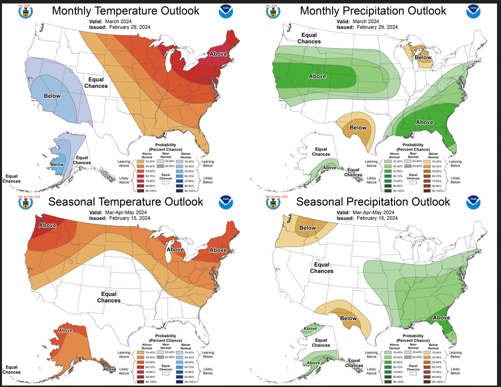
I am going to start with graphics that show the updated Outlook for December and the Mid-Month Outlook for February. This is followed by a graphic that shows both the Updated Outlook for February and the three-month outlook for FMA 2024. So you get the full picture in three graphics.

Here is the updated Outlook for February 2024.

For Comparison Purposes, Here is the earlier Mid-Month Outlook for February.


There have been some significant changes especially related to precipitation. Remember, it is the top set of maps that are the current outlook for February. When the Mid-month Outlook was issued we were not sure that it and the FMA map agreed with the discussion. It is a huge change. You can track the actual weather and updates of the outlook in our Daily Weather Article.

Combination of the Updated Outlook for February and the Three-Month Outlook

The top row is the Updated Outlook for the new month. There is a temperature map and a precipitation map. The second row is a three-month outlook that includes the new month. I think the outlook maps are self-explanatory. What is important to remember is that they show deviations from the current definition of normal which is the period 1991 through 2020.  So this is not a forecast of the absolute value of temperature or precipitation but the change from what is defined as normal or to use the technical term climatology.
The three-month map was issued on January 18, 2024.  One expects some changes  13 days later. But the change to the precipitation map is very dramatic. Thus to some extent, I question the reliability of the FMA three-month map.  As an example look at Arizona and New Mexico. Assuming February turns out as shown, imagine how dry March and April would have to be for the three-month map to be accurate. The same goes for the North Central Temperature Map. We have to take into consideration what wetter than normal means in different months.  For Arizona and New Mexico February tends to be dry so wetter than normal may not be much in terms of inches of precipitation.
Some readers may need to click “Read More” to read the rest of the article.  Some will feel that they have enough information. But there is a lot more information in the rest of this article.

Today Through the Fourth Friday (22 to 28 days) Weather Outlook for the U.S. and a Six-Day Forecast for the World: posted February 1, 2024

It is difficult to find a more comprehensive Weather Outlook anywhere else with the ability to get a local 10-day Forecast also.

This article focuses on what we are paying attention to in the next 48 to 72 hours. The article also includes weather maps for longer-term U.S. outlooks and a six-day World weather outlook which can be very useful for travelers.

First the highlights from the NWS.

Short Range Forecast Discussion
NWS Weather Prediction Center College Park MD
Thu Feb 01 2024
Valid 12Z Thu Feb 01 2024 – 12Z Sat Feb 03 2024

…Heavy snow over parts of the Sierra Nevada Mountains, light to moderate
snow over Lower Great Lakes/Northern New England, light snow over the
higher elevations of the West…

…There is a Slight Risk of excessive rainfall over parts of Southern
California on Thursday…

…Temperatures will be 15 to 25 degrees above average from the Plains to
the Upper/Middle Mississippi Valley…

Looking out a bit farther and focusing on the more series events:


Looking at the world and of course, the U.S. shows here also. This evening we are looking at precipitation and the baseline here is such that it will tend to show warmer than baseline-normal precipitation due to the trend in temperatures.

Please click on “Read More” below to access the full report issued today.

Short Term and Intermediate-Term Weather Outlooks for the U.S. and a Six-Day Forecast for the World: posted January 31, 2024

This article focuses on what we are paying attention to in the next 48 to 72 hours. The article also includes weather maps for longer-term U.S. outlooks and a six-day World weather outlook which can be very useful for travelers.

First the highlights from the NWS.

Short Range Forecast Discussion
NWS Weather Prediction Center College Park MD
Wed Jan 31 2024
Valid 12Z Wed Jan 31 2024 – 12Z Fri Feb 02 2024

…Heavy snow over parts of the Sierra Nevada Mountains, moderate snow
over Upstate New York/Northern New England, light snow over the higher
elevations of the West…

…There is a Slight Risk of excessive rainfall over parts of Northern/
Central California on Wednesday and Southern California on Thursday…

…Temperatures will be 15 to 30 degrees above average from the Plains to
the Upper/Middle Mississippi Valley…

Looking out a bit farther and focusing on the more series events:


Looking at the world and of course, the U.S. shows here also. This evening we are looking at precipitation and the baseline here is such that it will tend to show warmer than baseline-normal precipitation due to the trend in temperatures.

Please click on “Read More” below to access the full report issued today.

Short Term and Intermediate-Term Weather Outlooks for the U.S. and a Six-Day Forecast for the World: posted January 30, 2024

This article focuses on what we are paying attention to in the next 48 to 72 hours. The article also includes weather maps for longer-term U.S. outlooks and a six-day World weather outlook which can be very useful for travelers.

First the highlights from the NWS.

Short Range Forecast Discussion
NWS Weather Prediction Center College Park MD
Tue Jan 30 2024
Valid 12Z Tue Jan 30 2024 – 12Z Thu Feb 01 2024

…Heavy snow over parts of the Sierra Nevada Mountains on Wednesday…

…There is a Slight Risk of excessive rainfall over parts of Northern/
Central California…

…Snow over parts of the Great Lakes/Central Appalachians into the
Northeast…
 

Looking out a bit farther and focusing on the more series events:


Looking at the world and of course, the U.S. shows here also. This evening we are looking at precipitation and the baseline here is such that it will tend to show warmer than baseline-normal precipitation due to the trend in temperatures.

Please click on “Read More” below to access the full report issued today.

Short Term and Intermediate-Term Weather Outlooks for the U.S. and a Six-Day Forecast for the World: posted January 29, 2024

This article focuses on what we are paying attention to in the next 48 to 72 hours. The article also includes weather maps for longer-term U.S. outlooks and a six-day World weather outlook which can be very useful for travelers.

First the highlights from the NWS.

Short Range Forecast Discussion
NWS Weather Prediction Center College Park MD
Mon Jan 29 2024
Valid 12Z Mon Jan 29 2024 – 12Z Wed Jan 31 2024

…Light snow over parts of the Great Lakes and the Central Appalachians…

…Light rain over parts of the Pacific Northwest and Northern
California…

…Temperatures will be 10 to 20 degrees above average over parts of the
Northern/Central Plains into the Upper Midwest…

Looking out a bit farther and focusing on the more series events:


Looking at the world and of course, the U.S. shows here also. This evening we are looking at precipitation and the baseline here is such that it will tend to show warmer than baseline-normal precipitation due to the trend in temperatures.

Please click on “Read More” below to access the full report issued today.

Short Term and Intermediate-Term Weather Outlooks for the U.S. and a Six-Day Forecast for the World: posted January 28, 2024

This article focuses on what we are paying attention to in the next 48 to 72 hours. The article also includes weather maps for longer-term U.S. outlooks and a six-day World weather outlook which can be very useful for travelers.

First the highlights from the NWS.

Short Range Forecast Discussion
NWS Weather Prediction Center College Park MD
Sun Jan 28 2024
Valid 12Z Sun Jan 28 2024 – 12Z Tue Jan 30 2024

…Heavy snow over parts of the Northeast and snow over parts of the
Appalachians on Sunday…

…Scattered rain/freezing rain over parts of eastern New York State into
Southern New England…

…Temperatures will be 15 to 25 degrees above average over parts of
Northern/Central High Plains…

Looking out a bit farther and focusing on the more series events:


Looking at the world and of course, the U.S. shows here also. This evening we are looking at precipitation and the baseline here is such that it will tend to show warmer than baseline-normal precipitation due to the trend in temperatures.

Please click on “Read More” below to access the full report issued today.