Today Through the Fourth Friday (22 to 28 days) Weather Outlook for the U.S. and a Six-Day Forecast for the World: posted May 17, 2024

This article focuses on what we are paying attention to in the next 48 to 72 hours. The article also includes weather maps for longer-term U.S. outlooks and a six-day World weather outlook which can be very useful for travelers.

First the NWS Short Range Forecast. The afternoon NWS text update can be found here but it is unlikely to have changed very much. The images in this article automatically update.

Short Range Forecast Discussion
NWS Weather Prediction Center College Park MD
Fri May 17 2024
Valid 12Z Fri May 17 2024 – 12Z Sun May 19 2024

…Potentially significant heavy rainfall threat spreads into portions of
southern Mississippi and western Alabama Friday…

…Wet start to the weekend for much of the eastern U.S. as well as the
Northern Rockies/Plains…

…Sweltering heat continues across South Florida and southern Texas into
this weekend…

A broad area of showers and thunderstorms is expected Friday across much
of the eastern U.S., with the chance for moderate to heavy rainfall likely
to focus from the Lower Great Lakes south through the Appalachians into
the Ohio/Tennessee Valleys and to the Gulf Coast. Starting along the Gulf
Coast, another day of potentially significant flash flooding is forecast
along and to the south of a warm front lifting slowly northward across the
region. A Moderate Risk of Excessive Rainfall (level 3/4) has been issued
for portions of southern Mississippi and Alabama where a complex of
organized, heavy downpour-producing storms is forecast over already
saturated soils from storms Thursday night. The location of these
additional storms will likely be influenced by the storms ongoing
overnight, bringing higher uncertainty and highlighting the importance of
remaining aware of the most current forecast. To the north, an active
series of shortwaves will help encourage a couple additional areas of
locally heavier rainfall focused over portions of the central Appalachians
as well as the Lower Ohio/Middle Mississippi Valley. Slight Risks of
Excessive Rainfall (level 2/4) are in place for both locations for the
threat of some scattered instances of flash flooding. Storm chances will
shift southeastward on Saturday, bringing the focus for moderate to heavy
rainfall to the southern Mid-Atlantic south along the coastal Carolinas
into Georgia and lingering along the central Gulf Coast. A Slight Risk of
Excessive Rainfall has been included here for portions of the central Gulf
Coast where higher available moisture is most likely to lead to locally
heavier downpours on top of already saturated conditions from the previous
days’ rainfall. Additional scattered instances of flash flooding remain
possible.

Another frontal system will bring shower and storm chances to the Northern
Rockies/High Plains early Friday and the Northern Plains/Upper-Midwest by
Friday evening. Generally light to moderate rainfall is expected, with the
more moderate rain most likely near the Red River Valley. Cooler
conditions may lead to some snow mixing in through the Northern Rockies,
though no accumulations are expected. Precipitation chances will taper off
into Saturday as the bulk of the system lifts northeastward into Canada.
However, to the southwest, some showers and storms will be possible late
Saturday into early Sunday along a trailing frontal boundary stretching
into the Central Plains.

Conditions will continue to remain unseasonably hot and very much
Summer-like for portions of South Florida and southern Texas into the
weekend. Forecast highs Friday and Saturday range from the low to mid-90s
in South Florida and the mid 90s to mid-100s in southern Texas,
potentially record-tying/breaking temperatures. High humidity will bring
heat indices into the mid- to upper-100s for many locations.
Unfortunately, this pattern looks to continue not only into next week but
into the following week as well. While not quite as hot, temperatures will
also be well-above average and Summer-like across portions of the Northern
and Central Plains Friday, with highs in the mid- to upper 80s forecast.
These temperatures will shift eastward into the Great Lakes region on
Saturday. Variable highs are expected for the rest of the central/eastern
U.S., with above average conditions into the 70s for most of the Northeast
Friday and Saturday, though portions of the Mid-Atlantic will see a cool
down into the 60s Saturday. Slightly below average conditions following a
frontal passage over the Southern Plains and Southeast will continue
Friday with highs mainly in the 70s to low 80s, though a quick warm-up
into the mid-80s to 90s will come Saturday for the Southern Plains. In the
West, conditions will be below average in the Pacific Northwest and along
coastal California, with highs mainly in the 60s. However, above average
conditions are expected into the interior, with highs in the 70s to low
80s in the Great Basin, 80s for the central California valleys, and 90s to
low 100s for the Desert Southwest.

To get your local forecast plus active alerts and warnings click HERE and enter your city, state or zip code.

Learn about wave patterns HERE.

Then, looking at the world and of course, the U.S. shows here also. Today we are looking at precipitation.

Please click on “Read More” below to access the full Daily Report issued today.

Today Through the Fourth Friday (22 to 28 days) Weather Outlook for the U.S. and a Six-Day Forecast for the World: posted May 16, 2024

This article focuses on what we are paying attention to in the next 48 to 72 hours. The article also includes weather maps for longer-term U.S. outlooks and a six-day World weather outlook which can be very useful for travelers.

First the NWS Short Range Forecast. The afternoon NWS text update can be found here but it is unlikely to have changed very much. The images in this article automatically update.

Short Range Forecast Discussion
NWS Weather Prediction Center College Park MD
Thu May 16 2024
Valid 12Z Thu May 16 2024 – 12Z Sat May 18 2024

…Severe thunderstorms along with significant flash flooding possible
across portions of East Texas into the Gulf States through Saturday
morning…

…Unsettled weather persists across the Northeast and Central U.S today…

…Hazardous heat possible across South Florida and South Texas this week

Rain will spread across the Southern Plains and Gulf states as a hot,
moist airmass settles in across the South. This airmass will also
attribute to stint of unusually hot temperatures for South Florida and
Texas with heat indices rising above 100 degrees. Owing to the combination
of oppressive heat indices and forecast record warm overnight temperatures
in these areas, major heat-related impacts are possible with this round of
hot weather through the work week according to experimental NWS HeatRisk
guidance. The abundant moisture streaming northward as a warm front will
pool over Texas and the western/central Gulf Coast which will further
enhance rainfall efficiency and intensity as the cold front over the
Southern Plains advances eastward. Areal averages of 3 to 5 inches with
isolated higher amounts are expected to fall over areas that are already
sensitive from recent heavy rain and flooding. WPC has High Risk in effect
for portions of eastern Texas and western Louisiana today, which is a
level 4 out of 4 for significant impacts. There will likely be numerous
areas that will experience excessive rainfall and flooding. In additional
to the rainfall threat, there will also be strong to severe thunderstorms.
SPC has an Enhanced Risk in place for today with the primary threats are
large hail and damaging winds followed by a Slight Risk for Friday for the
central Gulf states. WPC had another Moderate Risk depicted over southern
Mississippi and Alabama, as the environment is ripe for continued
thunderstorm development on Friday.

Along the Eastern Seaboard, coastal low pressure located over the southern
DelMarVa will maintain locally heavy rainfall chances over Eastern Long
Island and Coastal New England through the morning hours, with 2-3″ of
rain and isolated flash flooding possible as the storm wraps up offshore.
Much of this activity in the Northeast will remain steady stratiform
rainfall, with the bulk of robust thunderstorms being confined to parts of
the Mid-Atlantic and Southeast. Across the West, most locations will have
dry and calm weather.

To get your local forecast plus active alerts and warnings click HERE and enter your city, state or zip code.

Learn about wave patterns HERE.

Then, looking at the world and of course, the U.S. shows here also. Today we are looking at precipitation.

Please click on “Read More” below to access the full Daily Report issued today.

Today Through the Fourth Friday (22 to 28 days) Weather Outlook for the U.S. and a Six-Day Forecast for the World: posted May 15, 2024

This article focuses on what we are paying attention to in the next 48 to 72 hours. The article also includes weather maps for longer-term U.S. outlooks and a six-day World weather outlook which can be very useful for travelers.

First the NWS Short Range Forecast. The afternoon NWS text update can be found here but it is unlikely to have changed very much. The images in this article automatically update.

Short Range Forecast Discussion
NWS Weather Prediction Center College Park MD
Wed May 15 2024
Valid 12Z Wed May 15 2024 – 12Z Fri May 17 2024

…Unsettled weather spreads into parts of the Midwest, Mid-Atlantic, and
Southeast today…

…Hazardous heat possible across South Florida and South Texas this week

…Significant flash flooding possible across portions of East Texas and
Louisiana on Thursday…

Showers and thunderstorms will continue to move through the eastern U.S.
ahead of an advancing low pressure system lifting through the Tennessee
Valley/Mid-Atlantic region and a slow moving cold front through the
Northeast. Showers and thunderstorms will also be ushered into the Plains
along and ahead of a cold front. Some of these storms may have the
potential to become severe and possibly produce areas of excessive
rainfall through Thursday morning. SPC has an Enhanced Risk for sever
weather for the Texas Panhandle and portions of Oklahoma and southern
Kansas with Slight Risks for the Carolinas and central Florida. Across
South Florida, persistent southwesterly winds ahead of an approaching
mid-level ridge axis will set the stage for very warm weather, with heat
indices exceeding 100 degrees possible. Localized Major heat-related
impacts are possible with this round of hot weather through the work week
according to experimental NWS HeatRisk guidance. Hazardous heat also will
build into South Texas today and Thursday as a warm front returns
northward from the Gulf of Mexico, ushering in a very warm and moist
airmass into the region.

With the return of the heat there will also be an environment that will be
very conducive for widespread heavy rainfall for the Gulf Coast, Southern
Plains and Lower/Mid-Mississippi Valley which could be a potentially
significant heavy rain event. SPC has a Slight Risk in place across the
South and WPC has a Moderate (Level 3 out of 4) for excessive rainfall for
eastern Texas and Louisiana. Areal averages of 2 to 4 inches is forecast
for the western Gulf states and locally higher amounts will be possible.
Over the past 2 weeks there has been a near continuous stream of heavy
rainfall which has made much of this part of the region sensitive to any
additional rain.

To get your local forecast plus active alerts and warnings click HERE and enter your city, state or zip code.

Learn about wave patterns HERE.

Then, looking at the world and of course, the U.S. shows here also. Today we are looking at precipitation.

Please click on “Read More” below to access the full Daily Report issued today.

Today Through the Fourth Friday (22 to 28 days) Weather Outlook for the U.S. and a Six-Day Forecast for the World: posted May 14, 2024

This article focuses on what we are paying attention to in the next 48 to 72 hours. The article also includes weather maps for longer-term U.S. outlooks and a six-day World weather outlook which can be very useful for travelers.

First the NWS Short Range Forecast. The afternoon NWS text update can be found here but it is unlikely to have changed very much. The images in this article automatically update.

Short Range Forecast Discussion
NWS Weather Prediction Center College Park MD
Tue May 14 2024
Valid 12Z Tue May 14 2024 – 12Z Thu May 16 2024

…Severe thunderstorms and flash flooding will impact portions of the
Gulf Coast and the Southeast on Tuesday…

…Above-average temperatures expected for South Florida and the West…

Wet and unsettled weather is in store for the Gulf Coast and Southeast
today thanks to a slow-moving frontal boundary. Showers and thunderstorms
across this region have the potential to turn severe and will be capable
of producing heavy rain. SPC has a Slight Risk for severe weather,
indicating the potential exists for multiple corridors of damaging winds,
very large hail, and a one or two tornadoes covering central/northern
Florida and southern Georgia. Additionally, WPC has a Slight Risk for
excessive rainfall and local flash flooding highlighted for much of the
same area as the severe weather threat while a broader Marginal Risk spans
northward to the Ohio Valley and Mid-Atlantic regions. As the system
advances eastward the threats for severe storms and heavy rainfall will
reduce for Wednesday to a Marginal Risk.

Showers and storms over the lower Missouri an Mid-Mississippi valleys to
the Ohio Valley will spread east through the Mid-Atlantic and the
Northeast today. A brief window of drier weather over the Mississippi
Valley into early Wednesday will be followed by the next round of showers
and storms that will begin to spread into the region by late Wednesday.
Before impacting the central U.S. on Wednesday, this previously noted
system will spread showers and storms followed by much cooler temperatures
from the Northern Rockies into Central Rockies and High Plains on Tuesday.

South Florida will continue to have well above-normal, with near to record
high temperatures through Wednesday. Meanwhile, warmer temperatures will
spread across the western states reaching well-above normal highs across
the region by midweek.

To get your local forecast plus active alerts and warnings click HERE and enter your city, state or zip code.

Learn about wave patterns HERE.

Then, looking at the world and of course, the U.S. shows here also. Today we are looking at precipitation.

Please click on “Read More” below to access the full Daily Report issued today.

Today Through the Fourth Friday (22 to 28 days) Weather Outlook for the U.S. and a Six-Day Forecast for the World: posted May 13, 2024

This article focuses on what we are paying attention to in the next 48 to 72 hours. The article also includes weather maps for longer-term U.S. outlooks and a six-day World weather outlook which can be very useful for travelers.

First the NWS Short Range Forecast. The afternoon NWS text update can be found here but it is unlikely to have changed very much. The images in this article automatically update.

Short Range Forecast Discussion
NWS Weather Prediction Center College Park MD
Mon May 13 2024
Valid 12Z Mon May 13 2024 – 12Z Wed May 15 2024

…Severe thunderstorms and flash flooding will impact portions of the
Gulf Coast today and the Southeast Tuesday…

…Above average temperatures expected for the West…

A strong upper low will push east across the central U.S. today
accompanied by a strengthening surface low pressure system that will sweep
across the southern tier. A warm front will lift north across the Gulf
Coast ahead of the system and prime the environment for showers and
thunderstorms today. Severe thunderstorms are expected from central and
east Texas across portions of the Gulf Coast states to the Florida
Panhandle, and the Storm Prediction Center Convective Outlook highlights
this area with a Slight Risk (level 2/5) of Severe Thunderstorms with an
embedded Enhanced Risk (level 3/5) area. Potential storm hazards will
include significant wind gusts, very large hail, and a few tornadoes.
Additionally, anomalous moisture and high instability over the Gulf Coast
region will support waves of very heavy rainfall that will likely lead to
scattered to numerous instances of flash flooding. There is Slight Risk
(level 2/4) of Excessive Rainfall in effect from east Texas across
southern portions of the Gulf Coast states to the Florida Panhandle and a
Moderate Risk (level 3/4) in effect from the toe of the Louisiana boot to
the western Florida Panhandle. Heavy rainfall will also be possible
further north in parts of the Mid-Mississippi Valley and Upper Midwest
along a slow moving frontal boundary draped over the top of the southern
low pressure system.

The low pressure system will continue to move east through mid-week, and
the warm front will lift north across the Southeast while the trailing
cold front moves across the Lower Mississippi Valley on Tuesday.
Widespread showers and thunderstorms are forecast to develop across the
eastern U.S. on Tuesday, and although the severe thunderstorm threat will
be lower than it was on Monday, isolated severe storms with heavy rainfall
will be possible in the Southeast. By Tuesday night, showers and storms
will expand into the northeast as well, then the southern low pressure
system will push into the Atlantic on Wednesday.

Unsettled weather is also expected to develop in the Intermountain West
and the northern and central Plains as a frontal system moves south across
the region over the next few days. Low pressure will consolidate and
strengthen over the northern/central Plains on Tuesday and move towards
the Mississippi Valley on Wednesday, and this system will create chances
for showers and thunderstorms and high elevation snow.

Temperature-wise, highs will be generally above average for much of the
western third of the U.S. through mid-week, but cooler air will move into
the northern and central Rockies Tuesday into Wednesday in the wake of a
frontal system. Above average temperatures are also forecast for the
northern Plains, Great Lakes, and Ohio Valley today, but temperatures will
return to near average or dip slightly below average Tuesday and
Wednesday. Temperatures will be slightly below to near average for the
rest of the central and eastern U.S. with the exception of parts of
southern Texas and central and south Florida where temperatures will
remain above average. High temperatures in these areas will be in the 90s
and lower 100s, and some daily high temperature records may be tied or
broken.

To get your local forecast plus active alerts and warnings click HERE and enter your city, state or zip code.

Learn about wave patterns HERE.

Then, looking at the world and of course, the U.S. shows here also. Today we are looking at precipitation.

Please click on “Read More” below to access the full Daily Report issued today.

Today Through the Fourth Friday (22 to 28 days) Weather Outlook for the U.S. and a Six-Day Forecast for the World: posted May 12, 2024

This article focuses on what we are paying attention to in the next 48 to 72 hours. The article also includes weather maps for longer-term U.S. outlooks and a six-day World weather outlook which can be very useful for travelers.

First the NWS Short Range Forecast. The afternoon NWS text update can be found here but it is unlikely to have changed very much. The images in this article automatically update.

Short Range Forecast Discussion
NWS Weather Prediction Center College Park MD
Sun May 12 2024
Valid 12Z Sun May 12 2024 – 12Z Tue May 14 2024

…Heavy rain and severe thunderstorm chances extend from the southern
Plains to the lower Mississippi Valley and Southeast over the next few
days…

…Well above average temperatures expected throughout the West and
north-central United States…

Active weather is in the forecast for the southern U.S. over the next few
days as a low pressure system sweeps across the South into the Southeast.
A potent upper low will move over the Plains today, and low pressure will
deepen in the lee of the Rockies. The stalled frontal boundary across West
Texas and New Mexico will lift northeast as a warm front, and warm, moist
Gulf air will surge into the central/southern Plains and lower Mississippi
Valley. Widespread showers and thunderstorms are expected, and conditions
will be favorable for scattered strong to severe storms from eastern Texas
through central Louisiana. The Storm Prediction Center has issued a Slight
Risk of Severe Thunderstorms (level 2/5) for this area. Potential storm
hazards include large hail, damaging winds, and a couple tornadoes. In
addition to severe storm hazards, heavy rain falling on top of saturated
soils will likely lead to flash flooding. There is a Slight Risk of
Excessive Rainfall (level 2/4) in effect from eastern Texas into the lower
Mississippi Valley with an embedded Moderate Risk (level 3/4) area for
particularly sensitive areas in east Texas and western Louisiana. The low
pressure system will push eastwards this week, and the threat of severe
thunderstorms and heavy rainfall/flash flooding will shift across the
northern Gulf Coast to the Southeast.

To the north, a front moving south across the Upper Midwest and Great
Lakes region will produce showers and thunderstorms today and Monday, and
precipitation will push into the Northeast Tuesday. Precipitation chances
will also expand across the Mid-Atlantic on Tuesday ahead of the southern
low pressure system. In the northern Rockies and northern Plains, a
separate frontal system will be moving south across the region Monday into
Tuesday, and low elevation showers and storms and high elevation snow are
expected. Elsewhere, mostly dry weather is expected through Tuesday for
the West Coast and Southwest.

Summer-like temperatures will continue today across much of the West and
north-central U.S. with well-above average highs in the 70s and 80s, and
potentially the lower 90s for some. Below average temperatures are
forecast today for the rest of the central U.S. and much of the East
Coast. Temperatures will remain above average in the West through Tuesday,
but will begin to return to near normal Monday and Tuesday for the central
and eastern United States.

To get your local forecast plus active alerts and warnings click HERE and enter your city, state or zip code.

Learn about wave patterns HERE.

Then, looking at the world and of course, the U.S. shows here also. Today we are looking at precipitation.

Please click on “Read More” below to access the full Daily Report issued today.

Heat Stress Impact on Coral Reefs in the Florida Keys and The Future of Restoration – Posted on May 11, 2024

I do not think we have talked about Ocean Heat Stress before but it is important.

I swapped out the map in this article with another map from a prior article by this author.

 I have not had to give readers a warning before but some of the photography might be upsetting. It should be upsetting. The major problem with Global Warming and in this case, the warming of oceans is that Darwin works at one speed and our current rate of Warming exceeds the speed of adaptation.  But in the article, a way to assist the survival of the fittest is discussed.

Some Readers may have to click on “Read More” to access the rest of this action-packed article and access the two YouTubes.

Today Through the Fourth Friday (22 to 28 days) Weather Outlook for the U.S. and a Six-Day Forecast for the World: posted May 11, 2024

This article focuses on what we are paying attention to in the next 48 to 72 hours. The article also includes weather maps for longer-term U.S. outlooks and a six-day World weather outlook which can be very useful for travelers.

First the NWS Short Range Forecast. The afternoon NWS text update can be found here but it is unlikely to have changed very much. The images in this article automatically update.

Short Range Forecast Discussion
NWS Weather Prediction Center College Park MD
Sat May 11 2024
Valid 12Z Sat May 11 2024 - 12Z Mon May 13 2024

...Wet weekend in store for the Central/Southern Plains and adjacent
Rockies...

...Heavy rainfall and flash flooding possible for parts of the South and
Southeast Sunday through Tuesday...

...Above average temperatures forecast for the West and north-central U.S.
this weekend...

Precipitation chances will continue today for portions of the
central/southern Plains and adjacent Rockies, and coverage is expected to
increase with widespread showers and thunderstorms forecast to impact the
Plains today. Locally heavy rainfall and isolated severe thunderstorms
will be possible east of a stalled frontal boundary draped up against the
Rockies. Potential storm hazards will include hail, strong wind gusts, and
isolated flash flooding. In the higher elevations west of the frontal
boundary, wintry precipitation is expected, and some of the higher peaks
in Colorado and northern New Mexico could receive a few additional inches
of snow.

The surface front is expected to remain in place through tonight, then the
front will begin to lift north as a warm front across Texas and the Lower
Mississippi Valley on Sunday while low pressure deepens over the Plains.
Another round of widespread showers and thunderstorms will develop on
Sunday, and the threat of heavy rainfall will increase as warm Gulf air
moves into the region. There is a Slight Risk of Excessive Rainfall (level
2/4) from central Texas east to the Mississippi River. Scattered instances
of flash flooding will be possible, especially where soils are still moist
after recent heavy rains. The developing low pressure system is forecast
to push east across the Lower Mississippi Valley towards the Southeast on
Monday and Tuesday, and the heavy rainfall/flash flood threat will shift
east across the northern Gulf Coast states.

To the east, precipitation chances will return to the Mid-Atlantic and
Great Lakes regions today as an occluded frontal system pushes towards the
East Coast. Showers and thunderstorms will linger into Sunday morning
before the system moves offshore Sunday afternoon. Another frontal system
will drop south into the north-central U.S. over the weekend, which may
renew precipitation chances near the western Great Lakes on Sunday. Other
areas of the country should remain mostly dry through Monday.

Upper-level ridging over the West Coast and north-central U.S. will lead
to well-above average temperatures in these regions through the weekend.
High temperatures this afternoon will range from the 80s to lower 90s in
California and the Pacific Northwest and from the 70s to lower 80s in the
northern Plains. The focus for warmer temperatures will shift more into
the Interior West/Great Basin and Upper Midwest on Sunday. Below average
temperatures are forecast elsewhere across the eastern and central U.S.
through the weekend, but temperature will trend back towards normal early
in the work week.

To get your local forecast plus active alerts and warnings click HERE and enter your city, state or zip code.

Learn about wave patterns HERE.

Then, looking at the world and of course, the U.S. shows here also. Today we are looking at precipitation.

Please click on “Read More” below to access the full Daily Report issued today.

NOAA Updates its ENSO Alert on May 9, 2024 – The El Nino Advisory/La Nina Watch Continues. – La Nina Onset a Bit Slower than Prior Estimate – Published May 10, 2024

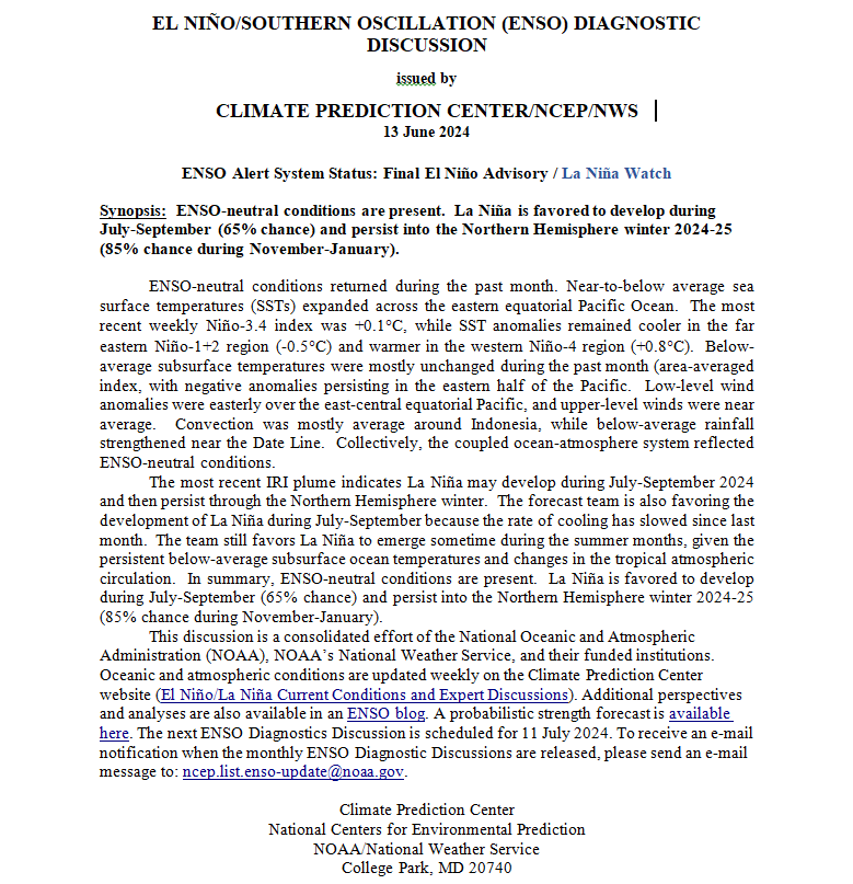
On the second Thursday of every month, NOAA (really their Climate Prediction Center CPC) issues its analysis of the status of ENSO. This includes determining the Alert System Status.  NOAA again describes their conclusion as “ENSO Alert System Status: El Nino Advisory La Nino Watch”

The exact timing of the transition is not very clear which will impact the reliability of the Seasonal Outlook to be issued next Thursday. It does look like the onset may be slightly slower than thought last month. This may turn out to be a trend i.e. recognizing that the onset will be less rapid than previously thought. I am just guessing. It is difficult to predict how the phases of ENSO will unfold.

We have included an ENSO Blog article by Emily Becker.

>

CLIMATE PREDICTION CENTER ENSO DISCUSSION


The second paragraph is what is important:

“The most recent IRI plume favors an imminent transition to ENSO-neutral, with La Niña developing during July-September 2024 and then persisting through the Northern Hemisphere winter. The forecast team continues to favor the dynamical model guidance, which suggests La Niña could form as early as June-August 2024, with higher confidence of La Niña during the following seasons. La Niña generally tends to follow strong El Niño events, which also provides added confidence in the model guidance favoring La Niña. In summary, a transition from El Niño to ENSO-neutral is likely in the next month. La Niña may develop in June-August (49% chance) or July-September (69% chance).”

Below is the middle paragraph from the discussion last month.

“The most recent IRI plume indicates a transition to ENSO-neutral during spring 2024, with La Niña potentially developing during late summer 2024.  The forecast team continues to favor the dynamical model guidance, which is slightly more accurate than statistical models during this time of year.  La Niña tends to follow strong El Niño events, which also provides added confidence in the model guidance favoring La Niña.  In summary, a transition from El Niño to ENSO-neutral is likely by April-June 2024 (85% chance), with the odds of La Niña developing by June-August 2024 (60% chance).”

We now provide additional details.

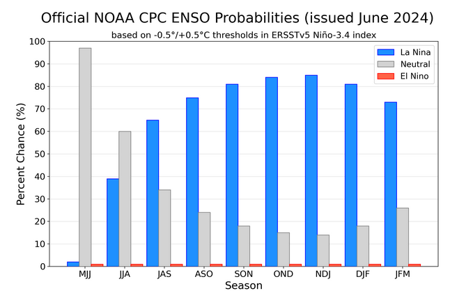
CPC Probability Distribution

Here are the new forecast probabilities. The probabilities are for three-month periods e.g. MAM stands for March/April/May.

Here is the current release of the probabilities:

This chart shows the forecasted progression of the evolution of ENSO from the current El Nino State to Neutral and by the summer to La Nina.  This kind of bar chart is not very good at showing uncertainty.

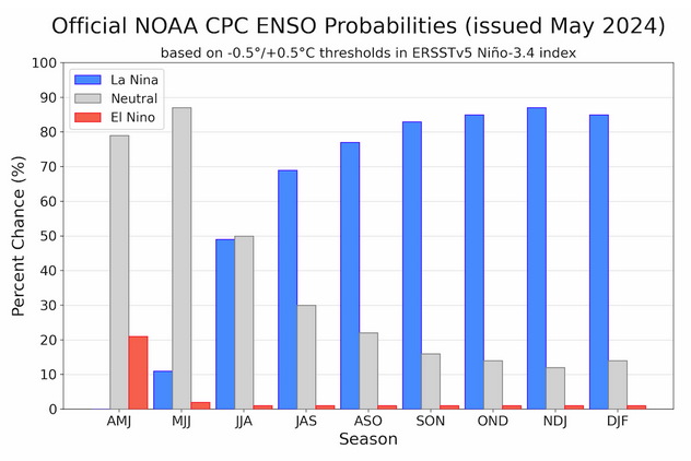
Here is the forecast from last month.

The analysis this month and last month are not very different.
Click on “Read More” to read the rest of this article.

Today Through the Fourth Friday (22 to 28 days) Weather Outlook for the U.S. and a Six-Day Forecast for the World: posted May 10, 2024

This article focuses on what we are paying attention to in the next 48 to 72 hours. The article also includes weather maps for longer-term U.S. outlooks and a six-day World weather outlook which can be very useful for travelers.

First the NWS Short Range Forecast. The afternoon NWS text update can be found here but it is unlikely to have changed very much. The images in this article automatically update.

Short Range Forecast Discussion
NWS Weather Prediction Center College Park MD
Fri May 10 2024
Valid 12Z Fri May 10 2024 – 12Z Sun May 12 2024

…Severe thunderstorms possible in the Mid-Atlantic and Southeast today…

…Above average temperatures will spread across the West and
north-central U.S. this weekend…

Showers and thunderstorms are forecast to continue today across the
Mid-Atlantic and the Southeast as a slow-moving cold front gradually
pushes towards the East Coast. Severe thunderstorms will be possible from
the eastern Carolinas where the Storm Prediction Center has highlighted an
area with a Slight Risk of Severe Thunderstorms (level 2/5) and in
southern Georgia and north Florida where there is another Slight Risk
(level 2/5) area with an embedded Enhanced Risk (level 3/5) area. The main
thunderstorm threat will be damaging winds, but hail and locally heavy
rainfall/isolated instances of flash flooding will be possible.
Precipitation will come to an end for most areas in these regions tonight
as the front moves into the Atlantic, but isolated showers and storms will
remain possible in south Florida through the weekend as the frontal
boundary slows/stalls.

By this afternoon, a frontal system will develop over the Upper Midwest
then push across the Great Lakes and Ohio Valley tonight. This system will
cause precipitation chances to return to the Mid-Atlantic and southern New
England on Saturday with another round of showers and thunderstorms
expected. This system is forecast to be weaker than the system that
impacted the region on Thursday and Friday, and severe thunderstorms are
not expected. Another front will drop south into the northern Plains and
upper Midwest on Sunday, but the frontal passage is expected to be mostly
dry with only some scattered showers and storms.

Meanwhile, an upper level low and a stationary surface front will be
positioned over the southwestern U.S., which will support low elevation
showers and thunderstorms over the central and southern High Plains and
the Four Corners region and high elevation wintry precipitation through
Saturday. Most lower elevation areas will see light to moderate rainfall,
though some heavier showers/storms will be possible heading into Saturday
evening for portions of west Texas, with some isolated flash flooding
possible. The upper low will gradually push east Saturday night into
Sunday, and precipitation chances will expand into the central and
southern Plains as a low pressure system develops. This system will push
east early next week, and warm, moist inflow from the Gulf of Mexico will
likely support heavy rainfall in the warm sector that could potentially
lead to flash flooding in parts of the South.

The Pacific Northwest and much of California will remain dry through this
weekend as surface high pressure and upper level ridging remain anchored
over the region. This will result in above average temperatures with highs
in the 80s and even lower 90s (15-25 degrees above average) in some areas.
The upper level ridge and above average temperatures will expand east
across the north-central U.S. over the weekend where highs will range from
the mid-70s to the lower 80s. Elsewhere, forecast precipitation and cloud
cover will result in temperatures below or near average.

To get your local forecast plus active alerts and warnings click HERE and enter your city, state or zip code.

Learn about wave patterns HERE.

Then, looking at the world and of course, the U.S. shows here also. Today we are looking at precipitation.

Please click on “Read More” below to access the full Daily Report issued today.