Looking Back at July 2024 for the U.S.. and the World – Published August 17, 2024

Much of the information in this report comes from the monthly emails I receive from John Bateman. He does public outreach for NOAA and in particular NCEI. I could find the same information and more on the NCEI website but John Bateman produces a good summary so I use it or most of it. I also add additional information from NCEI or other NOAA websites. At the end of the article, I provide links that will get you to the full reports and much additional information.

I do not yet have John Bateman’s report for July so I extracted the information directly from the NOAA sources.

 My comments if any are in boxes like this one.

I start with the trends of July, 2024 Temperature looking at North America and then the World both land and water. There is a graphic for just CONUS but the format is different and it is not as easy to read.

This is the temperature trend for North America. It covers a larger geographical area than just CONUS but I find it easier to read. It almost looks like the temperature has plateaued.

The temperature for the world, land and ocean hit a new record.

The temperature for the world, (land only) hit a new record. Notice that land temperatures increase faster than land and ocean as water takes more energy.

To read the rest of this article some will have to click on “Read More”.

Today Through the Fourth Friday (22 to 28 days) Weather Outlook for the U.S. and a Six-Day Forecast for the World: posted August 17, 2024

This article focuses on what we are paying attention to in the next 48 to 72 hours. The article also includes weather maps for longer-term U.S. outlooks and a six-day World weather outlook which can be very useful for travelers.

First the NWS Short Range Forecast. The afternoon NWS text update can be found here after about 4 p.m. New York time but it is unlikely to have changed very much from the morning update. The images in this article automatically update.

Short Range Forecast Discussion
NWS Weather Prediction Center College Park MD
Sat Aug 17 2024
Valid 12Z Sat Aug 17 2024 – 12Z Mon Aug 19 2024

…There is a Slight Risk of excessive rainfall over parts of the
Mid-Atlantic on Saturday/Sunday and Southwest/Eastern Great Basin on
Saturday…

…There is a Slight Risk of severe thunderstorms over parts of the
Pacific Northwest, Great Basin, and Ohio Valley on Saturday and southern
Mid-Atlantic to Southeast/Lower Mississippi Valley on Sunday…

…There are Excessive Heat Warnings and Heat Advisories over parts of the
Southern Plains and Lower Mississippi Valley…

A front extending from the Great Lakes/Ohio Valley across the Middle
Mississippi Valley and then to the Central High Plains will move eastward
to the Mid-Atlantic/Southeast Coast and southward to the Southern Plains
by Monday. On Saturday, showers and thunderstorms will develop along and
ahead of the boundary from the Great Lakes/Ohio Valley to the
Tennessee/Lower Mississippi Valleys.

Additionally, upper-level energy will intersect a pool of tropical
moisture over the northern Mid-Atlantic, producing heavy rain. Therefore,
the WPC has issued a Slight Risk (level 2/4) of excessive rainfall over
parts of the northern Mid-Atlantic through Sunday morning. The associated
heavy rain will create mainly localized areas of flash flooding, with
urban areas, roads, small streams, and low-lying areas the most
vulnerable.

Furthermore, the boundary will trigger showers and severe thunderstorms
over parts of southwestern Ohio, eastern Kentucky, and extreme
north-central Tennessee. Therefore, the SPC has issued a Slight Risk
(level 2/5) of severe thunderstorms over parts of the Ohio/Tennessee
Valleys through Sunday morning. The hazards associated with these
thunderstorms are frequent lightning, severe thunderstorm wind gusts,
hail, and a few tornadoes.

Moreover, upper-level energy and a plume of monsoonal moisture will aid in
creating showers and thunderstorms with heavy rain over parts of southern
Utah and northwestern Arizona. Therefore, the WPC has issued a Slight Risk
(level 2/4) of excessive rainfall over parts of the Great Basin/Southwest
through Sunday morning. The associated heavy rain will create mainly
localized areas of flash flooding, with urban areas, roads, small streams,
and low-lying areas the most vulnerable.

In addition, the energy will produce showers and severe thunderstorms over
parts of the Great Basin. Therefore, the SPC has issued a Slight Risk
(level 2/5) of severe thunderstorms over parts of the Great Basin through
Sunday morning. The hazards associated with these thunderstorms are
frequent lightning, severe thunderstorm wind gusts, and a minimal threat
of hail and tornadoes.

Also, an upper-level low over the Pacific Northwest Coast and associated
energy will develop showers and severe thunderstorms over parts of Oregon
and Washington State on Saturday. Therefore, the SPC has issued a Slight
Risk (level 2/5) of severe thunderstorms over parts of the Pacific
Northwest through Sunday morning. The hazards associated with these
thunderstorms are frequent lightning, severe thunderstorm wind gusts,
hail, and a minimal threat of tornadoes.

On Sunday, as the front moves into the Mid-Atlantic, Southeast, and Lower
Mississippi Valley, showers and severe thunderstorms will develop along
and ahead of the boundary. Therefore, the SPC has issued a Slight Risk
(level 2/5) of severe thunderstorms over parts of the southern
Mid-Atlantic to Southeast/Lower Mississippi Valley from Sunday through
Monday morning. The hazards associated with these thunderstorms are
frequent lightning, severe thunderstorm wind gusts, hail, and a minimal
threat of tornadoes.

Further, a strong pool of moisture will be over the Mid-Atlantic on
Sunday, aiding in producing showers and thunderstorms with heavy rain over
parts of the northern Mid-Atlantic. Therefore, the WPC has issued a Slight
Risk (level 2/4) of excessive rainfall over parts of the northern
Mid-Atlantic from Sunday through Monday morning. The associated heavy
rain will create mainly localized areas of flash flooding, with urban
areas, roads, small streams, and low-lying areas the most vulnerable.

Moreover, monsoonal moisture and daytime heating will create showers and
thunderstorms over parts of the Southwest, Eastern Great Basin, and
Central Rockies from late afternoon into late evening on Sunday.
Additionally, the upper-level low over the Northwest will produce rain,
with maybe an embedded thunderstorm over the region on Sunday.

Meanwhile, upper-level ridging over parts of the Southern Plains and
Lower Mississippi Valley will produce high temperatures in the upper-90s
to low-100s with dew points in the low to mid-70s have prompted Excessive
Heat Warnings and Heat Advisories over parts of the Southern Plains and
Lower Mississippi Valley. The sweltering summer heat will continue over
the south. A prolonged stretch of high temperatures in the upper 90s and
triple digits will be focused over portions of the Southern Plains and
Gulf Coast through Monday. Low temperatures in the low-80s/upper-70s are
also forecast along the Gulf Coast, providing little relief from the heat
overnight. Moreover, the combination of summer heat and high humidity will
support daily maximum heat indices near 110F. People spending more time or
effort outdoors or in a building without cooling are at an increased risk
of heat-related illness.

To get your local forecast plus active alerts and warnings click HERE and enter your city, state or zip code.

Learn about wave patterns HERE.

Then, looking at the world and of course, the U.S. shows here also. Today we are looking at precipitation.

Please click on “Read More” below to access the full Daily Report issued today.

NOAA Updates its Seasonal Outlook on August 15, 2024 – Similar to the Outlook Issued last Month but Shifted Out a Month or Two – Posted on August 16, 2024

On the third Thursday of the month right on schedule NOAA issued their updated Seasonal Outlook which I describe as their Four-Season Outlook because it extends a bit more than one year into the future. The information released also included the Mid-Month Outlook for the following month plus the weather and drought outlook for the next three months.  I present the information issued by NOAA and try to add context to it. It is quite a challenge for NOAA to address the subsequent month, the subsequent three-month period as well as the twelve successive three-month periods for a year or a bit more.

With respect to the long-term part of the Outlook which I call the Four-Season Outlook, the timing of the transition from Neutral to LaNina is challenging to predict.  We are now in ENSO Neutral. La Nina is the likely scenario soon through winter and into Spring next year.

From the NOAA discussion:

“The major climate driver during the winter and early spring 2024-2025 is expected to be La Niña and the outlooks from DJF 2024-2025 through FMA 2025 reflect this with above-normal temperatures favored for the Southern Great Plains, Lower Mississippi Valley, and Southeast.”

“Later in the fall and into the 2024-2025 winter, the three-month precipitation outlooks are based largely on La Niña composites. The spatial coverage for below-normal precipitation probabilities exceeding 50 percent is largest during DJF and JFM across southeastern New Mexico, Texas, and parts of the Southeast where the dry signal is the strongest and occurs most frequently according to La Niña composites. Based on the same reasoning, above-normal precipitation probabilities are at their largest during DJF for the Pacific Northwest. Typically during La Niña, a tight gradient of dry to wet from the Gulf Coast to the Tennessee and Ohio Valleys becomes established during the winter and early spring.”

I personally would not have total confidence in this outlook given the uncertainty about there actually being a La Nina and its strength if it does happen.  I  do not have the JAMSTEC outlook yet but for sure they will lean towards a weak La Nina with Modoki characteristics. I do not have a lot of confidence that NOAA knows how to deal with a La Nina Modoki. But they may have it exactly correct.

Let’s Take a Look at the (mid-month) Outlook for September

It will be updated on the last day of August.

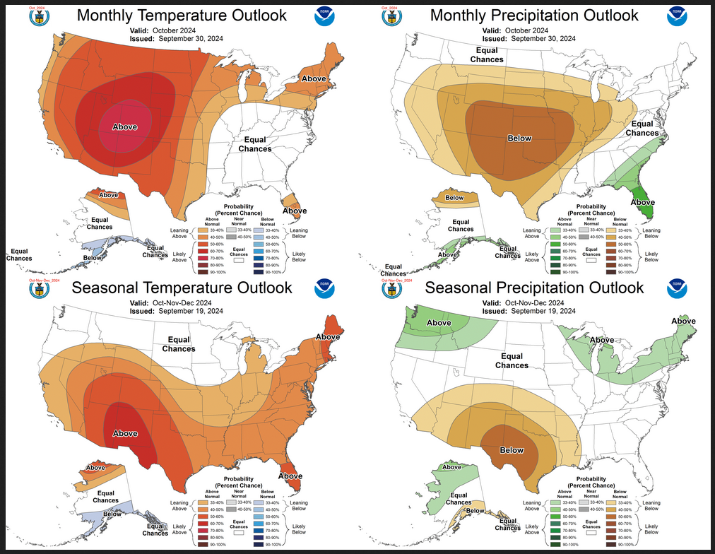
Then we look at a graphic that shows both the next month and the next three months.

The top row is what is now called the Mid-Month Outlook for next month which will be updated at the end of this month. There is a temperature map and a precipitation map. The second row is a three-month outlook that includes next month.  I think the outlook maps are self-explanatory. What is important to remember is that they show deviations from the current definition of normal which is the period 1991 through 2020.  So this is not a forecast of the absolute value of temperature or precipitation but the change from what is defined as normal or to use the technical term “climatology”.

Notice that the Outlook for next month and the three-month Outlook are fairly similar. This tells us that October and November will be fairly similar to September.

The full NOAA Seasonal Outlook extends through September/October/November of 2025 (yes that is more than a year out). All of these maps are in the body of the article. Large maps are provided for September and the three-month period September/October/November.  Small maps are provided beyond that through September/October/November of 2025 with a link to get larger versions of these maps.

NOAA provides a discussion to support the maps. It is included in the body of this article. In some cases, one will need to click on “read more” to read the full article. For those on my email list where I have sent the url of the article, that will not be necessary.

Today Through the Fourth Friday (22 to 28 days) Weather Outlook for the U.S. and a Six-Day Forecast for the World: posted August 16, 2024

This article focuses on what we are paying attention to in the next 48 to 72 hours. The article also includes weather maps for longer-term U.S. outlooks and a six-day World weather outlook which can be very useful for travelers.

First the NWS Short Range Forecast. The afternoon NWS text update can be found here after about 4 p.m. New York time but it is unlikely to have changed very much from the morning update. The images in this article automatically update.

Short Range Forecast Discussion
NWS Weather Prediction Center College Park MD
Fri Aug 16 2024
Valid 12Z Fri Aug 16 2024 – 12Z Sun Aug 18 2024

…There is a Slight Risk of excessive rainfall over parts of the
Tennessee Valley and Southern Appalachians on Friday…

…There is a Slight Risk of severe thunderstorms over parts of the
Central/Southern Plains on Friday…

…There are Excessive Heat Warnings and Heat Advisories over parts of the
Central/Southern Plains and Lower Mississippi/Tennessee Valleys…

A front extending from the Upper Great Lakes/Upper Mississippi Valley
across the Middle Mississippi Valley and then to the Central High Plains
will move eastward to the Lower Great Lakes/Mid-Atlantic, then westward to
the Southern Plains by Sunday. Showers and thunderstorms will develop
along and ahead of the boundary from the Great Lakes/Ohio Valley to the
Tennessee/Lower Mississippi Valleys into the Central/Southern Plains.

Additionally, the front will intersect a pool of tropical moisture over
the Tennessee Valley, producing heavy rain. Therefore, the WPC has issued
a Slight Risk (level 2/4) of excessive rainfall over parts of the
Tennessee Valley/Southern Appalachians through Saturday morning. The
associated heavy rain will create mainly localized areas of flash
flooding, with urban areas, roads, small streams, and low-lying areas the
most vulnerable.

Furthermore, upper-level energy moving over the Central Plains will
trigger showers and severe thunderstorms. Therefore, the SPC has issued a
Slight Risk (level 2/5) of severe thunderstorms over parts of the
Central/Southern Plains and adjacent areas through Saturday morning. The
hazards associated with these thunderstorms are frequent lightning, severe
thunderstorm wind gusts, hail, and a minimal threat of tornadoes.

On Saturday, as the front moves eastward, showers and thunderstorms will
develop over parts of the Lower Great Lakes/Eastern Ohio Valley, Central
Appalachians, Tennessee Valley, and Middle/Lower Mississippi Valley.

Elsewhere, monsoonal moisture and diurnal heating will produce showers and
thunderstorms over parts of the Southwest, Eastern Great Basin, and
Southern Rockies from late afternoon into late evening on Friday and
Saturday.

Moreover, upper-level energy and moisture moving over parts of the Pacific
Northwest will create rain with embedded thunderstorms over parts of the
Northwest on Saturday.

Meanwhile, upper-level ridging over parts of the Southern Plains and Lower
Mississippi Valley with high temperatures in the upper-90s to low-100s
with dew points in the low to mid-70s have prompted Excessive Heat
Warnings and Heat Advisories over parts of the Central/Southern Plains and
Lower Mississippi/Tennessee Valleys. The sweltering summer heat will
continue over the south. A prolonged stretch of high temperatures in the
upper 90s and triple digits will be focused over portions of the Southern
Plains and Gulf Coast through Sunday. Low temperatures around 80 degrees
are also forecast along the Gulf Coast. Moreover, the combination of
summer heat and high humidity will support daily maximum heat indices near
110F. People spending greater time or effort outdoors or in a building
without cooling is at an increased risk of heat-related illness.

To get your local forecast plus active alerts and warnings click HERE and enter your city, state or zip code.

Learn about wave patterns HERE.

Then, looking at the world and of course, the U.S. shows here also. Today we are looking at precipitation.

Please click on “Read More” below to access the full Daily Report issued today.

Today Through the Fourth Friday (22 to 28 days) Weather Outlook for the U.S. and a Six-Day Forecast for the World: posted August 15, 2024

This article focuses on what we are paying attention to in the next 48 to 72 hours. The article also includes weather maps for longer-term U.S. outlooks and a six-day World weather outlook which can be very useful for travelers.

First the NWS Short Range Forecast. The afternoon NWS text update can be found here after about 4 p.m. New York time but it is unlikely to have changed very much from the morning update. The images in this article automatically update.

Short Range Forecast Discussion
NWS Weather Prediction Center College Park MD
Thu Aug 15 2024
Valid 12Z Thu Aug 15 2024 – 12Z Sat Aug 17 2024

…Flash flooding and severe weather threat continues over the Midwest the
next couple of days…

…Potentially dangerous heat anticipated across the southern Plains,
lower Mississippi Valley, and Gulf Coast…

A low pressure/frontal system traversing the center of the country
continues to help trigger rounds of showers and thunderstorms leading to
the threat of some flash flooding and severe weather. The low pressure
center is forecast to gradually push eastward through the Upper Midwest
today and reach the Great Lakes by the end of the week. A broad warm
sector supported by plentiful moisture, instability, and deep-layer shear
will allow for storms to potentially turn severe and contain heavy
rainfall throughout Missouri, Illinois, and into the lower Ohio Valley.
Storms should redevelop during the afternoon, increasing in coverage into
the evening, with a Slight Risk (level 2/4) of Excessive Rainfall in
effect given the threat for some intense downpours and potential training
convection leading to instances of flash flooding. A Slight Risk (level
2/5) of severe weather similarly covers the chance for some instances of
large hail and damaging winds. The system will push into the Lower Great
Lakes and Ohio/Tennessee Valleys by Friday and Saturday, with storms
likely to spread as far east as the Appalachians and Mid-Atlantic. Some
chances of isolated flash flooding and severe weather are forecast.

Heat will remain the major weather story throughout much of the
south-central U.S. into the beginning of this weekend and likely beyond.
Widespread highs into the upper 90s and triple digits are forecast to span
from the Southwest to the central Gulf Coast. Elevated humidity levels
will soar heat indices up to around 110 degrees for areas outside of the
Southwest and southern High Plains. However, actual high temperatures in
these more arid regions will be higher and well into the triple digits for
some locations. Low temperatures are anticipated to only drop into the
upper 70s and 80s for many locations, which could break several daily
records. This level of heat can affect anyone without effective cooling
and/or adequate hydration. Therefore, it is imperative to follow proper
heat safety and check on vulnerable individuals.

Elsewhere, some showers and storms will continue over New England as an
upper-level low churns over Nova Scotia. To the south, portions of
central/south Florida will also see scattered storm chances the next
couple of days as a cold front slowly pushes through. Some thunderstorms
will also be possible with a shortwave passing over portions of the
northern Great Basin today and into the northern Rockies by tonight.
Monsoonal moisture and storm chances are set to return to the Southwest
and central Great Basin by Saturday, where isolated flash flooding is the
greatest concern. Forecast high temperatures are expected to generally be
around average along the East Coast with mid- to upper 80s expected. Areas
of the Great Lakes/Upper Midwest behind the passing storm system will be
cooler with highs in the 70s. More temperatures near or above average are
expected over the northern/central Plains with highs in the 80s and 90s.
Highs across the northern tier of the West will remain below average, with
70s for the Pacific Northwest and low 80s into the northern Great Basin,
warming closer to average into the central Great Basin with mid-80s to low
90s.

To get your local forecast plus active alerts and warnings click HERE and enter your city, state or zip code.

Learn about wave patterns HERE.

Then, looking at the world and of course, the U.S. shows here also. Today we are looking at precipitation.

Please click on “Read More” below to access the full Daily Report issued today.

Today Through the Fourth Friday (22 to 28 days) Weather Outlook for the U.S. and a Six-Day Forecast for the World: posted August 14, 2024

This article focuses on what we are paying attention to in the next 48 to 72 hours. The article also includes weather maps for longer-term U.S. outlooks and a six-day World weather outlook which can be very useful for travelers.

First the NWS Short Range Forecast. The afternoon NWS text update can be found here after about 4 p.m. New York time but it is unlikely to have changed very much from the morning update. The images in this article automatically update.

Short Range Forecast Discussion
NWS Weather Prediction Center College Park MD
Wed Aug 14 2024
Valid 12Z Wed Aug 14 2024 – 12Z Fri Aug 16 2024

…Flash flooding and severe weather threat forecast to stretch from the
central/northern Plains to the Midwest over the next few days…

…Potentially dangerous heat anticipated across the southern Plains,
lower Mississippi Valley, and Gulf Coast…

A developing storm system progressing from the central U.S. to the Great
Lakes by the end of the week is expected to spark numerous showers and
thunderstorms that could produce areas of hazardous weather conditions. As
the area of low pressure begins to organize and consolidate over the
northern Plains today, slow-moving thunderstorms may form across parts of
central North Dakota while also containing intense rainfall rates.
Additionally, a gradually lifting warm front extending from the central
Plains to the Ozarks may produce another focus for heavy rainfall through
tonight before the flash flooding threat centers over the mid-Mississippi
and lower Ohio valleys on Thursday. Scattered flash flooding will be
possible where the heaviest rainfall occurs, with urban areas and poor
drainage locations most at risk. Severe weather will also remain possible
today and extend into Thursday as developing thunderstorms grow upscale
and potentially contain damaging wind gusts and large hail. The most
likely regions at risk for severe weather include the mid-Missouri Valley
region today and much of Missouri and Illinois on Thursday. A couple of
tornadoes can’t be ruled out as well.

Elsewhere, an upper-level low displaced to the east of New England will
aid in scattered thunderstorm activity throughout the region over the next
couple of days. Further south, a cold front progressing over the Florida
Peninsula and lingering near the central Gulf Coast will also produce
areas of scattered summer convection. Be sure to remain weather aware if
spending time outdoors and seek shelter should storms begin to produce
lightning.

Heat will remain and major weather story throughout much of the
south-central U.S. through the end of this week and likely beyond.
Widespread highs into the upper 90s and triple digits are forecast to span
from the Southwest to the central Gulf Coast. Elevated humidity levels
will soar heat indices up to around 110 degrees in the southern Plains,
lower Mississippi Valley, and central Gulf Coast. Low temperatures are
anticipated to only drop into the upper 70s and 80s for many locations,
which could break several daily records. This level of heat can affect
anyone without effective cooling and/or adequate hydration. Therefore, it
is imperative to follow proper heat safety and check on vulnerable
individuals.

To get your local forecast plus active alerts and warnings click HERE and enter your city, state or zip code.

Learn about wave patterns HERE.

Then, looking at the world and of course, the U.S. shows here also. Today we are looking at precipitation.

Please click on “Read More” below to access the full Daily Report issued today.

Today Through the Fourth Friday (22 to 28 days) Weather Outlook for the U.S. and a Six-Day Forecast for the World: posted August 13, 2024

This article focuses on what we are paying attention to in the next 48 to 72 hours. The article also includes weather maps for longer-term U.S. outlooks and a six-day World weather outlook which can be very useful for travelers.

First the NWS Short Range Forecast. The afternoon NWS text update can be found here after about 4 p.m. New York time but it is unlikely to have changed very much from the morning update. The images in this article automatically update.

Short Range Forecast Discussion
NWS Weather Prediction Center College Park MD
Tue Aug 13 2024
Valid 12Z Tue Aug 13 2024 – 12Z Thu Aug 15 2024

…Heavy rain and flash flooding threat forecast to stretch from the
central Plains to the Midwest over the next few days…

…Potentially dangerous heat anticipated across the southern Plains,
lower Mississippi Valley, and Gulf Coast…

…Fire weather concerns and poor air quality continues for portions of
the Pacific Northwest, Northern Rockies, and Great Basin…

A mid-August weather pattern continues to take shape this week with
numerous areas of scattered thunderstorms impacting the Nation. A
stationary front currently stretching from the Southeast to the central
High Plains will be the focus for much of this activity, with the boundary
eventually forecast to lift north into the Midwest by Wednesday night due
to a deepening low pressure system in the central Plains. The most likely
weather hazard over the next few days with developing thunderstorms is
expected to be associated with heavy rainfall creating instances of flash
flooding, as well as the potential for isolated areas of damaging wind
gusts. Specifically, three separate areas along the front stand out today
as having the greatest chances for scattered flash floods. Parts of South
Carolina remain sensitive to locally heavy rain as the area continues to
contain saturated ground conditions, leading to a continued threat for
flash flooding as long as the atmosphere supports slow-moving
thunderstorms. For much of eastern Kansas and Missouri, an initial complex
of thunderstorms is forecast to move through the region this morning
containing locally heavy rainfall, while a reforming area of convection
overnight into Wednesday could create additional flooding concerns. This
second round of heavy rain has the potential to produce a narrow corridor
of impressive rainfall totals within a few hours near south-central
Missouri. Additionally, northeast Colorado can expect another round of
storms containing intense rainfall rates this evening as activity forms
along the leeward side of the Rockies and pushes eastward. Residents and
visitors are advised to have multiple ways of receiving warnings, have a
plan should flash flooding occur, and never drive through flooded
roadways. By midweek much of the heavy rain and thunderstorm activity is
anticipated to gradually shift eastward to the Midwest and lower Ohio
Valley, along with the strengthening low pressure system and lifting warm
front. Once again heavy rain will be a concern as ample atmospheric
moisture content creates ripe conditions for scattered vigorous downpours.

Dangerous summer heat will be confined to the southern U.S. this week as
highs into the upper 90s and triple digits span from the Southwest to the
Gulf Coast. The most anomalous and potentially dangerous heat is forecast
across the southern Plains and Gulf Coast States through the end of the
week as highs reach up to 10 degrees above the climatological average for
mid-August. Elevated humidity levels will lead to maximum heat indices up
to 110 degrees during the day and low temperatures only dipping into the
upper 70s and low 80s at night. People spending greater time or effort
outdoors, or in a building without effective cooling, are at an increased
risk of heat-related illnesses.

A persistent pattern supporting fire weather concerns across much of the
central and northern Great Basin is forecast to continue today with dry
terrain and periods of gusty winds. Red Flag Warnings remain in place from
eastern Oregon to Idaho. Ongoing wildfires also continue to spread smoke
into the atmosphere, leading to poor air quality.

To get your local forecast plus active alerts and warnings click HERE and enter your city, state or zip code.

Learn about wave patterns HERE.

Then, looking at the world and of course, the U.S. shows here also. Today we are looking at precipitation.

Please click on “Read More” below to access the full Daily Report issued today.

Today Through the Fourth Friday (22 to 28 days) Weather Outlook for the U.S. and a Six-Day Forecast for the World: posted August 12, 2024

This article focuses on what we are paying attention to in the next 48 to 72 hours. The article also includes weather maps for longer-term U.S. outlooks and a six-day World weather outlook which can be very useful for travelers.

First the NWS Short Range Forecast. The afternoon NWS text update can be found here after about 4 p.m. New York time but it is unlikely to have changed very much from the morning update. The images in this article automatically update.

Short Range Forecast Discussion
NWS Weather Prediction Center College Park MD
Mon Aug 12 2024
Valid 12Z Mon Aug 12 2024 – 12Z Wed Aug 14 2024

…Unsettled weather with chances for scattered flash flooding and
damaging wind gusts stretches from the Intermountain West to the
Mid-Mississippi Valley…

…Dangerous heat builds across the Southern Plains and Gulf Coast this
week…

…Critical Fire Weather and poor air quality remains throughout parts of
the Great Basin and Northwest…

An active August weather pattern is expected to continue through at least
midweek thanks in part to a stationary boundary stretching from the
Southeast to the central Plains and an upper-level trough moving from the
West Coast to the northern Rockies. Organized complexes of showers and
thunderstorms are forecast to ride along and just north of the stationary
front today from eastern Colorado to the Ozarks, with the main weather
hazard associated with intense rainfall rates and scattered flash
flooding. The heavy rainfall threat is then forecast to slide eastward
each day this week, centered over the Mid-Mississippi Valley on Tuesday
and Midwest by Wednesday. These areas coincide with a Slight Risk (level
2/4) of Excessive Rainfall. Additionally, some of the stronger storms will
have the potential to produce isolated hail and the potential for
localized damaging wind gusts. Thunderstorms will also develop throughout
parts of the Southwest, Intermountain West, and Rockies through Tuesday,
producing an isolated flash flood threat for these regions as well.

For the Southeast, the lingering frontal boundary will produce another few
days with scattered thunderstorm chances overlapping with saturated ground
conditions, particularly over the eastern Carolinas. Urban corridors and
locations with poor drainage (even more degraded than usual due to recent
heavy rain and flooding associated with T.S. Debby) will be most at risk.
Residents and visitors are advised to have multiple ways of receiving
warnings and never drive into flooded roadways.

While most of the country enjoys a break from the oppressive summer heat,
much of the southern Plains and Gulf Coast States will experience a
warming trend back to uncomfortable conditions this week. Widespread highs
into the upper 90s are forecast to stretch from the southern High Plains
to the Florida Panhandle, with triple digits possible over portions of the
Lone Star State. When combined with elevated humidity levels, heat indices
may reach up to around the 110 degree mark. Overnight temperatures will
not offer much relief as lows only dip into the upper 70s and low 80s.
This level of heat affects anyone without effective cooling and/or
adequate hydration as denoted by Major to Extreme HeatRisk stretching from
Oklahoma and Texas to the Gulf Coast and much of Florida by Wednesday.

Gusty winds combined with dry terrain are forecast to create Critical Fire
Weather across parts of northwest Nevada today. Meanwhile, ongoing
wildfires will also continue to pump additional smoke into the atmosphere
and produce poor air quality for much of the region.

cone graphic

To get your local forecast plus active alerts and warnings click HERE and enter your city, state or zip code.

Learn about wave patterns HERE.

Then, looking at the world and of course, the U.S. shows here also. Today we are looking at precipitation.

Please click on “Read More” below to access the full Daily Report issued today.

Today Through the Fourth Friday (22 to 28 days) Weather Outlook for the U.S. and a Six-Day Forecast for the World: posted August 11, 2024

This article focuses on what we are paying attention to in the next 48 to 72 hours. The article also includes weather maps for longer-term U.S. outlooks and a six-day World weather outlook which can be very useful for travelers.

First the NWS Short Range Forecast. The afternoon NWS text update can be found here after about 4 p.m. New York time but it is unlikely to have changed very much from the morning update. The images in this article automatically update.

Short Range Forecast Discussion
NWS Weather Prediction Center College Park MD
Sun Aug 11 2024
Valid 12Z Sun Aug 11 2024 – 12Z Tue Aug 13 2024

…Scattered thunderstorms capable of containing locally heavy rainfall
are forecast across much of the Southwest, Intermountain West, and
Plains…

…Lingering flash flood potential exists across the coastal Carolinas
over the next few days…

…Sultry summer heat returns to much of the Southern Plains and central
Gulf Coast States this week…

The weather pattern through early this week will feature daily chances for
thunderstorms from the Southwest and Intermountain West into the Plains,
as well as Florida and coastal sections of the Southeast. An upper level
low in southeast Canada will also provide scattered precipitation chances
to the Great Lakes and Northeast. Anomalous atmospheric moisture content
throughout the Southwest and Great Basin when combined with shortwaves
riding overtop of an upper ridge set up over the region will provide
enough coverage of thunderstorms to support the potential for scattered
flash flooding today from northwest Arizona to central Utah. Complex
terrain and the sensitive slot canyon region of Utah increase the threat
for flooding impacts. Additional chances for heavy rain extend to the
southern California ranges and the remainder of the Southwest and Four
Corners region over the next few days. Meanwhile, northwest flow aloft and
nearby frontal boundaries will help aid thunderstorm development across
the Great Plains. A few rounds of organized convection north of a warm
front forecast to stretch from Oklahoma to the lower Mississippi Valley
could lead to instances of flash flooding through tonight across parts of
eastern Oklahoma, southeast Kansas, southwest Missouri, and northwest
Arkansas. Localized downpours associated with thunderstorm activity are
also possible throughout the remainder of the central and northern Plains
today, with isolated severe storms a possibility for the central High
Plains into the Black Hills region. This unsettled weather pattern is
anticipated to remain in place early this week across the central United
States.

A lingering frontal boundary draped across the Southeast will provide a
focus for additional thunderstorm activity over the next few days,
overlapping with saturated ground conditions from last week’s widespread
heavy rainfall. As a result, localized downpours could result in
additional flash flooding throughout the coastal Carolinas. Residents and
visitors are reminded to avoid driving through flooded roadways and to not
swim or play in floodwater.

For much of the Nation, summer heat will be on hold to start the week as a
cooler weather pattern takes shape compared to previous weeks. However,
building heat will be felt throughout the southern Plains and Deep South
as highs soar back into the upper 90s and triple digits by Monday. When
combined with elevated humidity levels, afternoons will feel closer to
heat index values of 110 degrees in the lower Mississippi Valley and
immediate Gulf Coast. It is also worth noting that overnight temperatures
will not offer much relief as lows only dip into the upper 70s and low
80s. This level of heat could affect anyone without effective cooling
and/or hydration, so it is important to follow proper heat safety tips and
check on vulnerable individuals.

Elsewhere, poor air quality due to ongoing wildfires throughout the
northern Great Basin is expected to continue. Upper level winds are
forecast to carry smoke eastward over parts of the Midwest, Ohio Valley,
and Mid-Atlantic, leading to hazy skies for some locations.

To get your local forecast plus active alerts and warnings click HERE and enter your city, state or zip code.

Learn about wave patterns HERE.

Then, looking at the world and of course, the U.S. shows here also. Today we are looking at precipitation.

Please click on “Read More” below to access the full Daily Report issued today.

NOAA 2024 Atlantic Hurricane Season Outlook Issued on August 8, 2024 and Posted on August 10, 2024

 This is an update from the original Outlook issued in May.

The links lead to graphics that are very technical and IMO not too helpful but the links are HERE,  and HERE (and this pertains to the Eastern Pacific).

This is a good summary of the current Outlook compared to what was issued in May.

The above I believe just covers the Atlantic and is not much changed. They do not define the term ACE which is defined on the Colorado State Website as: “ACE is calculated by summing the square of the maximum sustained winds of each tropical cyclone (in knots) every six hours when the system is classified as either tropical or sub-tropical. The resulting value is then divided by 10,000. Details of the calculation are available on Wikipedia’s website:”  It is generally accepted that the impact of wind increases with the square of the wind speed so this measure is to some extent logical. Notice how this year is expected to compare to the 1991-2020 average which is considered climatology.

I will now present to full NOAA Press Release. Any comments by me will be in a box or I will simply highlight in bold type what I consider to be important or insert my thoughts within brackets [ ].

Some may need to click on “Read More” to access the full article.