NOAA Updates their Mid-Month Forecast for November 2024 on October 31, 2024 – Major Changes. – Posted on November 1, 2024

At the end of every month, NOAA updates its Outlook for the following month which in this case is November of 2024. We are reporting on that tonight. In this article, I refer to November, 2024 as “The New Month”.

There have been significant changes in the Outlook for the new month and these are addressed in the NOAA Discussion so it is well worth reading.  We provided the prior Mid-Month Outlook for the new  month for comparison. It is easy to see the substantial changes in the weather outlook by comparing the Mid-Month and Updated Maps.

The article includes the Drought Outlook for the new month. NOAA also adjusted the previously issued three-month Drought Outlook to reflect the changes in the new month’s Drought Outlook. We also provide the Week 2/3 Tropical Outlook for the World. The Tropical Outlet includes both direct and indirect potential impacts to the Southern Tier of CONUS. We also include a whole set of the forecasts for parts of the new month. These are both useful and provide a crosscheck on the validity of the new month’s Outlook. The whole should be equal to the sum of its parts.

The best way to understand the updated outlook for the new month is to view the maps and read the NOAA discussion. I have highlighted the key statements in the NOAA Discussion.

I am going to start with graphics that show the updated Outlook for the new month and the earlier Mid-Month Outlook for the new month. This is followed by a graphic that shows both the Updated Outlook for the new month and the previously issued three-month outlook for the three-month period that includes the new month. So you get the full picture in three graphics.

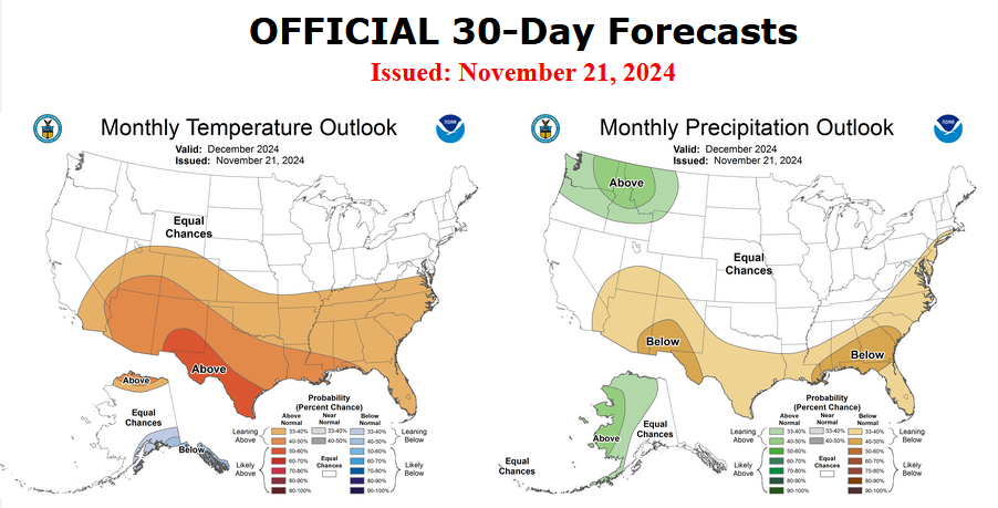
Here is the updated Outlook for November 2024.

For Comparison Purposes, Here is the earlier Mid-Month Outlook for November

It is important to remember that the maps show deviations from the current definition of normal which is the period 1991 through 2020.  So this is not a forecast of the absolute value of temperature or precipitation but the change from what is defined as normal or to use the technical term climatology.

It is a substantial change from what was issued on October 17, 2024. Remember, it is the first set of maps that are the current outlook for November which is the new month.  One expects some changes  14 days later. However, the changes to the updated new month Outlook are very significant.  This then gives us some reason to question the (October 17, 2024) three-month NDJ temperature and precipitation Outlooks which are shown in the following graphic.

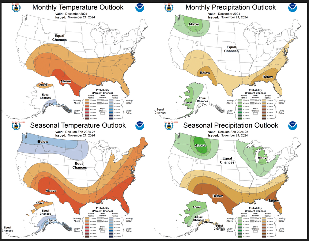
NOAA provided a combination of the Updated Outlook for the New Month and the Three-Month Outlook.

The top pair of maps are again the Updated Outlook for the new month. There is a temperature map and a precipitation map. The bottom row shows the three-month outlooks which includes the new month. I think the outlook maps are self-explanatory.

To the extent that one can rely on a forecast, we would conclude that December and January will be very different than November. You can subtract November from the three-month Outlook and divide by two to get a combined December/January Outlook.

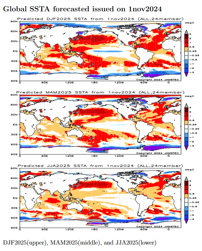
However given the major change in the new Outlook outlook from what was issued on October 17,  2024, we might not trust the three-month Outlook issued on October 17, 2024. Something to think about. But the major factor is the projected slower onset of La Nina. Thus this change may be consistent with the pattern the NOAA has been predicting although they have been playing catch-up.

I am still not convinced that there will be a La Nina Winter. Thus I am somewhat skeptical about the NOAA Outlooks.

Some readers may need to click “Read More” to read the rest of the article.  Some will feel that they have enough information. But there is a lot more information in the rest of this article.

Weather Outlook for the U.S. for Today Through at Least 22 Days and a Six-Day Forecast for the World: posted November 1, 2024

This article focuses on what we are paying attention to in the next 48 to 72 hours. The article also includes weather maps for longer-term U.S. outlooks (up to four weeks) and a six-day World weather outlook which can be very useful for travelers.

First the NWS Short Range Forecast. The afternoon NWS text update can be found here after about 4 p.m. New York time but it is unlikely to have changed very much from the morning update. The images in this article automatically update.

Short Range Forecast Discussion
NWS Weather Prediction Center College Park MD
Fri Nov 01 2024
Valid 12Z Fri Nov 01 2024 – 12Z Sun Nov 03 2024

…Threat of a heavy rain and severe weather event increasing across the
central to southern Plains throughout the weekend…

…Mountain snow will overspread from the Pacific Northwest into much of
the Intermountain West over the next couple of days with heavy rain today
near the Pacific Northwest coast…

…Much above average temperatures expected across large portions of the
central to eastern U.S. with little rain in sight along the East Coast…

A trailing cold front in connection with a low pressure system currently
moving east across the Great Lakes toward New England will bring a chance
of rain into the eastern U.S. on this first day of November following an
exceptionally dry October for this part of the country. However, it
appears that the rain will not progress much beyond the Appalachians today
as another day of warm and dry conditions is forecast for the East Coast.
In fact, the warm temperatures into the 70s early this morning have
already challenged high temperature records for November in upstate New
York. In addition, record high morning lows are possible this morning
from the Mid-Atlantic into New England and record high temperatures are
possible Friday afternoon from near New York City to northern Maine. The
cold front will bring gusty winds and cool temperatures into the Northeast
by tonight and into the weekend. While less record temperatures are
forecast over the next few days across the eastern two-thirds of the
country, widespread above average temperatures expected across large
portions of the central to eastern U.S.

A high pressure system will build across the Northeast during the weekend
and will sustain the dry conditions down the Eastern Seaboard for the
first few days of November. Attention will then focus across the central
and southern Plains as a rather significant heavy rain and severe weather
event will be emerging throughout the weekend. As moist air from the Gulf
of Mexico returns and streams northward into the southern Plains behind
the high pressure system, a deepening upper-level trough will be moving
through the western U.S. This trough will bring another round of heavy
rain near the coast for Pacific Northwest today before spreading more
mountain snow across the Intermountain West through the weekend.
Southwesterly flow ahead of the trough will then interact with the
returning Gulf moisture over the southern Plains and lift the moisture
over a warm front. It appears that moderate to heavy rain associated with
organized thunderstorms will first develop over the southern High Plains
tonight. The thunderstorms and heavy rain will then expand northeastward
into the central Plains through the weekend. A few inches of heavy rain
with locally higher amounts is forecast across the southern Plains, with
the heaviest rains expected across central Oklahoma. Similar to many
areas of the Lower 48, this region is experiencing moderate to extreme
drought conditions. While this round of heavy rain will help aleviate the
drought, the high rainfall rates will also bring an increasing threat of
flash flooding. Please keep abreast of the latest forecast updates on
this upcoming heavy rain/severe weather event across the central to
southern Plains.

To get your local forecast plus active alerts and warnings click HERE and enter your city, state or zip code.

Learn about wave patterns HERE.

Then, looking at the world and of course, the U.S. shows here also. Today we are looking at precipitation.

Please click on “Read More” below to access the full Daily Report issued today.

Weather Outlook for the U.S. for Today Through at Least 22 Days and a Six-Day Forecast for the World: posted October 31, 2024

This article focuses on what we are paying attention to in the next 48 to 72 hours. The article also includes weather maps for longer-term U.S. outlooks (up to four weeks) and a six-day World weather outlook which can be very useful for travelers.

First the NWS Short Range Forecast. The afternoon NWS text update can be found here after about 4 p.m. New York time but it is unlikely to have changed very much from the morning update. The images in this article automatically update.

Short Range Forecast Discussion
NWS Weather Prediction Center College Park MD
Thu Oct 31 2024
Valid 12Z Thu Oct 31 2024 – 12Z Sat Nov 02 2024

…Moderate to heavy snow over parts of the Southern Cascades and Northern
Intermountain Region, with a second area over parts of the Upper Midwest
on Thursday…

…Temperatures will be 20 to 25 degrees above average over parts of the
Lower Great Lakes/eastern Ohio Valley and the Northeast/Mid-Atlantic…

…There is a Marginal Risk of severe thunderstorms over parts of the
Ohio/Tennessee Valley and Lower Mississippi Valley and a Marginal Risk of
excessive rainfall over parts of the Lower Mississippi Valley on
Thursday…

A wave of low pressure over the Upper/Middle Mississippi Valley will move
northeastward to Southeastern Canada by Friday. The trailing front moves
off the Northeast/Mid-Atlantic Coast by Friday evening, while the western
end of the boundary slowly moves northward as a stationary front over
north-central Texas by Saturday. Ahead of the front, temperatures will be
20 to 25 degrees above average over parts of the Lower Great Lakes/eastern
Ohio Valley and the Northeast/Mid-Atlantic.

On Thursday, moist air flowing northward over the Plains will extend into
the Great Lakes, creating showers and strong to severe thunderstorms ahead
of the front over parts of the Ohio/Tennessee Valley and Lower Mississippi
Valley. Therefore, the SPC has issued a Marginal Risk (level 1/5) of
severe thunderstorms over the Ohio/Tennessee Valley and Lower Mississippi
Valley through Friday morning. The hazards associated with these
thunderstorms are frequent lightning, severe thunderstorm wind gusts,
hail, and a minimal threat of tornadoes.

Furthermore, moderate to heavy rain will develop along the front over
parts of Tennessee and Lower Mississippi Valleys. Therefore, through
Friday morning, the WPC has issued a Marginal Risk (level 1/4) of
excessive rainfall over parts of the Tennessee and Lower Mississippi
Valleys. The associated heavy rain will create localized areas of flash
flooding, affecting areas that experience rapid runoff with heavy rain.

Moreover, the wave of low pressure will pull cold air over parts of the
Upper Midwest, producing moderate to heavy snow over parts of Minnesota,
extreme northern Wisconsin, and portions of the Upper Peninsula of
Michigan. Furthermore, rain develops along the front from Central
Appalachians to the Northeast on Friday morning, tapering off to scattered
rain over parts of the Northeast by Friday evening. Also, on Friday,
onshore flow off the Atlantic will produce scattered rain over parts of
Florida.

On Friday, the threat of strong to severe thunderstorms moves westward to
the Southern High Plains as upper-level dynamics move over Southern
California. Therefore, the SPC has issued a Marginal Risk (level 1/5) of
severe thunderstorms over parts of the Southern High Plains from Friday
into Saturday morning. The hazards associated with these thunderstorms are
frequent lightning, severe thunderstorm wind gusts, hail, and a minimal
threat of tornadoes

Further, the showers and thunderstorms will create moderate to heavy rain
over parts of the Southern Plains. Therefore, the WPC has issued a
Marginal Risk (level 1/4) of excessive rainfall over parts of the Southern
Plains from Friday to Saturday morning. The associated heavy rain will
create localized areas of flash flooding, affecting areas that experience
rapid runoff with heavy rain.

Meanwhile, another front over the Pacific Northwest and California will
move inland and dissipate by Thursday evening. On Thursday, the snow will
become moderate to heavy over parts of the Southern Cascades and Northern
Intermountain Region. Rain will continue over the Northwest and
Northern/Central California through early Saturday. Light snow will
continue over parts of the higher elevations of the Cascades, Sierra
Nevada Mountains, Northern Intermountain Region, and Northern Rockies.

To get your local forecast plus active alerts and warnings click HERE and enter your city, state or zip code.

Learn about wave patterns HERE.

Then, looking at the world and of course, the U.S. shows here also. Today we are looking at precipitation.

Please click on “Read More” below to access the full Daily Report issued today.

Weather Outlook for the U.S. for Today Through at Least 22 Days and a Six-Day Forecast for the World: posted October 30, 2024

This article focuses on what we are paying attention to in the next 48 to 72 hours. The article also includes weather maps for longer-term U.S. outlooks (up to four weeks) and a six-day World weather outlook which can be very useful for travelers.

First the NWS Short Range Forecast. The afternoon NWS text update can be found here after about 4 p.m. New York time but it is unlikely to have changed very much from the morning update. The images in this article automatically update.

Short Range Forecast Discussion
NWS Weather Prediction Center College Park MD
Wed Oct 30 2024
Valid 12Z Wed Oct 30 2024 – 12Z Fri Nov 01 2024

…Moderate to heavy snow over parts of the Southern Cascades and Northern
Intermountain Region with a second area over parts of the Upper Midwest on
Thursday…

…Temperatures will be 20 to 30 degrees above average over parts of the
Great Lakes/Ohio Valley…

…There is an Enhanced Risk of severe thunderstorms over parts of the
Middle Mississippi Valley and Central/Southern Plains on Wednesday…

A wave of low pressure along a front over the Southern High Plains will
move northeastward to eastern Quebec, Canada, by Friday. Ahead of the
front, temperatures will be 20 to 30 degrees above average over parts of
the Great Lakes/Ohio Valley. A warm front over Northern New England will
move northeastward into Southeastern Canada by Thursday. Ahead of the warm
front, rain will develop over parts of Northern New England, ending by
Wednesday evening.

On Wednesday, moist air flowing northward over the Plains will extend into
the Upper Great Lakes, creating showers and severe thunderstorms will
develop ahead of the front over parts of the Middle Mississippi Valley and
Central/Southern Plains. Therefore, the SPC has issued an Enhanced Risk
(level 3/5) of severe thunderstorms over the Central Plains through
Saturday morning. The hazards associated with these thunderstorms are
frequent lightning, severe thunderstorm wind gusts, hail, and a few
tornadoes.

Moreover, southeasterly flow off the Gulf of Mexico will create scattered
showers and thunderstorms over parts of the Western Gulf Coast from
Tuesday into Wednesday. Similarly, easterly flow off the Atlantic will
produce showers and thunderstorms over parts of Florida through Thursday
morning. In addition, there is an increased threat of EF2 � EF5
tornadoes over the areas.

Furthermore, moderate to heavy rain will develop along the front over
parts of the Mississippi Valley and the Central/Southern Plains.
Therefore, the WPC has issued a Marginal Risk (level 1/4) of excessive
rainfall over parts of the Mississippi Valley and parts of the
Central/Southern Plains through Thursday morning. The associated heavy
rain will create localized areas of flash flooding, affecting areas that
experience rapid runoff with heavy rain.

On Thursday, the threat of severe thunderstorms from the Great Lakes to
the Lower Mississippi Valley will decrease to strong to severe
thunderstorms. Therefore, the SPC has issued a Marginal Risk (level 1/5)
of severe thunderstorms over parts of the Great Lakes to the Lower
Mississippi Valley from Thursday into Friday morning. The hazards
associated with these thunderstorms are frequent lightning, severe
thunderstorm wind gusts, hail, and a few tornadoes.

Further, the showers and thunderstorms will create heavy rain over parts
of the Tennessee and Lower Mississippi Valleys. Therefore, the WPC has
issued a Marginal Risk (level 1/4) of excessive rainfall over parts of the
Tennessee and Lower Mississippi Valleys from Thursday to Friday morning.
The associated heavy rain will create localized areas of flash flooding,
affecting areas that experience rapid runoff with heavy rain. In addition,
onshore flow from the Gulf of Mexico and the Atlantic will produce showers
and thunderstorms over parts of the Central/Western Gulf Coast and Florida.

Moreover, the wave of low pressure will pull cold air over parts of the
Upper Midwest, producing moderate to heavy snow over parts of Minnesota,
extreme northern Wisconsin, and the western portions of the Upper
Peninsula of Michigan. All these areas will be near Lake Superior on
Thursday, tapering off by Friday.

Meanwhile, another front will come onshore over the Pacific Northwest and
California on Wednesday, dissipating by Thursday evening. From late
Wednesday morning into Friday, the system will produce rain and
higher-elevation snow over parts of the Northwest into Northern/Central
California. On Thursday, the snow will become moderate to heavy over parts
of the Southern Cascades and Northern Intermountain Region.

To get your local forecast plus active alerts and warnings click HERE and enter your city, state or zip code.

Learn about wave patterns HERE.

Then, looking at the world and of course, the U.S. shows here also. Today we are looking at precipitation.

Please click on “Read More” below to access the full Daily Report issued today.

Weather Outlook for the U.S. for Today Through at Least 22 Days and a Six-Day Forecast for the World: posted October 29, 2024

This article focuses on what we are paying attention to in the next 48 to 72 hours. The article also includes weather maps for longer-term U.S. outlooks (up to four weeks) and a six-day World weather outlook which can be very useful for travelers.

First the NWS Short Range Forecast. The afternoon NWS text update can be found here after about 4 p.m. New York time but it is unlikely to have changed very much from the morning update. The images in this article automatically update.

Short Range Forecast Discussion
NWS Weather Prediction Center College Park MD
Tue Oct 29 2024
Valid 12Z Tue Oct 29 2024 – 12Z Thu Oct 31 2024

…Moderate to heavy snow over parts of the Northern/Central Rockies on
Tuesday…

…Temperatures will be 20 to 35 degrees above average over parts of the
Central Plains to the Great Lake/Ohio Valley…

…There is a Slight Risk of severe thunderstorms over parts of the
Middle/Lower Mississippi Valley and Central/Southern Plains on Wednesday…

A wave of low pressure along a front over the Great Basin/Central Rockies
will move northeastward to the Upper Mississippi Valley by Thursday. Ahead
of the front, temperatures will be 20 to 35 degrees above average over
parts of the Central Plains to the Great Lake/Ohio Valley. A warm front
extending from the Upper Mississippi Valley to the Ohio Valley moves
northeastward into Eastern Canada by Wednesday. Ahead of the warm front,
showers and thunderstorms will develop over parts of the Great Lakes,
ending by Tuesday afternoon. On Tuesday evening, rain will develop over
parts of the Lower Great Lakes/Northeast and continue into Wednesday
afternoon.

On Tuesday, a wave of low pressure will produce moderate to heavy snow
over parts of the Northern/Central Rockies and higher elevations of the
eastern Great Basin. Rain will also develop over parts of the lower
elevations of the Southwest, Great Basin, and Central Rockies.

Moreover, weak onshore flow off the Pacific will produce rain over parts
of the Pacific Northwest through late Tuesday evening. Light snow will
continue on Wednesday over parts of the Northern/Central Rockies through
late Wednesday night.

Meanwhile, southeasterly flow off the Gulf of Mexico will create scattered
showers and thunderstorms over parts of the Western Gulf Coast on Tuesday
into Wednesday. Similarly, easterly flow off the Atlantic will produce
showers and thunderstorms over parts of Florida through Thursday morning.

Further, moist air flowing northward over the Plains will extend into the
Upper Great Lakes on Wednesday, creating showers and thunderstorms over
parts of the Northern Plains and Upper Mississippi Valley. Showers and
strong to severe thunderstorms will develop ahead of the front over parts
of the Middle Mississippi Valley to the Central/Southern Plains.
Therefore, the SPC has issued a Marginal Risk (level 1/5) of severe
thunderstorms over parts of the Middle Mississippi Valley to
Central/Southern Plains through Wednesday morning. The hazards associated
with these thunderstorms are frequent lightning, severe thunderstorm wind
gusts, hail, and a minimal threat of tornadoes.

On Wednesday, showers and severe thunderstorms will develop along and
ahead of the front over parts of the Middle/Lower Mississippi Valley and
Central/Southern Plains. Therefore, the SPC has issued a Slight Risk
(level 2/5) of severe thunderstorms over these areas from Wednesday
through Thursday morning. The hazards associated with these thunderstorms
are frequent lightning, severe thunderstorm wind gusts, hail, and a few
tornadoes.

Furthermore, moderate to heavy rain will develop along the front parts of
the Mississippi Valley and the Central/Southern Plains. Therefore, the WPC
has issued a Marginal Risk (level 1/4) of excessive rainfall over parts of
the Mississippi Valley and parts of the Central/Southern Plains from
Wednesday through Thursday morning. The associated heavy rain will create
localized areas of flash flooding, affecting areas that experience rapid
runoff with heavy rain.

Elsewhere, another front will come onshore over the Pacific Northwest and
California on Wednesday into early Thursday morning. The system will
produce rain and higher-elevation snow over parts of the Northwest into
Northern/Central California.

To get your local forecast plus active alerts and warnings click HERE and enter your city, state or zip code.

Learn about wave patterns HERE.

Then, looking at the world and of course, the U.S. shows here also. Today we are looking at precipitation.

Please click on “Read More” below to access the full Daily Report issued today.

Weather Outlook for the U.S. for Today Through at Least 22 Days and a Six-Day Forecast for the World: posted October 28, 2024

This article focuses on what we are paying attention to in the next 48 to 72 hours. The article also includes weather maps for longer-term U.S. outlooks (up to four weeks) and a six-day World weather outlook which can be very useful for travelers.

First the NWS Short Range Forecast. The afternoon NWS text update can be found here after about 4 p.m. New York time but it is unlikely to have changed very much from the morning update. The images in this article automatically update.

Short Range Forecast Discussion
NWS Weather Prediction Center College Park MD
Mon Oct 28 2024
Valid 12Z Mon Oct 28 2024 – 12Z Wed Oct 30 2024

…Moderate to heavy snow over parts of the Northern/Central Rockies on
Tuesday…

…Temperatures will be 20 to 30 degrees above average over parts of the
Plains and Mississippi Valley…

…There is a Marginal Risk of severe thunderstorms over parts of the
Upper/Middle Mississippi Valley and Central/Southern Plains on Tuesday…

A front extending from the Northern Plains to the Great Basin and Southern
California will move eastward to the Upper Mississippi Valley/Upper Great
Lakes southwestward to the Southern High Plains by Wednesday. Ahead of the
front, temperatures will be 20 to 30 degrees above average over parts of
the Plains and Mississippi Valley.

In the wake of the front, onshore flow off the Pacific will produce rain
over the Pacific Northwest and Northern California through Tuesday night.
In addition, scattered light snow will develop over the highest elevations
of the Cascades, the Sierra Nevada Mountains, the Northern Intermountain
Region, and the Great Basin through Wednesday. Lower-elevation rain will
also develop over parts of the Great Basin, Southwest, and
Northern/Central Rockies.

Further, intensifying upper-level energy over the Four Corners Region will
aid in producing moderate to heavy snow over parts of the Northern/Central
Rockies and higher elevations of the eastern Great Basin on Tuesday.

Meanwhile, southeasterly flow off the Gulf of Mexico will create scattered
rain over parts of the Western Gulf Coast on Monday. On Tuesday, the
atmosphere along the Western Gulf Coast will become more unstable, so
showers and thunderstorms will develop over parts of the Western Gulf
Coast. Similarly, easterly flow off the Atlantic will produce rain over
parts of Florida on Monday. On Tuesday, the atmosphere will become more
unstable, so showers and thunderstorms will develop over parts of Florida.

Moreover, moist air will pool ahead of the front over the Great Lakes on
Monday, creating showers and thunderstorms. Rain will develop over parts
of the Northeast on Tuesday into Wednesday morning and also over parts of
the Northern/Central Plains and Upper Mississippi Valley on Tuesday.

Additionally, moisture will pool along the boundary over parts of the
Upper/Middle Mississippi Valley to Central/Southern Plains, producing
strong to severe thunderstorms. Therefore, the SPC has issued a Marginal
Risk (level 1/5) of severe thunderstorms over parts of the Upper/Middle
Mississippi Valley to Central/Southern Plains from Tuesday into Wednesday
morning. The hazards associated with these thunderstorms are frequent
lightning, severe thunderstorm wind gusts, hail, and a minimal threat of
tornadoes.

To get your local forecast plus active alerts and warnings click HERE and enter your city, state or zip code.

Learn about wave patterns HERE.

Then, looking at the world and of course, the U.S. shows here also. Today we are looking at precipitation.

Please click on “Read More” below to access the full Daily Report issued today.

Weather Outlook for the U.S. for Today Through at Least 22 Days and a Six-Day Forecast for the World: posted October 27, 2024

This article focuses on what we are paying attention to in the next 48 to 72 hours. The article also includes weather maps for longer-term U.S. outlooks (up to four weeks) and a six-day World weather outlook which can be very useful for travelers.

First the NWS Short Range Forecast. The afternoon NWS text update can be found here after about 4 p.m. New York time but it is unlikely to have changed very much from the morning update. The images in this article automatically update.

Short Range Forecast Discussion
NWS Weather Prediction Center College Park MD
Sun Oct 27 2024
Valid 12Z Sun Oct 27 2024 – 12Z Tue Oct 29 2024

…Scattered light rain will develop over the Carolinas…

…Rain and higher elevation snow over parts of the Northeast Sunday
night…

…Rain moves into the Northwest and light snow over the higher elevations
of the Western States…

A front lingering along the Gulf Coast States will slowly dissipate by
Monday. Upper-level impulses over the Ohio and Lower Mississippi Valleys
will produce scattered rain over parts of the Lower Mississippi Valley
through late Sunday morning. In addition, upper-level dynamics will
develop light rain over parts of the Carolinas early Sunday through early
Monday morning. Furthermore, onshore flow off the Atlantic will create
scattered rain over parts of Florida from Monday afternoon through Tuesday.

Meanwhile, a front over the Pacific Northwest will move inland to the
Upper Mississippi Valley to the Central Plains and then to the Southwest
by Tuesday. The storm will produce rain over parts of the Pacific
Northwest and Northern California through Sunday afternoon. Onshore flow
off the Pacific will produce rain over the Pacific Northwest and Northern
California through Monday night. As the front passes over the Northwest
into the Great Basin, scattered light snow will develop over the highest
elevations of the Cascades, the Sierra Nevada Mountains, the Northern
Intermountain Region, and the Great Basin through Tuesday.

As the leading edge of the boundary moves into the Upper Midwest, rain
with embedded thunderstorms will develop over parts of the Great Lakes
from Monday evening into Tuesday. Furthermore, ahead of the front,
temperatures will be 10 to 25 degrees above average over the Plains.

Elsewhere, a front will move southward out of Central Canada on Sunday,
advancing into the Northeast by Sunday evening and then out over the
Atlantic. This front will produce scattered rain and snow over the higher
elevations of the Northeast through early Monday morning.

To get your local forecast plus active alerts and warnings click HERE and enter your city, state or zip code.

Learn about wave patterns HERE.

Then, looking at the world and of course, the U.S. shows here also. Today we are looking at precipitation.

Please click on “Read More” below to access the full Daily Report issued today.

Looking Back at September 2024 Weather for the U.S. and the World – Posted on October 26, 2024

Much of the information in this report comes from the monthly emails I receive from John Bateman. He does public outreach for NOAA and in particular NCEI. I could find the same information and more on the NCEI website but John Bateman produces a good summary so I use it or most of it. I also add additional information from NCEI or other NOAA websites. At the end of the article, I provide links that will get you to the full reports and much additional information. This month NCEI which is based in North Carolina had a lot of computer problems so the email from John Bateman  is combined  U.S. and World and not as complete as usual.

 My comments if any are in boxes like this one.

I start with the trends of September 2024 Temperature looking at North America and then the World both land and water. There is a graphic for just CONUS but the format is different and it is not as easy to read.

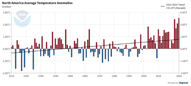
This is the temperature trend for the month of  September in North America. It covers a larger geographical area than just CONUS but I find it easier to read. It looks like the September temperature was a record.

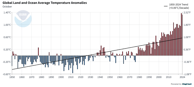
The temperature for the world, land and ocean did not hit a new record.

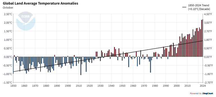
The temperature for the world, (land only) also did not hit a new record. Notice that land temperatures increase faster than land and ocean as water takes more energy.

To read the rest of this article some will have to click on “Read More”.

Weather Outlook for the U.S. for Today Through at Least 22 Days and a Six-Day Forecast for the World: posted October 26, 2024

This article focuses on what we are paying attention to in the next 48 to 72 hours. The article also includes weather maps for longer-term U.S. outlooks (up to four weeks) and a six-day World weather outlook which can be very useful for travelers.

First the NWS Short Range Forecast. The afternoon NWS text update can be found here after about 4 p.m. New York time but it is unlikely to have changed very much from the morning update. The images in this article automatically update.

Short Range Forecast Discussion
NWS Weather Prediction Center College Park MD
Sat Oct 26 2024
Valid 12Z Sat Oct 26 2024 – 12Z Mon Oct 28 2024

..Showers and thunderstorms over parts of the Lower Mississippi/Ohio
Valleys on Saturday…

…Rain and higher elevation snow over parts of the Northeast Sunday
night…

…Rain moves into the Pacific Northwest and light snow over the higher
elevations of the Cascades and Northern Intermountain Region…

A front extending from the Northeast Coast to the Mid-Atlantic and then
westward to the Southern Plains moves eastward over the Atlantic while the
western end of the boundary lingers over the Gulf Coast States through
Monday. In the wake of the front, scattered light rain will develop over
parts of the Northeast through Saturday night. Along the southern edge of
the boundary, scattered showers and thunderstorms will develop over parts
of the Lower Mississippi/Ohio Valleys through Saturday evening. Light rain
will develop over parts of the Carolinas early Sunday through early Monday
morning. Furthermore, onshore flow off the Atlantic will create scattered
rain over parts of Florida through Saturday afternoon/evening.

Meanwhile, a front will move onshore over the Pacific Northwest Saturday
morning, moving inland to the Northern Plains and the Great Basin by
Monday. The storm will produce rain over parts of the Pacific Northwest
through Monday. The rain will move into Northern California late Saturday
evening and continue into Sunday evening. Additionally, overnight Sunday,
light snow will develop over the highest elevations of the Cascades and
the Northern Intermountain Region.

Elsewhere, a front will move southward out of Central Canada on Sunday
morning, advancing into the Northeast by Sunday evening, producing
scattered rain and snow over the higher elevations of the Northeast
through Sunday night.

To get your local forecast plus active alerts and warnings click HERE and enter your city, state or zip code.

Learn about wave patterns HERE.

Then, looking at the world and of course, the U.S. shows here also. Today we are looking at precipitation.

Please click on “Read More” below to access the full Daily Report issued today.

Weather Outlook for the U.S. for Today Through at Least 22 Days and a Six-Day Forecast for the World: posted October 25, 2024

This article focuses on what we are paying attention to in the next 48 to 72 hours. The article also includes weather maps for longer-term U.S. outlooks (up to four weeks) and a six-day World weather outlook which can be very useful for travelers.

First the NWS Short Range Forecast. The afternoon NWS text update can be found here after about 4 p.m. New York time but it is unlikely to have changed very much from the morning update. The images in this article automatically update.

Short Range Forecast Discussion
NWS Weather Prediction Center College Park MD
Fri Oct 25 2024
Valid 12Z Fri Oct 25 2024 – 12Z Sun Oct 27 2024

…Showers and thunderstorms over parts of the Middle Mississippi/ Ohio
Valleys…

…Rain over parts of the Northeast…

…Rain moves into the Pacific Northwest…

A wave of low pressure over the Middle Mississippi Valley will move
northeastward off the Northeast Coast by Saturday evening. The system will
produce showers and thunderstorms over parts of the Middle
Mississippi/Ohio Valleys through Friday evening. The system will also
create rain over parts of the Great Lakes through Saturday afternoon.
Overnight Friday, scattered rain will develop over parts of the Northeast
through early Sunday morning. Moreover, scattered rain will develop along
the front over the Southern Mid-Atlantic from Saturday evening into
Sunday. Rain will also grow over parts of the Lower Mississippi Valley
from early Saturday into Sunday.

Meanwhile, a front will move onshore over the Pacific Northwest Friday
night and inland through Sunday morning. The storm will produce rain over
parts of the Pacific Northwest late Friday night. The rain will continue
to inch farther inland on Saturday, moving into Northern California late
Saturday night and continuing into Sunday.

Elsewhere, onshore flow off the Atlantic will trigger scattered rain over
parts of Florida from Saturday afternoon into Sunday.

To get your local forecast plus active alerts and warnings click HERE and enter your city, state or zip code.

Learn about wave patterns HERE.

Then, looking at the world and of course, the U.S. shows here also. Today we are looking at precipitation.

Please click on “Read More” below to access the full Daily Report issued today.