This article focuses on what we are paying attention to in the next 48 to 72 hours. The article also includes weather maps for longer-term U.S. outlooks and a six-day World weather outlook which can be very useful for travelers.
First the highlights from the NWS.
Short Range Forecast Discussion
NWS Weather Prediction Center College Park MD
Tue Jan 02 2024
Valid 12Z Tue Jan 02 2024 – 12Z Thu Jan 04 2024…Pacific system to bring coastal/lower elevation rain and mountain snows
to California and the Pacific Northwest Tuesday, spreading into the Great
Basin and Southwest Wednesday……Moderate to locally heavy rainfall expected with showers and
thunderstorms for portions of Texas and the Gulf Coast……Lake-effect snows downwind from the Great Lakes over the next couple of
days…
For those who may have missed the January update, here is the key graphic.
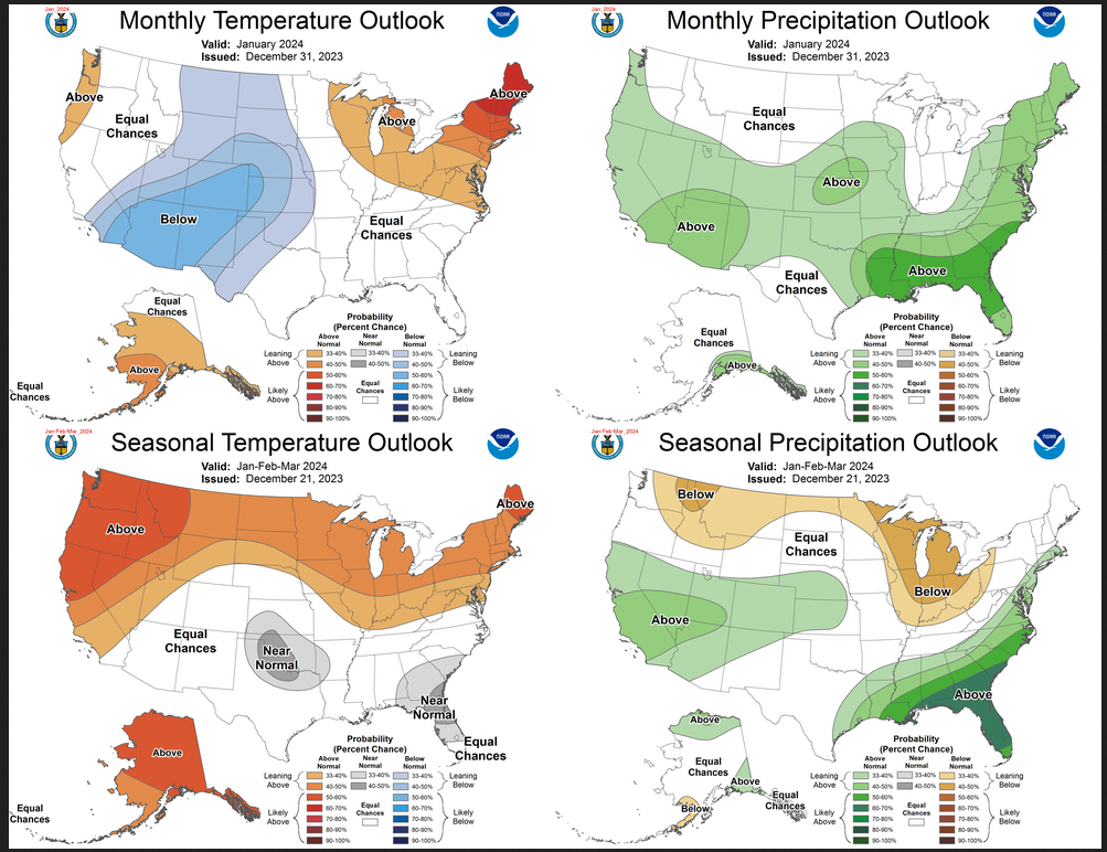
| I provide the link to the full report published on Monday in the body of this article. The above shows in the top row the updated outlook for January. The bottom row is the three-month outlook issued on December 21. Do I think that outlook is still valid? I have to say no. The changes made to the January Outlook raise questions about the three-month outlook. But NOAA says the changes were due to the MJO and AO. The MJO will not impact February and March based on what happened in January. It is not clear if the changes to the AO will carry into subsequent months. And it is not clear that the changes in the outlook were fully explained in the discussion issued with the updated outlook. So we will be in suspense until the new Seasonal Outlook is issued on January 18, 2024. |
Please click on “Read More” below to access the full report issued today with some additional comments on the article issued yesterday.
| Notices: The article on the Updated Outlook can be accessed HERE. It contains a lot of useful information. But it is important to remember that the daily article always shows the NOAA (actually the CPC) outlooks through weeks 3 – 4. The week 3-4 outlook is only updated in my article on Fridays. This is what I mean by the intermediate-term outlooks. The end-of-the-month article for which I provided a link above, organizes the information in a very useful way. Most of that information can be found in the daily article but it may take a little exploration of the links provided in the daily article which is why I publish the NOAA end-of-month update for the subsequent month.
What would you like to learn about? Please provide that to me via the comment section at the end of the article. |
Now more detail on the 48-Hour Forecast (It is a 48 to 72 Hour Forecast actually)
Daily weather maps. The Day 1 map updates twice a day and the Day 2 and 3 maps update only once a day. These maps update automatically. But if that does not happen, you can get updates by clicking HERE
TODAY (or late in the day the evening/overnight map will appear) (Key to surface fronts shown on maps and you will then also be able to insert a city name or zip code and get a local NWS forecast).
TOMORROW
NEXT DAY
This animation shows how things may play out over the next 60 hours. To update click here.
The NWS Climate Prediction Center’s: Watches, Warnings, and Advisories plus other information can be found HERE. We post at least one of those updates daily, sometimes both. The Highlights are shown in the lede paragraph of this article.
ATMOSPHERIC RIVERS
This tells us what is approaching the West Coast. Click HERE to update If I have not gotten around to doing the update. Here is some useful information about Atmospheric Rivers.
Continuation of the NWS Short Range Forecast. It is updated by NWS twice a day and these updates can be found here
After a mostly quiet start to the new year, the weather pattern will get
more active across multiple areas of the country as we start the shortened
work week. A Pacific storm system approaching the West Coast Tuesday
morning will bring moderate to locally heavy rain to coastal and lower
elevations of the Pacific Northwest and California, as well as some
potentially heavy snow for higher mountain elevations. The heaviest
rainfall is most likely along the northern California coast where totals
above an inch will be possible. In the mountains, higher elevations of the
Northern Coastal Ranges, Klamath Mountains, and the Sierra will see
moderate to locally heavy snow with totals of 6-12″, locally higher.
Precipitation chances will shift south and eastward Wednesday into
southern California, the Great Basin, and the Southwest. Rain is forecast
for coastal southern California and the Desert Southwest with a wintry mix
for lower elevation valleys in the Great Basin, though little to no snow
accumulations are anticipated. Higher elevations in the mountains will
likely see at least a few inches of snow, including for those in southern
California and the greater Los Angeles area and into the Southwest.To the east, an upper-level shortwave will help to induce a surface low
pressure system along a frontal boundary in the Gulf, drawing Gulf
moisture northward into Texas and along the Gulf Coast and leading to
scattered to widespread showers and thunderstorms. Some moderate to
locally heavy rainfall will be possible for portions of central and
eastern Texas beginning Tuesday afternoon, spreading eastward through the
Lower Mississippi Valley Tuesday night and into the Southeast Wednesday.
The highest chances for heavier rainfall will be focused along the Gulf
Coast.A frontal wave dropping southward from Canada and predominantly
northwesterly wind flow will lead to some lake-enhanced and lake-effect
snow showers downwind from the Great Lakes over the next couple of days.
Accumulations of a few inches are expected for favorable regions
south/east of Lakes Superior and Michigan Tuesday, shifting to areas east
of Lakes Erie and Ontario Wednesday. Some locally heavier totals above 6″
could be seen east of Lakes Erie and Ontario depending upon the intensity
and longevity of the snowbands.Elsewhere, conditions will be mostly dry. Forecast high temperatures will
generally be near or above early January averages along the northern tier
of the country from the Northern Plains through the Great Lakes and into
the Northeast, as well as for the Interior West, Central Plains, and
Middle Mississippi Valley. Conditions will remain below average and a bit
chilly for Texas into the Southeast following a recent frontal passage.
Temperatures will also fall below average Wednesday for California and
portions of the Great Basin/Desert Southwest as the Pacific system
continues inland.
Learn about wave patterns HERE.
Below is the current five-day cumulative forecast of precipitation (Updates can be found HERE)
Ski SnowReports
New Feature – Ski Reports. It is difficult to find reports that auto-update on-screen (and they are very long) but these links will get you to them – If you have additional suggestions make them in the comments section after every Econcurrents Article and we may add those links. We will try to not have too much overlap as that can add to the confusion.
Snow Forecasts. And remember this shows natural snow. Ski resorts also make their own snow.
Day 1

Day 2

Additional snow information can be found here and here. The second link provides animations.
Now we look at Intermediate-Term “Outlook” maps for three time periods. Days 6 – 10, Days 8 – 14, and Weeks 3 and 4. An outlook differs from a forecast based on how NOAA uses these terms in that an “outlook” presents information as deviation from normal and the likelihood of these deviations.
Below are the links to obtain updates and additional information. They are particularly useful if you happen to be reading this article significantly later than when it was published. I always try to provide readers with the source of the information in my articles.
| Days 6 – 10 (shown in Row 1) | Days 8 – 14 (Shown in Row 2) | Weeks 3 and 4 (Shown in Row 3 but updates only on Fridays) |
| https://www.cpc.ncep.noaa. gov/products/predictions/610day/ | https://www.cpc.ncep .noaa.gov/products/predictions/814day/ | https://www.cpc.ncep.noaa.gov/products/predictions/WK34/ |
Showing the actual maps. They should now update automatically. The Week 3 – 4 Outlook only updates on Fridays. So below is what I call the Intermediate-term outlook. On Fridays, it extends out 28 Days. That declines day by day so on Thursday it only looks out 22 days until the next day when the Week 3 – 4 Outlook is updated and this extends the outlook by one additional week.
| 6–
10
|
|
|
| 8–
14 |
|
|
| 3–
4 |
|
|
HAZARDS OUTLOOKS
Click here for the latest complete Day 3 -7 Hazards forecast which updates only on weekdays. Once a week probably Monday or Tuesday I will update the images. I provided the link for readers to get daily updates on weekdays. Use your own judgment to decide if you need to update these images. I update almost all the images Friday Night for the weekend edition of this Weather Report. So normally readers do not need to update these images but if the weather is changing quickly you may want to.
Temperature month to date can be found at https://hprcc.unl.edu/products/maps/acis/MonthTDeptUS.png
Precipitation month to date can be found at https://hprcc.unl.edu/products/maps/acis /MonthPNormUS.png
World Forecast
Below are the Day 1 -3 and 4-6 forecasts for temperature and precipitation. Updates and much additional information can be obtained HERE
World Temperature Anomalies
World Accumulated Precipitation
This information is provided by the University of Maine. They draw upon many different sources. There is a lot of information available at the link provided. I have just provided two useful forecasts. There are probably over a hundred different forecasts available from this source.
Worldwide Tropical Forecast (This is a NOAA Product)
This graphic updates on Tuesdays) If it has not been updated, you can get the update by clicking here Readers will only have to do that if they are reading this article much later than the date of it being published.
Information on Tropical Storms can be found HERE. Western Pacific information can be found HERE.
–
| I hope you found this article interesting and useful. |
–
