Updated slightly at 3:16 p.m. EDT March 22, 2023
The mission of the National Weather Service Colorado Basin River Forecast Center (CBRFC) is to produce river, flood and water supply forecasts for the Colorado Basin and the Great Basin in support of saving lives and property and to enhance the region’s environment and economy.
In this article, I am providing a large amount of the material I received in the latest update which they described as a mid-month update.
I have also included information on the current reservoir storage levels.
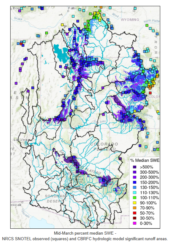
The image below shows the area covered in the CBRFC Report as well as the current snowpack.
March 20, 2023 Water Supply Forecast Discussion
The Colorado Basin River Forecast Center (CBRFC) geographic forecast area includes the Upper Colorado River Basin (UCRB), Lower Colorado River Basin (LCRB), and Eastern Great Basin (GB).
Water Supply Forecast Summary
The active weather pattern that began around mid-February continued through mid-March across the region. Precipitation was above to well above normal across most of the region during the first half of March. March 1-16 precipitation in the UCRB ranged from 80% of normal in the Colorado Headwaters above Kremmling to 275% of normal in the Duchesne River Basin. In the LCRB, March 1-16 precipitation ranged from 110% of normal in the Upper Gila River Basin to 285% of normal in the Virgin River Basin. Precipitation generally exceeded 200% of normal during the first half of March in the GB.
Mid-March snow water equivalent (SWE) conditions are above to much above normal across the CRB and GB. Above normal precipitation during the first half of March led to improvements in percent of normal SWE conditions. Mid-March CBRFC model SWE conditions are 110-210% of normal across the UCRB. Mid-March CBRFC model SWE conditions across the LCRB are much above normal (>200%) and exceeding expectations because La Niña conditions usually result in drier than average winter weather across the southwest US. Mid-March SWE conditions across the GB generally exceed 160% of normal. Around 20 SNOTEL stations across UT are reporting record mid-March SWE values.
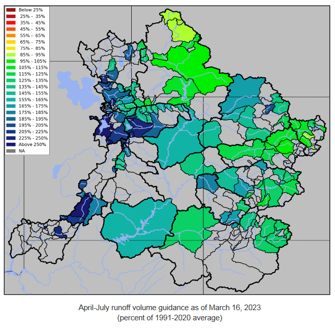
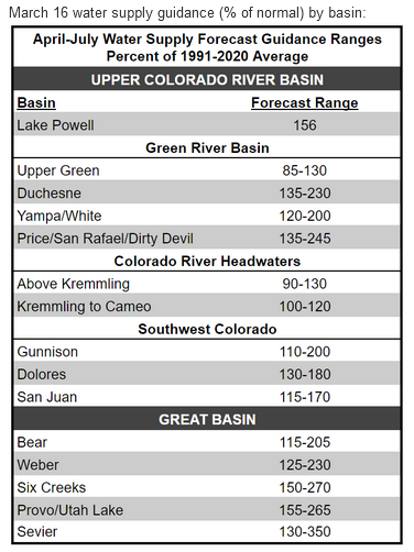
Water supply volume guidance increased in the UCRB and GB during the first half of March as a result of above normal precipitation. Mid-March forecasts of April-July unregulated inflow for some of the major reservoirs in the UCRB include Fontenelle Reservoir 710 KAF (97% average), Flaming Gorge 1100 KAF (114%), Blue Mesa Reservoir 830 KAF (131%), McPhee Reservoir 475 KAF (186%), and Navajo Reservoir 960 KAF (152%). The Lake Powell inflow forecast is 10.0 MAF (156% of average), which is a 2.0 MAF increase from the early March forecast.
Unusually cool and wet weather will continue across the region through the end of this week. Another atmospheric river event will bring significant precipitation to much of the area. By Thursday morning (March 23), the higher elevations of UT, western CO, and AZ are expected to receive at least an inch of precipitation. The heaviest precipitation will occur across central AZ, with a 25% chance that higher elevations of the headwaters of the Verde, Salt, and Little Colorado will receive over three inches of precipitation. High-elevation snowfall totals by Friday morning are expected to be in the 1-2 foot range across northern UT and northwestern CO, 2-5 foot range across southern UT and southwestern CO, and 1-3 foot range across central and northern AZ.
Water Supply Discussion
Water Year 2023 Weather/Precipitation
Snowpack
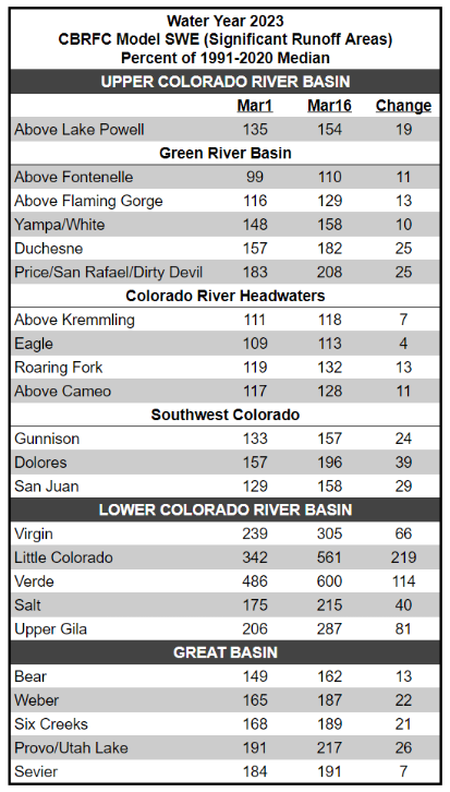
Mid-March snow water equivalent (SWE) conditions are above to much above normal across the CRB and GB. Above normal precipitation during the first half of March led to improvements in percent of normal SWE conditions. Mid-March CBRFC model SWE conditions are 110-210% of normal across the UCRB. SWE conditions along Colorado’s Western Slope are more favorable in the northern (White/Yampa) and southern (Gunnison, Dolores, San Juan) basins compared to Colorado River headwater basins in west-central CO. Most SNOTEL stations in the White/Yampa River Basin are reporting mid-March SWE values that rank in the top five of the station’s record and above the 90th percentile. Mid-March snowpack conditions are least favorable in the far northern Upper Green River Basin above Fontenelle Reservoir and the Colorado River headwaters above Dotsero, where SWE conditions are 110-120% of normal. Across the LCRB, percent of normal SWE can be highly variable due to percentages being computed using smaller values, and precipitation type (rain vs. snow) having a large impact on percent of normal conditions. This year is a good example as winter temperatures across the LCRB have been below normal with more snow than normal observed at lower elevations leading to large percent of normal snowpack conditions. With that said, mid-March CBRFC model SWE conditions across the LCRB are much above normal (>200%) and exceeding expectations because La Niña conditions usually result in drier than average winter weather across the southwest US. More storms and precipitation events have targeted UT this winter compared to southwest WY, and western CO, and SWE conditions in the GB generally reflect better conditions when compared to the UCRB. Mid-March SWE conditions across the GB range from 160% of normal in the Bear River Basin to 215% of normal in the Provo/Utah Lake Basin. A majority of SNOTEL stations in UT are reporting mid-March SWE values that rank in the top five of the station’s record and above the 85th percentile. Around 20 SNOTEL stations across UT are reporting record mid-March SWE values.
March SWE conditions are summarized in the table and figure below.
Showing this in map format

From a Different Source (USBR.gov) and Covering a Larger Area

You can click on the above image to enlarge it.
–
| I hope you found this article interesting and useful. |
–


Sig, another great report. Thank you!
I am glad you liked it. I could publish this article every month but it is more meaningful when we get to the time of year when snowmelt estimates are more meaningful.