Here is what we are paying attention to in the next 48 to 72 hours from Monday Afternoon’s NWS forecast. This article also includes World weather forecasts.
We start with the U.S. Information.
Short Range Forecast Discussion
NWS Weather Prediction Center College Park MD
232 PM EST Mon Jan 09 2023

Valid 00Z Tue Jan 10 2023 - 00Z Thu Jan 12 2023

...More high impact heavy precipitation on tap for much of California on
Tuesday and from northern California into the Pacific Northwest on
Wednesday...

...Heavy snows likely through the Sierra, Wasatch and Central Rockies...

...Arctic air to remain absent from the Lower 48 over the next several
days...
First, the 48-Hour Forecast (It is a 48 to 72 Hour Forecast actually)
Daily weather maps
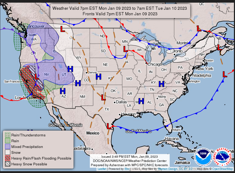
MONDAY EVENING AND OVERNIGHT
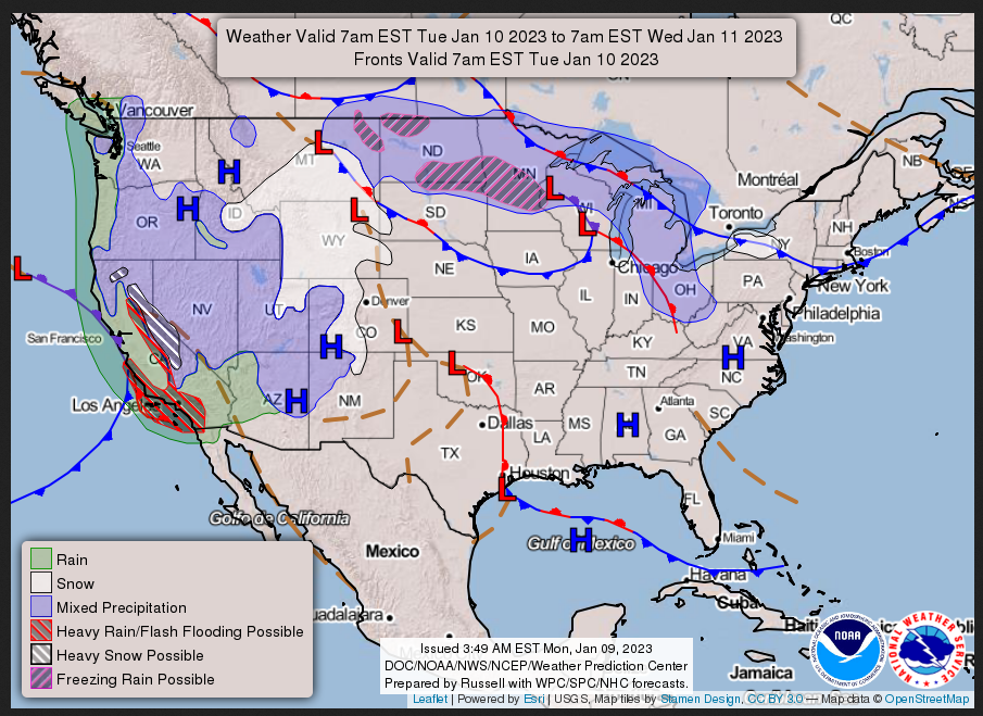
TUESDAY
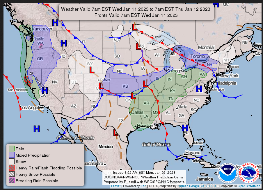
WEDNESDAY
I try to keep the above maps updated. They only update twice a day and in some cases once a day.
I will be doing the updating during the period described in the title of the article but if you happen to read this article later you can get updates by clicking HERE.
This animation shows how things may play out over the next 60 hours. To update click here.
ATMOSPHERIC RIVERS
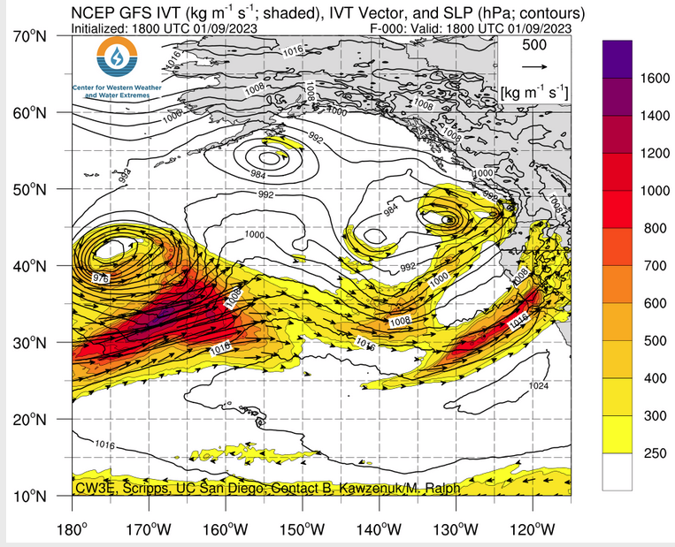
Continuation of the NWS Short Range Forecast (It is updated by NWS twice a day and these updates can be found here. We post at least one of those updates daily, sometimes both. The Highlights are shown in the lede paragraph of this article.
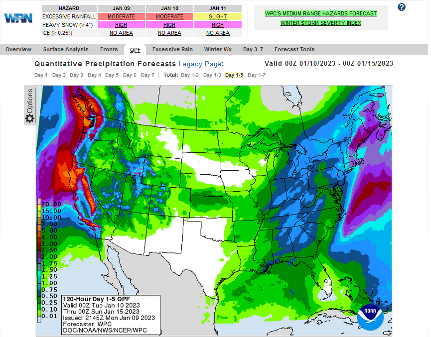
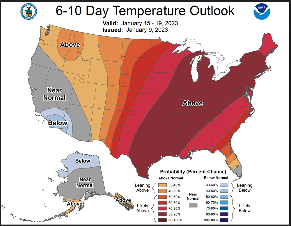
No significant letup expected to the recent very wet weather pattern that
has been plaguing much of California.  The ongoing heavy rains Monday
afternoon across central California will be dropping into Southern
California tonight into early Tuesday.   These heavy rains will pose the
threat of flash flooding and mudslides from Los Angeles to San Diego,
especially across burn scar regions where lessened vegetation increases
the risks.  While areas of Central to Northern California will see some
respite from recent heavy rains later today into early Tuesday, it will be
short lived as the next in the seemingly never ending parade of strong wet
Pacific systems pushes more heavy precipitation across all of California
on Tuesday.  Nearly all of California has seen much above average rainfall
totals over the past several weeks, with totals 400-600% above average
values.  This has resulted in nearly saturated soils and increasingly high
river levels.  Additional heavy rains on Tuesday will exacerbate ongoing
flooding and continue the risk of flash flooding and mudslides, especially
across recent burn scar regions.   The one good aspect of the recent heavy
rains has been relief from the drought that has been persistent across
large portions of the West.  Large portions of California into the Great
Basin have seen 1 to 2 drought class improvements over the past month.
This much above average precipitation is also being seen in reservoir
levels across California.  Many reservoirs are now above their historical
average levels, with water levels increasing rapidly during the past
month.  The Tuesday heavy rain event will wind down Tuesday night across
much of the state.  However, yet another batch of heavy precipitation will
be moving into Northern California and the coastal Pacific Northwest on
Wednesday.  This batch of heavy rains will, however, not make its way
southward into central to southern California.  When all is said and done,
precipitation totals over the next few days will be in the 3-7 inch range
through the Transverse Range of Southern California, northward along the
central to northern California coast ranges and through the Sierra.
Widespread considerable flood impact likely across large portions of
California into western Nevada

Inland, very heavy snows are likely through the Sierras of California, the
 Wasatch of Utah and Central Rockies from Colorado into northwest Wyoming
and far eastern Idaho.  Snowfall totals of 2 to 4 feet likely through the
Sierra and totals of 1 to 2 feet expected through the Wasatch and Central
Rockies region.  The heavy snows, especially through the Sierra will
increase the risk of avalanches and impacts to infrastructure from the
increasing snow load across these area.  Travel will become increasingly
difficult above 4000 feet in central to northern California.

The parade of storms affecting California and the west is indicative of an
overall progressive west to east flow pattern across the Lower 48.  This
will continue to keep arctic air absent from most of the U.S. over the
next several days.  Temperatures are expected to remain above to much
above average across much of the nation this week.  The exception to this
will be across California into the Great Basin and Southwest where the
series of storms and heavy precipitation will result in temperatures
slightly below average.
Below is the current five-day cumulative forecast of precipitation (Updates can be found HERE)
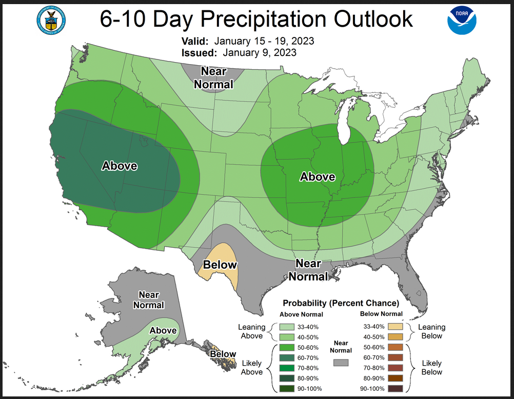
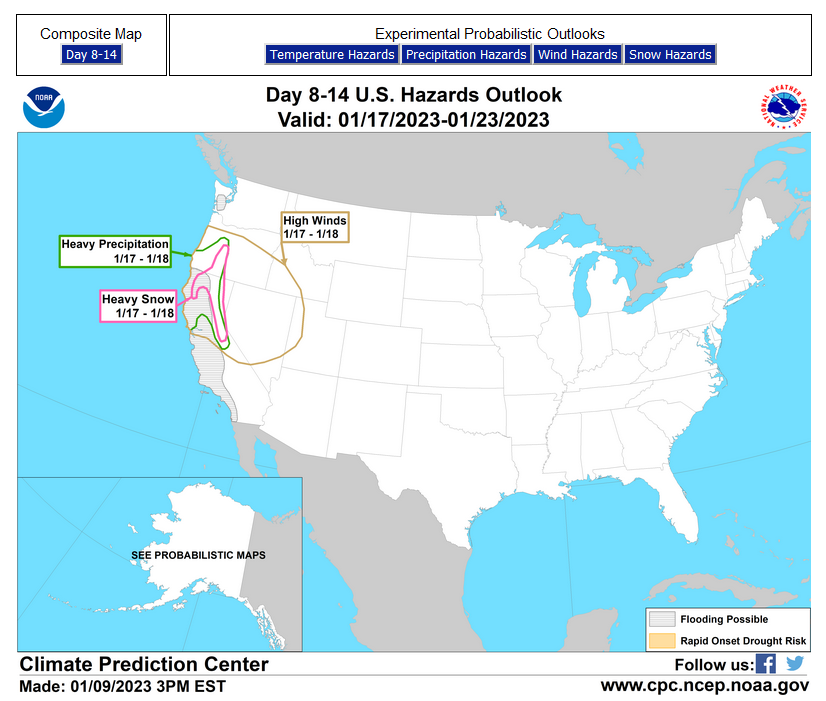
Now we look at Intermediate-Term “Outlook” maps for three time periods. Days 6 – 10, Days 8 – 14, and Weeks 3 and 4. An outlook differs from a forecast based on how NOAA uses these terms in that an “outlook” presents information as deviation from normal and the likelihood of these deviations.
Below are the links to obtain updates and additional information. They are particularly useful if you happen to be reading this article significantly later than when it was published. I always try to provide readers with the source of the information in my articles.
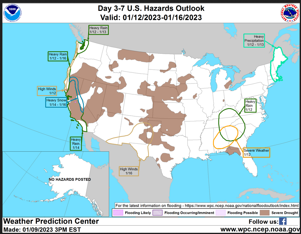
HAZARDS OUTLOOKS
Click here for the latest complete Day 3 -7 Hazards forecast which updates only on weekdays. Once a week probably Monday or Tuesday I will update the images. I provided the link for readers to get daily updates on weekdays. Use your own judgment to decide if you need to update these images. I update almost all the images Friday Night for the weekend edition of this Weather Report. So normally readers do not need to update these images but if the weather is changing quickly you may want to.
Month to Date Information
Temperature month to date can be found at https://hprcc.unl.edu/products/maps/acis/MonthTDeptUS.png
Precipitation month to date can be found at https://hprcc.unl.edu/products/maps/acis /MonthPNormUS.png
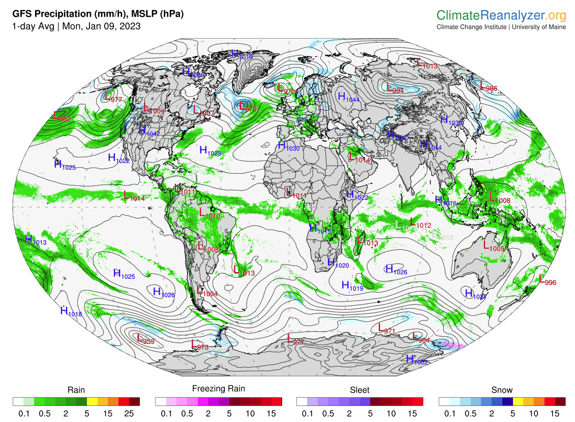
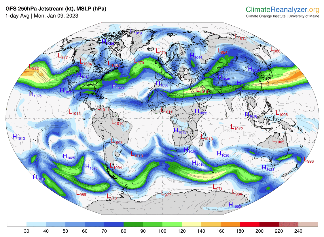
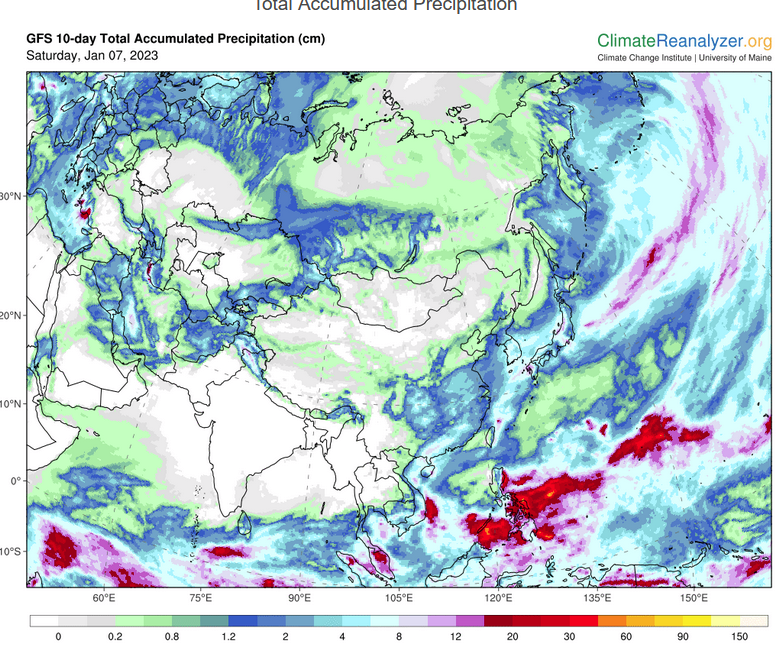
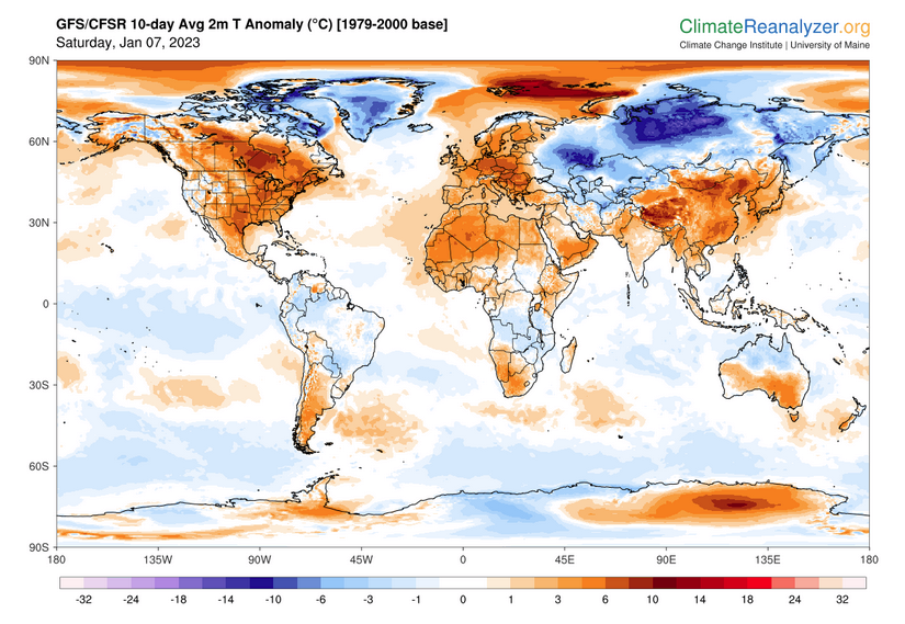
World Forecast
Below are the current precipitation forecast and the 10-Day forecasts for temperature and precipitation. Updates and additional information can be obtained HER E
Much of this information is provided by the University of Maine. They draw upon many different sources.
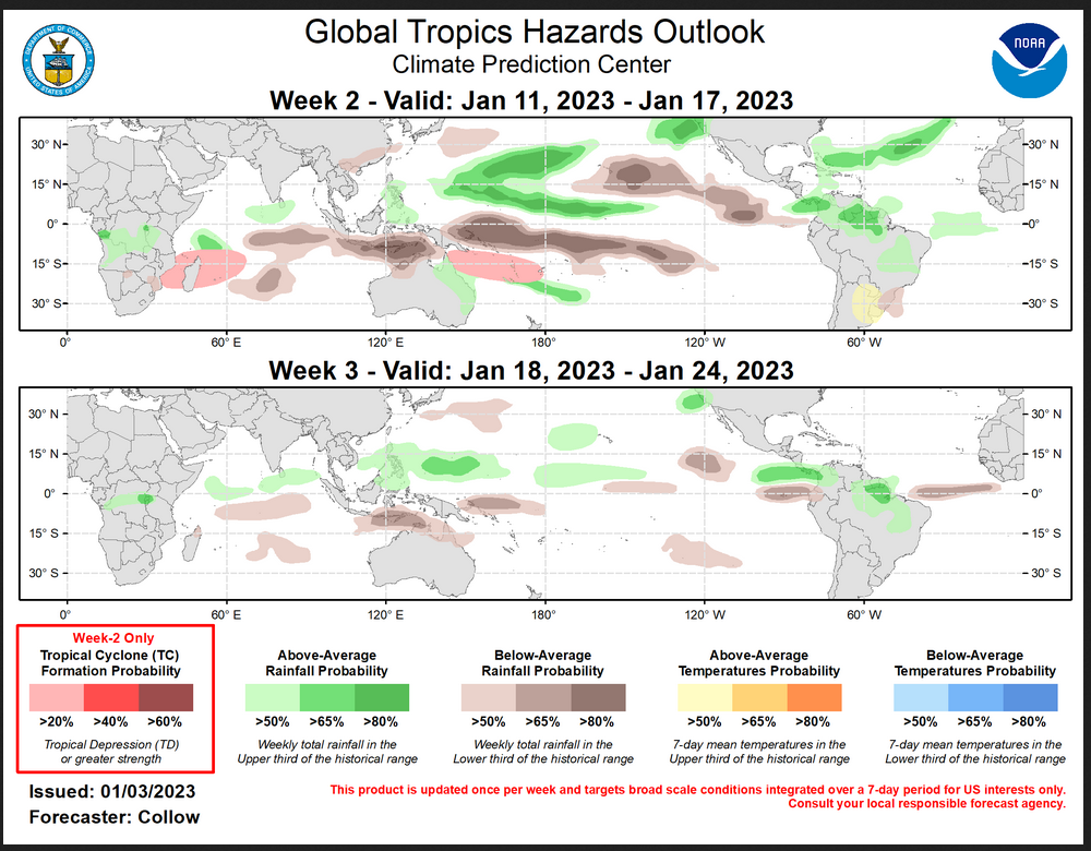
Worldwide Tropical Forecast (This is a NOAA Product)
This graphic updates on Tuesdays) If it has not been updated, you can get the update by clicking here Readers will only have to do that if they are reading this article much later than the date of it being published.
–
| I hope you found this article interesting and useful. |