We have discussed this before but the fact that there is a possibility of a third La Nina Winter is a good reason to discuss it again. I would say that is is not real likely. But if it happens, it would be very serious. So that is why it is worth discussing. We have not previously discussed how Global Warming makes any drought more dangerous but that should be obvious. We know that the negative phase of the Pacific Decadal Oscillation (PDO) results in a higher ratio of La Nina to El Nino Events. But we have not discussed how Global Warming might impact the PDO. So we are not addressing the broader question of whether or not Global Warming is increasing the chance of a third year of La Nina but simply looking at the evidence that a third year is a possibility. It seems that NOAA may be more concerned about the possibility than some other weather forecasting agencies in other part of the world, but we will attempt to show that their concern is not unreasonable.

Introduction
This is very long with a lot of graphics and I do not expect readers to follow all of the argument. The reason for the length is the importance of the topic and I want to share as much as I knew about the topic.
If we have a third winter of La Nina, it is likely to be a disaster for the U.S. West. It is IMO unlikely but those who do not prepare for it are being very foolish.
Why we think a Three-peat is possible
Here is an interesting graphic. It shows the eight most recent La Nina double-dip events and for seven of them how the subsequent year evolved.

The black line is the current situation. As you can see, there are various outcomes when you have had two years of La Nina. The following year can be another La Nina, or Neutral or an El Nino. Logically, the subsequent year is more likely to be Neutral or El Nino but take a close look at this image.
Apparently we had three La Ninas in a row in 1998, 1999 and 2000. 1998, 1999, 2000 followed the MegaNino of 1997 and to me began the change of phase of the Pacific Decadal Oscillation.(PDO).
This graph may help with this. It is kind of long so I am just providing the link. https://origin.cpc.ncep.noaa.gov/products/analysis_monitoring/ensostuff/ONI_v5.php
1998,1999, 2000 proves out. I think the other triple dip was 1973, 1974 and 1975 and that was before I moved to New Mexico. But I was in Salt Lake City, Utah during most of that period of time. They are a bit farther north so they would perhaps have been impacted less. I recall having a job interview in SLC I think in April of 1974 and arriving to three feet of snow on the ground. So not all La Ninas are dry or dry all the time.
Why it is Important.
We know this Spring will be a La Nina event and we know that Summer is not much affected by ENSO. So the question is mostly about Fall of this year and the 2022/2023 Winter.
A triple dip La Nina may not be very strong. If it tended to be dry it would be very difficult for New Mexico and Arizona.
Why do we think it is possible that we will have a third year of La Nina?
First we take a look at the NOAA proprietary Nino 3.4 forecasting model.

This may or may not automatically update. If it does not you can obtain an updated version by clicking here. https://www.cpc.ncep.noaa.gov/products/people/wwang/cfsv2fcst/images3/nino34SeaadjPDFSPRDC.gif
This model does not show the La Nina ending this year but extending into Fall.
What about the CPC/IRI ENSO Probability Forecast?

The problem here is that the probabilities of La Nina versus ENSO Neutral are about equal through OND 2022
But there is a later version

It looks a lot better. Normally NOAA has more faith in the first forecast which is prepared by meteorologists than the second forecast shown above which is based on computer modeling forecasts. Still, it is not clear what the result will be in NDJ 2022/2023. It is too close to call.
And there there is what is called the “plume” of forecasts which is nothing more than the forecasts from a number of different meteorological agencies using their computer models.
Both the the graphic above and the plume were not available to NOAA when it made its Seasonal Forecast on March 17 or at least we do not think they were.

This looks well behaved with most models moving into ENSO Neutral by the end of the year. But not all of them.
Here is a related analysis put out by the Australian Bureau of Meteorology (BOM).
First I am showing the BOM proprietary model

It shows a return to ENSO Neutral
Then on the left is a summary of model results predicting the state of ENSO first for March and to the right for August.


For March, their choice of models shows La Nina or close to La NIna. For August only the NOAA model shows La Nina. Remember that is the NOAA proprietary model and NOAA does not rely on it a lot. But the CPC/IRI probability analysis showed equal chances for ENSO Neutral and La Nina.
What does JAMSTEC think?

It certainly seems to be behaving normally. In fact it is heading towards El Nino. But this forecast was made on March 1, 2022 or at least it was made based on model runs that used March 1, 2022 initial conditions.
A look at Temperature Anomalies along the Equator in the Pacific Ocean

You can ignore the bottom graphic. The top graphic shows warm water east of where NINO 3.4 is measured and also far to the west of where NINO 3.4 is measured. The problem is that usually a La Nina is attacked from the West and that does not look likely to happen. Will the warmer water to the east move west and also surface since it is the surface that determines what state of ENSO we are in. I think the answer to that is “maybe”.
The above graphic May or may not automatically update but you can obtain updates by clicking here https://www.cpc.ncep.noaa.gov/products/analysis_monitoring/ocean/weeklyenso_clim_81-10/wkteq_xz.gif
How has the situation changed over time
Exactly where is ENSO Measured?

In the U.S. the ENSO Index is usually what is called the Nino 3.4 which is a combination of the eastern third of Nino 4 shown in yellow and the western half of Nino 3 shown in red. It can be a little confusing looking at the above diagram but it is the area from 170W Longitude to 120W Longitude extending 5 degrees north and south of the Equator.
Here is one way to look at it.

This shows about six weeks of history. Notice the warm water coming in from West has been rejected. But the cool anomaly has moved west and there is a pocket of warm water just to the east. By warm or cool we mean anomalies that is difference from normal for that longitude and depth. Yes, NOAA has that information. And it is adjusted every five years.
Here is another way to look at things.

For the top graphic of the two-graphic exhibit, about three graphics earlier, this integrates the temperature anomalies for the area 180W to 100W over time and you can see that this netted out to a small warm anomaly in February but it has gone back to a net negative position in March.
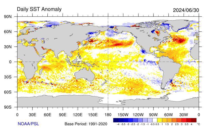
But we are not just interested in the Equator so this is useful also
It shows the daily Sea Surface Temperature (SST) Anomaly.

The blue is the La Nina. It has moved to the west. It is stronger south of the Equator than north of the Equator. This might or may not update and if it does not you can obtain updates by clicking here. https://psl.noaa.gov/map/images/sst/sst.daily.anom.gif
Additional Information to Consider

We recently discussed the downwelling Oceanic Kelvin Wave that brought some warm water over to the east and now we see the upwelling phasee of that Kevin Wave.

This exhibit is a little tricky in a couple of different ways. First of all NOAA does not do a good job of defining what is meant by Westerly and Easterly Anomalies. It took me a few years to figure it out and I may not have it correct. What I concluded was that that they were working with Westerly winds being the norm so that positive numbers means more westerly and negative numbers mean less westerly or actually easterly. This is a Hovmoeller diagram so the bottom shows the most recent readings and earlier readings are shown farther to the top of the graphic. Let’s assume that I have that correct.
I have no idea why they have blocked off a certain area in blue dashed lines. I am sure the have a good reason. I would think that it might be the Kelvin Wave Generating Area but it seems too far east for that but maybe not.
The red areas are westerly winds probably generated by a MJO Event. You probably can correlate the series of westerly blips to the most recent Oceanic Kelvin Wave. What is most import right now is we have prevailing easterlies so we are not likely to have another Oceanic Kelvin Wave soon.
What are the Typical Impacts of La Nina

Above is what we have now or at least it is typically what we would get with a La Nina. That does not mean that winter weather follows this pattern every single day. It just means that this is the typical pattern with a typical La Nina. Notice it would be likely to continue the drought along the Southern Tier of the U.S.
This compares to the below image.

The pattern is very different. One major difference is the location of the Jet Stream. For El Nino it is much farther south. This generally means that more of CONUS is cooler and storms from the Pacific tend to enter CONUS from the west but farther south. With La Nina which is our current pattern, the Jet Stream is farther north but it has more of a wavy pattern. Thus tracking the low-pressure systems as they cross CONUS may be more challenging and there can be more cold air intrusions perhaps.
ENSO is not the only factor that impacts our weather and no two El Ninos or La Ninas are identical. But it is a major factor so we pay a lot of attention to it.
ENSO Neutral is mid way between El Nino and La Nina
The ENSO Cycle
It is not a normal cycle in which the different phases are predictable. But I liken it to a battery. With La Nina, you have stronger than usual Easterlies that skim off warm surface water sending it west and building up and expanding the Indo-Pacific Warm Pool. Why this ends is not 100% clear but there are a number of factors that make it unlikely that the process can proceed in that direction indefinitely.
So in a typical seven year period there may be one or two La Nina Years and one or two El Nino years with the rest being ENSO Neutral. This spreads the wet and dry areas around the U.S. so that we do not have multiple years of drought or flooding.
Thus three dry years in a row in the same area is a big problem.
That is the concern.
Conclusions
A La Nina Three-peat or Triple-Dip would be disastrous for the U.S. West but it is unlikely. However, it can not be ruled out at this point in time.
References
This article was inspired in part by this post in the NOAA Climate.Gov ENSO Blog https://www.climate.gov/news-features/blogs/enso/march-2022-la-ni%C3%B1a-update-three-bean-salad
Climate Prediction Center ENSO Page https://www.cpc.ncep.noaa.gov/products/precip/CWlink/MJO/enso.shtml#discussion