Our Report on the JAMSTEC Three-Season Weather Forecast – October 21, 2023

The Japan Agency for Marine-Earth Science and Technology, or JAMSTEC, is a Japanese national research institute for marine-earth science and technology
From the JAMSTEC Discussion:
As predicted, the recent observation confirms further development of the El Niño. The SINTEX-F ensemble mean predicts that the El Niño will reach its peak in the boreal winter and persist at least until the next boreal spring. However, there is a large uncertainty in the predicted amplitude.
Although it is a World forecast, it includes a forecast for North America since North America is part of the World. The JAMSTEC discussion does not address it but the maps show the U.S. being an area that has a lot of area that is not warmer than Climatology which I interpret as a fairly cold winter but surprisingly dry in the Southwest.
First, we take a look at the forecasted sea surface temperature anomalies (SSTA). JAMSTEC starts by forecasting the SSTA and Nino 3.4 Index on the first day of the month and from there it usually takes their models about two weeks to produce their seasonal forecast. I received it from JAMSTEC on October 20, 2023 which is when NOAA issued their Seasonal Update. The JAMSTEC model runs are based on conditions as of October 1, 2023. The NOAA Seasonal Outlook was based on conditions closer to the time when it is issued.
We do not have a three-season forecast from JAMSTEC this month. We have three forecasts but the first covers NDJ and the second covers DJF so they are just a month apart. This is because JAMSTEC prefers to work with the Meteorological Seasons so we have Winter and Spring and the first map which is one month of Autumn with two months of winter so they are very similar.
One might question their winter forecast for the Southwest but it is somewhat consistent with the below.
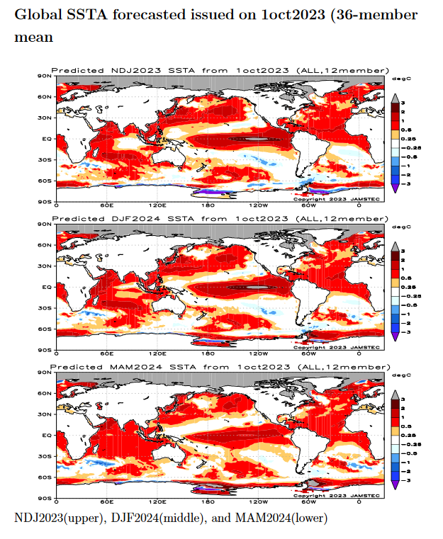
| This shows their forecast of sea surface temperature anomalies at three points in time. Red is warm and is associated with El Nino. You can see the El Nino tongue of warm water extending from Peru to the west in all three time periods. It seems to be stronger in the 1st and 2nd time periods which overlap a lot. The warmest water shifts was bit west in the third period exhibiting some Modoki characteristics.
JAMSTEC (and also NOAA) are showing very warm oceans. I have written about that before. It raises questions about the reliability of our current approach to thinking about the ENSO Cycle. This is covered in another article that can be accessed HERE. But JAMSTEC is showing a relatively normal ocean off the coast of much of the U.S. which probably explains their strange forecast. JAMSTEC uses the same definition of Normal (climatology as NOAA). They do a better job at characterizing La Ninas and El Ninos than NOAA. JAMSTEC provides me with a lot of other information that I do not include in my articles to keep them to a manageable size for readers. |