Tonight, Tomorrow, Next Day, Five Days, and Intermediate-Term Outlooks for the U.S. and a Six-Day Forecast for the World: posted August 5, 2023

Here is what we are paying attention to in the next 48 to 72 hours. The article also includes weather maps for longer-term outlooks and a five-day World weather outlook.

We start with the U.S. Information. You can update this section here but these are 48 to 72-hour forecasts so if I have not been able to update this area twice daily, what is shown is still valid and the images in the body of the article update automatically but sometimes they are a bit slow to update.

Short Range Forecast Discussion
NWS Weather Prediction Center College Park MD
Sat Aug 05 2023

Valid 12Z Sat Aug 05 2023 – 12Z Mon Aug 07 2023

…Dangerous heat will continue for the Desert Southwest, Southern Plains
and Lower Mississippi Valley but relief for some is coming beginning on
Sunday…

…Potential for severe thunderstorms and/or flash flooding from the
central/northern Plains into parts of the Midwest…


Tonight, Tomorrow, Next Day, Five Days, and Intermediate-Term Outlooks for the U.S. and a Six-Day Forecast for the World: posted August 3, 2023

Here is what we are paying attention to in the next 48 to 72 hours. The article also includes weather maps for longer-term outlooks and a five-day World weather outlook.

We start with the U.S. Information. You can update this section here but these are 48 to 72-hour forecasts so if I have not been able to update this area twice daily, what is shown is still valid and the images in the body of the article update automatically but sometimes they are a bit slow to update.

Short Range Forecast Discussion
NWS Weather Prediction Center College Park MD
Thu Aug 03 2023

Valid 12Z Thu Aug 03 2023 – 12Z Sat Aug 05 2023

…There is a Slight Risk of excessive rainfall over parts of the
Ohio/Tennessee/Middle Mississippi Valleys, Southeast and Southern
Appalachians, along with two areas over the Northern/Central Plains into
the Great Basin…

…There is an Enhanced Risk of severe thunderstorms over parts of the
Central High Plains…

…Excessive Heat Warnings and Advisories from parts of Central/Southern
Plains and the Middle/Lower Mississippi Valley/Central Gulf Coast…


Tonight, Tomorrow, Next Day, Five Days, and Intermediate-Term Outlooks for the U.S. and a Six-Day Forecast for the World: posted August 2, 2023

Here is what we are paying attention to in the next 48 to 72 hours. The article also includes weather maps for longer-term outlooks and a five-day World weather outlook.

We start with the U.S. Information. You can update this section here but these are 48 to 72-hour forecasts so if I have not been able to update this area twice daily, what is shown is still valid and the images in the body of the article update automatically but sometimes they are a bit slow to update.

Short Range Forecast Discussion
NWS Weather Prediction Center College Park MD
Wed Aug 02 2023

Valid 12Z Wed Aug 02 2023 - 12Z Fri Aug 04 2023

...There is a Moderate Risk of excessive rainfall over parts of the Middle
Mississippi Valley on Wednesday and a Slight Risk over parts of the
Ohio/Tennessee Valleys and Southern Appalachians, along with two areas
over the Northern/Central Plains on Thursday...

...There is a Slight Risk of severe thunderstorms over parts of the Middle
Mississippi Valley on Wednesday and the Central High Plains on Thursday...

...Excessive Heat Warnings and Advisories from parts of Central/Southern
Plains and the Lower Mississippi Valley/Central Gulf Coast...


NOAA Updates It’s August, 2023 Outlook on July 31, 2023- There Have Been Some but not Dramatic Changes from the Mid-Month Outlook

At the end of every month, NOAA updates its Outlook for the following month which in this case is August of 2023. We are reporting on that tonight.

There have been some changes in the Outlook for August but they are not dramatic and these are addressed in the NOAA Discussion so it is well worth reading.  We provided the prior Mid-Month Outlook for August for comparison. It is easy to see the changes by comparing the Mid-Month and Updated Maps.

The article includes the Drought Outlook for August. NOAA also adjusted the previously issued Seasonal Drought Outlook to reflect the changes in the August Outlook. We have also included the current fire incidents and a map showing the water-year-to-date precipitation. We also provide the Week 2/3 Tropical Outlook for the World.

The best way to understand the updated outlook for August is to view the maps and read the NOAA discussion. But here are some of the highlights:

  • El Niño conditions are present in observations of the equatorial Pacific atmospheric and ocean, and are likely to continue through the month of August and into later seasons.
  • The updated August temperature outlook favors above normal temperatures across Alaska with more likely above normal temperatures for southeastern Alaska,
  • Above normal temperatures continue to be favored for much of the West, as in the prior outlook. However, probabilities of above normal have decreased substantially across the Great Basin, and there are now equal chances (EC) of above, near or below normal temperatures for much of California,
  • Below normal temperatures are favored for a small area of the northern High Plains,
  • Probabilities of above normal temperatures are further enhanced from the Southern Plains into the Southeast,
  • Average below normal temperatures are slightly favored for parts of the Northeast for the month of August,
  • The updated August precipitation outlook favors below normal precipitation for southwestern areas of the Alaska Mainland eastward along the coast into southeast Alaska,
  • Above normal precipitation is favored in a swath from the northern Rockies across parts of the High Plains, the Central Plains, and Ohio Valley,
  • Above normal precipitation is likely for August, probabilities exceeding 50 percent, for a small area of the northern High Plains,
  • Above normal precipitation is favored for the East Coast from parts of the Carolinas to New England, with much above average sea surface temperatures offshore and the influx of moisture.
  • Below normal precipitation is favored from parts of the Southwest, the Rio Grande Valley, and the Gulf Coast, to the Florida Panhandle,
I am going to start with a graphic that shows the updated Outlook for August followed by a graphic that shows both the Updated Outlook for August and also the three-month outlook ASO 2023. So you get the full picture in two graphics.

Here is the updated Outlook for August 2023

For Comparison Purposes, Here is the Mid-Month Outlook for August.

There has been some change but not dramatic. Remember, it is the top set of maps that are the current outlook for August.

Combination of the Updated Outlook for August and the Three-Month Outlook

The top row is the Updated Outlook for the new month. There is a temperature map and a precipitation map. The second row is a three-month outlook that includes the new month. I think the outlook maps are self-explanatory. What is important to remember is that they show deviations from the current definition of normal which is the period 1991 through 2020.  So this is not a forecast of the absolute value of temperature or precipitation but the change from what is defined as normal or to use the technical term climatology.
Not much difference between August and the three-month period that includes August.  I am too tired to figure it out right now but there is some similarity between the one-month and three-month and the mid-month for August and the updated outlook for August. There is no reason for that but if I am not dreaming it there is some pattern there which I will look at again the next time I am coherent and have the time to do it.

ANALYSIS
Notice that for both temperature and precipitation, the one-month Outlook and three-month Outlook are not similar. This suggests that the Outlook for the combined second and third months if shown would be different than either the Outlook for the First (next) Month or the Three-Month Outlook. The formula for calculating the combined second and third-month outlook is:
For both temperature and precipitation, if you assume the colors in the maps are assigned correctly, it is a simple algebra equation to solve the month two/three anomaly probability for a given location = (3XThree-Month Probability – Month One Probability)/2*. So you can derive the month two/three outlook this way. You can do that calculation easily for where you live or for the entire map.

It is important to remember that the Outlook for next month was updated on the last day of the current month and the three-month Outlook was issued on the third Thursday. So the period of time between the Mid-Month and End of Month Update varies from month to month from 10 days to 16 days. So there sometimes is a substantial change in the Next Month’s Outlook from the Mid-Month prediction.  In such cases, we wonder if a change in the one-month outlook suggests that the three-month outlook would need to also be adjusted. This month I do not think that it is the case.

Tonight, Tomorrow, Next Day, Five Days, and Intermediate-Term Outlooks for the U.S. and a Six-Day Forecast for the World: posted August 1, 2023

Here is what we are paying attention to in the next 48 to 72 hours. The article also includes weather maps for longer-term outlooks and a five-day World weather outlook.

We start with the U.S. Information. You can update this section here but these are 48 to 72-hour forecasts so if I have not been able to update this area twice daily, what is shown is still valid and the images in the body of the article update automatically but sometimes they are a bit slow to update.

Short Range Forecast Discussion
NWS Weather Prediction Center College Park MD
Wed Aug 02 2023

Valid 12Z Wed Aug 02 2023 – 12Z Fri Aug 04 2023

…There is a Moderate Risk of excessive rainfall over parts of the Middle
Mississippi Valley on Wednesday and a Slight Risk over parts of the
Ohio/Tennessee Valleys and Southern Appalachians, along with two areas
over the Northern/Central Plains on Thursday…

…There is a Slight Risk of severe thunderstorms over parts of the Middle
Mississippi Valley on Wednesday and the Central High Plains on Thursday…

…Excessive Heat Warnings and Advisories from parts of Central/Southern
Plains and the Lower Mississippi Valley/Central Gulf Coast…


Tonight, Tomorrow, Next Day, Five Days, and Intermediate-Term Outlooks for the U.S. and a Six-Day Forecast for the World: posted July 31, 2023

Here is what we are paying attention to in the next 48 to 72 hours. The article also includes weather maps for longer-term outlooks and a five-day World weather outlook.

We start with the U.S. Information. You can update this section here but these are 48 to 72-hour forecasts so if I have not been able to update this area twice daily, what is shown is still valid and the images in the body of the article update automatically but sometimes they are a bit slow to update.

Short Range Forecast Discussion
NWS Weather Prediction Center College Park MD
Mon Jul 31 2023

Valid 12Z Mon Jul 31 2023 – 12Z Wed Aug 02 2023

…There is a Slight Risk of excessive rainfall over parts of the Central
High Plains…

…Excessive Heat Warnings and Advisories from parts of Central/Southern
Plains and the Lower Mississippi Valley/Central Gulf Coast…


Tonight, Tomorrow, Next Day, Five Days, and Intermediate-Term Outlooks for the U.S. and a Six-Day Forecast for the World: posted July 30, 2023

Here is what we are paying attention to in the next 48 to 72 hours. The article also includes weather maps for longer-term outlooks and a five-day
World weather outlook.

We start with the U.S. Information. You can update this section here but these are 48 to 72-hour forecasts so if I have not been able to update this area twice daily, what is shown is still valid and the images in the body of the article update automatically but sometimes they are a bit slow to update.

Short Range Forecast Discussion
NWS Weather Prediction Center College Park MD
400 PM EDT Sun Jul 30 2023

Valid 00Z Mon Jul 31 2023 – 00Z Wed Aug 02 2023

…Cool and fair weather will persist across the northeastern quadrant of
the country as triple-digit heat continues across the southern half of the
Plains to the eastern Gulf Coast…

…Strong to severe thunderstorms are possible over the northern High
Plains into tonight as scattered showers and thunderstorms stretch across
the north-central Plains toward the Midwest…

…Monsoonal rainfall will become more widespread across the Desert
Southwest and into the Four Corners region while dry conditions persist
over the Pacific Northwest..


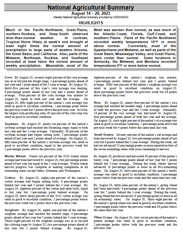
Crop Report July 29, 2023 – Crop Condition has Stabilized and May be Improving Somewhat -Where did the Cattle go?

This article is based primarily on the July 25, 2023, USDA Crop Bulletin which covers the July 17 to 23 period of time. The USDA report usually becomes available on Tuesdays and I was not able to publish my article which is based on that report until now. I have omitted a number of graphics but they are available in the full USDA Crop Bulletin and the link to that is at the end of the article.

It now seems more like an average crop but it has not gotten worse which is a relief and it seems that some of the crops are doing better.

There is a recent Executive Briefing focusing on Cattle and I have published it in its entirety but with a minimum of comments. I was curious as to why beef prices were so high at the food stores and I think the presentation explains at least one of the reasons for this.

The article includes a short international review of agricultural conditions.

We begin with the National Agriculture Summary.  The Tables below the summary have additional data. The boxes with my comments may be incomplete so for crops of interest check the data out yourself to be sure.


Tonight, Tomorrow, Next Day, Five Days, and Intermediate-Term Outlooks for the U.S. and a Six-Day Forecast for the World: posted July 29, 2023

Here is what we are paying attention to in the next 48 to 72 hours. The article also includes weather maps for longer-term outlooks and a five-day
World weather outlook.

We start with the U.S. Information. You can update this section here but these are 48 to 72-hour forecasts so if I have not been able to update this area twice daily, what is shown is still valid and the images in the body of the article update automatically but sometimes they are a bit slow to update.

Short Range Forecast Discussion
NWS Weather Prediction Center College Park MD
Sat Jul 29 2023

Valid 12Z Sat Jul 29 2023 – 12Z Mon Jul 31 2023

…There is a Slight Risk of excessive rainfall over parts of the
Northeast and Ohio Valley/Central Appalachians…

…There is a Slight Risk of severe thunderstorms over parts of Southern
New England to the Mid-Atlantic/Central Appalachians and a second area
over parts of the Northern/Central High Plains…

…Excessive Heat Warnings and Advisories from parts of Central/Southern
Plains eastward to the Middle/Lower Mississippi Valley and the western
Ohio/Tennessee Valleys and a second area from Southern New England to the
Mid-Atlantic and smaller areas over portions of California and Southwest…


Tonight, Tomorrow, Next Day, Five Days, and Intermediate-Term Outlooks for the U.S. and a Six-Day Forecast for the World: posted July 28, 2023

Here is what we are paying attention to in the next 48 to 72 hours. The article also includes weather maps for longer-term outlooks and a five-day
World weather outlook.

We start with the U.S. Information. You can update this section here but these are 48 to 72-hour forecasts so if I have not been able to update this area twice daily, what is shown is still valid and the images in the body of the article update automatically but sometimes they are a bit slow to update.

Short Range Forecast Discussion
NWS Weather Prediction Center College Park MD
400 PM EDT Fri Jul 28 2023

Valid 00Z Sat Jul 29 2023 – 00Z Mon Jul 31 2023

…Excessive Heat Advisories and Warnings are in effect for portions of
the East Coast, Central/Southern Plains, and over the Southwest…

…Temperature relief expected for the Northeast and Mid-Atlantic as a
cold front descends into the northern tier…

…An Enhanced Risk of Severe Thunderstorms is in effect for portions of
the lower Great Lakes on Friday evening…