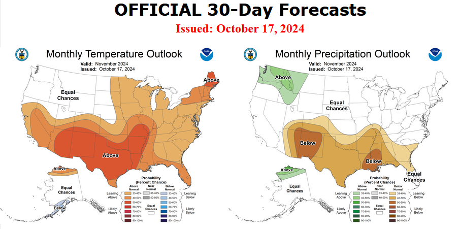
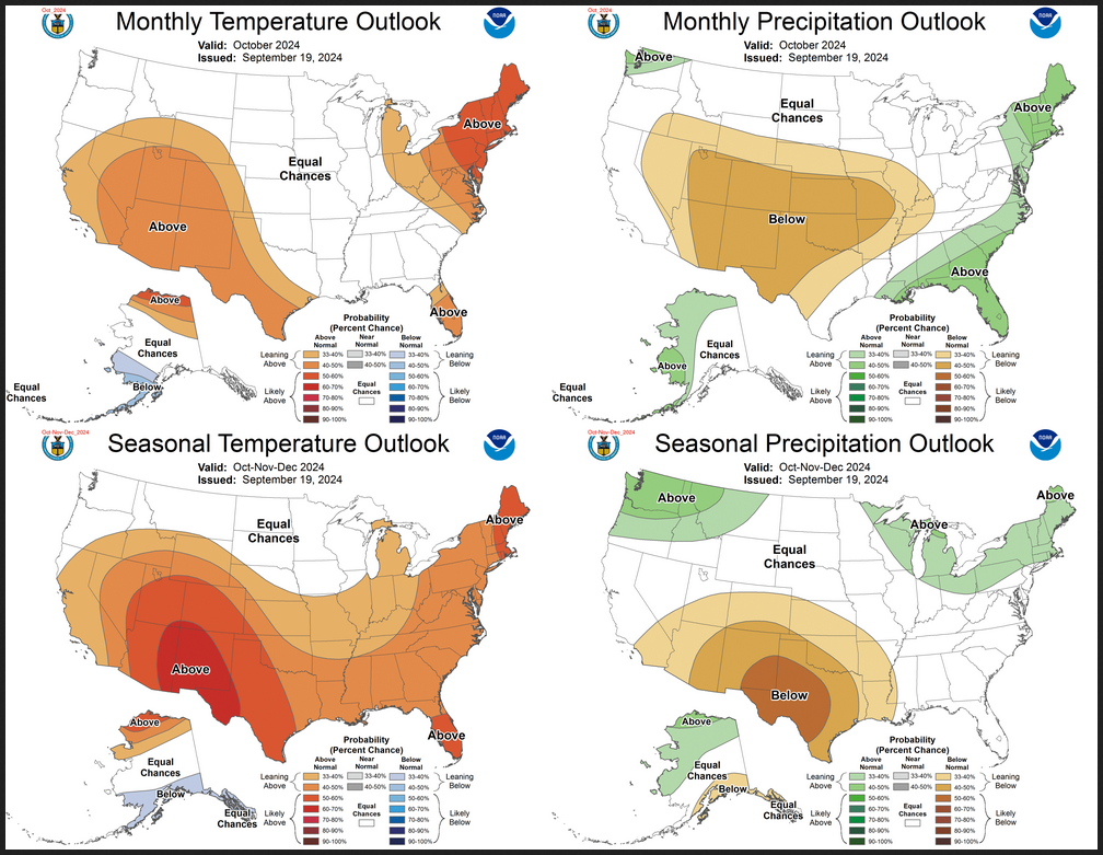
Weather Outlook for the U.S. for Today Through at Least 22 Days and a Six-Day Forecast for the World: posted December 25, 2024

This article focuses on what we are paying attention to in the next 48 to 72 hours. The article also includes weather maps for longer-term U.S. outlooks (up to four weeks) and a six-day World weather outlook which can be very useful for travelers.
First the NWS Short Range Forecast. The afternoon NWS text update can be found here after about 4 p.m. New York time but it is unlikely to have changed very much from the morning update. The images in this article automatically update.
Short Range Forecast Discussion
NWS Weather Prediction Center College Park MD
Wed Dec 25 2024
Valid 12Z Wed Dec 25 2024 – 12Z Fri Dec 27 2024…Continued rounds of heavy rain and mountain snow for the Pacific
Northwest……Heavy rain and strong thunderstorms return for eastern Texas into
Louisiana on Thursday……Relatively mild conditions across the majority of the country through
Thursday…The very active storm track across the eastern Pacific and into the
Pacific Northwest will continue to make weather headlines through
Thursday. After a brief break in the action, steady rainfall reaches the
Washington and Oregon coasts by midday Christmas, and then reaches
northern California by evening. Periods of heavy rainfall are likely
Wednesday night as the atmospheric river intersects the coastal terrain,
with perhaps a few thunderstorms. This round will likely result in
widespread 1 to 2 inch rainfall totals, and potentially more on the west
facing slopes, and there may be some instances of flooding where rainfall
rates are highest. Once this first system moves inland, there will be a
short-lived break Thursday afternoon before the next round arrives
Thursday night for many of the same areas, bringing an additional 1-2
inches of rain by Friday morning. Strong winds are also expected near the
coast and the coastal waters given a strong low level jet with these storm
systems. Snow levels are likely to be lower with the second round, with
the Cascades getting hammered with heavy snow on the order of 1-3 feet,
and lighter snows heading south into northern California. The higher
terrain of the northern Intermountain West and the Northern Rockies will
also get noteworthy snowfall, particularly across eastern Oregon and into
Idaho.Unsettled weather conditions are also expected for portions of the
south-central U.S. with a loitering surface low over Texas and a
meandering stationary front over eastern Texas and into Louisiana. There
will likely be a decrease in the shower and thunderstorm coverage on
Christmas Day, but an amplifying upper trough will develop a new surface
low and moisture plume from the western Gulf, heralding the development of
scattered to widespread showers and thunderstorms. Both wind shear and
instability parameters appear to become increasingly favorable for some
severe weather on Thursday, and therefore the Storm Prediction Center has
portions of the ArkLaTex region in a Slight Risk for severe storms. Heavy
rainfall could also be an issue where these storms train over the same
areas, and there is a Slight Risk of flash flooding from eastern Texas to
central Arkansas.Elsewhere across the country, mainly dry conditions are forecast across
the Desert Southwest, Northern Plains, and most of the East Coast states
with the exception of some showers near the Florida East Coast. Foggy
conditions are likely across portions of the Midwest and the Central
Plains both Christmas morning and Thursday morning with warm air advection
over cold ground. In terms of temperatures, forecast highs on Christmas
Day and Thursday generally range from the 30s and 40s for the northern
Rockies/Plains eastward to the Great Lakes and New England/Mid-Atlantic;
the 40s and 50s for the Pacific Northwest and northern California eastward
across much of the Intermountain West, central Rockies/Plains, and
extending eastward to the Ohio Valley; the 50s and 60s for the Mid-South
and the Southeast U.S. states; and the 60s and 70s for southern
California, the Desert Southwest, Texas, and Florida.
To get your local forecast plus active alerts and warnings click HERE and enter your city, state or zip code.