Today Through the Fourth Friday (22 to 28 days) Weather Outlook for the U.S. and a Six-Day Forecast for the World: posted February 14, 2024

It is difficult to find a more comprehensive Weather Outlook anywhere else with the ability to get a local 10-day Forecast also.

This article focuses on what we are paying attention to in the next 48 to 72 hours. The article also includes weather maps for longer-term U.S. outlooks and a six-day World weather outlook which can be very useful for travelers.

First the highlights from the NWS.

Short Range Forecast Discussion
NWS Weather Prediction Center College Park MD
Wed Feb 14 2024
Valid 12Z Wed Feb 14 2024 – 12Z Fri Feb 16 2024

…Quick-hitting wave of low pressure will bring a round of heavy,
accumulating snowfall across the Northern Plains, Upper Midwest, and the
Great Lakes today and Thursday…

…Next Pacific storm system will bring locally heavy rain along the West
Coast and heavy high elevation snowfall into the Intermountain West over
the next couple of days…

Above is a 72 hour animation of the forecast.

Then, looking at the world and of course, the U.S. shows here also. Today we are looking at precipitation.

Please click on “Read More” below to access the full report issued today.

Today Through the Fourth Friday (22 to 28 days) Weather Outlook for the U.S. and a Six-Day Forecast for the World: posted February 13, 2024

It is difficult to find a more comprehensive Weather Outlook anywhere else with the ability to get a local 10-day Forecast also.

This article focuses on what we are paying attention to in the next 48 to 72 hours. The article also includes weather maps for longer-term U.S. outlooks and a six-day World weather outlook which can be very useful for travelers.

First the highlights from the NWS.

Short Range Forecast Discussion
NWS Weather Prediction Center College Park MD
Tue Feb 13 2024
Valid 12Z Tue Feb 13 2024 – 12Z Thu Feb 15 2024

…Strong nor’easter to impact portions of the northern Mid-Atlantic and
southern New England today with areas of heavy snow, strong winds, and
coastal flooding…

…New storm system to arrive across the Northwest over the next couple of
days which will bring locally heavy rain and mountain snowfall…

Above is a 72 hour animation of the forecast.

Then, looking at the world and of course, the U.S. shows here also. Today we are looking at precipitation.

Please click on “Read More” below to access the full report issued today.

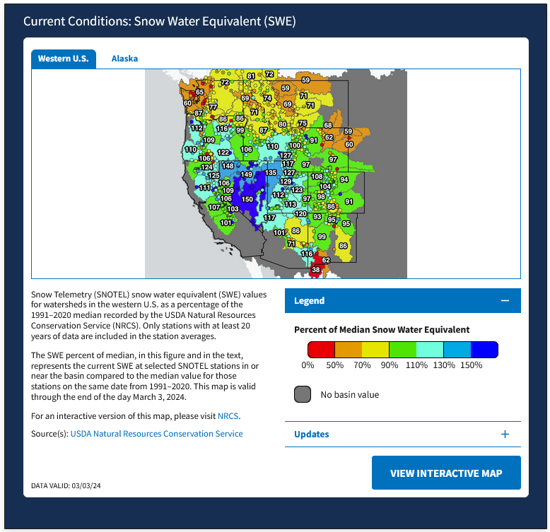
Snow Drought Current Conditions and Impacts in the West – El Nino Pattern – February 12, 2024

I receive this information once a month but it is really available weekly. But I get a nice report once a month so I send much of that out. The full report can be accessed HERE.

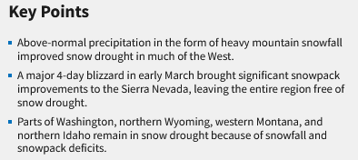
Here are the Highlights

 But there has just been a big snow event. So in the body of this article, I include much of the rest of the information provided to me by NIDIS but I also update one of the maps to February 10 conditions and include an end of January reservoir storage graphic also.   Some readers will have to click on “Read More” to access the rest of the article and others will not. It just depends on when and how you accessed this article.

Today Through the Fourth Friday (22 to 28 days) Weather Outlook for the U.S. and a Six-Day Forecast for the World: posted February 12, 2024

It is difficult to find a more comprehensive Weather Outlook anywhere else with the ability to get a local 10-day Forecast also.

This article focuses on what we are paying attention to in the next 48 to 72 hours. The article also includes weather maps for longer-term U.S. outlooks and a six-day World weather outlook which can be very useful for travelers.

First the highlights from the NWS.

Short Range Forecast Discussion
NWS Weather Prediction Center College Park MD
Mon Feb 12 2024
Valid 12Z Mon Feb 12 2024 – 12Z Wed Feb 14 2024

…A significant winter storm crossing the Mid-South today will transition
to a strong nor’easter for the Mid-Atlantic and New England by Tuesday…

…Areas of severe thunderstorms, heavy rainfall, and flash flooding will
be possible across portions of the Southeast today…

…New storm system to arrive across the Northwest by the middle of the
week with areas of locally heavy rain and mountain snowfall…

Looking out a bit farther and focusing on the more series events:

Above is a 72 hour animation of the forecast.

Then, looking at the world and of course, the U.S. shows here also. Today we are looking at precipitation.

Please click on “Read More” below to access the full report issued today.

Today Through the Fourth Friday (22 to 28 days) Weather Outlook for the U.S. and a Six-Day Forecast for the World: posted February 11, 2024

It is difficult to find a more comprehensive Weather Outlook anywhere else with the ability to get a local 10-day Forecast also.

This article focuses on what we are paying attention to in the next 48 to 72 hours. The article also includes weather maps for longer-term U.S. outlooks and a six-day World weather outlook which can be very useful for travelers.

First the highlights from the NWS.

Short Range Forecast Discussion
NWS Weather Prediction Center College Park MD
Sun Feb 11 2024
Valid 12Z Sun Feb 11 2024 – 12Z Tue Feb 13 2024

…A significant winter storm will continue impacting the Southern Rockies
and High Plains today before turning northeast and aiming for the Northern
Mid-Atlantic, New York, and New England early this week…

…Areas of severe thunderstorms and heavy rainfall will impact the Gulf
Coast states and Southeast for the remainder of the weekend and through
Monday…

…Above normal temperatures to generally persist into early next week for
much of the northern and eastern U.S., with below normal temperatures
across the South…

Looking out a bit farther and focusing on the more series events:

Above is a 72 hour animation of the forecast.

Then, looking at the world and of course, the U.S. shows here also. Today we are looking at precipitation.

Please click on “Read More” below to access the full report issued today.

Weather is Not Climate February 10, 2024

What is the difference between weather and climate?  It is quite complicated and quite frankly arbitrary and I personally do not like the NOAA definition of climate but this blog post sheds a little light on the subject.

It was posted in late January and it contains three short YouTubes you can watch that show how averaging turns weather into climate. It is not as precise as I would like but it at least starts the conversation. The post was written by Michelle L’Heureux

As many of the ENSO Bloggers do from time to time they intertwine the science with personal experience which may help in understanding the concept.

The official NOAA definition of Climate is the average over the last three completed decades so currently that is 1991 -2020. I do not like that definition because it does not reflect the influence of long cycles such as the AMO and PDO but I can not think of a better definition.

You can read the Blog Post with the comments HERE   But I have reproduced most of the post in this article with some of my comments so click “Read More” to read my article.

Today Through the Fourth Friday (22 to 28 days) Weather Outlook for the U.S. and a Six-Day Forecast for the World: posted February 10, 2024

It is difficult to find a more comprehensive Weather Outlook anywhere else with the ability to get a local 10-day Forecast also.

This article focuses on what we are paying attention to in the next 48 to 72 hours. The article also includes weather maps for longer-term U.S. outlooks and a six-day World weather outlook which can be very useful for travelers.

First the highlights from the NWS.

Short Range Forecast Discussion
NWS Weather Prediction Center College Park MD
Sat Feb 10 2024
Valid 12Z Sat Feb 10 2024 – 12Z Mon Feb 12 2024

…Winter storm to impact the central and southern Rockies and adjacent
High Plains going through the weekend…

…Areas of severe thunderstorms, heavy rainfall, and flash flooding will
be possible through Sunday from central and eastern Texas into the
Mid-South…

…Potentially record-setting warmth expected today across portions of the
Ohio Valley, Mid-Atlantic, and Northeast…

Looking out a bit farther and focusing on the more series events:

Above is a 72 hour animation of the forecast.

Then, looking at the world and of course, the U.S. shows here also. Today we are looking at precipitation.

Please click on “Read More” below to access the full report issued today.

NOAA Updates its ENSO Alert on February 8, 2024 – The El Nino Advisory Continues. The La Nina Watch Begins – Timing of the Transition is Uncertain

On the second Thursday of every month, NOAA (really their Climate Prediction Center CPC) issues its analysis of the status of ENSO. This includes determining the Alert System Status.  NOAA again describes their conclusion as “ENSO Alert System Status: El Nino Advisory La Nino Watch”

The timing of the transition is not very clear which will impact the reliability of the Seasonal Outlook to be issued next Thursday.

We have included an interesting animation from and a link to an ENSO Blog article by Tom Liberto


CLIMATE PREDICTION CENTER ENSO DISCUSSION

The second paragraph is what is important:

“The most recent IRI plume indicates a transition to ENSO-neutral during spring 2024, with La Niña potentially developing during summer 2024.  Even though forecasts made through the spring season tend to be less reliable, there is a historical tendency for La Niña to follow strong El Niño events.  The forecast team is in agreement with the latest model guidance, with some uncertainty around the timing of transitions to ENSO-neutral and, following that, La Niña.  Even as the current El Niño weakens, impacts on the United States could persist through April 2024 (see CPC seasonal outlooks for probabilities of temperature and precipitation).  In summary, a transition from El Niño to ENSO-neutral is likely by April-June 2024 (79% chance), with increasing odds of La Niña developing in June-August 2024 (55% chance).”

Below is the middle paragraph from the discussion last month.

“The most recent IRI plume indicates El Niño will gradually weaken and then transition to ENSO-neutral during spring 2024 .  Some state-of the-art dynamical climate models suggest a transition to ENSO-neutral as soon as March-May 2024.  The forecast team, however, delays this timing and strongly favors a transition to ENSO-neutral in April-June 2024.  There are also increasing odds of La Niña in the seasons following a shift to ENSO-neutral.  It is typical for El Niño to peak in December/early January, but despite weakening, its impacts on the United States could last through April (see CPC seasonal outlooks for probabilities of temperature and precipitation).  In summary, El Niño is expected to continue for the next several seasons, with ENSO-neutral favored during April-June 2024 (73% chance).”

We now provide additional details.  The level of uncertainty with respect to how this El Nino will play out has increased a bit.

CPC Probability Distribution

Here are the new forecast probabilities. The probabilities are for three-month periods e.g. JFM stands for January/February/March.

Here is the current release of the probabilities:

This chart shows the forecasted progression of the evolution of ENSO from the current El Nino State to Neutral and by the summer to La Nina.  This kind of  bar chart is not very good at showing uncertainty.

Here is the forecast from last month.

The analysis this month and last month are different.  This month the probability of El Nino in MAM is much more than was expected last month.  That is important.

Today Through the Fourth Friday (22 to 28 days) Weather Outlook for the U.S. and a Six-Day Forecast for the World: posted February 9, 2024

It is difficult to find a more comprehensive Weather Outlook anywhere else with the ability to get a local 10-day Forecast also.

This article focuses on what we are paying attention to in the next 48 to 72 hours. The article also includes weather maps for longer-term U.S. outlooks and a six-day World weather outlook which can be very useful for travelers.

First the highlights from the NWS.

Short Range Forecast Discussion
NWS Weather Prediction Center College Park MD
Fri Feb 09 2024
Valid 12Z Fri Feb 09 2024 – 12Z Sun Feb 11 2024

…Unsettled weather continues for the West with locally heavy snowfall
expected for many of the local mountain ranges…

…Heavy rainfall will become a concern this weekend across areas of the
South, and there will be a threat for scattered areas of flash flooding…

…Above average temperatures for the eastern half of the nation through
Saturday, potentially record-breaking for some locations…

Looking out a bit farther and focusing on the more series events:

Above is a 72 hour animation of the forecast.

Then, looking at the world and of course, the U.S. shows here also. Today we are looking at precipitation.

Please click on “Read More” below to access the full report issued today.

Today Through the Fourth Friday (22 to 28 days) Weather Outlook for the U.S. and a Six-Day Forecast for the World: posted February 8, 2024

It is difficult to find a more comprehensive Weather Outlook anywhere else with the ability to get a local 10-day Forecast also.

This article focuses on what we are paying attention to in the next 48 to 72 hours. The article also includes weather maps for longer-term U.S. outlooks and a six-day World weather outlook which can be very useful for travelers.

First the highlights from the NWS.

Short Range Forecast Discussion
NWS Weather Prediction Center College Park MD
Thu Feb 08 2024
Valid 12Z Thu Feb 08 2024 – 12Z Sat Feb 10 2024

…Unsettled weather continues for the West with moderate to locally heavy
snowfall for many of the local mountain ranges…

…Wintry precipitation for the Northern Plains as shower/thunderstorm
chances increase for the Upper Midwest/Great Lakes Thursday, spreading
into the South Friday…

…Much above average temperatures to end the work week for most of the
central/eastern U.S., record warmth for some locations in the Great Lakes
and Mid-Atlantic…

Looking out a bit farther and focusing on the more series events:

Above is a 72 hour animation of the forecast.

Then, looking at the world and of course, the U.S. shows here also. Today we are looking at precipitation.

Please click on “Read More” below to access the full report issued today.