Today Through the Fourth Friday (22 to 28 days) Weather Outlook for the U.S. and a Six-Day Forecast for the World: posted March 3, 2024

It is difficult to find a more comprehensive Weather Outlook anywhere else with the ability to get a local 10-day Forecast also.

This article focuses on what we are paying attention to in the next 48 to 72 hours. The article also includes weather maps for longer-term U.S. outlooks and a six-day World weather outlook which can be very useful for travelers.

First the NWS Short Range Forecast. The afternoon NWS text update can be found here but it is unlikely to have changed very much. The images in this article automatically update.

Short Range Forecast Discussion
NWS Weather Prediction Center College Park MD
315 AM EST Sun Mar 03 2024

Valid 12Z Sun Mar 03 2024 – 12Z Tue Mar 05 2024

…Winter storm in the West producing powerful blizzard in the Sierra
Nevada begins to wane through the day Sunday; more snow expected to begin
Monday…

…Accumulating snowfall near the Canadian border across Montana and North
Dakota with a wintry mix from North Dakota to northern Minnesota…

…Another coastal storm is forecast to bring additional rain along the
Mid-Atlantic coast later on Monday...

…Much above average, Spring-like temperatures shifting from the
Plains/Midwest into the Northeast as Critical Fire Weather threat persists
in the central/southern High Plains…

Conditions in the West which has been impacted by widespread heavy
mountain snows, gusty winds, and a powerful blizzard in the Sierra should
begin to improve by Sunday morning as a moisture plume form the Pacific
weakens and the track of upper-level energies shifts northward. Winds will
wane in intensity, though some additional heavy snowfall is expected
through the day, particularly for the southern Cascades/Sierra, Wasatch,
and central Rockies. However, additional upper-level energies approaching
the West Coast Monday look to quickly bring back increasing precipitation
chances, including heavy snowfall, to the southern Cascades/northern
Sierra, and potentially inland across the northern Great Basin. Timing and
the location of the heaviest amounts remains a bit uncertain at this time,
but another influx of moisture from the Pacific is expected. Rain showers
and thunderstorms will persist along the coast of the Pacific Northwest
and northern California as a surface trough lingers along the coast. Some
locally heavy rainfall may occur Monday as the next system moves in,
particularly along southern Oregon into northern California.

Upper-level energy shifting eastward away from the West is helping to
organize/deepen a low pressure/frontal system over the Northern Plains
this morning, which is forecast to track eastward towards the
Midwest/Great Lakes Monday. Moderate to locally heavy snowfall is expected
to the northwest of the surface low track as colder air spreads in from
the north, most likely along the Canadian border from eastern Montana into
western North Dakota. A wintry mix is expected to the east from eastern
North Dakota into northern Minnesota. The deepening low will also bring
some gusty winds, with the potential for blowing snow where snowfall does
occur. To the south and east across the Mississippi Valley/Midwest,
initially limited moisture will keep precipitation chances very low
through Monday morning despite the approaching frontal system. However,
southerly return flow from the Gulf will eventually begin to lead to
increasing shower and thunderstorm chances through the day Monday and
particularly Monday night. Deeper moisture over portions of the central
Gulf Coast into the Lower Mississippi Valley may result in some locally
heavy rainfall and an isolated instance or two of flash flooding. Some
severe thunderstorms producing large hail and damaging winds may also be
possible.

Showers will end Sunday morning in New England as a coastal storm departs
the region east into the Atlantic. A quasi-stationary frontal boundary
lingering southwestward along the coast of the Southeast and into Florida
will keep storm chances up there through the day Sunday. Then, on Monday,
another coastal low is expected to organize along the Carolinas and begin
to move northward, bringing additional shower chances into the
Mid-Atlantic through Tuesday morning, especially for coastal areas.

Widespread much above average, Spring-like high temperatures will persist
across the central/eastern U.S. Sunday and Monday. The greatest anomalies
of 25-35 degrees will stretch from the Lower/Middle Missouri Valley
northeastward into the Upper Great Lakes Sunday, shifting into the Ohio
Valley, Lower Great Lakes, and interior Northeast on Monday. Numerous
daily record-tying/breaking highs are possible as temperatures reach into
the 70s for most locations. Conditions will also be rather warm across the
central and southern Plains Sunday, with temperatures well into the 70s
and even low to mid-80s. Unfortunately, persistent lee troughing leading
to gusty winds and dry conditions will continue the threat for wildfires
along the central and southern High Plains, with a Critical Risk of Fire
Weather (level 2/3) outlined by the Storm Prediction Center. Along the
East Coast, highs are forecast to range between the 40s and 50s for New
England, 50s and 60s for the Mid-Atlantic, and 70s to low 80s for the
Southeast/Florida. In the West, highs will remain cooler and below
average, ranging from the 30s and 40s in the Pacific Northwest and much of
the Interior West, 50s in northern/central California, 60s in southern
California, and 60s and 70s into the Desert Southwest. The coldest spot in
the country will be in the Northern Rockies/adjacent High Plains, where
highs will be in the teens and 20s following a couple cold front passages.

To get your local forecast plus active alerts and warnings click HERE and enter your city, state or zip code.

Above is a 72 hour animation of the forecast. Learn about wave patterns HERE.

Then, looking at the world and of course, the U.S. shows here also. Today we are looking at precipitation.

Please click on “Read More” below to access the full Daily Report issued today.

Today Through the Fourth Friday (22 to 28 days) Weather Outlook for the U.S. and a Six-Day Forecast for the World: posted March 2, 2024

It is difficult to find a more comprehensive Weather Outlook anywhere else with the ability to get a local 10-day Forecast also.

This article focuses on what we are paying attention to in the next 48 to 72 hours. The article also includes weather maps for longer-term U.S. outlooks and a six-day World weather outlook which can be very useful for travelers.

First the NWS Short Range Forecast. The afternoon NWS text update can be found here but it is unlikely to have changed very much. The images in this article automatically update.

Short Range Forecast Discussion
NWS Weather Prediction Center College Park MD
300 AM EST Sat Mar 02 2024

Valid 12Z Sat Mar 02 2024 – 12Z Mon Mar 04 2024

…Winter storm continues this weekend in the West with heavy mountain
snow, widespread damaging winds, and powerful blizzard conditions in the
Sierra Nevada…

…Wintry mix for portions of the Northern Plains with some moderate to
locally heavy snow possible…

…A coastal storm will bring widespread rain up the East Coast through
Saturday…

…Much above average, Spring-like temperatures expanding from the
Plains/Midwest into the Northeast this weekend with Critical Fire Weather
threat for the central/southern High Plains…

A significant winter storm continues to impact much of the West, including
dangerous, blizzard conditions for the Sierra Nevada as an amplifying
upper-level trough forces its way into the western U.S. A multi-day influx
of moisture from the Pacific interacting with colder air pushing southward
from Canada is bringing heavy higher elevation, mountain snows across most
of the ranges of the Pacific Northwest, northern/central California, the
Great Basin, and the northern/central Rockies. There is at least a
moderate chance (40-60% probability) of an additional 12″+ of snowfall
through the end of the weekend. In addition, widespread wind-related
advisories and warnings remain in effect across much of the greater
western U.S. as wind gusts reach upwards of 55 mph, with gusts as high as
75 mph for higher elevations, leading to the risk of downed trees and
power lines. The combination of snow and high winds is most intense in the
Sierra Nevada, where heavy snow rates exceeding 3″ per hour and winds
gusting over 100 mph are causing significant blowing, drifting snow and
whiteout conditions, making travel impossible through the area. The most
intense snow and wind should begin to wind down through the day Sunday.
High temperatures will be below average this weekend with the colder
airmass moving in, with highs in the teens and 20s for the Northern
Rockies; 30s and 40s for the Pacific Northwest, northern California, the
Great Basin, and central Rockies; 50s for central California; and 60s for
southern California. Temperatures will be warmer into the Southwest with
highs in the 70s.

Falling heights as the amplifying trough begins to shift eastward over the
northern High Plains will help to deepen/organize a low pressure/frontal
system during the day Saturday. This system is forecast to track east into
the Upper Midwest/Great Lakes Sunday. Limited moisture ahead of the system
will keep precipitation chances rather low. However, in the colder air to
the north/northwest of the system, enough moisture will be in place for a
wintry mix of freezing rain and snow across portions of the Northern
Plains. Some moderate to locally heavy snowfall will be possible along the
Canadian border. Winds will likely also be rather breezy, with the
potential for some blowing snow. To the east, a low pressure/frontal
system lifting up the East Coast will continue to spread showers through
the Mid-Atlantic and into New England Saturday bringing moderate to
locally heavy rainfall, particularly for coastal locations. Some showers
and thunderstorms will remain possible along the frontal boundary
lingering southwestward along the coastal Southeast, Florida, and the
central Gulf Coast. Rain chances will come down overnight Saturday and
into early Sunday as the system pushes eastward away from the coast.

Widespread well above average, Spring-like temperatures are forecast to
continue for much of the Plains and Midwest this weekend. The greatest
anomalies will be centered over portions of the central/northern Plains
and Upper Midwest Saturday, spreading into the Great Lakes and Middle
Mississippi/Ohio Valleys on Sunday, where forecast highs reaching well
into the 60s and 70s are upwards of 25-35 degrees above average. Some
highs may tie/break local daily records. Further south, highs will be into
the 70s and 80s for the Southern Plains. Unfortunately, the combination of
these warm temperatures along with gusty winds and dry conditions have
resulted in another Critical Risk of Fire Weather (level 2/3) from the
Storm Prediction Center for portions of the central and southern High
Plains. The warming trend will spread into the Northeast on Sunday
following the departure of the coastal low, with highs warming into the
40s and 50s in New England and the 50s and 60s in the Mid-Atlantic. While
not quite as anomalous, highs across the Southeast into the 60s and 70s
are still running above early March averages.

To get your local forecast plus active alerts and warnings click HERE and enter your city, state or zip code.

Above is a 72 hour animation of the forecast. Learn about wave patterns HERE.

Then, looking at the world and of course, the U.S. shows here also. Today we are looking at precipitation.

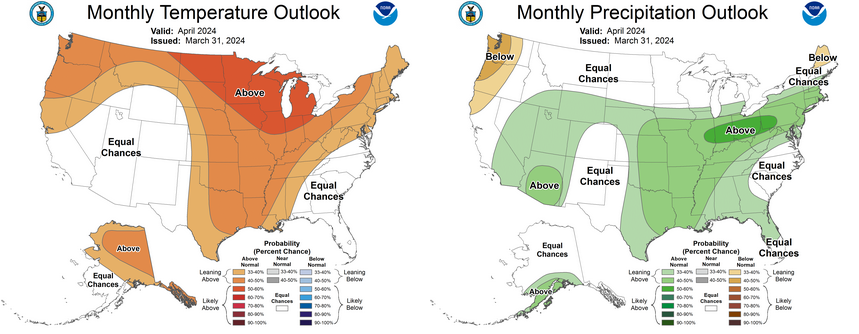
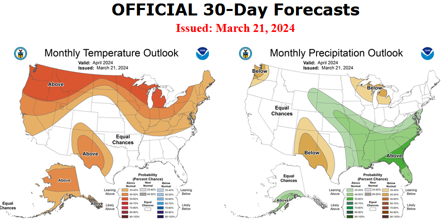
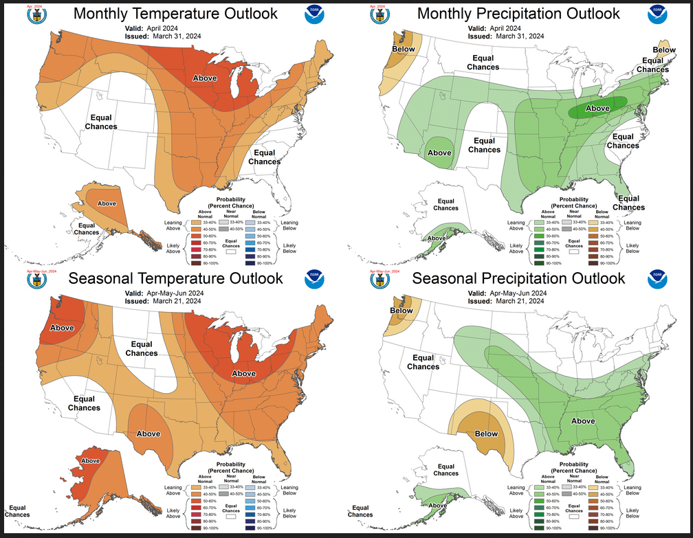
In case you missed it, this is the updated forecast for March and how it impacts the three-month Outlook.

Combination of the Updated Outlook for March and the Three-Month Outlook

The top row is the Updated Outlook for the new month. There is a temperature map and a precipitation map. The second row is a three-month outlook that includes the new month. I think the outlook maps are self-explanatory. What is important to remember is that they show deviations from the current definition of normal which is the period 1991 through 2020.  So this is not a forecast of the absolute value of temperature or precipitation but the change from what is defined as normal or to use the technical term climatology.

Please click on “Read More” below to access the full Daily Report issued today.

Northern Great Plains Response to Global Warming: Posted March 2, 2024

This is about the U.S. National Climate Assessment Program and in particular the Fifth U.S. National Climate Assessment which you can access HERE.

It is a long report and one part of the report is chapters on different regions of the U.S.   Last week I participated in a video Zoom session related to Chapter 25: the Northern Great Plains. So in this article, I will talk first about the National Climate Assessment (NCA) Program and then what I learned at the video session with the working group for the Northern Great Plains. After the discussion of the overall program, I will be using the slides presented at that session which are mostly from the National Climate Assessment report. I am using their slides because they presumable presented the slides that were of most interest to them and of course, there was only one hour for the session so that limits what can be presented.  If you do not like looking at slides without audio, you can access the Zoom session that was held HERE.

Introduction


This is important. Each Regional Chapter is organized around five topics and you will see them in this presentation.

Please click on “Read More” to access the discussion concerning the Northern Great Plains Region. It is presented in the form of responses to five key messages from the NCA5 Report.

NOAA Updates its March 2024 Weather Outlook – Not Much Different from the Mid-Month Outlook – March 1, 2024

At the end of every month, NOAA updates its Outlook for the following month which in this case is March of 2024. We are reporting on that tonight.

There have been some significant changes in the Outlook for March and these are addressed in the NOAA Discussion so it is well worth reading.  We provided the prior Mid-Month Outlook for March for comparison. It is easy to see the changes by comparing the Mid-Month and Updated Maps.

The article includes the Drought Outlook for March. NOAA also adjusted the previously issued Seasonal (MAM) Drought Outlook to reflect the changes in the March Drought Outlook. We have included a map showing the amount of water in the snowpack waiting to be released in the Spring. We also provide the Week 2/3 Tropical Outlook for the World.  We also include a very interesting CLIMAS Discussion.

The best way to understand the updated outlook for March is to view the maps and read the NOAA discussion. I have highlighted the key statements in the NOAA Discussion.

I am going to start with graphics that show the updated Outlook for March and the Mid-Month Outlook for March. This is followed by a graphic that shows both the Updated Outlook for March and the three-month outlook for MAM 2024. So you get the full picture in three graphics.

Here is the updated Outlook for March 2024.

For Comparison Purposes, Here is the earlier Mid-Month Outlook for March.

There have been some significant changes especially related to temperature. Remember, it is the top set of maps that are the current outlook for March.

Combination of the Updated Outlook for March and the Three-Month Outlook

The top row is the Updated Outlook for the new month. There is a temperature map and a precipitation map. The second row is a three-month outlook that includes the new month. I think the outlook maps are self-explanatory. What is important to remember is that they show deviations from the current definition of normal which is the period 1991 through 2020.  So this is not a forecast of the absolute value of temperature or precipitation but the change from what is defined as normal or to use the technical term climatology.
The three-month map was issued on February 15, 2024.  One expects some changes  14 days later. But the change to the precipitation map is not very dramatic.  This then gives us no reason to question the three-month MAM precipitation Outlook.
Some readers may need to click “Read More” to read the rest of the article.  Some will feel that they have enough information. But there is a lot more information in the rest of this article.

Today Through the Fourth Friday (22 to 28 days) Weather Outlook for the U.S. and a Six-Day Forecast for the World: posted March 1, 2024

It is difficult to find a more comprehensive Weather Outlook anywhere else with the ability to get a local 10-day Forecast also.

This article focuses on what we are paying attention to in the next 48 to 72 hours. The article also includes weather maps for longer-term U.S. outlooks and a six-day World weather outlook which can be very useful for travelers.

First the NWS Short Range Forecast. The afternoon NWS text update can be found here but it is unlikely to have changed very much. The images in this article automatically update.

Short Range Forecast Discussion
NWS Weather Prediction Center College Park MD
334 AM EST Fri Mar 01 2024

Valid 12Z Fri Mar 01 2024 – 12Z Sun Mar 03 2024

…Winter storm brings heavy higher elevation mountain snow, widespread
damaging winds, and cold temperatures to much of the West…

…Powerful blizzard in the Sierra Nevada through this weekend…

…Widespread showers and thunderstorms across portions of the Southeast
and Mid-Atlantic Friday…

…Much above average, Spring-like temperatures for the Plains and Midwest
once again heading into the weekend; Critical Fire Weather threat for the
central/southern High Plains Saturday...

A significant winter storm will impact much of the West heading into the
weekend, including dangerous, blizzard conditions for the Sierra Nevada.
An upper-level trough over the northeastern Pacific digging slowly
southward and inland over the West Coast will allow for a multi-day influx
of moisture from the Pacific/Atmospheric River as colder air spreads
southward. This will bring heavy snowfall to many of the higher elevation
mountain ranges across the Pacific Northwest, northern/central California,
the northern/central Rockies, and Great Basin, following a general
southward trend each day Friday and Saturday. Snow totals locally as much
as 12″+ are forecast through Sunday morning. In addition, widespread
damaging wind gusts of 55+ mph are forecast across much of the region,
with even stronger gusts of 75+ mph for higher elevations, leading to the
risk of downed trees and power lines. The most intense combination of snow
and wind will come together over the Sierra Nevada, where a powerful
blizzard is expected. Extreme snowfall totals of 5-12 feet (locally even
higher) are forecast through the weekend, with high snow rates and winds
leading to blowing/drifting snow and whiteout conditions, making travel
impossible. For lower elevations, the system will bring moderate to heavy
rainfall to coastal locations, with a mix of light to moderate rain/snow
for interior locations, though any accumulations should remain limited.
Some light snow may spread into portions of the northern High Plains
Saturday as the system continues east. The weather system will also usher
in cooler, below average temperatures, with highs generally in the 30s and
40s for the Pacific Northwest, northern California, northern Rockies, and
Great Basin, with 50s in central California and 60s into southern
California.

To the East, lift ahead of a shortwave moving eastward from the
Mississippi Valley towards the East Coast as well as Gulf moisture flowing
northward over a quasi-stationary boundary draped along the Gulf Coast
will bring widespread showers and thunderstorms across much of the
Southeast Friday. Some locally heavy downpours are possible, especially in
vicinity of the boundary along the central Gulf Coast and along the
Carolina coast. The boundary is forecast to lift northward along the East
Coast as the upper-level shortwave approaches, spreading rain chances into
the Mid-Atlantic overnight Friday and New England during the day Saturday,
with some locally heavy showers most likely once again for coastal
locations in vicinity of the boundary. Showers and storms will also linger
across portions of the coastal Southeast into north Florida and the
Florida Panhandle.

Much above average, Spring-like high temperatures are once again expected
across much of the Plains and Midwest heading into the Weekend. The
greatest anomalies are forecast for the northern Plains Friday and the
central Plains into the Upper Mississippi Valley Saturday where highs will
be upwards of 25-35 degrees above normal, reaching into the 60s and 70s.
Elsewhere, highs will be in the 40s and 50s in the Great Lakes. Highs
Saturday will warm into the 60s and 70s for the Middle/Lower Mississippi
Valley, with 80s returning to Texas. The warm temperatures as well as dry
conditions and some gustier winds along the central/southern High Plains
will bring the risk for wildfires this weekend, with the Storm Prediction
Center introducing a Critical Fire Weather outlook (level 2/3) for
Saturday. After a chilly day Friday in the Southeast, with highs generally
in the 40s and 50s, temperatures will quickly warm back up to average to
slightly above average levels Saturday, with highs in the 60s and low 70s.
Temperatures will also rebound for much of New England, warming from the
20s and 30s Friday into the 40s Saturday. Conditions will remain near to
above average in the Mid-Atlantic, with 40s and 50s expected.

To get your local forecast plus active alerts and warnings click HERE and enter your city, state or zip code.

Above is a 72 hour animation of the forecast. Learn about wave patterns HERE.

Then, looking at the world and of course, the U.S. shows here also. Today we are looking at precipitation.

Please click on “Read More” below to access the full report issued today.

Today Through the Fourth Friday (22 to 28 days) Weather Outlook for the U.S. and a Six-Day Forecast for the World: posted February 29, 2024

It is difficult to find a more comprehensive Weather Outlook anywhere else with the ability to get a local 10-day Forecast also.

This article focuses on what we are paying attention to in the next 48 to 72 hours. The article also includes weather maps for longer-term U.S. outlooks and a six-day World weather outlook which can be very useful for travelers.

First the NWS Short Range Forecast. The afternoon NWS text update can be found here but it is unlikely to have changed very much. The images in this article automatically update.

Short Range Forecast Discussion
NWS Weather Prediction Center College Park MD
Thu Feb 29 2024
Valid 12Z Thu Feb 29 2024 – 12Z Sat Mar 02 2024

…Heavy snow over parts of the Cascades, the Northern Intermountain
Region, Northern Rockies, Northern California, and Sierra Nevada
Mountains…

…Heavy lake-effect snow southeast of Lake Ontario and over the Upper
Great Lakes…

…Rain from the Gulf Coast to parts of northern Mid-Atlantic and shower
and thunderstorms along the Central Gulf Coast and Southeast…

A second winter storm will impact the West Coast on Thursday and Friday.
The storm will create heavy mountain snow that will affect many passes.
Multiple feet of snow are likely (over 80% chance) for higher elevations,
especially above 5000 feet, including many Cascade and Sierra Nevada
Mountain passes. Extremely heavy snow rates surpassing 3 inches per hour
are likely.

Furthermore, the storm will produce blizzard conditions in the Sierra
Nevada Mountains. In detail, strong winds will cause significant
blowing/drifting snow and whiteout conditions, making travel impossible in
the Sierra Nevada Mountains. There is a high chance (over 70%) of
substantial, long-lasting disruptions to daily life in the higher
elevations of the Sierra Nevada Mountains Friday-Saturday, where blizzard
conditions and 5+ feet of snow are expected.

Moreover, in addition to the snow, coastal rain will develop over parts of
the Pacific Northwest Thursday into Saturday. Coastal rain will develop
over parts of California Thursday morning, continuing into Saturday.

In addition, the widespread damaging wind will develop over the Western
U.S. Wind gusts of 55+ mph are forecasted across much of the West,
particularly across higher elevations and the Intermountain West, where
75+ mph gusts are possible. These winds would likely down trees and power
lines, resulting in power outages across affected areas.

Further, cold air will lower snow levels Friday into Saturday. As the
storm moves south, snow levels will lower into some Northern California
and Sierra Nevada Mountain foothill communities. Much colder air is
forecast for Saturday, with temperatures 10-20 degrees below normal.

Meanwhile, upper-level energy moving across the Great Lakes into the
Northeast will create lake-effect snow over the northeast portion of the
U.P. of Michigan, with the heaviest lake-effect snow southeast of Lake
Ontario on Thursday.

Additionally, upper-level energy moving over the Southern Rockies will
move eastward to the Mid-Atlantic by Saturday, producing rain and
higher-elevation snow over the Southern Rockies Thursday. Overnight
Thursday, showers and thunderstorms will develop over parts of the
Southern Plains, moving into the Lower Mississippi, Tennessee, and
Southern Ohio Valleys and parts of the Southeast by Friday. The showers
and thunderstorms will continue over parts of the Southeast through
Saturday. On Friday, rain will move into parts of the Mid-Atlantic and
Ohio Valley, moving into parts of the Northeast by Saturday. Also, on
Friday, scattered pockets of rain/freezing rain will develop over the
highest elevations of parts of the Central/Southern Appalachians.

To get your local forecast plus active alerts and warnings click HERE and enter your city, state or zip code.

Above is a 72 hour animation of the forecast. Learn about wave patterns HERE.

Then, looking at the world and of course, the U.S. shows here also. Today we are looking at precipitation.

Please click on “Read More” below to access the full report issued today.

Today Through the Fourth Friday (22 to 28 days) Weather Outlook for the U.S. and a Six-Day Forecast for the World: posted February 28, 2024

It is difficult to find a more comprehensive Weather Outlook anywhere else with the ability to get a local 10-day Forecast also.

This article focuses on what we are paying attention to in the next 48 to 72 hours. The article also includes weather maps for longer-term U.S. outlooks and a six-day World weather outlook which can be very useful for travelers.

First the NWS Short Range Forecast. The afternoon NWS text update can be found here but it is unlikely to have changed very much. The images in this article automatically update.

Short Range Forecast Discussion
NWS Weather Prediction Center College Park MD
Wed Feb 28 2024
Valid 12Z Wed Feb 28 2024 – 12Z Fri Mar 01 2024

…Heavy snow over parts of the Cascades, the Northern Intermountain
Region, Northern California, and Sierra Nevada Mountains…

…Light to moderate snow over the Great Lakes, Central Appalachians, and
Northeast…

…Temperatures will be 10 to 25 degrees above average over parts of the
Northeast and Mid-Atlantic…

A second winter storm will impact the West Coast on Wednesday and
Thursday. The second significant winter storm will primarily affect the
Northwest Wednesday and Thursday before significantly impacting the
Northern and Central California mountains Friday.

The storm will create heavy mountain snow that will affect many passes.
Multiple feet of snow are likely (over 80% chance) for higher elevations,
significantly above 5000 feet, including many Cascade and Sierra Nevada
Mountains passes. Extremely heavy snow rates surpassing 3 inches per hour
are possible in these mountain ranges.

Furthermore, the storm will produce blizzard conditions in the Sierra
Nevada Mountains. In detail, strong winds will cause significant blowing
and drifting snow, with whiteout conditions, making travel impossible in
the Sierra Nevada Mountains. There is a high chance (over 70%) of
substantial, long-lasting disruptions to daily life in the higher
elevations of the Sierra Nevada Mountains Friday, where blizzard
conditions and over 5 feet of snow are expected.

Moreover, in addition to the snow, coastal rain will develop over parts of
the Pacific Northwest Wednesday into Friday. Coastal rain will develop
over parts of Northern California overnight Wednesday, continuing into
Friday. The rain moves into Central California on Thursday, continuing
into Friday, and parts of Southern California by Friday morning.

Meanwhile, on Wednesday, a deep low over the Upper Great Lakes will move
northeastward into Eastern Canada by Wednesday evening. The associated
front will move off the East and Gulf Coast by Thursday morning. Ahead of
the front, southerly wind will bring warm temperatures of 10 to 25 degrees
above average over parts of the Northeast and Mid-Atlantic.

On Wednesday, the boundary will create showers and thunderstorms from the
Central Gulf Coast to the Northeast. In the wake of the front, moderate to
heavy snow will develop over the Great Lakes into the Northeast, with
light to moderate snow over the Central Appalachians on Wednesday. In
addition, on Thursday, lake-effect snow will develop downwind from the
Great Lakes, ending by Thursday night.

Elsewhere, upper-level energy moving into the Southwest and Southern
Rockies will produce scattered showers, thunderstorms, and
higher-elevation snow from Wednesday afternoon into Thursday. Overnight
Thursday, showers and thunderstorms will develop over parts of the
Southern Plains, moving into the Lower Mississippi, Tennessee, and
Southern Ohio Valleys and parts of the Southeast.

To get your local forecast plus active alerts and warnings click HERE and enter your city, state or zip code.

Above is a 72 hour animation of the forecast. Learn about wave patterns HERE.

Then, looking at the world and of course, the U.S. shows here also. Today we are looking at precipitation.

Please click on “Read More” below to access the full report issued today.

Ice Coverage Nearly Nonexistent Across the Great Lakes, as the Historical Peak Approaches: Posted on February 27, 2024

This article is mostly excerpted from a post by Haley Thiem on Climate.Gov which you can access HERE. I am calling it Global Warming News but it may just be natural variation. But I think we should look at this as possibly related to Global Warming.

 Author’s Note: This is a typical graphic used in meteorology and hydrology. The individual years are shown but may be difficult to see as they are faint but the average of the prior 50 years is clearly visible.  The blue line shows this year to date (February 15, 2024). It is clearly unusual. Is it unusual enough to conclude that it is outside of the range of Post Industrial Revolution Climate? I do not know. If this pattern shows up a few more times some will draw that conclusion. And for sure the winter is not yet over and I think it is snowing there right now.  Whether it is cold enough for ice to form I do not know. Since we are comparing the current to a 50 year average, I have categorized this as climate rather than weather but others may see it differently.

To read the remainder of the article most will need to click on “read more”

Today Through the Fourth Friday (22 to 28 days) Weather Outlook for the U.S. and a Six-Day Forecast for the World: posted February 27, 2024

It is difficult to find a more comprehensive Weather Outlook anywhere else with the ability to get a local 10-day Forecast also.

This article focuses on what we are paying attention to in the next 48 to 72 hours. The article also includes weather maps for longer-term U.S. outlooks and a six-day World weather outlook which can be very useful for travelers.

First the NWS Short Range Forecast. The afternoon NWS text update can be found here but it is unlikely to have changed very much. The images in this article automatically update.

Short Range Forecast Discussion
NWS Weather Prediction Center College Park MD
Tue Feb 27 2024
Valid 12Z Tue Feb 27 2024 – 12Z Thu Feb 29 2024

…Heavy snow returns over parts of the Cascades, the Northern
Intermountain Region, and Northern Rockies on Wednesday…

…Heavy snow over parts of the Upper Mississippi Valley and moderate to
heavy snow over the Cascades to Central Rockies on Tuesday…

…Light to moderate snow over the Great Lakes, Central Appalachians, and
Northeast on Wednesday…

…There is a Slight Risk of severe thunderstorms over parts of the Ohio
Valley/Great Lakes on Tuesday…

A strong winter storm and cold front will continue to progress through the
West, reaching the Central Rockies on Tuesday. Furthermore, the storm will
create near-blizzard conditions, resulting in dangerous travel. Snowfall
rates of 1-2 inches per hour will move into the Great Basin and Central
Rockies on Tuesday. These snow rates combined with winds gusting 50-65 mph
will produce near-blizzard conditions with significantly reduced
visibility and snow-covered roads leading to dangerous travel. Further,
significant snow accumulations will occur across the Colorado Rockies
southward into the San Juans and Sangre de Cristos; there is a high chance
(greater than 70%) of more than 8 inches of snow in the higher elevations.

In addition, widespread snow squalls are expected to develop along the
path of the cold front from Utah to Wyoming and Colorado on Tuesday. Where
snow squalls occur, intense snow rates will produce rapid drops in
visibility and icing on roadways, resulting in dangerous travel.

In addition, much colder air will move in behind the strong cold front.
Temperatures will fall into the teens and single digits Tuesday morning
throughout the Intermountain West.

Another powerful storm will move over the West, producing a significant
winter storm over the Pacific Northwest late Wednesday into Thursday, as
heavy snow returns to the Northern Cascades and Northern Intermountain
Region.

Meanwhile, on Tuesday, a front extending from the Upper Great Lakes to the
Central Rockies will create heavy snow over parts of the Upper Mississippi
Valley and moderate to heavy snow over the Upper Great Lakes. Ahead of the
front, southerly wind will bring warm temperatures of 15 to 30 degrees
above average to the Southern Plains to the Great Lakes. The warm and dry
conditions with gusty winds across the Southern Plains have resulted in an
Elevated Risk of Fire Weather (level 1/3) from the Storm Prediction Center
on Tuesday.

Additionally, moisture from the Western Gulf of Mexico will stream
northward over the Southern Plains, Middle/Lower Mississippi Valley, and
Ohio Valley. The moisture will aid in creating showers and severe
thunderstorms over parts of the Ohio Valley. Therefore, the SPC has issued
a Slight Risk (level 2/5) of severe thunderstorms over parts of the Ohio
Valley, Middle Mississippi Valley, and Great Lakes through Wednesday
morning. The hazards associated with these thunderstorms are frequent
lightning, severe thunderstorm wind gusts, hail, and a few tornadoes.
Further, there is an increased threat of hail two inches or greater over
parts of southwestern Michigan, most of Illinois and Indiana, plus
southeastern Missouri.

Moreover, as the robust front moves across the Great Lakes to the East
Coast, moderate to heavy snow will develop over the Great Lakes into the
Northeast, with light to moderate snow over the Central Appalachians on
Wednesday into Thursday morning. Ahead of the snow, showers and
thunderstorms will develop over parts of the Northeast. The boundary will
also create showers and thunderstorms over parts of the Eastern Ohio
Valley, Central Appalachians, into the Mid-Atlantic and Southeast.

Elsewhere, upper-level energy moving into the Southwest and Southern
Rockies will produce scattered showers and thunderstorms from Wednesday
afternoon into Thursday morning.

To get your local forecast plus active alerts and warnings click HERE and enter your city, state or zip code.

Above is a 72 hour animation of the forecast. Learn about wave patterns HERE.

Then, looking at the world and of course, the U.S. shows here also. Today we are looking at precipitation.

Please click on “Read More” below to access the full report issued today.

Increasing Prevalence of Hot Drought Across Western North America Since the 16th Century: Posted February 26, 2024

In this case, the actual paper is available to be read. This should always be the case. If the U.S. Government is paying for research that research should not be behind a paywall. It is not the role of the U.S. government to create business opportunities for publications. I think that doing so is illegal. In this case, the full paper is open source and I provide the introduction to the paper and the link to get the full download. It is not easy reading.

To read more most will need to click on “Read More”. This is not a new finding but it supports some earlier papers some of which we have reported on. It is not a pretty picture and it is somewhat surprising as warmer water should in theory create a wetter atmosphere but during drought, the soil dries out and this seems to be happening more often than in the past so it is one more negative impact of Global Warming.