Today Through the Fourth Friday (22 to 28 days) Weather Outlook for the U.S. and a Six-Day Forecast for the World: posted June 27, 2024

This article focuses on what we are paying attention to in the next 48 to 72 hours. The article also includes weather maps for longer-term U.S. outlooks and a six-day World weather outlook which can be very useful for travelers.

First the NWS Short Range Forecast. The afternoon NWS text update can be found here after about 4 p.m. New York time but it is unlikely to have changed very much from the morning update. The images in this article automatically update.

Short Range Forecast Discussion
NWS Weather Prediction Center College Park MD
Thu Jun 27 2024
Valid 12Z Thu Jun 27 2024 – 12Z Sat Jun 29 2024

…Flash flooding and severe weather threat across portions of the
northern/central Plains Thursday expands into the Midwest Friday…

…Dangerously hot conditions continue over portions of the southern
Plains…

…Monsoon-like conditions persist for the Four Corners Region…

An upper-level trough passing over the Pacific Northwest and the Rockies
will begin to overspread the northern/central High Plains Thursday
afternoon. Lee cyclogenesis will lead to a deepening surface low over the
northern High Plains, with strengthening wind fields helping to reinforce
a warm front lifting northeastward across the High Plains and a trailing
cold front extending southwest into the Rockies. Scattered thunderstorm
development is expected Thursday afternoon in the presence of moist,
upslope flow. Ample instability and strengthening wind fields will promote
some more intense storms, with the Storm Prediction Center issuing an
Enhanced Risk of severe weather (level 3/5) for the threat of very large
hail and a few tornadoes. Storms will likely increase in coverage into the
evening given enhanced forcing along the cold/occluded front, with a line
of storms expected to propagate eastward with a threat for significant
damaging winds. Some locally heavy downpours will also be possible given
anomalously high moisture available. A Slight Risk of Excessive Rainfall
(level 2/4) extends east through North Dakota as more widespread storms
and heavy rainfall are expected with the eastward moving convective
system, and some scattered flash flooding is possible. A similar scenario
exists further south as more widespread, heavy downpour producing storms
are expected to organize and grow upscale along and ahead of the
northeastward moving warm front. Another Slight Risk of Excessive Rainfall
is in place for northern Kansas and southern Nebraska to cover the threat
for some scattered flash flooding here as well.

The upper-level trough/surface frontal system will continue eastward on
Friday, bringing storm chances to the Upper/Middle Mississippi Valley and
Great Lakes region back southwest along the cold front through the central
Plains. Initial storm focus will be ahead of the northeastward lifting
warm front over the Middle Mississippi Valley, with the chance storms to
the west overnight Thursday persist across the region. Then, later in the
afternoon, a renewed round of storms is expected along the increasingly
east-to-west oriented cold front. Storm motions relatively parallel to the
boundary will bring a higher threat for heavier rain totals as storms
repeat over the same regions, with a Slight Risk of Excessive Rainfall
extending from the Upper/Middle Mississippi Valley west through the Middle
Missouri Valley. More sensitive conditions over the area due to recent
heavy rainfall will increase the risk for flash flooding. In addition,
there is another Slight Risk of severe weather (level 2/5) over the same
region and west to the central High Plains with large hail, damaging
winds, and a few tornadoes all anticipated.

To the south, temperatures will remain dangerously hot over the southern
Plains under the influence of an upper-level high over the
Southwest/south-central U.S. Forecast highs Thursday will range from the
upper-90s to low-100s from central/northern Texas west through the
southern High Plains. Higher humidity over portions of central/northern
Texas into southern Oklahoma have prompted Heat Advisories as Heat Index
values may reach as high as 110. Hotter temperatures will flow back
northward following the warm front on Friday, with highs in the upper 90s
to low 100s reaching up into portions of the central Plains. Very warm
lows in the upper 70s to lower 80s will provide little relief overnight.
An upper-level shortwave dipping down into the Southeast and interacting
with a quasi-stationary frontal boundary will bring shower and storm
chances as well as some relief from the intense heat to most of the Lower
Mississippi Valley and Southeast. Forecast highs will remain in the upper
80s to low 90s over the next couple of days. However, areas of coastal
Georgia north through the Carolinas to the southeast of the boundary will
stay hot, with highs in the mid-90s and heat indices potentially reaching
into the low 100s. Unfortunately, upper-level ridging expanding over the
southern tier of the country will begin to bring more widespread heat back
to the region this weekend.

Monsoon-like conditions will persist over the Four Corners region Thursday
with the upper-level high overhead continuing to steer tropical moisture
northward. The upper-level trough arriving from the west will help to
encourage scattered thunderstorms with the threat for locally heavy
downpours. A Slight Risk of Excessive Rainfall covers portions of western
New Mexico north through western Colorado and far eastern Utah for the
risk of some flash flooding. The trough will help to break down the
upper-high as it moves eastward on Friday, helping to reduce the influx of
moisture and keep the highest storm chances and risk for some isolated
flash flooding limited to southeastern Arizona.

To get your local forecast plus active alerts and warnings click HERE and enter your city, state or zip code.

Learn about wave patterns HERE.

Then, looking at the world and of course, the U.S. shows here also. Today we are looking at precipitation.

Please click on “Read More” below to access the full Daily Report issued today.

Today Through the Fourth Friday (22 to 28 days) Weather Outlook for the U.S. and a Six-Day Forecast for the World: posted June 25, 2024

This article focuses on what we are paying attention to in the next 48 to 72 hours. The article also includes weather maps for longer-term U.S. outlooks and a six-day World weather outlook which can be very useful for travelers.

First the NWS Short Range Forecast. The afternoon NWS text update can be found here after about 4 p.m. New York time but it is unlikely to have changed very much from the morning update. The images in this article automatically update.

Short Range Forecast Discussion
NWS Weather Prediction Center College Park MD
Valid 00Z Tue Jun 25 2024 – 00Z Thu Jun 27 2024

…Heat wave focus shifts to the Southeast, Mid-South, and
central/southern Plains into midweek…

…Severe storms and flash flooding possible for portions of the Upper
Midwest into Monday night, shifting a bit south Tuesday…

…Monsoon-like conditions persist for the Southwest/Four Corners Region…

A broad upper-level ridge building over the west-central U.S. will
continue to produce potentially hazardous heat over the next few days.
Forecast high temperatures will continue to soar into the upper 90s across
much of the Plains and Mississippi Valley and into southeastern parts of
the Lower 48, with low 100s possible over the central Plains. When
combined with the humidity, heat index values may reach as high as 110,
prompting Heat Advisories and some embedded Excessive Heat Warnings.
Meanwhile, low temperatures will mostly remain in the mid- to upper 70s,
bringing little relief from the heat overnight. The arrival of this more
intense heat early in the Summer season leads to a higher level of
heat-related stress, especially for those outdoors and without reliable
air conditioning available. While the north-central U.S. can expect some
relief from the heat Tuesday and especially Wednesday behind a cold front,
the Southern Plains to Mid-South to Southeast will maintain potentially
dangerously hot conditions through the period, with a brief period of heat
returning to the Middle Mississippi/Ohio Valleys on Tuesday and
Mid-Atlantic on Wednesday.

To the north, an upper-level shortwave and accompanying surface frontal
system will move along the northern tier of the central U.S. towards the
Upper Midwest. Deep moisture flowing northward ahead of the system will
bring increasing storm chances through tonight. Hot temperatures along
with the plentiful moisture will lead to strong to extreme instability,
prompting an Enhanced Risk of severe weather (level 3/5) from the Storm
Prediction Center. Tornadoes and large hail are possible with the storms,
but the primary threat is a corridor of very high wind across southern
Wisconsin and surrounding states. Additionally, a Marginal to Slight Risk
of excessive rainfall causing flash flooding is in place for portions of
the Upper Midwest with locally heavy downpours. The low system will
continue eastward on Tuesday, with a cold front pushing southeastward into
the Midwest/Great Lakes region. Storms developing along and ahead of the
front could tend to repeat over the same areas as storm motions become
more parallel to the increasingly east-to-westward oriented front. This is
prompting a larger Slight Risk of flash flooding for portions of the
Middle Mississippi Valley with a Slight Risk of severe weather aligned in
a similar area for Tuesday into Tuesday night. By Wednesday, the
southeastward progression of the front will produce thunderstorm chances
from the Lower/Middle Mississippi Valley into the Tennessee and Ohio
Valley to the Mid-Atlantic and Northeast.

Daily shower and thunderstorm chances continue over portions of the
Southwest/Four Corners Region as an influx of ample tropical moisture
brings monsoon-like conditions. Some locally intense downpours are
possible and may lead to isolated instances of flash flooding, for broad
Marginal Risks in the Excessive Rainfall Outlook (ERO). Through Monday
evening, more focused rainfall may be possible in southeast Arizona, which
may cause more scattered instances of flash flooding especially for urban
areas around Tuscon. Then by Wednesday, rainfall may be particularly
concerning over portions of New Mexico that are sensitive to additional
rainfall due to recent burn scars, prompting an embedded Slight Risk there
in the Day 3 ERO. The higher moisture, cloud cover, and storms will keep
temperatures around average, with 80s and 90s in the Four Corners region
and 100s to 110 for the Southwest. Forecast high temperatures are
generally above average by 5-10 degrees elsewhere in the West, with 60s
and 70s along the immediate Pacific Coast, 70s and 80s in the Pacific
Northwest, and low to mid-90s for the Great Basin. Highs in the low to
mid-100s for portions of interior central California and the 110s for the
western Mojave/Sonoran Deserts have prompted heat-related advisories and
warnings.

Elsewhere, areas of showers and storms may continue into this
evening/tonight in the vicinity of a surface low slowly pushing away from
northern New England. Farther south, additional storms are possible ahead
of a cold front over portions of the Southeast. Diurnal sea breeze-related
storms are also expected over Florida Monday and Tuesday. Welcome relief
from the weekend’s heat is present in the Mid-Atlantic, with highs
generally in the 70s and 80s. Temperatures will gradually rise across the
Eastern Seaboard Tuesday and Wednesday, with highs in the upper 80s to
90s.

To get your local forecast plus active alerts and warnings click HERE and enter your city, state or zip code.

Learn about wave patterns HERE.

Then, looking at the world and of course, the U.S. shows here also. Today we are looking at precipitation.

Please click on “Read More” below to access the full Daily Report issued today.

Today Through the Fourth Friday (22 to 28 days) Weather Outlook for the U.S. and a Six-Day Forecast for the World: posted June 24, 2024

This article focuses on what we are paying attention to in the next 48 to 72 hours. The article also includes weather maps for longer-term U.S. outlooks and a six-day World weather outlook which can be very useful for travelers.

First the NWS Short Range Forecast. The afternoon NWS text update can be found here after about 4 p.m. New York time but it is unlikely to have changed very much from the morning update. The images in this article automatically update.

Short Range Forecast Discussion
NWS Weather Prediction Center College Park MD
Mon Jun 24 2024
Valid 12Z Mon Jun 24 2024 – 12Z Wed Jun 26 2024

…Heat wave focus shifts to the Southeast, Mid-South, and
central/southern Plains early this week…

…Severe storms for portions of the Upper Midwest on Monday, with an
increasing flash flooding threat for the Midwest Tuesday…

…Monsoon-like conditions persist for the Southwest/Four Corners Region…

As an upper-level trough moves over the northeastern U.S., bringing relief
from the heat over the weekend, a broad upper-level ridge will build over
the central/western U.S., shifting the focus for the ongoing heat wave to
the Southeast, Mid-South, and central/southern Plains early this week.
Forecast high temperatures will continue to soar into the upper 90s over
the region, with low 100s possible over the central Plains. When combined
with the humidity, heat index values may reach as high as 110, prompting
widespread Heat Advisories. Meanwhile, low temperatures will mostly remain
in the mid- to upper 70s, bringing little relief from the heat overnight.
The arrival of this more intense heat early in the Summer season leads to
a higher level of heat-related stress, especially for those outdoors and
without reliable air conditioning available.

To the north, an upper-level shortwave and accompanying surface frontal
system will move along the northern tier of the central U.S. towards the
Upper Midwest during the day Monday. Deep moisture flowing northward ahead
of the system will bring increasing storm chances by later Monday
afternoon and into Monday evening. Hot temperatures along with the
plentiful moisture will lead to strong to extreme instability, prompting a
Slight Risk of severe weather (level 2/5) from the Storm Prediction
Center. Very large hail and significant damaging winds can be expected
with any storms, and possibly a tornado. A potentially higher threat of
damaging winds exists if enough storms develop and evolve into an
organized convective system. Locally heavy downpours can also be expected,
with an isolated risk of flash flooding especially if storms are able to
become more organized and widespread. The system will continue eastward on
Tuesday, with a cold front pushing southeastward into the Midwest/Great
Lakes region. Storms developing along and ahead of the front will tend to
repeat over the same areas as storm motions become more parallel to the
increasingly east-to-westward oriented front. This will bring a greater
chance of flash flooding compared to Monday, with a Slight Risk of
Excessive Rainfall (level 2/4) in effect. Some severe storms will again be
possible, with a Slight Risk in place for the threat of large hail and
damaging winds.

Daily shower and thunderstorm chances continue over portions of the
Southwest/Four Corners Region as an influx of tropical moisture brings
Monsoon-like conditions. Some locally intense downpours are possible and
may lead to isolated instances of flash flooding. The highest confidence
in storm coverage exists over portions of southeast Arizona where a Slight
Risk of Excessive Rainfall is in effect. A few more scattered instances of
flash flooding will be possible here, especially for urban areas around
Tuscon. The higher moisture, cloud cover, and storms will keep
temperatures around average, with 80s and 90s in the Four Corners region
and 100s to 110 for the Southwest. Forecast high temperatures are
generally above average by 5-10 degrees elsewhere in the West, with 60s
and 70s along the immediate Pacific Coast, 70s and 80s in the Pacific
Northwest, and low to mid-90s for the Great Basin. Highs in the low to
mid-100s for portions of interior central California and the 110s for the
western Mojave/Sonoran Deserts have prompted heat-related advisories and
warnings.

Elsewhere, areas of showers and storms will continue in the vicinity of a
surface low and cold front pushing through Upstate New York and New
England into early Monday afternoon. Storm chances should taper off as the
system clears the coast Monday evening. Further south, additional storms
will be possible ahead of a cold front over portions of the Southeast.
Diurnal sea breeze-related storms are also expected over Florida Monday
and Tuesday. Welcome relief from the heat will come to the Mid-Atlantic,
with highs generally in the 70s and 80s. Temperatures will return closer
to average Tuesday, with highs in the upper 80s to low 90s.

To get your local forecast plus active alerts and warnings click HERE and enter your city, state or zip code.

Learn about wave patterns HERE.

Then, looking at the world and of course, the U.S. shows here also. Today we are looking at precipitation.

Please click on “Read More” below to access the full Daily Report issued today.

Today Through the Fourth Friday (22 to 28 days) Weather Outlook for the U.S. and a Six-Day Forecast for the World: posted June 23, 2024

This article focuses on what we are paying attention to in the next 48 to 72 hours. The article also includes weather maps for longer-term U.S. outlooks and a six-day World weather outlook which can be very useful for travelers.

First the NWS Short Range Forecast. The afternoon NWS text update can be found here after about 4 p.m. New York time but it is unlikely to have changed very much from the morning update. The images in this article automatically update.

Short Range Forecast Discussion
NWS Weather Prediction Center College Park MD
Sun Jun 23 2024
Valid 12Z Sun Jun 23 2024 – 12Z Tue Jun 25 2024

…Heat wave focus shifts from the Mid-Atlantic to portions of the
Southeast/Southern Plains by Monday…

…Widespread storms will bring the threat of flash flooding, damaging
winds, and tornadoes to New England Sunday…

…Severe storms for portions of the Upper Midwest on Monday…

…Monsoon-like conditions persist for the Southwest…

Broad long-wave upper-level ridging over the East Coast and western U.S.
Sunday will keep hot Summer temperatures in the forecast for much of the
country. Highs are forecast into the upper-90s from the Mid-Atlantic to
the Southeast/Lower Mississippi Valley/Southern Plains and west through
the High Plains into the Great Basin and California. Humidity helping to
push heat index values into the low 100s as well as warm low temperatures
generally in the mid-70s, providing little relief from the heat overnight,
will make this heat most dangerous for portions of the Mid-Atlantic,
Southeast, Lower Mississippi Valley, and Southern Plains, with
heat-related advisories and warnings in effect for some areas. Numerous
record-tying/breaking highs are possible for the Mid-Atlantic. In the
West, heat-related advisories/warnings are also in effect where
temperatures will push past 100 over northern Utah and portions of
central/southern interior California. An approaching upper-level
trough/surface cold front later Sunday will bring temperatures down closer
to average Monday for the Mid-Atlantic, while the Southeast/Lower
Mississippi Valley/Southern Plains continue to simmer. The upper-level
ridge over the West will also begin to move eastward over the central
U.S., bringing highs into the upper 90s and low 100s more broadly over the
Central/Southern Plains.

The noted upper-level trough and accompanying surface low pressure/frontal
system pushing eastward will bring storm chances from New England
southwestward through the Mid-Atlantic into the Upper Ohio/Tennessee
Valleys Sunday with moderate to locally heavy rainfall possible. The
greatest chance for some potentially more significant rainfall will fall
ahead of the surface low track over northern New England where anomalously
high moisture values and strong forcing could lead to downpours upwards of
2″/hour. A Slight Risk of Excessive Rainfall (level 2/4) is in effect for
the risk of some scattered instances of flash flooding. In addition,
strengthening upper-level and low-level winds as well as strong
instability given the high moisture and warming temperatures will promote
some more intense thunderstorms. The Storm Prediction Center has added an
Enhanced Risk of severe weather (level 3/5) over central New England where
these conditions are most favorable for the threat of damaging winds and a
few tornadoes. A broader Slight Risk (level 2/5) is in place across the
region and southwest through the northern Mid-Atlantic into the Upper Ohio
Valley for a more isolated threat of damaging winds. The system is
expected to reach the coast by Monday morning, bringing drier conditions
into the day Monday, though some storms may linger over northern New
England.

To the West, an upper-level shortwave/surface frontal system moving
eastward along the northern tier of the West/southern Canada Sunday will
approach the Upper-Midwest by Monday afternoon. Warm, moist air flowing
northward ahead of the system will help to lead to the chance for some
storms along and ahead of an eastward moving cold front. A Slight Risk of
severe weather remains in place for portions of northern
Minnesota/Wisconsin for the threat of some damaging winds and large hail.
The chance for some more widespread/organized convection and locally heavy
downpours may lead to an isolated instance or two of flash flooding as
well. Monsoon-like conditions will persist over the Southwest through at
least Monday, with daily shower and thunderstorm chances. Anomalously high
moisture over the region will lead to some locally heavy downpours and an
isolated risk for flash flooding. Daily storm chances will also persist
over Florida and south Texas.

To get your local forecast plus active alerts and warnings click HERE and enter your city, state or zip code.

Learn about wave patterns HERE.

Then, looking at the world and of course, the U.S. shows here also. Today we are looking at precipitation.

Please click on “Read More” below to access the full Daily Report issued today.

Our Report on the JAMSTEC Three-Season Forecast – Posted on June 22, 2024

The Japan Agency for Marine-Earth Science and Technology, or JAMSTEC, is a Japanese national research institute for marine-earth science and technology

From the JAMSTEC Discussion:

“The most recent observations indicate that the El Niño is now almost over, and there are weak signs of a La Niña. The SINTEX-F ensemble mean predicts that a La Niña Modoki will develop in the boreal autumn. However, there is a large uncertainty in the occurrence timing and amplitude.”

Although it is a World forecast, it includes a forecast for North America since North America is part of the World. One might try to compare it to the NOAA Outlook we published yesterday which can be accessed HERE.

First, we take a look at the forecasted sea surface temperature anomalies (SSTA). JAMSTEC starts by forecasting the SSTA and Nino 3.4 Index on the first day of the month and from there it usually takes their models about two weeks to produce their seasonal forecast. I received it from JAMSTEC on May 14 close to when NOAA issued their Seasonal Update this month.  The JAMSTEC model runs are based on conditions as of June 1, 2024. The NOAA Seasonal Outlook is based on conditions closer to the time when it was issued.

We do not have a full three-season forecast from JAMSTEC this month. We have forecast maps for  JAS, SON and DJF so it is really an eight-month forecast as JAS and SON overlap a bit. For each of these three-month Outlooks, I also show the corresponding NOAA Outlook. The two are remarkably similar which is very unusual.

We also have single-month forecasts for July, August and September 2024. I have a single-month outlook for July from NOAA but not single-month outlooks for August and September so I did not show those comparisons.

Let’s take a look.

This shows their forecast of sea surface temperature anomalies at three points in time. Blue is cold and is associated with La Nina if it occurs in the Nino 3.4 measurement areas.  You no longer can see the El Nino tongue of warm water extending from Peru to the west in the JAS image but look at that blob of cool (anomaly) water to the west i.e. by this point in time this has Modoki characteristics that impact the Walker circulation. SON  and DJF also show La Nina but are increasingly to the west and may not be in the Nino 3.4 measurement area.  I have written about that before. It raises questions about the reliability of our current approach to thinking about the ENSO Cycle. This is covered in another article that can be accessed HERE. But JAMSTEC is showing a relatively normal ocean off the coast of much of the U.S. coasts which probably explains their forecast.

Of interest also is the cold water of the West Coast of the U.S. and the warm water between Africa and the north coast of South America.

JAMSTEC uses the same definition of Normal (climatology) as NOAA. JAMSTEC does a better job at characterizing La Ninas and El Ninos than NOAA. JAMSTEC provides me with a lot of other information that I do not include in my articles to keep them to a manageable size for readers. That material is the atmospheric pressure patterns.

Some Readers will have to click on “Read More” to read the rest of the article which you need to read to see the forecasts. I can only include a certain amount of material in the lede.

Today Through the Fourth Friday (22 to 28 days) Weather Outlook for the U.S. and a Six-Day Forecast for the World: posted June 22, 2024

This article focuses on what we are paying attention to in the next 48 to 72 hours. The article also includes weather maps for longer-term U.S. outlooks and a six-day World weather outlook which can be very useful for travelers.

First the NWS Short Range Forecast. The afternoon NWS text update can be found here after about 4 p.m. New York time but it is unlikely to have changed very much from the morning update. The images in this article automatically update.

Short Range Forecast Discussion
NWS Weather Prediction Center College Park MD
Sat Jun 22 2024
Valid 12Z Sat Jun 22 2024 – 12Z Mon Jun 24 2024

…Heat wave focus shits from the Midwest/Ohio Valley into the
Mid-Atlantic states this weekend...

…Heavy rain and flash flooding concerns across the Upper Great
Lakes/Mississippi Valley Saturday and northern New England Sunday…

…Heat building across the West this weekend, monsoon-like conditions for
the Desert Southwest…

A heat wave will continue over much of the eastern U.S. south of a
quasi-stationary boundary and under the influence of longwave ridging
aloft this weekend. Forecast high temperatures Saturday will generally be
in the mid- to upper 90s from the central/southern Plains to the East
Coast. These temperatures remain the most anomalous and dangerous for
early Summer over portions of the Midwest/Ohio Valley east to the
Mid-Atlantic. Heat-related advisories and warnings are in place as
humidity will bring heat index values as high as the mid-100s. A potent
upper-level shortwave will help to finally push the boundary southward
Sunday, bringing welcome relief to much of the Midwest/Ohio Valley, while
the Mid-Atlantic continues to simmer. Numerous record-tying/breaking highs
are possible. In addition, overnight low temperatures will remain to the
mid- and even upper 70s, providing little relief from the heat overnight.
The combination of this heat coming early in the Summer season and
persisting over several days increases the level of heat stress for those
without reliable air conditioning.

Widespread showers and thunderstorms will continue to the north along the
quasi-stationary boundary draped from New England west through the Great
Lakes and into the Upper Mississippi Valley. Plentiful moisture will
increase the chance for locally heavy downpours. The highest chance for
potentially significant heavy rainfall will be along the boundary ahead of
an upper-level wave over portions of the Upper Great Lakes/Upper
Mississippi Valley Saturday. Ongoing organized storms from overnight
Friday as well as the risk for more widespread, organized storms into the
day Saturday has prompted a Moderate Risk of Excessive Rainfall (level
3/4) over southern Wisconsin and northeastern Iowa for the threat of
scattered to numerous instances of flash flooding. A broader Slight Risk
(level 2/4) covers the region. In addition, a few storms may be severe,
with a Slight Risk of severe weather (level 2/5) issued by the Storm
Prediction Center for the threat of some damaging winds and a few
tornadoes. A locally higher threat for heavier downpours will also exist
over southern New England, with a Slight Risk in place. The noted more
potent upper-level shortwave arriving Sunday will help to push the
boundary south and eastward, bringing higher storm chances more broadly
across New England and southwestward though the Mid-Atlantic/Ohio
Valley/Tennessee Valley. Stronger, very moist low-level flow interacting
with the boundary over northern New England will bring the greatest chance
for heavy downpours and scattered flash flooding, with another Slight Risk
in place. A Slight Risk for severe weather also covers much of the same
region and southwestward into the northern Appalachians/Upper Ohio Valley,
where damaging winds and a few tornadoes will once again be the main
threats.

Upper-level ridging will begin to build over the western and then central
U.S. following the shortwave passage, bringing rising temperatures across
this region as well. Forecast highs Saturday across much of the interior
Pacific Northwest, Great Basin, and California will be in the mid-90s to
low 100s. Locally higher temperatures into the mid-100s have prompted
heat-related advisories and warnings for the central California Valleys
into portions of southern California. The focus over the northern tier
will begin to shift eastward with the ridge on Sunday, with cooler highs
in the Pacific Northwest but temperatures soaring into the mid- and upper
90s over much of the central/northern High Plains. Conditions will remain
hot from central to southern California. Temperatures will still be hot
but closer to average for the Desert Southwest as Monsoon-like conditions
remain over the region. Highs Saturday and Sunday will range in the mid-
to upper 100s, with scattered showers and storms bringing the threat for
some locally heavy downpours and an isolated risk for flash flooding.
Elsewhere, a pair of waves of low pressure passing over portions of the
Southeast/Florida as well as south Texas will bring daily shower and storm
chances.

To get your local forecast plus active alerts and warnings click HERE and enter your city, state or zip code.

Learn about wave patterns HERE.

Then, looking at the world and of course, the U.S. shows here also. Today we are looking at precipitation.

Please click on “Read More” below to access the full Daily Report issued today.
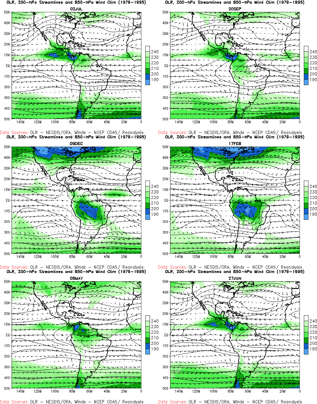
NOAA Updates its Seasonal Outlook on June 20, 2024 – Similar to the Outlook Issued last Month – Posted on June 21, 2024

On the third Thursday of the month right on schedule NOAA issued their updated Seasonal Outlook which I describe as their Four-Season Outlook because it extends a bit more than one year into the future. The information released also included the Mid-Month Outlook for the following month plus the weather and drought outlook for the next three months.  I present the information issued by NOAA and try to add context to it. It is quite a challenge for NOAA to address the subsequent month, the subsequent three-month period as well as the twelve successive three-month periods for a year or a bit more.

With respect to the long-term part of the Outlook which I call the Four-Season Outlook, there is a rapid transition from Neutral to LaNina. So getting the timing right is challenging. We are now in ENSO Neutral. La Nina is the likely scenario for this summer almost to the end of the forecast period. The Outlook beyond June has not been significantly changed from what was issued last month. This suggests increasing confidence in the outlook.  The forecast is a canonical La Nina plus trends.

First, Let’s Take a Look at the (mid-month) Outlook for July

It will be updated on the last day of June.

The top row is what is now called the Mid-Month Outlook for next month which will be updated at the end of this month. There is a temperature map and a precipitation map. The second row is a three-month outlook that includes next month.  I think the outlook maps are self-explanatory. What is important to remember is that they show deviations from the current definition of normal which is the period 1991 through 2020.  So this is not a forecast of the absolute value of temperature or precipitation but the change from what is defined as normal or to use the technical term “climatology”.

Notice that the Outlook for next month and the three-month Outlook are somewhat different, especially about precipitation.  This tells us that August and September will be different than July to some extent.

The expansion of the area impacted by drought is extensive.

The full NOAA Seasonal Outlook extends through July/August/September of 2025 (yes that is more than a year out). All of these maps are in the body of the article. Large maps are provided for July and the three-month period July/August/September.  Small maps are provided beyond that through July/August/September of 2025 with a link to get larger versions of these maps.

NOAA provides a discussion to support the maps. It is included in the body of this article. In some cases, one will need to click on “read more” to read the full article.  For those on my email list where I have sent the url of the article, that will not be necessary.

Today Through the Fourth Friday (22 to 28 days) Weather Outlook for the U.S. and a Six-Day Forecast for the World: posted June 21, 2024

This article focuses on what we are paying attention to in the next 48 to 72 hours. The article also includes weather maps for longer-term U.S. outlooks and a six-day World weather outlook which can be very useful for travelers.

First the NWS Short Range Forecast. The afternoon NWS text update can be found here after about 4 p.m. New York time but it is unlikely to have changed very much from the morning update. The images in this article automatically update.

Short Range Forecast Discussion
NWS Weather Prediction Center College Park MD
Fri Jun 21 2024
Valid 12Z Fri Jun 21 2024 – 12Z Sun Jun 23 2024

…Record hot temperatures continue over portions of the Midwest/Ohio
Valley while expanding over the Mid-Atlantic…

…Heavy rain and flash flooding concerns across the Upper Midwest Friday
and Great Lakes Saturday…

…Risk for flash flooding in the Four Corners Region Friday…

…Heat building over much of the West heading into the weekend…

A stubborn upper-level high over portions of the eastern to south-central
U.S. will generally remain in place, continuing a heat wave over the
region with the focus for the most intense heat over portions of the
Midwest/Ohio Valley and expanding in the Mid-Atlantic. Forecast
temperatures generally in the mid-90s Friday will rise into the upper 90s
to 100 Saturday in the Mid-Atlantic, with record-tying/breaking
temperatures possible. Heat-related Advisories and Warnings are in place
as these temperatures, when combined with the humidity, will bring heat
index values into the 100-105 degree range, with values as high as 110
possible through the southern Mid-Atlantic on Saturday. Additionally,
overnight low temperatures will remain in the mid-70s for many locations,
at potential record-tying/breaking levels, providing little relief from
the heat overnight. The early arrival of this heat in the Summer season,
persistence over multiple days, and abundant sunshine will aggravate heat
stress on those without reliable air conditioning. Temperatures more
broadly from the East Coast to the central/southern Plains will be in the
low 90s Friday and mid-90s Saturday. Meanwhile, relief continues to the
north of a frontal boundary draped though southern New England, with highs
now mostly in the 70s and low 80s.

Meanwhile, areas of showers and thunderstorms will continue along this
frontal boundary to the north of the upper-high, as moisture from the Gulf
flows northward through the Plains and around eastward through the Upper
Great Lakes and into New England. The greatest threat for significant
heavy rainfall will be ahead of a surface wave over portions of the Upper
Midwest as overnight storm complexes help prime the soils Thursday
night/Friday morning ahead of another round of storms expected later
Friday. A Moderate Risk of Excessive rainfall (level 3/4) is in effect
Friday centered on southern Minnesota and adjacent west-central Wisconsin,
northern Iowa, and southeastern South Dakota, where the highest potential
for heavy downpours, several inches of rainfall, and scattered to numerous
instances of flash flooding exists. Additional scattered instances of
flash flooding will be possible more broadly across the Upper Midwest. A
few severe thunderstorms are expected as well, as the Storm Prediction
Center has included a Slight Risk of severe weather (level 2/5) for the
region, extending southwestward into the central Plains and the
northwestward into the central/northern High Plains. Damaging winds, large
hail, and a few tornadoes are all possible. An upper-level shortwave
approaching from the west will help to deepen the frontal wave and push
the system eastward on Saturday, bringing the threat for heavy rainfall to
portions of the Great Lakes southwestward into the Upper Mississippi
Valley. A Slight Risk of Excessive Rainfall (level 2/4) is in place
Saturday as an organized complex of storms is expected to follow the
system eastward, bringing additional locally heavy rainfall and scattered
instances of flash flooding. Some severe thunderstorms will again be
possible with a Slight Risk in place mainly for the threat of damaging
winds.

An upper-level trough moving over the Southwest will bring areas of
showers and thunderstorms to the Four Corners Region on Saturday.
Anomalously high moisture spreading into the region from the remnants of
former T.S. Alberto will help contribute to locally heavy downpours and
the threat for flash flooding, with a Slight Risk of Excessive Rainfall in
effect Friday. The focus for storms should shift more into portions of the
Desert Southwest on Saturday, with a lingering threat of some isolated
flash flooding. As this trough moves eastward, a ridge will begin to build
over the West in its wake, bringing and expanding area of hot, above
average Summer temperatures. Forecast highs in the 90s on Friday will soar
into the 100s on Saturday for portions of the Great Basin and central
California Valleys. Heat-related Advisories and Watches have been issued
for the central Valleys south into interior southern California beginning
Saturday. Conditions will also be notably hot over the Desert Southwest on
Friday, particularly over central Arizona where Excessive Heat Warnings
are in place, with highs into the 110s. The noted increasing
moisture/storm chances will help cool temperatures down a few degrees
Saturday. Elsewhere, a couple of waves of low pressure will pass over
portions of the Southeast/Florida as well as south Texas, with daily
thunderstorms chances Friday and Saturday.

To get your local forecast plus active alerts and warnings click HERE and enter your city, state or zip code.

Learn about wave patterns HERE.

Then, looking at the world and of course, the U.S. shows here also. Today we are looking at precipitation.

Please click on “Read More” below to access the full Daily Report issued today.

Today Through the Fourth Friday (22 to 28 days) Weather Outlook for the U.S. and a Six-Day Forecast for the World: posted June 20, 2024

This article focuses on what we are paying attention to in the next 48 to 72 hours. The article also includes weather maps for longer-term U.S. outlooks and a six-day World weather outlook which can be very useful for travelers.

First the NWS Short Range Forecast. The afternoon NWS text update can be found here after about 4 p.m. New York time but it is unlikely to have changed very much from the morning update. The images in this article automatically update.

Short Range Forecast Discussion
NWS Weather Prediction Center College Park MD
Thu Jun 20 2024
Valid 12Z Thu Jun 20 2024 – 12Z Sat Jun 22 2024

…Heavy rain/flooding threats and gusty winds over South Texas gradually
decrease today as Tropical Storm Alberto makes landfall in Mexico and
dissipates…

…Heavy rain and flash flooding concerns increase across the northern
Plains to the upper Midwest later Thursday into Friday as scattered
thunderstorms could result in localized flooding issues from the southern
High Plains to the Four Corners…

…A heat wave will persist over the Great Lakes, Ohio Valley, and
portions of the Northeast into the weekend as heat intensifies in the
western U.S….

Tropical Storm Alberto centered over the southwestern Gulf of Mexico has
begun heading west toward northern Mexico early this morning. Organized
bands of heavy rain extending north from the center have already brought
close to 10 inches of rain locally near the mid-Texas coast. As the heavy
rain bands continue to steadily move west through the Rio Grande Valley
into northern Mexico today, the heavy rain and flooding threats will
gradually decrease across South Texas. Strong and gusty winds will also
gradually weaken with time. Some of the tropical moisture from Alberto
will be drawn northward and energize the scattered showers and
thunderstorms from the southern High Plains to the Four Corners heading
into the weekend. These showers/storms will be more numerous during the
late afternoon to early evening hours in these areas.

Meanwhile, the National Hurricane Center continues to monitor the
potential of tropical cyclone formation over the western Atlantic as a
tropical wave moves west-northwest in the general direction of
northeastern Florida and Georgia. Some enhanced rainfall with gusty winds
can be expected to reach these areas Thursday night and will likely linger
through much of Friday.

Across the northern tier states, relatively less active weather is
expected today as a high pressure system brings cooler and more stable air
from Canada. However, the next piece of energy exiting the central
Rockies will set up the next episode of heavy rain and strong to severe
storms across the northern Plains to the upper Midwest beginning tonight.
A couple rounds of heavy rain focusing just north of a nearly stationary
front across the region will result in slight to moderate risks of
excessive rainfall from eastern South Dakota, across southern Minnesota
into western Wisconsin through Saturday morning. Farther east, scattered
thunderstorms are likely across the Great Lakes region and the Northeast
near and north of the stationary front. Marginal to slight risks of
severe storms are delineated each day from the Storm Prediction Center
(mainly for the threat of severe wind but with some low chances for hail),
and marginal risks of excessive rainfall are in place as well.

All these rain and thunderstorm areas are taking place along the periphery
of an upper ridge/heat dome that edges from the Mid-Atlantic into the
Mid-South over the next couple of days and sustains a heat wave across the
Great Lakes, Northeast, and Mid-Atlantic. Afternoon high temperatures and
warm overnight lows will challenge daily records and even some monthly and
all-time records. Heat index readings are expected to peak from 100 to 105
degrees in many locations. Those without access to reliable air
conditioning are urged to find a way to cool down. Record warm overnight
temperatures will prevent natural cooling and allow the heat danger to
build over time indoors without air conditioning. Temperatures may be
lower and less hazardous closer to the coast if/where sea breezes form. By
Friday, conditions should improve over New England as cooler air dips a
bit farther south into the area behind a front, but temperatures well into
the 90s and higher heat indices are forecast to continue across the Ohio
Valley to Mid-Atlantic. Meanwhile, cooler than average highs are likely
into the southern High Plains with the clouds and rain forecast, but
temperatures over the West will gradually rise above normal Thursday and
Friday. In the western U.S., it appears that the heat will increase by
Saturday as triple-digit high temperatures are forecast for the Central
Valley of California and the Great Basin.

To get your local forecast plus active alerts and warnings click HERE and enter your city, state or zip code.

Learn about wave patterns HERE.

Then, looking at the world and of course, the U.S. shows here also. Today we are looking at precipitation.

Please click on “Read More” below to access the full Daily Report issued today.
Today Through the Fourth Friday (22 to 28 days) Weather Outlook for the U.S. and a Six-Day Forecast for the World: posted June 19, 2024

This article focuses on what we are paying attention to in the next 48 to 72 hours. The article also includes weather maps for longer-term U.S. outlooks and a six-day World weather outlook which can be very useful for travelers.

First the NWS Short Range Forecast. The afternoon NWS text update can be found here after about 4 p.m. New York time but it is unlikely to have changed very much from the morning update. The images in this article automatically update.

Short Range Forecast Discussion
NWS Weather Prediction Center College Park MD
Wed Jun 19 2024
Valid 12Z Wed Jun 19 2024 – 12Z Fri Jun 21 2024

…Significant heavy rain/flash flooding threat with gusty winds well
ahead of Potential T.C. One expected to impact southern Texas today…

…A heat wave will persist over the Midwest, Great Lakes, Ohio Valley and
the Northeast into late week…

…Thunderstorms and heavy rain become less active across the
north-central today into Thursday but may reload across the northern
Plains Thursday night/early Friday…

With the last piece of the potent upper-level energy exiting into southern
Canada, the weather across the northern tier states will be less busy than
recent days. Meanwhile, Potential Tropical Cyclone One (PTC1) is making a
headline as the heavy rain and tropical-storm-force winds well north of
the center of circulation are poised to move onshore and head inland
across southern Texas today. It appears that the lower and middle Texas
coasts will be the locations that will most likely be impacted by the
heavy rain and gale force winds. A coastal front may enhance the heavy
rainfall just inland from the coast but how sharp this front will get
is uncertain at this point. Meanwhile, the strong Bermuda High that will
help sustain the heat wave across the Ohio Valley to the Northeast will
also help steer PTC1 westward toward northern Mexico today as PTC1 could
acquire tropical storm (TS) status before making landfall early on
Thursday. The heavy rain well north of TS1 will likewise move west across
southern Texas and into the Rio Grand Valley through tonight, resulting in
rainfall totals of 5 to 10 inches from northeast Mexico into South Texas
with maximum totals of 15 inches possible. Winds associated with TS1 will
weaken rapidly over northern Mexico as the heaviest rainfall is forecast
to move west of the Rio Grand Valley into northern Mexico and begin to
taper off early on Friday. Meanwhile, some of the tropical moisture from
TS1 is forecast to stream north and trigger showers and thunderstorms
across the Four Corners region by Thursday and into Friday.

As the aforementioned upper-level energy and associated low pressure
system moves farther into Canada, the thunderstorms and heavy rain from
the central Plains to the upper Midwest will become less active today.
The trailing front from the low will become nearly stationary from west to
east across the northern tier states during the next couple of days. The
next piece of upper-level energy ejecting from the central Rockies will
begin to interact with the stationary front late on Thursday and
reinvigorate heavy rain and strong thunderstorms across the northern
Plains and toward the upper Midwest into Friday morning.

Meanwhile, a heat wave will continue to impact areas from the Midwest into
much of the Ohio Valley, Great Lakes, Northeast and Mid-Atlantic through
the next few days. Afternoon high temperatures and warm overnight lows
will likely challenge daily records and even some monthly records. Heat
index readings are expected to peak from 100 to 105 degrees in many
locations. Those without access to reliable air conditioning are urged to
find a way to cool down. Record warm overnight temperatures will prevent
natural cooling and allow the heat danger to build over time indoors
without air conditioning. Conditions are expected to improve over New
England this weekend.

To get your local forecast plus active alerts and warnings click HERE and enter your city, state or zip code.

Learn about wave patterns HERE.

Then, looking at the world and of course, the U.S. shows here also. Today we are looking at precipitation.

Please click on “Read More” below to access the full Daily Report issued today.