Impact of Drought on Hydro Power – Posted on August 24, 2024

A recent study found drought in the United States has led to approximately 300 million MWh in lost hydropower and $28 billion in lost revenue between 2003 and 2020.

Unraveling the hydropower vulnerability to drought in the United States

Pouya Moghaddasi
et al 2024
Environ. Res. Lett. 19 084038 DOI 10.1088/1748-9326/ad6200

Pouya Moghaddasi1,2,* , Keyhan Gavahi1,2, Hamed Moftakhari1,2 and Hamid Moradkhani1,2,*

Published 23 July 2024 © 2024 The Author(s). Published by IOP Publishing Ltd
Environmental Research Letters, Volume 19, Number 8 Citation Pouya Moghaddasi et al 2024 Environ. Res. Lett. 19 084038 DOI 10.1088/1748-9326/ad6200

This article is OPEN ACCESS  so  I have reproduced it here in its entirety.  It is very well written so  I have not seen the need to add comments to the article but  I might highlight certain sentences.  I will provide one caution which is that the period studied is a period that was characterized by a lot of drought so it may not be fully representative of the future.

Abstract

Drought, a potent natural climatic phenomenon, significantly challenges hydropower systems, bearing adverse consequences for economies, societies, and the environment. This study delves into the profound impact of drought on hydropower generation (HG) in the United States, revealing a robust correlation between hydrologic drought and hydroelectricity generation. Our analysis of the period from 2003 to 2020 for the Contiguous United States (CONUS) indicates that drought events led to a considerable decline in hydroelectricity generation, amounting to approximately 300 million MWh, and resulting in an estimated loss of $28 billion to the sector. Moreover, our findings highlight the adverse environmental effect of drought-induced HG reductions, which are often compensated by increased reliance on natural gas usage, which led to substantial emissions of carbon dioxide (CO2), sulfur dioxide (SO2), and nitrogen oxide (NOX), totaling 161 700 kilotons, 1199 tons, and 181 977 tons, respectively. In addition to these findings, we assess the state-level vulnerability of hydropower to drought, identifying Washington and California as the most vulnerable states, while Nevada exhibits the least vulnerability. Overall, this study enhances understanding of the multifaceted effects of drought on hydropower, which can assist in informing policies and practices related to drought management and energy production.

Some may need to click on “read more”  to access the full article.

Today Through the Fourth Friday (22 to 28 days) Weather Outlook for the U.S. and a Six-Day Forecast for the World: posted August 24, 2024

This article focuses on what we are paying attention to in the next 48 to 72 hours. The article also includes weather maps for longer-term U.S. outlooks and a six-day World weather outlook which can be very useful for travelers.

First the NWS Short Range Forecast. The afternoon NWS text update can be found here after about 4 p.m. New York time but it is unlikely to have changed very much from the morning update. The images in this article automatically update.

Short Range Forecast Discussion
NWS Weather Prediction Center College Park MD
Sat Aug 24 2024
Valid 12Z Sat Aug 24 2024 – 12Z Mon Aug 26 2024

…Monsoonal thunderstorms across the Four Corners this weekend will edge
east toward southern Rockies by early next week producing locally
excessive rainfall…

…Record heat relents over the Southern Plains as record cool
temperatures envelop California to the Great Basin…

…Critical Fire Risk and Red Flag Warnings in effect across much of the
Great Basin…

An anomalously amplified weather pattern across North America will
continue to bring sharply contrasting weather conditions across the U.S.
for the next couple of days. This weather pattern will feature a warm
upper high over the southern Plains sandwiched in between two deep and
cold upper lows/troughs on either side of the West and East Coasts. An
unstable channel of moist southwesterly flow between the ridge and the
upper low near the Pacific Northwest will continue to support monsoonal
showers and embedded thunderstorms across the Four Corners region today,
shifting only slightly east toward the southern Rockies by Monday when the
flash flooding threat dwindles further as the upper high begins to give
way to the upper low moving inland across the western U.S. Farther north
across the northern High Plains, a couple of new low pressure systems are
forecast to form one after another and move toward southern Canada through
the next couple of days, bringing gusty winds but only modest amounts of
rainfall. Some of the thunderstorms could become severe near the Canadian
border of Montana early this morning ahead of the first low pressure
system. Meanwhile, critical fire weather danger is forecast for the Great
Basin under blustery and dry conditions behind a cold front.

The large upper low dipping into the Pacific Northwest will continue to
provide very cool and damp conditions into the West Coast today. In fact,
record cool high temperatures can be found once again today across
California and into the Great Basin. The anomalous cool conditions will
penetrate farther inland and overspread much of the western U.S. by
Sunday. In contrast, the heatwave across the southern Plains is showing
signs of relenting as the cool air from the western U.S. begins to erode
the upper ridge. Nevertheless, another afternoon with triple digit high
temperatures are forecast for today over a large portions of Texas into
the central Plains behind a warm front and associated low pressure center.
With relatively little moisture to work with, the low pressure system
will produce generally light amounts of rain. However, some heavy
rainfall can be expected to associate with localized clusters of strong
thunderstorms across the Midwest this weekend.

Meanwhile, cool mornings, increasingly warm afternoons and abundant
sunshine will prevail across much of the eastern U.S. under a cool upper
trough together with a cool high pressure system at the surface. A gradual
warming trend will continue across the eastern half of the country through
the next couple of days as the high pressure system begins to slide off
the East Coast. Afternoon high temperatures will recover to the lower 90s
by Sunday afternoon for some urban locations along the East Coast.
Meanwhile, high temperatures well into the 90s will be common across the
northern and central Plains ahead of a warm front lifting across the
mid-section of the country and ahead of a cold front in advance of the
cool air over the western U.S.

To get your local forecast plus active alerts and warnings click HERE and enter your city, state or zip code.

Learn about wave patterns HERE.

Then, looking at the world and of course, the U.S. shows here also. Today we are looking at precipitation.

Please click on “Read More” below to access the full Daily Report issued today.

Today Through the Fourth Friday (22 to 28 days) Weather Outlook for the U.S. and a Six-Day Forecast for the World: posted August 23, 2024

This article focuses on what we are paying attention to in the next 48 to 72 hours. The article also includes weather maps for longer-term U.S. outlooks and a six-day World weather outlook which can be very useful for travelers.

First the NWS Short Range Forecast. The afternoon NWS text update can be found here after about 4 p.m. New York time but it is unlikely to have changed very much from the morning update. The images in this article automatically update.

Short Range Forecast Discussion
NWS Weather Prediction Center College Park MD
Fri Aug 23 2024
Valid 12Z Fri Aug 23 2024 – 12Z Sun Aug 25 2024

…Monsoonal thunderstorms could lead to excessive rainfall for much of
the Four Corners region today and into the weekend…

…Record heat begins to relent over the Southern Plains this weekend but
near record cool in the eastern U.S. and California…

…Critical Fire Risk and Red Flag Warnings in effect across much of the
Great Basin…

An anomalously amplified weather pattern across North America will
continue to bring sharply contrasting weather conditions across the U.S.
as we head into the weekend. This weather pattern will feature a warm
upper high over the southern Plains sandwiched in between two deep and
cold upper lows/troughs on either side of the West and East Coasts. A
deep and unstable southwesterly flow between the ridge and the upper low
near the Pacific Northwest will support monsoonal showers and
thunderstorms across the Four Corners region through the next few days,
especially early this morning when severe thunderstorms are advancing
farther downstream into the central Plains. Slot canyons and burn scars
are particularly vulnerable to flash flooding. The flash flooding threat
dwindles a bit heading into the weekend as the upper-ridge shifts slightly
eastward and the main energy associated with the upper low will be
directed farther north toward the northern High Plains where a new low
pressure system is forecast to form by Saturday night. Meanwhile,
critical fire weather danger is forecast for the Great Basin under gusty
and dry conditions behind a cold front.

The large upper low dipping into the Pacific Northwest will continue to
provide very cool and damp conditions into the West Coast today. In fact,
record cool high temperatures can be found today across California. The
anomalous cool conditions will penetrate farther inland during the
weekend, overspreading much of the western U.S. by Sunday morning. In
contrast, another afternoon of record high temperatures are forecast for
portions of Texas into Oklahoma under the warm upper high where 110s are
possible in portions of Texas Panhandle into nearby Oklahoma. This
heatwave is showing signs of relenting by this weekend as the cool air
from the western U.S. upper trough begins to erode the upper ridge.
However, heat indices are forecast to reach into the upper 90s to the mid
100s during the weekend while the heat begins to spread northward into the
central Plains.

Meanwhile, very cool and pleasant weather for August will continue to
prevail across much of the eastern U.S. under the cool upper trough
together with a cool high pressure system at the surface. In fact, record
cool temperatures are possible this morning across portions of the
Mid-Atlantic, central Appalachians, and interior Southeast with
temperatures dipping as cold as the 40s. A gradual warming trend is
expected through the weekend for the eastern half of the country as the
high pressure system begins to slide off the East Coast.

To get your local forecast plus active alerts and warnings click HERE and enter your city, state or zip code.

Learn about wave patterns HERE.

Then, looking at the world and of course, the U.S. shows here also. Today we are looking at precipitation.

Please click on “Read More” below to access the full Daily Report issued today.

Today Through the Fourth Friday (22 to 28 days) Weather Outlook for the U.S. and a Six-Day Forecast for the World: posted August 22, 2024

This article focuses on what we are paying attention to in the next 48 to 72 hours. The article also includes weather maps for longer-term U.S. outlooks and a six-day World weather outlook which can be very useful for travelers.

First the NWS Short Range Forecast. The afternoon NWS text update can be found here after about 4 p.m. New York time but it is unlikely to have changed very much from the morning update. The images in this article automatically update.

Short Range Forecast Discussion
NWS Weather Prediction Center College Park MD
Thu Aug 22 2024
Valid 12Z Thu Aug 22 2024 – 12Z Sat Aug 24 2024

…Record heat continues into the end of the week across the Southern
Plains…

…There is a Slight Risk of excessive rainfall over parts of the
Southwest, Great Basin, and Central/Southern Rockies on Thursday…

…Record cold develops across California Friday into Saturday…

…There are Excessive Heat Warnings and Heat Advisories over parts of the
Southern Plains…

A front over the Pacific Northwest Coast will move slowly eastward to the
Northern High Plains to the Great Basin and then into Southeastern
California by Saturday. The boundary will be on the leading edge of an
upper-level trough, bringing colder temperatures in the mid-70s to
California. The associated upper-level low will develop rain over parts of
the Pacific Northwest and Northern California through Saturday.

Furthermore, monsoonal moisture and upper-level energy will aid in
producing showers and thunderstorms with heavy rain over parts of
southeastern Utah, northern Arizona, southwestern Colorado, and
northwestern New Mexico. Therefore, the WPC has issued a Slight Risk
(level 2/4) of excessive rainfall over parts of the Southwest, Great
Basin, and Central/Southern Rockies through Friday morning. The
associated heavy rain will create mainly localized areas of flash
flooding, with urban areas, roads, small streams, low-lying areas, narrow
canyons/gullies, and burn scars the most vulnerable.

The threat of excessive rainfall will decrease slightly over the Four
Corners Region on Friday. However, there will still be a threat of heavy
rain. Therefore, the WPC has issued a Marginal Risk (level 1/4) of
excessive rainfall over parts of the Southwest, Great Basin, and
Central/Southern Rockies from Friday into Saturday morning. The
associated heavy rain will create localized areas of flash flooding,
affecting low-lying areas, narrow canyons/gullies, and burn scars that
experience rapid runoff with heavy rain.

Additionally, a second front extending from the Northern Plains to the
Great Basin will move northward as a warm front over the Northern Tier
States by Saturday. On Thursday, the boundary will produce showers and
thunderstorms over parts of the Northern/Central Plains into parts of the
Upper Mississippi Valley. The showers and thunderstorms will expand into
parts of the Upper Great Lakes and Middle Mississippi Valley on Friday.

Moreover, another upper-level low over the Northeast will help create rain
with an embedded thunderstorm over parts of the Northeast through late
Thursday night. Further, an area of upper-level energy moving into the
Southeast will develop a weak upper-level low by Thursday evening. With
ample moisture over the area and a lingering boundary, showers and
thunderstorms will develop over parts of the Southeast through Saturday.

Additionally, upper-level energy trapped under an upper-level high and
moisture moving northward off the Gulf of Mexico will create scattered
showers and thunderstorms over parts of the Southern Plains through
Saturday.

Meanwhile, the upper-level high over the Southern Plains will allow high
temperatures to be in the upper 90s and low 100s, with dew points in the
upper 60s and low 70s, prompting Excessive Heat Warnings and Advisories
over parts of the Southern Plains. Additionally, with low temperatures in
the lower 80s and upper 70s, little relief from the heat will occur
overnight. Therefore, people spending more time or effort outdoors or in a
building without cooling in areas with heat warnings are still at an
increased risk of heat-related illness.

To get your local forecast plus active alerts and warnings click HERE and enter your city, state or zip code.

Learn about wave patterns HERE.

Then, looking at the world and of course, the U.S. shows here also. Today we are looking at precipitation.

Please click on “Read More” below to access the full Daily Report issued today.

Today Through the Fourth Friday (22 to 28 days) Weather Outlook for the U.S. and a Six-Day Forecast for the World: posted August 21, 2024

This article focuses on what we are paying attention to in the next 48 to 72 hours. The article also includes weather maps for longer-term U.S. outlooks and a six-day World weather outlook which can be very useful for travelers.

First the NWS Short Range Forecast. The afternoon NWS text update can be found here after about 4 p.m. New York time but it is unlikely to have changed very much from the morning update. The images in this article automatically update.

Short Range Forecast Discussion
NWS Weather Prediction Center College Park MD
Wed Aug 21 2024
Valid 12Z Wed Aug 21 2024 – 12Z Fri Aug 23 2024

…There is a Slight Risk of excessive rainfall over parts of the
Southwest and Great Basin on Wednesday and expanding into parts of the
Central/Southern Rockies on Thursday…

…There is a Slight Risk of severe thunderstorms over parts of the
Northern High Plains on Wednesday…

…There are Excessive Heat Warnings and Heat Advisories over parts of the
Southern Plains…

A front over the Northern Rockies will move slowly eastward to the
Northern Plains by Friday. The boundary will produce showers and severe
thunderstorms over northeastern Montana and northwestern North Dakota.
Therefore, the SPC has issued a Slight Risk (level 2/5) of severe
thunderstorms over parts of the Northern High Plains through Thursday
morning. The hazards associated with these thunderstorms are frequent
lightning, severe thunderstorm wind gusts, hail, and a minimal threat of
tornadoes. However, there is an increased threat of severe thunderstorm
wind gusts 65 knots or greater.

In addition, an upper-level low over the Northeast will help create rain
with an embedded thunderstorm over parts of the Northeast through
Thursday. Moreover, upper-level energy over the Middle Mississippi Valley
will move southeastward to the Southeast, developing a weak upper-level
low by Thursday evening. With ample moisture over the area, showers and
thunderstorms will develop over parts of the Southeast through Friday.

Furthermore, monsoonal moisture and upper-level energy will aid in
producing showers and thunderstorms with heavy rain over parts of Arizona
and southern Utah. Therefore, the WPC has issued a Slight Risk (level
2/4) of excessive rainfall over parts of the Southwest and Great Basin
through Thursday morning. The associated heavy rain will create mainly
localized areas of flash flooding, with urban areas, roads, small streams,
low-lying areas, narrow canyons/gullies, and burn scars the most
vulnerable.

On Thursday, the monsoonal moisture will extend farther northward over the
area. Likewise, the upper-level energy and monsoonal moisture will produce
showers and thunderstorms with heavy rain over parts of southeastern Utah,
northern Arizona, southwestern Colorado, and northwestern New Mexico.
Therefore, the WPC has issued a Slight Risk (level 2/4) of excessive
rainfall over parts of the Southwest, Great Basin, and Central/Southern
Rockies from Thursday through Friday morning. The associated heavy rain
will create mainly localized areas of flash flooding, with urban areas,
roads, small streams, low-lying areas, narrow canyons/gullies, and burn
scars the most vulnerable.

Moreover, as the front over the Northern High Plains moves eastward on
Thursday, showers and strong to severe thunderstorms will develop over
parts of the Northern/Central Plains and the Central High Plains.
Therefore, the SPC has issued a Marginal Risk (level 1/5) of severe
thunderstorms over parts of the Northern/Central Plains and the Central
High Plains from Thursday into Friday morning. The hazards associated with
these thunderstorms are frequent lightning, severe thunderstorm wind
gusts, hail, and a minimal threat of tornadoes.

Elsewhere, as upper-level low moves southward along the Northwest Coast
will develop rain over parts of the Pacific Northwest through Friday.

Meanwhile, an upper-level high over the Southern Plains will allow high
temperatures to be in the upper 90s and low 100s, with dew points in the
upper 60s and low 70s, prompting Excessive Heat Warnings and Advisories
over parts of the Southern Plains. Additionally, with low temperatures in
the lower 80s and upper 70s, little relief from the heat will occur
overnight. Therefore, people spending more time or effort outdoors or in a
building without cooling in areas with heat warnings are still at an
increased risk of heat-related illness.

To get your local forecast plus active alerts and warnings click HERE and enter your city, state or zip code.

Learn about wave patterns HERE.

Then, looking at the world and of course, the U.S. shows here also. Today we are looking at precipitation.

Please click on “Read More” below to access the full Daily Report issued today.

Today Through the Fourth Friday (22 to 28 days) Weather Outlook for the U.S. and a Six-Day Forecast for the World: posted August 20, 2024

This article focuses on what we are paying attention to in the next 48 to 72 hours. The article also includes weather maps for longer-term U.S. outlooks and a six-day World weather outlook which can be very useful for travelers.

First the NWS Short Range Forecast. The afternoon NWS text update can be found here after about 4 p.m. New York time but it is unlikely to have changed very much from the morning update. The images in this article automatically update.

Short Range Forecast Discussion
NWS Weather Prediction Center College Park MD
Tue Aug 20 2024
Valid 12Z Tue Aug 20 2024 – 12Z Thu Aug 22 2024

…Severe thunderstorms possible across the central to northern High
Plains through Wednesday with flash flood potential continuing over the
Southwest…

…Record breaking heat continues across Texas…

After several days of active and unsettled weather, the cold front across
the eastern U.S. has finally largely cleared the coast, aside from coastal
Maine where a few lingering showers will remain possible through this
morning. Otherwise, sprawling high pressure will encompass much of the
Great Lakes region through the East, bringing much drier conditions and
generally below normal temperatures for the next couple of days. High
temperature departures of 10 to nearly 20 degrees for mid-August are
expected for Great Lakes and Northeast. Plan on highs only in the 60s and
70s for many areas from the Midwest to northern Mid-Atlantic and
Northeast. This high pressure is expected to dominate the weather story
for the region through at least mid-week, from the Mississippi River to
the Appalachians.

A nearly stationary front will settle to its south across the Gulf Coast
region and then extending northward across the High Plains, along the
western periphery of the high pressure axis. This boundary, along with
interactions with another passing weather system passing through the
Northern Rockies, will bring threats for severe thunderstorms to much of
the central and northern High Plains through Wednesday. The Storm
Prediction Center is advertising a Slight Risk (Level 2 of 5) for severe
weather including damaging winds and large hail.

Meanwhile, deep monsoonal moisture persistent over the Southwest U.S. will
bring a daily threat of localized and isolated flash flooding. Slow moving
but intense rainfall producing thunderstorms are possible across portions
of Arizona, Utah, Colorado, and New Mexico. For today, the threat appears
to be fairly localized, a greater threat will exist for Wednesday across
northern Arizona where a Slight Risk (Level 2 of 4) of excessive rainfall
and flash flooding exists.

Finally, underneath a strong upper level ridge, record breaking heat will
continue for at least a couple more days across portions of Texas and
southern Oklahoma. Excessive Heat Warnings and Heat Advisories remain in
effect and many daily record high temperatures will be possible as
temperatures soar into the 90s and triple digits. Combined with the
oppressive humidity, daily maximum heat indices up to 110F will be
possible. This will create a dangerous situation for some groups,
particularly anyone spending large amounts of time outdoors. They will be
at a heightened risk of heat-related illness. Some of the heat is expected
to spread into eastern New Mexico by the middle/end of the week.

To get your local forecast plus active alerts and warnings click HERE and enter your city, state or zip code.

Learn about wave patterns HERE.

Then, looking at the world and of course, the U.S. shows here also. Today we are looking at precipitation.

Please click on “Read More” below to access the full Daily Report issued today.

Today Through the Fourth Friday (22 to 28 days) Weather Outlook for the U.S. and a Six-Day Forecast for the World: posted August 19, 2024

This article focuses on what we are paying attention to in the next 48 to 72 hours. The article also includes weather maps for longer-term U.S. outlooks and a six-day World weather outlook which can be very useful for travelers.

First the NWS Short Range Forecast. The afternoon NWS text update can be found here after about 4 p.m. New York time but it is unlikely to have changed very much from the morning update. The images in this article automatically update.

Short Range Forecast Discussion
NWS Weather Prediction Center College Park MD
Mon Aug 19 2024
Valid 12Z Mon Aug 19 2024 – 12Z Wed Aug 21 2024

…There is a Slight Risk of excessive rainfall over parts of New England
on Monday…

…There is a Slight Risk of severe thunderstorms over parts of the
Central High Plains on Monday…

…There are Excessive Heat Warnings over parts of the Southern Plains and
Heat Advisories over parts of the Southern Plains and Lower Mississippi
Valley…

A front extending from the Northeast Coast across the
Mid-Atlantic/Southeast Coast and then across the Gulf Coast State will
move off most of the Eastern Seaboard while lingering over the Southeast
by Wednesday. The boundary will produce showers and thunderstorms with
heavy rain over parts of New England as a plume of moisture feds into the
area. Therefore, the WPC has issued a Slight Risk (level 2/4) of excessive
rainfall over parts of New England through Tuesday morning. The
associated heavy rain will create mainly localized areas of flash
flooding, with urban areas, roads, small streams, and low-lying areas the
most vulnerable.

Moreover, showers and thunderstorms will develop along the front from the
Mid-Atlantic to the Southeast and the Gulf Coast State. Showers and
thunderstorms will also develop over parts of the Central Appalachians and
Ohio Valley on Monday.

In addition, on Monday, upper-level energy over the Central Rockies will
interact with ample amounts of moisture to produce showers and severe
thunderstorms over parts of eastern Colorado. Therefore, the SPC has
issued a Slight Risk (level 2/5) of severe thunderstorms over parts of the
Central High Plains through Tuesday morning. The hazards associated with
these thunderstorms are frequent lightning, severe thunderstorm wind
gusts, hail, and a minimal threat of tornadoes.

Furthermore, monsoonal moisture and daytime heating will create showers
and thunderstorms over parts of the Southwest, Eastern Great Basin, and
Northern/Central Rockies from late afternoon into late evening on Monday.
On Tuesday, the showers and thunderstorms will be over a much smaller area
over the Southwest and adjacent regions. Additionally, disorganized
upper-level energy will aid in triggering showers and thunderstorms over
parts of the Northern/Central Plains. Further, on Tuesday, an upper-level
low will move over parts of the Northeast, creating rain over parts of the
area. Additionally, showers and thunderstorms will also develop over parts
of Florida.

As the quasi-stationary front moves southward over the Southern Plains and
Lower Mississippi Valley, the areas under Excessive Heat Warnings and Heat
Advisories have reduced to parts of the Southern Plains and Lower
Mississippi Valley. Moreover, people spending more time or effort outdoors
or in a building without cooling in the areas of heat warnings are still
at an increased risk of heat-related illness.

To get your local forecast plus active alerts and warnings click HERE and enter your city, state or zip code.

Learn about wave patterns HERE.

Then, looking at the world and of course, the U.S. shows here also. Today we are looking at precipitation.

Please click on “Read More” below to access the full Daily Report issued today.

Today Through the Fourth Friday (22 to 28 days) Weather Outlook for the U.S. and a Six-Day Forecast for the World: posted August 18, 2024

This article focuses on what we are paying attention to in the next 48 to 72 hours. The article also includes weather maps for longer-term U.S. outlooks and a six-day World weather outlook which can be very useful for travelers.

First the NWS Short Range Forecast. The afternoon NWS text update can be found here after about 4 p.m. New York time but it is unlikely to have changed very much from the morning update. The images in this article automatically update.

Short Range Forecast Discussion
NWS Weather Prediction Center College Park MD
Sun Aug 18 2024
Valid 12Z Sun Aug 18 2024 – 12Z Tue Aug 20 2024

….There is a Slight Risk of excessive rainfall over parts of the
Mid-Atlantic on Sunday…

…There is a Slight Risk of severe thunderstorms over parts of the
Mid-Atlantic to Southeast/Lower Mississippi Valley on Sunday…

…There are Excessive Heat Warnings and Heat Advisories over parts of the
Southern Plains and Lower Mississippi Valley…

A front extending from the Lower Great Lakes/Ohio Valley across the
Tennessee/Lower Mississippi Valleys and then to the Central High Plains
will move off most of the Eastern Seaboard Atlantic while lingering over
the Southeast and southward off most of the Gulf Coast and then across
parts of the Southern Plains by Tuesday. The boundary will produce showers
and severe thunderstorms from the Mid-Atlantic, Southeast, and Gulf Coast
States. Therefore, the SPC has issued a Slight Risk (level 2/5) of severe
thunderstorms over parts of the Mid-Atlantic to Southeast/Lower
Mississippi Valley through Monday morning. The hazards associated with
these thunderstorms are frequent lightning, severe thunderstorm wind
gusts, hail, and a few tornadoes.

Also, the showers and thunderstorms produced by the boundary will create
heavy rain over parts of the northern Mid-Atlantic. Therefore, through
Monday morning, the WPC has issued a Slight Risk (level 2/4) of excessive
rainfall over parts of the northern Mid-Atlantic. The associated heavy
rain will create mainly localized areas of flash flooding, with urban
areas, roads, small streams, and low-lying areas the most vulnerable.

Additionally, an upper-level low just off the Northwest Coast will produce
rain, with maybe an embedded thunderstorm over parts of the Pacific
Northwest on Sunday. Furthermore, upper-level energy moving over the top
of an upper-level ridge over the Central Plains will produce showers and
thunderstorms over parts of the Central/Southern Plains on Sunday.

Moreover, monsoonal moisture and daytime heating will create showers and
thunderstorms over parts of the Southwest, Eastern Great Basin, and
Northern/Central Rockies from late afternoon into late evening on Sunday
and Monday.

On Monday, showers and thunderstorms will develop over parts of the
Northeast, Mid-Atlantic, and Southeast. While, upper-level energy will
trigger showers and thunderstorms over parts of the Central/Southern
Plains and Lower Mississippi Valley. Further, disorganized upper-level
energy over the Northern Rockies into the Northern Plains will produce
showers and thunderstorms over the region.

Meanwhile, upper-level ridging over parts of the Southern Plains and Lower
Mississippi Valley will produce high temperatures in the low-100s with dew
points in the low to mid-70s, which have prompted Excessive Heat Warnings
and Heat Advisories over parts of the Southern Plains and Lower
Mississippi Valley. The sweltering summer heat will continue over the
south as the prolonged stretch of high temperatures in the triple digits
will focus on portions of the Southern Plains and Gulf Coast through
Tuesday. Low temperatures in the low-80s/upper-70s are also forecast along
the Gulf Coast, providing little relief from the heat overnight. Moreover,
the combination of summer heat and high humidity will support daily
maximum heat indices near 110F. Therefore, people spending more time or
effort outdoors or in a building without cooling are at an increased risk
of heat-related illness.

To get your local forecast plus active alerts and warnings click HERE and enter your city, state or zip code.

Learn about wave patterns HERE.

Then, looking at the world and of course, the U.S. shows here also. Today we are looking at precipitation.

Please click on “Read More” below to access the full Daily Report issued today.

Today Through the Fourth Friday (22 to 28 days) Weather Outlook for the U.S. and a Six-Day Forecast for the World: posted August 17, 2024

This article focuses on what we are paying attention to in the next 48 to 72 hours. The article also includes weather maps for longer-term U.S. outlooks and a six-day World weather outlook which can be very useful for travelers.

First the NWS Short Range Forecast. The afternoon NWS text update can be found here after about 4 p.m. New York time but it is unlikely to have changed very much from the morning update. The images in this article automatically update.

Short Range Forecast Discussion
NWS Weather Prediction Center College Park MD
Sat Aug 17 2024
Valid 12Z Sat Aug 17 2024 – 12Z Mon Aug 19 2024

…There is a Slight Risk of excessive rainfall over parts of the
Mid-Atlantic on Saturday/Sunday and Southwest/Eastern Great Basin on
Saturday…

…There is a Slight Risk of severe thunderstorms over parts of the
Pacific Northwest, Great Basin, and Ohio Valley on Saturday and southern
Mid-Atlantic to Southeast/Lower Mississippi Valley on Sunday…

…There are Excessive Heat Warnings and Heat Advisories over parts of the
Southern Plains and Lower Mississippi Valley…

A front extending from the Great Lakes/Ohio Valley across the Middle
Mississippi Valley and then to the Central High Plains will move eastward
to the Mid-Atlantic/Southeast Coast and southward to the Southern Plains
by Monday. On Saturday, showers and thunderstorms will develop along and
ahead of the boundary from the Great Lakes/Ohio Valley to the
Tennessee/Lower Mississippi Valleys.

Additionally, upper-level energy will intersect a pool of tropical
moisture over the northern Mid-Atlantic, producing heavy rain. Therefore,
the WPC has issued a Slight Risk (level 2/4) of excessive rainfall over
parts of the northern Mid-Atlantic through Sunday morning. The associated
heavy rain will create mainly localized areas of flash flooding, with
urban areas, roads, small streams, and low-lying areas the most
vulnerable.

Furthermore, the boundary will trigger showers and severe thunderstorms
over parts of southwestern Ohio, eastern Kentucky, and extreme
north-central Tennessee. Therefore, the SPC has issued a Slight Risk
(level 2/5) of severe thunderstorms over parts of the Ohio/Tennessee
Valleys through Sunday morning. The hazards associated with these
thunderstorms are frequent lightning, severe thunderstorm wind gusts,
hail, and a few tornadoes.

Moreover, upper-level energy and a plume of monsoonal moisture will aid in
creating showers and thunderstorms with heavy rain over parts of southern
Utah and northwestern Arizona. Therefore, the WPC has issued a Slight Risk
(level 2/4) of excessive rainfall over parts of the Great Basin/Southwest
through Sunday morning. The associated heavy rain will create mainly
localized areas of flash flooding, with urban areas, roads, small streams,
and low-lying areas the most vulnerable.

In addition, the energy will produce showers and severe thunderstorms over
parts of the Great Basin. Therefore, the SPC has issued a Slight Risk
(level 2/5) of severe thunderstorms over parts of the Great Basin through
Sunday morning. The hazards associated with these thunderstorms are
frequent lightning, severe thunderstorm wind gusts, and a minimal threat
of hail and tornadoes.

Also, an upper-level low over the Pacific Northwest Coast and associated
energy will develop showers and severe thunderstorms over parts of Oregon
and Washington State on Saturday. Therefore, the SPC has issued a Slight
Risk (level 2/5) of severe thunderstorms over parts of the Pacific
Northwest through Sunday morning. The hazards associated with these
thunderstorms are frequent lightning, severe thunderstorm wind gusts,
hail, and a minimal threat of tornadoes.

On Sunday, as the front moves into the Mid-Atlantic, Southeast, and Lower
Mississippi Valley, showers and severe thunderstorms will develop along
and ahead of the boundary. Therefore, the SPC has issued a Slight Risk
(level 2/5) of severe thunderstorms over parts of the southern
Mid-Atlantic to Southeast/Lower Mississippi Valley from Sunday through
Monday morning. The hazards associated with these thunderstorms are
frequent lightning, severe thunderstorm wind gusts, hail, and a minimal
threat of tornadoes.

Further, a strong pool of moisture will be over the Mid-Atlantic on
Sunday, aiding in producing showers and thunderstorms with heavy rain over
parts of the northern Mid-Atlantic. Therefore, the WPC has issued a Slight
Risk (level 2/4) of excessive rainfall over parts of the northern
Mid-Atlantic from Sunday through Monday morning. The associated heavy
rain will create mainly localized areas of flash flooding, with urban
areas, roads, small streams, and low-lying areas the most vulnerable.

Moreover, monsoonal moisture and daytime heating will create showers and
thunderstorms over parts of the Southwest, Eastern Great Basin, and
Central Rockies from late afternoon into late evening on Sunday.
Additionally, the upper-level low over the Northwest will produce rain,
with maybe an embedded thunderstorm over the region on Sunday.

Meanwhile, upper-level ridging over parts of the Southern Plains and
Lower Mississippi Valley will produce high temperatures in the upper-90s
to low-100s with dew points in the low to mid-70s have prompted Excessive
Heat Warnings and Heat Advisories over parts of the Southern Plains and
Lower Mississippi Valley. The sweltering summer heat will continue over
the south. A prolonged stretch of high temperatures in the upper 90s and
triple digits will be focused over portions of the Southern Plains and
Gulf Coast through Monday. Low temperatures in the low-80s/upper-70s are
also forecast along the Gulf Coast, providing little relief from the heat
overnight. Moreover, the combination of summer heat and high humidity will
support daily maximum heat indices near 110F. People spending more time or
effort outdoors or in a building without cooling are at an increased risk
of heat-related illness.

To get your local forecast plus active alerts and warnings click HERE and enter your city, state or zip code.

Learn about wave patterns HERE.

Then, looking at the world and of course, the U.S. shows here also. Today we are looking at precipitation.

Please click on “Read More” below to access the full Daily Report issued today.

NOAA Updates its Seasonal Outlook on August 15, 2024 – Similar to the Outlook Issued last Month but Shifted Out a Month or Two – Posted on August 16, 2024

On the third Thursday of the month right on schedule NOAA issued their updated Seasonal Outlook which I describe as their Four-Season Outlook because it extends a bit more than one year into the future. The information released also included the Mid-Month Outlook for the following month plus the weather and drought outlook for the next three months.  I present the information issued by NOAA and try to add context to it. It is quite a challenge for NOAA to address the subsequent month, the subsequent three-month period as well as the twelve successive three-month periods for a year or a bit more.

With respect to the long-term part of the Outlook which I call the Four-Season Outlook, the timing of the transition from Neutral to LaNina is challenging to predict.  We are now in ENSO Neutral. La Nina is the likely scenario soon through winter and into Spring next year.

From the NOAA discussion:

“The major climate driver during the winter and early spring 2024-2025 is expected to be La Niña and the outlooks from DJF 2024-2025 through FMA 2025 reflect this with above-normal temperatures favored for the Southern Great Plains, Lower Mississippi Valley, and Southeast.”

“Later in the fall and into the 2024-2025 winter, the three-month precipitation outlooks are based largely on La Niña composites. The spatial coverage for below-normal precipitation probabilities exceeding 50 percent is largest during DJF and JFM across southeastern New Mexico, Texas, and parts of the Southeast where the dry signal is the strongest and occurs most frequently according to La Niña composites. Based on the same reasoning, above-normal precipitation probabilities are at their largest during DJF for the Pacific Northwest. Typically during La Niña, a tight gradient of dry to wet from the Gulf Coast to the Tennessee and Ohio Valleys becomes established during the winter and early spring.”

I personally would not have total confidence in this outlook given the uncertainty about there actually being a La Nina and its strength if it does happen.  I  do not have the JAMSTEC outlook yet but for sure they will lean towards a weak La Nina with Modoki characteristics. I do not have a lot of confidence that NOAA knows how to deal with a La Nina Modoki. But they may have it exactly correct.

Let’s Take a Look at the (mid-month) Outlook for September

It will be updated on the last day of August.

Then we look at a graphic that shows both the next month and the next three months.

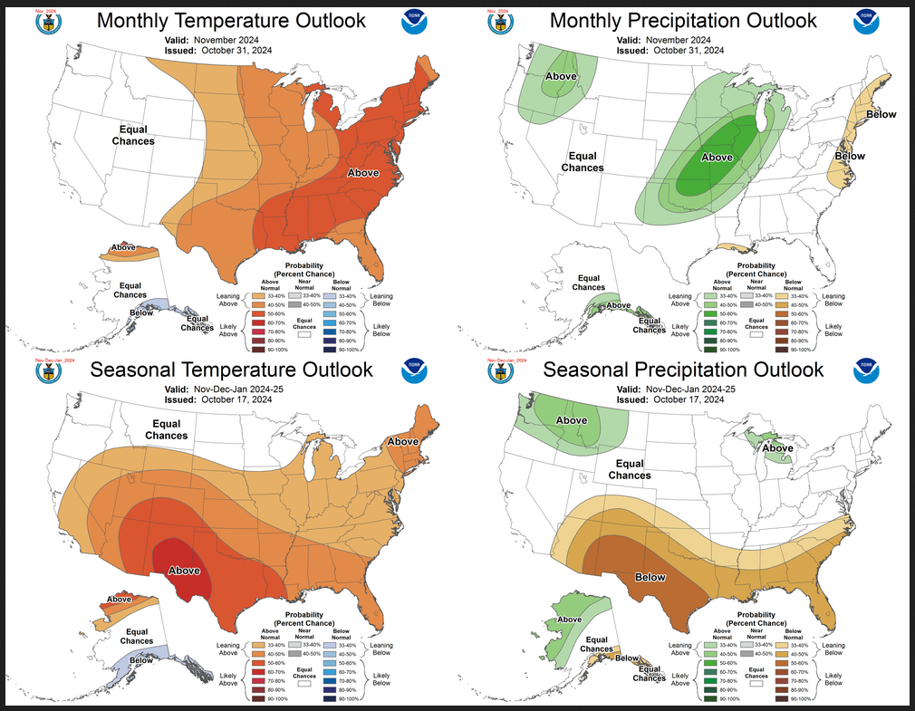
The top row is what is now called the Mid-Month Outlook for next month which will be updated at the end of this month. There is a temperature map and a precipitation map. The second row is a three-month outlook that includes next month.  I think the outlook maps are self-explanatory. What is important to remember is that they show deviations from the current definition of normal which is the period 1991 through 2020.  So this is not a forecast of the absolute value of temperature or precipitation but the change from what is defined as normal or to use the technical term “climatology”.

Notice that the Outlook for next month and the three-month Outlook are fairly similar. This tells us that October and November will be fairly similar to September.

The full NOAA Seasonal Outlook extends through September/October/November of 2025 (yes that is more than a year out). All of these maps are in the body of the article. Large maps are provided for September and the three-month period September/October/November.  Small maps are provided beyond that through September/October/November of 2025 with a link to get larger versions of these maps.

NOAA provides a discussion to support the maps. It is included in the body of this article. In some cases, one will need to click on “read more” to read the full article. For those on my email list where I have sent the url of the article, that will not be necessary.