NOAA Updates its Seasonal Outlook on August 15, 2024 – Similar to the Outlook Issued last Month but Shifted Out a Month or Two – Posted on August 16, 2024
On the third Thursday of the month right on schedule NOAA issued their updated Seasonal Outlook which I describe as their Four-Season Outlook because it extends a bit more than one year into the future. The information released also included the Mid-Month Outlook for the following month plus the weather and drought outlook for the next three months. I present the information issued by NOAA and try to add context to it. It is quite a challenge for NOAA to address the subsequent month, the subsequent three-month period as well as the twelve successive three-month periods for a year or a bit more.
With respect to the long-term part of the Outlook which I call the Four-Season Outlook, the timing of the transition from Neutral to LaNina is challenging to predict. We are now in ENSO Neutral. La Nina is the likely scenario soon through winter and into Spring next year.
From the NOAA discussion:
“The major climate driver during the winter and early spring 2024-2025 is expected to be La Niña and the outlooks from DJF 2024-2025 through FMA 2025 reflect this with above-normal temperatures favored for the Southern Great Plains, Lower Mississippi Valley, and Southeast.”
“Later in the fall and into the 2024-2025 winter, the three-month precipitation outlooks are based largely on La Niña composites. The spatial coverage for below-normal precipitation probabilities exceeding 50 percent is largest during DJF and JFM across southeastern New Mexico, Texas, and parts of the Southeast where the dry signal is the strongest and occurs most frequently according to La Niña composites. Based on the same reasoning, above-normal precipitation probabilities are at their largest during DJF for the Pacific Northwest. Typically during La Niña, a tight gradient of dry to wet from the Gulf Coast to the Tennessee and Ohio Valleys becomes established during the winter and early spring.”
I personally would not have total confidence in this outlook given the uncertainty about there actually being a La Nina and its strength if it does happen. I do not have the JAMSTEC outlook yet but for sure they will lean towards a weak La Nina with Modoki characteristics. I do not have a lot of confidence that NOAA knows how to deal with a La Nina Modoki. But they may have it exactly correct.
Let’s Take a Look at the (mid-month) Outlook for September
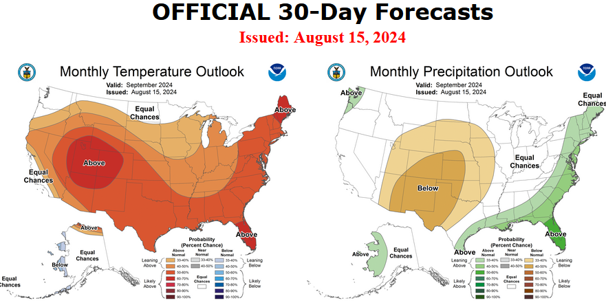
It will be updated on the last day of August.
Then we look at a graphic that shows both the next month and the next three months.
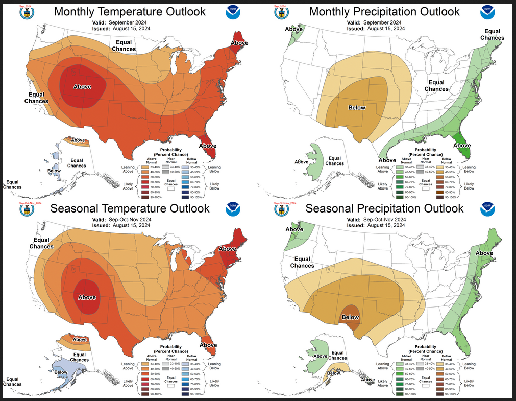
The top row is what is now called the Mid-Month Outlook for next month which will be updated at the end of this month. There is a temperature map and a precipitation map. The second row is a three-month outlook that includes next month. I think the outlook maps are self-explanatory. What is important to remember is that they show deviations from the current definition of normal which is the period 1991 through 2020. So this is not a forecast of the absolute value of temperature or precipitation but the change from what is defined as normal or to use the technical term “climatology”.
| Notice that the Outlook for next month and the three-month Outlook are fairly similar. This tells us that October and November will be fairly similar to September. |
–
