NOAA Updates its Seasonal Outlook on September 19, 2024 – Similar to the Outlook Issued last Month but the potential La Nina is Downgraded – Posted on September 20, 2024
On the third Thursday of the month right on schedule NOAA issued their updated Seasonal Outlook which I describe as their Four-Season Outlook because it extends a bit more than one year into the future. The information released also included the Mid-Month Outlook for the following month plus the weather and drought outlook for the next three months. I present the information issued by NOAA and try to add context to it. It is quite a challenge for NOAA to address the subsequent month, the subsequent three-month period as well as the twelve successive three-month periods for a year or a bit more.
With respect to the long-term part of the Outlook which I call the Four-Season Outlook, the timing of the transition from Neutral to LaNina is challenging to predict. We are now in ENSO Neutral. La Nina is the likely scenario soon, but the strength of the La Nina may be fairly weak..
From the NOAA discussion:
“The most recent International Research Institute (IRI) for Climate and Society plume forecast of the Niño-3.4 SST index predicts a weak and a short duration La Niña, as indicated by the Niño-3.4 index values less than -0.5°C. This month, the latest North American Multi-Model Ensemble (NMME) guidance was relied upon, which predicts La Niña to emerge in the next couple of months and continue through the Northern Hemisphere winter. The continuation of negative subsurface temperatures and enhanced low-level easterly wind anomalies supports the formation of a weak La Nina. In summary, La Niña is favored to emerge in SON (71% chance) and is expected to persist through JFM 2025.”
“However, chances of a moderate to strong La Niña are currently less than 50% through the Fall and Winter. ENSO-neutral conditions are favored to re-emerge by the February-April (FMA) 2025 season.”
I personally would not have total confidence in this outlook given the uncertainty about there actually being a La Nina and its strength if it does happen. I do not have the JAMSTEC outlook yet but for sure they will lean towards a weak La Nina with Modoki characteristics. I do not have a lot of confidence that NOAA knows how to deal with a La Nina Modoki. But they may have it exactly correct.
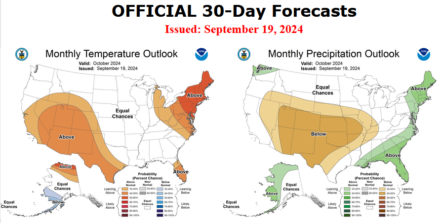
Let’s Take a Look at the (mid-month) Outlook for October
It will be updated on the last day of August.
Then we look at a graphic that shows both the next month and the next three months.
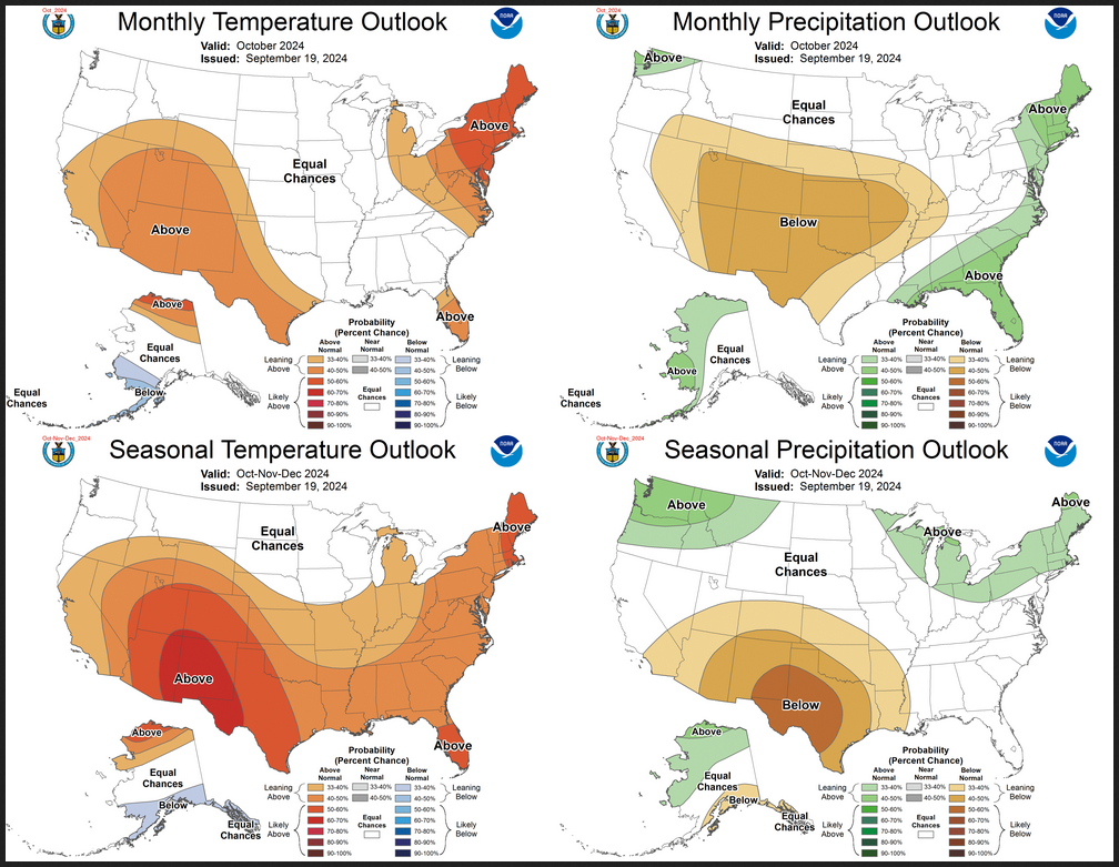
The top row is what is now called the Mid-Month Outlook for next month which will be updated at the end of this month. There is a temperature map and a precipitation map. The second row is a three-month outlook that includes next month. I think the outlook maps are self-explanatory. What is important to remember is that they show deviations from the current definition of normal which is the period 1991 through 2020. So this is not a forecast of the absolute value of temperature or precipitation but the change from what is defined as normal or to use the technical term “climatology”.
| Notice that the Outlook for next month and the three-month Outlook are dissimilar. This tells us that November and December will be substantially different than October. |
–
